
Atlantic Ocean facts for kids
Quick facts for kids Atlantic Ocean |
|
|---|---|

|
|
| Coordinates | 0°N 25°W / 0°N 25°W |
| Basin countries | Countries and ports along the Atlantic |
| Surface area | 85,133,000 km2 (32,870,000 sq mi) North Atlantic: 41,490,000 km2 (16,020,000 sq mi), South Atlantic 40,270,000 km2 (15,550,000 sq mi) |
| Average depth | 3,646 m (11,962 ft) |
| Max. depth | Puerto Rico Trench 8,376 m (27,480 ft) |
| Water volume | 310,410,900 km3 (74,471,500 cu mi) |
| Shore length1 | 111,866 km (69,510 mi) including marginal seas |
| Islands | List of islands |
| Trenches | Puerto Rico; South Sandwich; Romanche |
| Settlements | List |
| 1 Shore length is not a well-defined measure. | |
The Atlantic Ocean is the second-largest ocean on Earth. It covers about 17% of the Earth's surface. It also holds about 24% of all the water on our planet. For a long time, it was seen as the big separator between the "New World" (the Americas) and the "Old World" (Africa, Asia, and Europe).
The Atlantic Ocean has been very important in human history. It played a big part in how societies grew and how countries developed. The Norse people were the first known humans to cross it. But Christopher Columbus's trip in 1492 changed everything. His journey started an age of exploration. European countries like Portugal, Spain, France, and the United Kingdom began to colonize the Americas.
From the 1500s to the 1800s, the Atlantic Ocean was central to the slave trade. It was also key to the Columbian exchange, which moved plants, animals, and cultures between continents. Today, the Atlantic Ocean is still a very important part of global trade.
The Atlantic Ocean has a long, S-shaped basin. It stretches between Europe and Africa in the east, and the Americas in the west. It is connected to the Arctic Ocean in the north. It also links to the Pacific Ocean in the southwest and the Indian Ocean in the southeast. Some people also say it connects to the Southern Ocean in the south. The Equator divides the Atlantic Ocean into two parts: the North Atlantic and the South Atlantic.
Contents
- What Does "Atlantic" Mean?
- How Big is the Atlantic Ocean?
- Biggest Seas in the Atlantic Ocean
- What Does the Ocean Floor Look Like?
- What is Atlantic Ocean Water Like?
- Atlantic Ocean Climate
- How the Atlantic Ocean Formed
- Human History and the Atlantic
- Economy of the Atlantic Ocean
- Environmental Concerns
- Images for kids
- See also
What Does "Atlantic" Mean?

The name "Atlantic" comes from ancient Greek stories. It refers to Atlas, a powerful giant. He was said to hold up the heavens. The name "Atlantic sea" was first used around 450 BC. It meant the sea beyond the "Pillars of Hercules" (near the Strait of Gibraltar). This was seen as part of the ocean that surrounded all land.
Early Greek sailors called the entire ocean "Oceanus." This was a giant river that circled the world. The term "Atlantic" first referred to the Atlas Mountains in Morocco. It also meant the sea off the coast of West Africa.
Another old name for the southern Atlantic was the "Aethiopian Ocean." This name was used until the mid-1800s. During the Age of Discovery, English mapmakers called it the "Great Western Ocean."
People in Britain and America often call the North Atlantic Ocean "the pond." This is a playful way to refer to it. They use it when talking about things "on this side of the pond" or "across the pond." This term has been used since the 1600s.
How Big is the Atlantic Ocean?
The Atlantic Ocean has a very uneven coastline. It has many bays, gulfs, and seas. These include the Baltic Sea, Black Sea, Caribbean Sea, and Gulf of Mexico. Its total coastline, including these smaller seas, is about 111,866 km (69,510 mi).
Including its smaller seas, the Atlantic covers about 106,460,000 km2 (41,100,000 sq mi). This is about 23.5% of all the world's oceans. Its total water volume is about 310,410,900 km3 (74,471,500 cu mi). Without its smaller seas, it covers 81,760,000 km2 (31,570,000 sq mi). The North Atlantic is 41,490,000 km2 (16,020,000 sq mi). The South Atlantic is 40,270,000 km2 (15,550,000 sq mi).
The average depth of the Atlantic is 3,646 m (11,962 ft). The deepest point is the Milwaukee Deep in the Puerto Rico Trench. It goes down 8,376 m (27,480 ft).
Biggest Seas in the Atlantic Ocean
Here are some of the largest seas within the Atlantic Ocean:
- Sargasso Sea – 3.5 million km²
- Caribbean Sea – 2.754 million km²
- Mediterranean Sea – 2.510 million km²
- Gulf of Guinea – 2.35 million km²
- Gulf of Mexico – 1.550 million km²
- Norwegian Sea – 1.383 million km²
- Greenland Sea – 1.205 million km²
- Argentine Sea – 1 million km²
- Labrador Sea – 841,000 km²
- Irminger Sea – 780,000 km²
- Baffin Bay – 689,000 km²
- North Sea – 575,000 km²
- Black Sea – 436,000 km²
- Baltic Sea – 377,000 km²
What Does the Ocean Floor Look Like?

The Atlantic Ocean floor is mostly shaped by a huge underwater mountain range. It is called the Mid-Atlantic Ridge (MAR). This ridge runs from near the North Pole all the way to Bouvet Island in the south. It is like a long seam down the middle of the ocean.
The Mid-Atlantic Ridge
The MAR divides the Atlantic into two halves. It rises about 2 to 3 kilometers above the ocean floor. Its central valley is where the North American and Eurasian plates are pulling apart in the North Atlantic. In the South Atlantic, it's where the South American and African plates are separating. This pulling apart causes basaltic volcanoes to form, like in Iceland.
Most of the MAR is underwater. But in some places, it reaches the surface and forms volcanic islands. These islands are often very special. Four of them are even considered "Outstanding Universal Value" sites. These include parts of Iceland, Portugal's Pico Island, Gough and Inaccessible Islands in the UK, and Fernando de Noronha and Atol das Rocas in Brazil.
The Ocean Floor Features
The edges of the continents that dip into the Atlantic are called continental shelves. They are wide off places like Newfoundland and Europe. The Atlantic has deep trenches in some areas. The Puerto Rico Trench is the deepest, at 8,376 m (27,480 ft) deep. There are also many underwater canyons. These canyons stretch from the continental edges into the deep plains.
In 1922, a ship called the USS Stewart used sonar to map the Atlantic floor. Sonar sends sound pulses that bounce off the bottom. This helps create a map of the ocean's depth. The deep ocean floor is mostly flat. But it also has deep areas, flat plains, trenches, underwater mountains, and canyons.
What is Atlantic Ocean Water Like?

The temperature of the Atlantic's surface water changes. It depends on how far north or south you are, and the time of year. Temperatures can range from below −2 °C (28 °F) to over 30 °C (86 °F). The warmest waters are just north of the equator. The coldest are near the North and South Poles.
From October to June, parts of the Labrador Sea and Baltic Sea are covered in sea ice.
Water in the North Atlantic moves in a clockwise circle. Water in the South Atlantic moves counter-clockwise. This is due to the Coriolis effect. The tides in the Atlantic usually have two high tides every 24 hours.
How Salty is the Atlantic?
The Atlantic is the saltiest major ocean on average. Its surface water has a salinity of 33 to 37 parts per thousand. This means for every 1,000 parts of water, 33 to 37 parts are salt. Salinity changes with location and season. Heavy rainfall near the equator lowers salinity. But areas with low rainfall and high evaporation, like the subtropics, have higher salinity.
The Atlantic's high saltiness helps drive its deep ocean currents. These currents move water around the globe.
Ocean Currents and Gyres

Large circular currents called gyres dominate the Atlantic. The warm-water North Atlantic Gyre spins clockwise in the northern Atlantic. The warm-water South Atlantic Gyre spins counter-clockwise in the southern Atlantic.
In the North Atlantic, the Gulf Stream is a major current. It flows northeast from North America. A part of it, the North Atlantic Current, flows further north. This system of currents brings warm water to the North Atlantic. Without it, temperatures in Europe would be much colder.
The North Atlantic Deep Water (NADW) is a very important deep-water current. It forms in the northern North Atlantic. It then flows south, carrying cold, dense water. This current helps keep Europe warmer than other places at the same latitude.
The Sargasso Sea


The Sargasso Sea is a unique area in the western North Atlantic. It is known for two types of floating seaweed called Sargassum. This area is about 4,000 km (2,500 mi) wide. It is surrounded by major currents like the Gulf Stream. The seaweed has likely been floating there for millions of years, growing without needing to attach to the bottom.
The Sargasso Sea is also a special place for eels. It is the spawning ground for both European and American eels. European eels travel over 5,000 km (3,100 mi) to get there. American eels travel 2,000 km (1,200 mi). Ocean currents then carry the tiny eel larvae back to their feeding areas in North America, Europe, and Africa.
Atlantic Ocean Climate

The Atlantic Ocean greatly affects the climate of nearby lands. This is because oceans can store and release a lot of heat. So, places near the ocean have milder weather. They don't have as many extreme temperature changes as places far inland.
The ocean is the main source of moisture in the air. This moisture comes from evaporation. The warmest climate zones are just north of the equator. The coldest zones are in the polar regions, where there is sea ice. Ocean currents also move warm and cold water around. This affects the climate of the land areas they flow past.
The Gulf Stream and its extension, the North Atlantic Drift, warm the air over the ocean. This keeps places like the British Isles and northwestern Europe mild in winter. Without these currents, these areas would be much colder. Cold currents, like those off eastern Canada, can cause heavy fog.
Natural Dangers

Every winter, strong storms form in the North Atlantic. Icebergs are common from February to July near the shipping lanes off Newfoundland.
Hurricanes are a danger in the western North Atlantic during summer and autumn. They are less common in the South Atlantic.
How the Atlantic Ocean Formed
The Atlantic Ocean sits on top of dense oceanic crust. This crust is made of rocks like basalt. It is covered by fine clay and silt. The edges of the continents, called continental shelves, are made of older, thicker continental rock. The oldest oceanic crust in the Atlantic is about 145 million years old. It is found off the coasts of West Africa and North America.
The Central Atlantic
The Atlantic Ocean began to form when the supercontinent Pangaea started to break apart. This happened in the central Atlantic, between North America and Northwest Africa. This break-up also led to the rise of the Atlas Mountains. This process started around 200 to 170 million years ago.
The breaking apart of Pangaea was linked to huge volcanic eruptions. These eruptions created a large area of volcanic rock called the Central Atlantic magmatic province. This event also happened around the time of a major extinction event about 200 million years ago.
Later, about 2.8 million years ago, the Central American Isthmus formed. This land bridge connected North and South America. It closed off the seaway that used to connect the Atlantic and Pacific. This changed ocean currents, salinity, and temperatures in both oceans. It also led to many animals migrating or going extinct.
The North Atlantic
The northern Atlantic Ocean opened up in stages. This process followed the lines of an older ocean called the Iapetus Ocean. It spread from the central Atlantic. The opening of the North Atlantic caused land along the coast to rise. For example, Greenland's highest point is a huge basalt area.
The North Atlantic Ocean has about 810 underwater mountains, called seamounts. Most of them are along the Mid-Atlantic Ridge.
The South Atlantic
The South Atlantic Ocean formed when the supercontinent Gondwana broke apart. This happened in the Early Cretaceous period, around 130 million years ago. Scientists noticed how well the coastlines of South America and Africa fit together. This was one of the first clues for plate tectonics.
Huge volcanic eruptions happened in the southern part of the South Atlantic. This created a massive amount of volcanic rock. This rock covered large areas of Brazil, Paraguay, Uruguay, and Africa.
The opening of the Drake Passage about 50 million years ago also changed the South Atlantic. This passage between South America and Antarctica allowed ocean currents to flow freely. This led to a colder climate and the growth of the Antarctic ice sheet.
Will the Atlantic Ocean Close?
Scientists believe that the Atlantic Ocean might eventually close up again. This would be part of a natural cycle called the Wilson cycle. A new subduction zone might be forming west of Gibraltar. This could be the start of the Atlantic Ocean slowly closing in the future.
Human History and the Atlantic
Humans first evolved in Africa. The earliest signs of modern human behavior were found along the coast of South Africa. Here, the Atlantic and Indian Ocean currents meet. This created a rich environment with lots of food, like shellfish and fish. This helped early humans survive and develop complex tools.
Old World Connections
About 65,000 years ago, modern humans began to spread out of Africa. They moved into Asia, Europe, and Australia. They quickly replaced older human groups. During the last Ice Age, about 20,000 years ago, humans in Europe had to move south to warmer areas. After the Ice Age, they moved back to the European Atlantic coast. People have lived there permanently for about 9,000 years.
These early people left behind many shell middens (piles of shells). These show how they used marine resources. Over time, they started to use more and more seafood. They also developed new tools like boats, harpoons, and fish-hooks.
New World Connections

The Norse people settled in the Faroe Islands and Iceland in the 800s and 900s CE. They also settled in Greenland before 1000 CE. But contact with Greenland was lost, and the settlement was abandoned. This was due to a colder climate, conflicts with local people, and economic problems.

Christopher Columbus reached the Americas in 1492. Six years later, Vasco da Gama sailed around Africa to India. This proved that the Atlantic and Indian Oceans were connected. In 1500, Pedro Álvares Cabral reached Brazil. He was carried there by the currents of the South Atlantic Gyre.
After these trips, Spain and Portugal quickly conquered and colonized large parts of the Americas. They found a lot of silver and gold. They forced the local people into slavery to work for them. Other European countries, like England, France, and the Netherlands, wanted a share of this wealth. They sometimes worked with pirates to attack Spanish and Portuguese ships.

In the Americas, diseases and slavery greatly reduced the native population. This led to the Atlantic slave trade. Between the 1400s and 1888, about ten million Africans were brought to the Americas as slaves. Most worked on farms. The slave trade was officially ended in the British Empire and the United States in 1808. Slavery itself was abolished later.
From Columbus's time to the Industrial Revolution, trade across the Atlantic was very important for Western Europe. Countries with direct access to the Atlantic grew much richer. This trade also led to more cities growing in these countries. By the late 1600s, Atlantic trade was bigger than trade in the Mediterranean.
Economy of the Atlantic Ocean
The Atlantic Ocean has greatly helped the economies of the countries around it. It provides major routes for shipping and communication. It also has rich deposits of oil and gas under its continental shelves.
The Atlantic also has fish, marine mammals (like seals and whales), sand, gravel, and other valuable minerals. Gold deposits are found deep on the ocean floor. But it is currently too expensive to mine them.
Many international agreements try to reduce pollution in the Atlantic. This includes oil spills, plastic waste, and burning toxic waste at sea.
Fishing in the Atlantic

The continental shelves of the Atlantic have some of the world's best fishing areas. Important areas include the Grand Banks of Newfoundland and the North Sea.
However, fishing has changed a lot since the 1950s. In some parts of the Atlantic, fish catches have gone down. This is often due to overfishing. For example, Atlantic cod off Newfoundland was a huge resource for centuries. But in the early 1990s, the collapse of the Atlantic northwest cod fishery happened because too many fish were caught.
The UN FAO divides the Atlantic into major fishing areas:
- Northeast Atlantic

Total fish catches in the Northeast Atlantic went down from the 1970s to the 1990s. Some fish, like Arctic cod, have recovered. But others, like Sand eel, are still overfished. About 21% of fish stocks here are considered overfished. The main fish caught are herring, mackerel, and sprats.
- Northwest Atlantic

Fish catches in the Northwest Atlantic have also decreased since the 1970s. Some species, like Greenland halibut, are slowly recovering. But others, like cod, are not. About 31% of fish stocks here are overfished.

The discovery of huge amounts of Atlantic cod off Newfoundland in 1497 was very important. For 500 years, about 200 million tons of cod were caught. But too much fishing led to the collapse of the cod fishery in the early 1990s. Other deep-sea fish populations also collapsed.
- Eastern Central Atlantic
In this area, small pelagic fish (fish that live near the surface) make up about half of the catches. Sardines are a major catch. Almost half of the fish stocks here are being fished at levels that are not sustainable.
- Western Central Atlantic

Catches in the western central Atlantic have been going down since 2000. The most important fish, Gulf menhaden, has seen its catch cut in half. Many fish, like Groupers and snappers, are overfished. About 44% of fish stocks here are being fished at unsustainable levels.
- Southeast Atlantic

Catches in the southeast Atlantic have decreased since the 1970s. Horse mackerel and hake are the most important fish. Some hake species have recovered to sustainable levels due to new rules.
- Southwest Atlantic
Catches in the southwest Atlantic reached a peak in the mid-1980s. The most important fish, the Argentine shortfin squid, is considered fully fished or overfished. Half of the fish stocks in this area are being fished at unsustainable levels.
Environmental Concerns
Animals in Danger
Many marine animals in the Atlantic are endangered. These include the manatee, seals, sea lions, turtles, and whales. Fishing with large drift nets can accidentally kill dolphins, albatrosses, and other seabirds. This also harms fish populations.
Pollution in the Ocean
Marine pollution is when harmful chemicals or particles enter the ocean. Rivers are a big source of pollution. They carry farm chemicals, human waste, and animal waste into the sea. Too many chemicals can cause areas with low oxygen, called "dead zones."
.jpg)
Marine debris is human-made trash floating in the water. This trash often gathers in the center of ocean gyres and along coastlines. The North Atlantic garbage patch is a huge area of trash that is hundreds of kilometers wide.
Other pollution problems include waste from cities and oil spills. Oil pollution is a concern in the Caribbean Sea and Gulf of Mexico. Industrial waste and sewage pollute the Baltic Sea and North Sea.
Images for kids
-
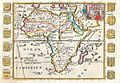
The Aethiopian Ocean depicted in a 1710 French map of Africa
-
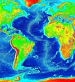
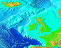
False color map of ocean depth in the Atlantic basin
-
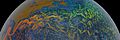
As the Gulf Stream meanders across the North Atlantic from the North American east coast to Western Europe its temperature drops by 20 °C (36 °F).
-
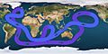
Path of the thermohaline circulation. Purple paths represent deep-water currents, while blue paths represent surface currents.
-
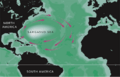
Approximate extent of the Sargasso Sea
-
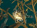
Sargassum fish (Histrio histrio)
-
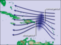
Waves in the trade winds in the Atlantic Ocean – areas of converging winds that move along the same track as the prevailing wind – create instabilities in the atmosphere that may lead to the formation of hurricanes.
-
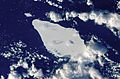
Iceberg A22A in the South Atlantic Ocean
-
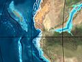
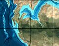
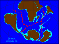
Opening of the central Atlantic 200-170 Ma
-
Opening of the central Atlantic 200-170 Ma
-
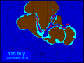
The opening of the South Atlantic
-
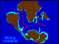
The opening of the South Atlantic
-
The opening of the South Atlantic
-
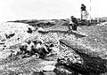
Excavation of the Ertebølle middens in 1880
-
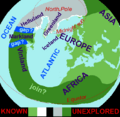
Based on the medieval Íslendingasögur sagas, including the Grœnlendinga saga, this interpretative map of the "Norse World" shows that Norse knowledge of the Americas and the Atlantic remained limited.
-
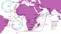
The Atlantic Gyres influenced the Portuguese discoveries and trading port routes, here shown in the India Run ("Carreira da Índia"), which would be developed in subsequent years.
-
Embarked and disembarked slaves in the Atlantic slave trade 1525–1863 (first and last slave voyages)
-
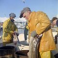
Cod fishery in Norway
-
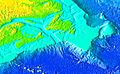
Banks of the northeast Atlantic
-
Banks of the northwest Atlantic
-
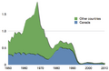
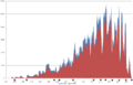
Capture of Atlantic northwest cod in million tons
-
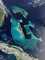
Bahama Banks
-
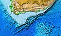
Agulhas Bank
-
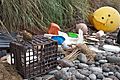
Marine debris strewn over the beaches of the South Atlantic Inaccessible Island


See also
 In Spanish: Océano Atlántico para niños
- Atlantic Revolutions
- List of countries and territories bordering the Atlantic Ocean
- List of rivers of the Americas by coastline § Atlantic Ocean coast
- Seven Seas
- Shipwrecks in the Atlantic Ocean
- Atlantic hurricanes
- Piracy in the Atlantic World
- Transatlantic crossing
- South Atlantic Peace and Cooperation Zone
- Natural delimitation between the Pacific and South Atlantic oceans by the Scotia Arc
