
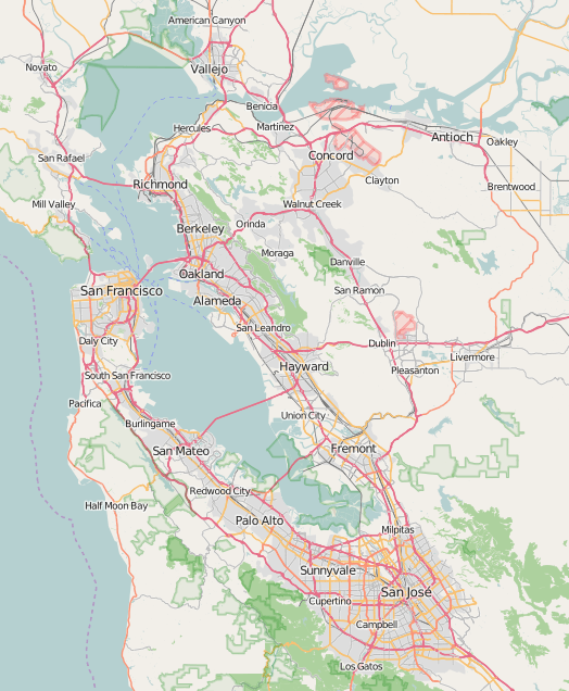
Image: Location Map San Francisco Bay Area
Description: Location map of the San Francisco Bay Area.
Title: Location Map San Francisco Bay Area
Credit: You may find a page on the OpenStreetMap wiki page for San Francisco Bay Area
Author: Mliu92, sourced from OpenStreetMap, under the Open Database License OpenStreetMap Foundation
Permission: OpenStreetMap data is available under the Open Database License (details). Map tiles are licensed under the Creative Commons Attribution-ShareAlike 2.0 license (CC-BY-SA 2.0). Contains map data © OpenStreetMap contributors, made available under the terms of the Open Database License (ODbL). The ODbL does not require any particular license for maps produced from ODbL data; map tiles produced by the OpenStreetMap foundation are licensed under the CC-BY-SA-2.0 licence, but maps produced by other people may be subject to other licences.Open Database LicenseODbLhttp://opendatacommons.org/licenses/odbl/1.0/true This file is licensed under the Creative Commons Attribution-Share Alike 2.0 Generic license. You are free: to share – to copy, distribute and transmit the work to remix – to adapt the work Under the following conditions: attribution – You must give appropriate credit, provide a link to the license, and indicate if changes were made. You may do so in any reasonable manner, but not in any way that suggests the licensor endorses you or your use. share alike – If you remix, transform, or build upon the material, you must distribute your contributions under the same or compatible license as the original. https://creativecommons.org/licenses/by-sa/2.0 CC BY-SA 2.0 Creative Commons Attribution-Share Alike 2.0 truetrue
Usage Terms: Creative Commons Attribution-Share Alike 4.0
License: CC BY-SA 4.0
License Link: https://creativecommons.org/licenses/by-sa/4.0
Attribution Required?: Yes
Image usage
More than 100 pages link to this image. The following list shows the first 100 page links to this image only. A full list is available.
- Alameda, California
- Andrus Island
- Angel Island (California)
- Aramburu Island
- Ardenwood Historic Farm
- Arthur and Mona Hofmann House
- Bair Island
- Bay Farm Island, Alameda, California
- Belvedere Island
- Bethel Island
- Bird Island (Marin County, California)
- Bird Island (San Mateo County, California)
- Bouldin Island
- Bradford Island
- Brewer Island
- Brooks Island Regional Preserve
- Browns Island (California)
- Browns Island (Contra Costa County)
- Bull Island (California)
- Burdell Island
- Campbell, California
- Casa de Tableta
- Chipps Island
- Coast Guard Island
- Contra Costa Centre, California
- Coon Island (California)
- Corinthian Island
- Corte Madera, California
- Daly City, California
- Day Island (California)
- Decker Island
- Deer Island (Marin County)
- Don Edwards San Francisco Bay National Wildlife Refuge
- Drawbridge, California
- Dutton Island
- Edgerly Island
- Emeryville Crescent State Marine Reserve
- Eugene O'Neill National Historic Site
- Folger Estate Stable Historic District
- Ford Motor Company Assembly Plant
- Foster City, California
- Fox Theatre (Redwood City, California)
- Freeman Island (California)
- Fremont, California
- Golden Gate
- Golden Gate National Recreation Area
- Greco Island
- Green Island (California)
- Grizzly Island
- HP Garage
- Hammond Island (California)
- Hog Island (Petaluma River)
- Holbrook-Palmer Estate
- Hooks Island
- Island No. 1
- Island No. 2
- Jakes Island
- James Johnston House (Half Moon Bay, California)
- John Muir National Historic Site
- Kaiser Richmond Field Hospital
- Kohl Mansion
- Lathrop House (Redwood City, California)
- Los Gatos, California
- Mare Island
- Martin's Beach
- Martinez, California
- Martinez Library
- Meek Mansion
- Mill Valley, California
- Milpitas, California
- Mission Cultural Center for Latino Arts
- Mussel Rock
- Old St. Raymond's Church
- Point Richmond Historic District
- Professorville
- Ralston Hall
- Redwood City Historic Commercial Buildings
- Redwood Shores, California
- Richmond, California
- Richmond Shipyards
- Rosie the Riveter World War II Home Front National Historical Park
- San Francisco Bay Discovery Site
- San Francisco Peace Pagoda
- San Leandro, California
- San Rafael, California
- Sausalito, California
- Seal Rock (San Mateo County, California)
- Seal Rocks (San Francisco, California)
- Shelter Cove, Pacifica, California
- Sherman Island (California)
- Silicon Valley
- Skaggs Island Naval Communication Station
- South San Francisco hillside sign
- Sánchez Adobe Park
- Tamalpais-Homestead Valley, California
- The Brothers (San Francisco Bay)
- The Sisters (California)
- Visitacion Valley, San Francisco
- Walnut Creek, California
- Winehaven, California
