
La Paz facts for kids
Quick facts for kids
La Paz
|
|||
|---|---|---|---|
| Nuestra Señora de La Paz | |||
|
|
|||
|
|||
| Motto(s):
Los discordes en concordia, en paz y amor se juntaron y pueblo de paz fundaron para perpetua memoria. ("The dissenters in harmony gathered together in peace and love, and a town of peace they founded, for perpetual memory.")
|
|||

La Paz
Location in Bolivia

La Paz
Location in South America
|
|||
| Country | Bolivia | ||
| Department | La Paz | ||
| Province | Pedro Domingo Murillo | ||
| Founded |
20 October 1548 by Alonso de Mendoza
|
||
| Independence | 16 July 1809 | ||
| El Alto incorporated | 20th century | ||
| Area | |||
| • Seat of Government | 472 km2 (182 sq mi) | ||
| • Urban | 3,240 km2 (1,250 sq mi) | ||
| Elevation | 3,640 m (11,942 ft) | ||
| Population
(2024 census)
|
|||
| • Seat of Government | 755,732 | ||
| • Density | 1,861.2/km2 (4,820.6/sq mi) | ||
| • Metro | 2,187,223 | ||
| GDP (PPP, constant 2015 values) | |||
| • Year | 2023 | ||
| • Total (Metro) | $14.6 billion | ||
| • Per capita | $8,400 | ||
| Time zone | UTC−04:00 (Bolivia Time) | ||
| • Summer (DST) | (Not Observed) | ||
| Postal code |
0201-0220
|
||
| Area code(s) | 2 | ||
| ISO 3166 code | BO-L | ||
| HDI (2016) | 0.827 (Very High) | ||

.jpg)
.jpg)


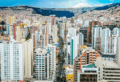
La Paz, officially called Nuestra Señora de La Paz, is a very important city in Bolivia. It is where the government of Bolivia is located. With over 755,000 people in 2024, it is the third largest city in Bolivia. If you include nearby cities like El Alto, the whole area has about 2.2 million people. This makes it the second biggest urban area in Bolivia. La Paz is also the capital of the La Paz Department.
The city is in west-central Bolivia, about 68 kilometers (42 miles) from Lake Titicaca. It sits in a valley shaped like a bowl, surrounded by tall mountains. The huge, snow-covered Illimani mountain watches over the city. You can see its peaks from many places in La Paz. At about 3,650 meters (11,975 feet) above sea level, La Paz is the highest capital city in the world. Because it's so high up, La Paz has a special kind of climate. It has rainy summers and dry winters.
La Paz was started on October 20, 1548, by a Spanish explorer named Captain Alonso de Mendoza. He built it where an Inca village called Laja used to be. It was a stop between important trading routes. The city was first named Nuestra Señora de La Paz, which means Our Lady of Peace. This name celebrated peace after a rebellion. The city was later moved to its current spot. La Paz was ruled by Spain for a long time. But people in the city often fought for their freedom. In 1781, an indigenous leader named Túpac Katari surrounded the city for six months. On July 16, 1809, a Bolivian hero, Pedro Domingo Murillo, started a revolution. This was the start of the fight for independence in South America.
Today, La Paz is the center of Bolivia's government. It has the presidential palace, called the Palacio Quemado. It also has the Bolivian legislature, where laws are made. Many government offices are here too. While La Paz is the seat of government, Sucre is the official capital and holds the country's main court. La Paz is also a big center for business and sports in Bolivia. It produces a lot of the country's wealth.
La Paz is also a very important cultural city in South America. It has old buildings from colonial times, like the San Francisco Church. The Plaza Murillo and Jaén Street are also famous. The city is known for its markets, especially the Witches' Market. You can find amazing views of the city and mountains from many spots. La Paz also has the world's largest urban cable car network.
Contents
- What Does the Name La Paz Mean?
- A Brief History of La Paz
- The Geography of La Paz
- Districts and Neighborhoods
- What is the Cityscape of La Paz Like?
- Colonial Architecture in La Paz
- The Economy of La Paz
- Sports in La Paz
- Education in La Paz
- What Can You See and Do in La Paz?
- What Kind of Food Can You Eat in La Paz?
- Local Festivals in La Paz
- How to Get Around La Paz
- Communications and Media
- Water Supply in La Paz
- International Connections
- Famous People from La Paz
- Images for kids
- See also
What Does the Name La Paz Mean?

The Spanish explorers founded the city in 1548. They called it Nuestra Señora de La Paz. This means Our Lady of Peace. The name was chosen to celebrate peace. It came after a rebellion by explorers against the first ruler of Peru.
In 1825, after Bolivia won its freedom from Spain, the city's name changed. It became La Paz de Ayacucho. This means The Peace of Ayacucho. It honored a big battle where the Spanish army was defeated.
The area where La Paz is located was known as Chuquiago Marka in the Aymara language. Marka means village. Chuqi Yapu means 'gold farm'. This was likely because of gold found in the local rivers.
A Brief History of La Paz
This area was once an Inca city. It was on an important trading route.
Spanish explorers arrived in 1535. But they did not found La Paz until 1548. The first spot chosen was a Native American settlement called Laja. A few days later, the town was moved to its current, nicer valley location.
The Spanish king, Emperor Charles V, put Pedro de la Gasca in charge of the Inca lands. Gasca told Alonso de Mendoza to start a new city. This city would celebrate the end of civil wars in Peru. So, La Paz was founded on October 20, 1548. Juan de Vargas became its first mayor.
In 1549, Juan Gutierrez Paniagua was asked to plan the city. He designed places for public areas, plazas, and buildings. The Plaza de los Españoles was chosen for government buildings. Today, this is known as the Plaza Murillo.
Spain ruled La Paz very strictly. The Spanish king made all the big decisions. But it took months for messages to travel by sea. Local people often protested this rule. In 1781, a group of Aymara people surrounded La Paz for six months. They destroyed churches and government property. Thirty years later, another siege happened. This event led to the legend of the Ekeko, a small god of abundance.
On July 16, 1809, Pedro Domingo Murillo started a revolution. He said it was like lighting a lamp that no one could put out. This event began the fight for South American freedom from Spain. The first open rebellions against Spain happened in La Paz and Sucre at the same time. This is known as the Primer Grito Libertario de América. It led to the Bolivian War of Independence.

Pedro Domingo Murillo was executed on January 29, 1810. After Bolivia became independent, La Paz named its main plaza after him. This was to honor him forever. He is remembered as a hero of the revolution.
In 1898, La Paz became the main seat of the national government. Sucre remained the official capital and judicial center. This change happened because Bolivia's economy shifted. It moved from silver mines in Potosí to tin mining near Oruro. This changed who held economic and political power.
The Geography of La Paz
.jpg)
La Paz is located in the valleys of the Andes mountains. It is close to the eastern edge of the Altiplano region. The city is near the Cordillera Real mountain range. This range includes famous mountains like Illimani, Mururata, and Huayna Potosi.
La Paz is built in a canyon. This canyon was formed by the Choqueyapu River. The river now mostly flows under the city. The city's main road follows the river's path. Its central part, lined with trees, is called the Prado.
The geography of La Paz also shows social differences. Wealthier people live in the lower, central parts of the city. Many middle-class people live in tall apartment buildings near the center. People with lower incomes live in simple brick houses on the surrounding hills. The city of El Alto, where the airport is, spreads out to the west of the canyon. It is located on the high plains.
In July 1994, a strong earthquake hit about 200 miles north of La Paz. It was felt in La Paz and damaged villages nearby. In February 2002, a big hail and rainstorm caused flooding. This caused serious damage and led to over 50 deaths.
What is the Climate Like in La Paz?

Higher parts of La Paz are over 4,000 meters (13,123 feet) above sea level. These areas have a cold subtropical highland climate. Night-time temperatures can be very cold. Light snow can fall in winter, usually melting by noon. Even though it's close to the equator, these parts of the city have average temperatures similar to cities in Norway.
Temperatures in central La Paz, at 3,600 meters (11,811 feet), are warmer. The southern part of the city, at 3,250 meters (10,663 feet), is even warmer. These areas have subtropical highland climates. Heavy rain often falls in summer. This can cause dangerous mudslides.
The whole city has rainy summers and dry winters. Most rain falls from November to March. The wettest month is January. The driest months are June and July.
In the highest parts of the city, above 4,000 meters, February and March are the cloudiest months. The sunniest months are June and July, during winter.
Districts and Neighborhoods
La Paz is divided into different districts and neighborhoods. Each has its own unique feel.
| La Paz's districts | |||||||
| # | District | Population | Area (km2) | Type | Map | ||
| 1 | Mallasa | 5,082 | 32,68 | Urbano | |||
| 2 | Zona Sur | 127,228 | 64,15 | Urbano | |||
| 3 | San Antonio | 115,659 | 22,59 | Urbano | |||
| 4 | Periférica | 159,123 | 26,05 | Urbano | |||
| 5 | Max Paredes | 164,566 | 13,31 | Urbano | |||
| 6 | Centro | 64,272 | 5,22 | Urbano | |||
| 7 | Cotahuma | 153,655 | 16,10 | Urbano | |||
| 23 | Zongo | Rural | |||||
| 22 | Hampaturi | Rural | |||||
| La Paz's neighborhoods | ||||
|---|---|---|---|---|
| # | District | Map | Neighborhoods | Main streets |
| 1 | Mallasa |  |
Amor de Dios • Mallasa • Muela del Diablo • Mallasilla • Jupapina | Carretera principal Rio abajo |
| 2 | Zona Sur |  |
Obrajes • Bella Vista • Bolonia • Irpavi • Calacoto • Cota Cota • Achumani • Ovejuyo • Koani • La Florida • Seguencoma • San Miguel | Avenida Ballivián |
| 3 | San Antonio |  |
San Antonio • Villa Copacabana • Pampahasi • Valle Hermoso • Kupini • Villa Armonía • Callapa, •San Isidro | Avenida cd del niño |
| 4 | Periférica |  |
Achachicala • Chuquiaguillo • Villa Fátima • Vino Tinto •5 Dedos • Santiago de Lacaya • Rosasani | Avenida Grl Juan Jose Torres |
| 5 | Max Paredes |  |
Munaypata • La Portada • El Tejar • Gran Poder • Obispo Indaburu • Chamoco Chico • Munaypata • Pura Pura • Ciudadela Ferroviaria | Avenida Naciones Unidas |
| 6 | Zona Centro |  |
Casco Urbano Central • San Jorge • Miraflores • Barrio Gráfico • San Sebastián • Santa Bárbara • Parque Urbano Central | Avenida Arce • Avenida 16 de Julio |
| 7 | Cotahuma |  |
Sopocachi • Alto Sopocachi • Pasankeri • Tembladerani • Alpacoma • Belén • Tacagua • San Pedro • Bajo Llojeta | Avenida Buenos Aires |
Main Neighborhoods and Zones
- San Jorge
-
 Buildings in Sopocachi, in the district of Cotahuma

This area is in the Cotahuma district, near Sopocachi. It is a main residential and diplomatic area. San Jorge used to be one of the most exclusive neighborhoods. It was a financial center with many international companies. Now, it has some of Bolivia's tallest buildings. These include Torre Girasoles and Torres del Poeta. It also has the country's only smart building, Torre Azul. The neighborhood has expensive offices, famous restaurants, museums, and bookstores. Its Avenida Arce is one of the city's main streets. It has the most upscale shops in Bolivia. San Jorge is home to many embassies. These include the United States, United Kingdom, and Japan.
This neighborhood is also in the Cotahuma district. It is one of the oldest residential areas. It is only 10 minutes from the city center. Even with new buildings, it has kept its residential feel. Recently, many new shops and businesses have opened here. They are mostly around Abaroa Square, one of the area's many parks.
- San Pedro
This area is in the Cotahuma district, by the Choqueyapu River. It is built around "Plaza de San Pedro." This plaza is officially called Plaza Sucre. San Pedro has many shops and small businesses. These include printing shops and car repair shops. San Pedro's "Rodriguez Market" is one of the city's oldest and most popular markets. The San Pedro prison is also located here.

- Centro
This is the city's downtown area. It is in the 7th District. It includes the main roads of La Paz. These are Arce Avenue, 16 July Avenue (also known as "Prado Avenue"), Mariscal Santa Cruz Avenue, and Camacho Avenue. Camacho Avenue has the main offices of Bolivia's biggest banks and companies.
- Casco Viejo
This is the historic and oldest part of La Paz. It is in the 7th District. Now, it has museums, hotels, and shops. The Mayor City of La Paz and the Central Bank of Bolivia are here. The Plaza Murillo is in the Old Quarter. This plaza is home to the Government Palace and the National Congress.
- Miraflores
This district is in the 7th District. It is separated from downtown by a large park called Parque Urbano Central. It is connected by the Bridge of the Americas and two avenues. Miraflores was first a residential area. Now, it is a major place for fun and activities. It has universities and hospitals. The Estadio Hernando Siles, a big football stadium, is also here.
- Northern District
This district is in the 2nd and 3rd districts. It has a lot of factories, mainly for food. The Cervecería Boliviana Nacional (Bolivian National Brewery) is a very important factory here. It was started by Germans. It is one of the city's biggest companies. This district connects La Paz with El Alto by a highway.
- Southern District

This district is in the 5th district. It is lower in altitude than the rest of La Paz. It is called the "Macrodistrito Sur." It has three districts with an area of 47.8 square kilometers. The population density was about 3,084 people per square kilometer in 2016. Obrajes, Bolognia, Achumani, and Calacoto are some neighborhoods here. This area is growing fast, both in population and new buildings. It has some of the city's richest and most exclusive neighborhoods. It has grown because of good economic growth. It is now the second biggest business and financial center in the city. It has international companies like Citibank and Samsung Electronics. It also has the "MegaCenter," which is La Paz's biggest shopping mall.
What is the Cityscape of La Paz Like?

Colonial Architecture in La Paz


La Paz has fewer and fewer colonial buildings. Most of them are around Plaza Murillo. Many old buildings have been torn down or are falling apart. This is because there isn't enough money to fix them. Also, it costs a lot to keep old buildings. So, owners often prefer to build new, modern ones. There are plans to restore some colonial buildings. But it is not certain what will happen to these historic places.
The Economy of La Paz


The economy of La Paz has gotten much better recently. This is mainly because the country has become more stable. In the 1980s and early 1990s, Bolivia had high inflation and economic problems. This led to a large informal economy. You can see this in the many markets all over the city.
Even though there are regular markets, almost every street in downtown has at least one street vendor.
La Paz is still the main center for making finished goods in Bolivia. About two-thirds of Bolivia's manufacturing is located nearby. In the past, Bolivia's industry was mostly about processing minerals and farm products. But in La Paz, many small factories do a lot of the work. They make food, tobacco products, clothes, and building materials. They also make tools for farming.
Sports in La Paz

La Paz is home to some of Bolivia's biggest football (soccer) teams.
- Club Bolívar: This team was started in 1925. It was named after the hero Simón Bolívar. It has won most national and international championships in the last 20 years. It is the most popular team in the country.
- The Strongest: This club was founded in 1908. They play some games and train at their home stadium, Rafael Mendoza. In 1968, almost all the players died in a plane crash. But Rafael Mendoza worked hard to help the team rise again.
- La Paz F.C.: This club was founded in 1989. It quickly became the third major club in the capital. It is less popular than the two older rival teams.
Several other teams also play in the city. Most of these teams play their games at the Estadio Hernando Siles. This is the city's main stadium. It also hosts the national football team and international games.
Education in La Paz
The city has some of the most important universities in the country.
| Foundation | University | World Ranking 2012 (CSIC Webometrics) | Latin American Ranking 2012 (CSIC Webometrics) | Academic Production(Ranking Scimago Lab) | National Ranking | Logo | Web | ||
| 1830-10-25 | Universidad Mayor de San Andrés | UMSA | Estatal | 2266 | 182 | – | 2 | UMSA | |
| 1994-03-21 | Universidad Católica Boliviana San Pablo | UCB | Privada | 3449 | 308 | – | 3 | UCB | |
| – | Universidad Central de Bolivia | UNICEN | Privada | 4919 | 489 | – | 5 | UNICEN | |
| – | Universidad Privada del Valle | UPV | Privada | 7686 | 757 | – | 8 | UPV | |
| – | UP Boliviana | UPB | Privada | 8206 | 822 | – | 9 | Universidad Privada Boliviana | |
| 1950 | Escuela Militar de Ingeniería | EMI | Estatal | 10670 | 1103 | – | 13 | EMI | |
| – | Universidad Salesiana de Bolivia | Privada | 11280 | 1174 | – | 16 | Salesiana | ||
| – | Universidad Nur Bolivia | Privada | 12461 | 1333 | – | 18 | NUR | ||
| – | Universidad Loyola | Privada | 13398 | 1499 | – | 20 | Loyola | ||
| – | Universidad Andina Simón Bolívar Bolivia | UASB | Estatal | 13418 | 1506 | – | 21 | UASB | |
What Can You See and Do in La Paz?

-6.jpg)
La Paz is a major cultural center in Bolivia. The city has several old cathedrals from colonial times. These include the San Francisco Cathedral and the Metropolitan Cathedral. The Metropolitan Cathedral is on Murillo Square. This square is also where the country's political power is located. You can find hundreds of different museums across the city. The most famous ones are on Jaén Street. This street has kept its old Spanish design. It is home to 10 different museums.
The home of the Bolivian government is on Murillo Square. It is known as "Palacio Quemado," which means "Burnt Palace." This is because it has caught fire several times. The palace has been rebuilt many times, but the name has stayed the same.
Principal Attractions in La Paz
Museums and Cultural Centers

- The old home of Pedro Domingo Murillo is now a museum. He was a hero of the independence revolution in 1809. The house shows furniture, fabrics, and art from colonial times.
- Museo Costumbrista: This museum shows ceramic dolls. They wear traditional clothes from the early 19th century. It also has old photos of La Paz.
- Museo Nacional de Arqueología (National Museum of Archeology): This museum has a collection of items from the Tiawanaku culture.
- Museo del Litoral (Museum of the Coastal Region): This museum shows items from the 1879 war. In this war, Bolivia lost its coast to Chile.
- Museo del Oro (Gold Museum): This museum displays items made of gold, silver, and copper. They were made before the Spanish arrived.
- Museo de Etnografía y Folklore (Ethnography and Folklore Museum): This museum is in a house built in the late 1700s. It shows the customs and art of two groups: Chipayas and Ayoreos.
- Museo del Charango (Museum of Charango): This museum is on Calle Linares. It shows many different charangos. Other native instruments are also displayed.
- Museo de Historia Natural (Natural History Museum): This museum has exhibits on Bolivia's ancient animals, rocks, and plants.
- Casa Museo Marina Nuñez del Prado (Marina Nuñez del Prado House Museum): This museum shows sculptures by Bolivian artist Marina Nuñez del Prado. Her works are about Quechua and Aymara themes.
_y_Catedral_Metropolitana_de_La_Paz,_Bolivia.jpg)
- Museo Nacional de Arte (National Art Museum): This museum is on Calle Comercio. It is in an old palace built in 1775. It shows art by famous artists like Melchor Perez de Holguín.
- Mercado de Brujas (Witches' Market): Here, you can buy herbs and remedies. These are used in Aymara traditions.
- Feria de Alasitas: This fair happens for two weeks each year, starting January 24. The main figure is a small god of good luck called Ekeko. In 2017, UNESCO recognized it as an important cultural heritage.
- Museo San Francisco Cultural Center
Churches and Cathedrals

- Metropolitan Cathedral: Built in 1835. It is next to the Presidential Palace on Murillo Square.
- San Francisco Church: Founded in 1548 and rebuilt in 1784.
- San Jose of the Recoleta Church: Founded in 1896 and finished in 1930.
- Parroquia Señor de la Exaltación: Founded in 1956.
Other Attractions
- Bolivian Presidential Palace: Also known as "Burned Palace."
- Parque Urbano Central (Central Urban Park)
- Valle de la Luna (Bolivia) (Moon Valley)
- El Montículo
- Mirador Laikakota
- Mirador Killi Killi
What Kind of Food Can You Eat in La Paz?

Some popular foods from La Paz include:
- Marraqueta (a type of bread)
- Plato Paceño (a dish with lima beans, potatoes, corn, and cheese)
- Salteña (a savory pastry)
- Fricasé (a hearty stew)
- Picante Mixto (a spicy mixed dish)
- Api and Pastel (a purple corn drink with a fried pastry)
- Llaucha (a cheese pastry)
- Papa Rellena (stuffed potato)
- Ranga ranga (a tripe stew)
- Chairo (a soup)
- Sandwich de Chola (a pork sandwich)
- Anticucho (skewered meat)
Local Festivals in La Paz
-1.jpg)
- January: Achocalla Festival: This festival happens in the first week of January. People celebrate with traditional dances, music, and a parade. It marks when potato fields start to bloom.
- January 24: Alasitas: This is a yearly fair. People buy tiny gifts and honor the god of good luck, Ekeko. The fair starts on January 24 and lasts for a month. UNESCO recognized it as an important cultural heritage in 2017.
- May: Santísima Trinidad del Señor Jesús del Gran Poder: This festival happens on Trinity Sunday, so the date changes each year. It usually takes place in late May or early June. Over 30,000 dancers perform in the streets. They wear colorful costumes and dance to Aymara and Catholic traditions. The parade lasts all day and night. In 2019, UNESCO recognized it as an important cultural heritage.
- July 16: Virgen del Carmen: This is the patroness of Bolivia and its Armed Forces.
- August 15: Virgen de Urqupiña
- August 15: Virgen de la Asunción
How to Get Around La Paz

Cars and public transport are the main ways to travel in La Paz. In March 2012, over 1.5 million vehicles were registered. Heavy traffic is common in the city center. Traffic jams often happen during busy hours.
Highways
The La Paz-El Alto Highway is a toll road. It connects La Paz with the nearby city of El Alto. This is the city's main highway. It makes it easy to get to El Alto International Airport. The highway is 11.7 kilometers (7.3 miles) long. It crosses through El Alto.

-
Autopista La Paz-El Alto/RN-3 (La Paz-El Alto Highway) – Connects La Paz with El Alto.

-
Autovía La Paz Oruro/A-1 (La Paz-Oruro Highway) – Connects La Paz with Oruro. From Oruro, you can go to Sucre, Potosí, and other southern cities.

The Southern District is a wealthy and business-focused area. It is somewhat separate from the rest of the city. The Avenida Costanera and Avenida Kantutani connect it to the main city area.
Air Travel

El Alto International Airport (LPB) is La Paz's airport. It handles both national and international flights. It is a main hub for airlines like Línea Aérea Amaszonas. The airport is in the city of El Alto. It is about 8 miles (13 km) southwest of La Paz's city center. At 4,061 meters (13,323 feet) above sea level, it is the highest international airport in the world. The runway is 4,000 meters (2.5 miles) long. It is one of Bolivia's three main international airports.
Airlines like Avianca and LATAM Airlines fly to El Alto International Airport. They offer direct flights to cities like Bogotá and Lima. However, most international flights, including those to Europe, use Viru Viru International Airport in Santa Cruz de la Sierra. That airport is at a much lower altitude and can handle bigger planes.
The airport also provides oxygen for travelers. This helps those who feel sick from the high altitude.
Bus Travel

The La Paz Bus Station was designed by the French architect Gustave Eiffel. It is the main place for buses between cities. Many buses leave daily for all major Bolivian cities. There are also routes to Chile and Peru. The city is connected by road to Oruro. From Oruro, you can go to Sucre, Potosí, and the south. Another highway goes to Cochabamba and Santa Cruz. Roads to the west go to Copacabana and Tiwanaku, near Lake Titicaca. They continue to Cuzco, Peru. There are also roads north to Yungas, crossing the Andes Mountains.
Buses to smaller towns use informal stations. For example, Villa Fátima is for trips to Los Yungas.
Cable Car System

A system of urban cable cars called Mi Teleférico ("My Cable Car") opened in 2014. It is the largest urban cable car system in the world. Eight lines are currently running. Three more lines are being planned. The first two lines (Red and Yellow) connected La Paz with El Alto. All stations have both a Spanish name and an Aymara name.
| Line | Length | Travel time | Stations | opened |
|---|---|---|---|---|
| Red Line | 2.4 km | 10 min | 3 | May 2014 |
| Yellow Line | 3.9 km | 13.5 min | 4 | September 2014 |
| Green Line | 3.7 km | 16.6 min | 4 | December 2014 |
| Blue Line | 4.7 km | 17 min | 5 | March 2017 |
| Orange Line | 2.6 km | 10 min | 4 | September 2017 |
| White Line | 2.9 km | 13.1 min | 4 | March 2018 |
| Sky Blue Line | 2.6 km | 11.8 min | 4 | July 2018 |
| Purple Line | 4.3 km | 16.2 min | 3 | September 2018 |
Communications and Media
- The postal service is run by ECOBOL. This is a national company based in La Paz. Other companies also offer mail and shipping services.
- The private company Entel is in the city. It provides phone, Internet, and cell phone services. The phone company Cotel also manages many phones. It now offers Internet and cable TV.
- The area code for La Paz is 2. The country code for Bolivia is 591.
- The main daily newspapers are Página Siete, La Razon, and El Diario.
- There are 18 TV channels with offices in La Paz. Channel 7 is owned by the government. Other main channels are Unitel, ATB Bolivia, and Red Uno. Channel 13 is run by the Universidad Mayor de San Andres.
Water Supply in La Paz

The water supply for La Paz is at risk. This is due to climate change and melting glaciers. The city gets its drinking water from three systems. These are El Alto, Achachicala, and Pampahasi. La Paz shares the largest system with El Alto. All three systems get water from glaciers and rivers in the Cordillera mountains. About 20-28% of its water comes from glaciers. The rest comes from rain and melting snow.
Glaciers are shrinking because of climate change. At first, this increases water during the dry season. But eventually, there will be much less water when the glaciers disappear. A small glacier, the Chacaltaya, disappeared in 2008. The Tuni and Condoriri glaciers lost 39% of their area between 1983 and 2006. Experts say that reducing water loss is the best way to deal with water shortages. New water sources are further north in the Cordillera. But they are expensive to develop. Their water supply is also affected by melting glaciers.
International Connections
La Paz is part of the Union of Ibero-American Capital Cities. This group started on October 12, 1982.
La Paz is also a member of Merco Ciudades. This group includes 180 cities within Mercosur. La Paz joined in 1999.
Twin Towns and Sister Cities
La Paz is connected with these cities:
Famous People from La Paz

- Luis Arce (born 1963), a politician
- Alcides Arguedas (1879–1946), a writer and thinker
- Yolanda Bedregal (1916–1999), a poet and writer, known as Yolanda de Bolivia
- Carlos Mesa (born 1953), a former president of Bolivia
- Víctor Montoya (born 1958), a writer
- Daniel Nuñez del Prado (1840–1891), a freedom fighter and doctor
- Andrés de Santa Cruz (1792–1865), a president of Peru and Bolivia
- Luis Adolfo Siles Salinas (1925–2005), a lawyer and former president of Bolivia
- Alberto Villalpando (born 1940), a composer
- Emilio Villanueva (1882–1970), an architect
Images for kids
-
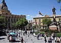
Plaza Murillo with Government and Legislative Palaces in the background
-
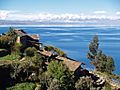
Titicaca Lake near La Paz with the Andes in the background
-
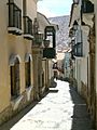
Calle Jaén.
-
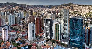
Buildings in La Paz
-
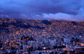
La Paz at night


See also
 In Spanish: La Paz para niños
