
List of non-authentic covered bridges in Vermont facts for kids
Vermont is a state in the United States that has many covered bridges. It actually has the most covered bridges per square mile! Some of these bridges are old and historic, but others are newer. These newer ones are often called "replica" or "non-authentic" covered bridges.
What does "non-authentic" mean? It means they don't use the old, traditional ways of building bridges, like special wooden frames called "trusses." Instead, they often use simpler "stringer construction," which is like using long beams to support the bridge. This list focuses on these newer, non-authentic bridges. Since many of these are built in people's backyards or on private land, this list might not include every single one.
Contents
Finding These Bridges
It's important to know if you can visit these bridges or just see them from a distance.
Public Bridges
Some bridges are truly open to everyone. You might find them in parks, at hotels, or near stores. These are marked as "Public." You can usually get close to these bridges without any problems.
Private Bridges
Other bridges are on private property. These are marked as "Private." Even if visitors are sometimes allowed, it's best to check first. We'll try to let you know if you can at least see the bridge from a public road without going onto private land.
Bridge Locations
We've included GPS coordinates for many bridges. These are like digital addresses that tell you exactly where a bridge is located using latitude and longitude.
List of Non-Authentic Covered Bridges
Here is a list of some of the non-authentic covered bridges you can find in Vermont.
| Name | County | Location | Built | Length (ft) | Crosses | Access | Coordinates | Photo | Notes |
|---|---|---|---|---|---|---|---|---|---|
| Hemingway | Addison | Granville | 1973 | 20' | unknown stream | Private | |||
| Casey | Addison | Starksboro | 1991 | 16' | Baldwin Brook | Private | |||
| Gilley | Addison | Starksboro | 1991 | 12' | unknown brook | Private | |||
| Little Otter Creek | Addison | Ferrisburgh | 1973 | 16' | Little Otter Creek | Private | 44°10′46.2″N 73°11′43.8″W / 44.179500°N 73.195500°W | ||
| Heath | Addison | Waltham | ? | 11' | pond outlet | Private | 44°08′35″N 73°13′20″W / 44.14306°N 73.22222°W | ||
| Kreffer Crossing | Bennington | Sandgate | 1976 | 39' | Green River on Sandgate Road | Private | |||
| Grace Christian School | Bennington | Bennington | 1979 | 30' | Furnace Brook | Public | 42°53′42″N 73°11′54″W / 42.89500°N 73.19833°W | ||
| Armstrong | Bennington | Bennington | 1985 | 40' | Jewett Brook | Private | |||
| Gregory | Bennington | Manchester | ? | 30' | Unknown brook | Private | |||
| Bennington Covered Bridge Museum | Bennington | Bennington | 2003 | ? | on dry land | Public | This bridge is at a covered bridge museum. We need to check if it's built in the old, authentic way. | ||
| Bondville Fair | Bennington | Winhall | 2004 | 24' | on dry land | Public | This "bridge" uses a Town lattice design, but it doesn't have a floor. So, is it really a bridge? | ||
| Jeudevine Falls | Caledonia | Hardwick | 2001 | 24' | brook | Private | 44°32′56″N 72°22′19″W / 44.548796°N 72.371911°W | ||
| Joe's Pond | Caledonia | West Danville | 1977 | 37' | outlet of Joe's Pond | Public | 44°24′30″N 72°11′42″W / 44.40833°N 72.19500°W | ||
| Riverside Park | Chittenden | Jericho | 1972 | 37' | Browns River | Public | 44°30′59″N 72°56′48″W / 44.51639°N 72.94667°W | ||
| LaRue | Chittenden | Underhill | 1982 | 40' | Browns River | Private | 44°31′01″N 72°55′38″W / 44.51694°N 72.92722°W | ||
| Circus Building | Chittenden | Shelburne | ? | 21' | on a path | Public | This bridge is at the Shelburne Museum, which requires paid admission. | ||
| Potbin | Chittenden | Underhill | ? | 8' | pond outlet | Private | |||
| P&S Country Furniture Barn | Essex | Concord | c1980 | 18' | pond outlet | Public | 44°26′40″N 71°55′04″W / 44.44444°N 71.91778°W | ||
| Jackson | Essex | Lemington | c1970 | 16' | Jones Brook | Private | |||
| Nelson | Essex | Lunenburg | 1990 | 16' | unknown brook | Private | |||
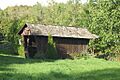
| Beebe | Franklin | St. Albans | 1968 | 17' | pond outlet | Private | 44°47′36″N 73°02′43″W / 44.79333°N 73.04528°W | You can see this bridge from the road. | |
| Mediaway | Franklin | Montgomery | 1981 | 25' | unknown brook | Public(?) | 44°53′07″N 72°32′23″W / 44.88528°N 72.53972°W | This bridge seems to be at a business and is visible from the road. | |
| Sylvester | Franklin | Montgomery | 2000 | 14' | pond outlet | Private | 44°52′53″N 72°39′32″W / 44.881497°N 72.658795°W | This bridge is fairly close to the road. | |
| Blondin | Franklin | Montgomery | 1996 | 24' | pond outlet | Private | 44°52′28″N 72°39′29″W / 44.87444°N 72.65806°W | You might be able to take a picture from the road with a special camera lens. | |
| Homestead | Franklin | Franklin | 1993 | 17' | unknown brook | Private | |||
| Pont De Columb Un | Franklin | Franklin | 2001 | 16' | unknown brook | Private | 44°59′57″N 72°56′22″W / 44.99917°N 72.93944°W | We're not sure which of these two bridges is "Un" (one) and which is "Deux" (two). | |
| Pont De Columb Deux | Franklin | Franklin | 2001 | 16' | unknown brook | Private | 44°59′56″N 72°56′21″W / 44.99889°N 72.93917°W | Both bridges can be seen from the road on the same property. | |
| Granger | Franklin | Franklin | 1972 | 16' | unknown brook | Private | |||
| Pattees | Franklin | Enosburg | 1979 | 22' | unknown brook | Private | 44°51′53.1″N 72°45′44.5″W / 44.864750°N 72.762361°W | You might be able to take a picture from the road with a special camera lens. | |
| Edward's | Lamoille | Belvidere | ? | ? | brook | Private | 44°44′14″N 72°44′09″W / 44.737185°N 72.735929°W | ||
| White Caps | Lamoille | Stowe | 1970 | 56' | West Branch of Waterbury River on Brook Road | Public | 44°29′50″N 72°44′43″W / 44.497104°N 72.745314°W | This bridge is at the entrance to a neighborhood. It has a concrete deck but uses special Howe trusses to support its weight. | |
| Sidewalk | Lamoille | Stowe | 1973 | 150' | Waterbury River on Vermont Route 108 | Public | 44°27′59″N 72°41′17″W / 44.46639°N 72.68806°W | ||
| unknown | Lamoille | Stowe | ? | ? | unknown brook | Private | 44°28′59″N 72°39′49″W / 44.483134°N 72.663622°W | ||
| Mountain Road Motel | Lamoille | Stowe | 1975 | 15' | unknown brook | Public | 44°28′23″N 72°41′56″W / 44.473172°N 72.698845°W | ||
| Morse Mill | Lamoille | Cambridge | 1988 | 45' | Brewster River | Private | 44°35′18.3″N 72°47′28.8″W / 44.588417°N 72.791333°W | You can see this bridge from the road. | |
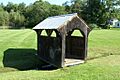
| Lynch & Burt | Lamoille | Waterville | 1992 | 12' | unknown brook on Village Green | Public | 44°41′22.5″N 72°46′8.1″W / 44.689583°N 72.768917°W | ||
| Adair | Lamoille | Waterville | 1987 | 17' | pond inlet | Private | |||
| Gentle Giants Sleigh & Carriage Rides | Lamoille | Stowe | ? | ? | swampy area | Public | 44°29′35″N 72°44′29″W / 44.49314°N 72.741366°W | ||
| Golden Eagle Resort #1 | Lamoille | Stowe | ? | 8' | unknown brook | Public | |||
| Golden Eagle Resort #2 | Lamoille | Stowe | 1999 | 12' | unknown brook | Public | |||
| Weltman | Lamoille | Morristown | 1972 | 32' | Sterling Brook | Private | |||
| Faith | Lamoille | Waterville | 1998 | 10' | pond outlet | Private | 44°41′11″N 72°46′10″W / 44.68639°N 72.76944°W | You can see this bridge from the road. | |
| Kneeland Beauty Salon | Lamoille | Hyde Park | ? | 10' | Unknown brook | Public | |||
| Braley | Orange | Tunbridge | 1990 | 20' | artificial pond | Private | 43°55′19″N 72°24′31″W / 43.92194°N 72.40861°W | You might be able to take a picture with a special camera lens. This is not the same as the historic Braley Covered Bridge. | |
| Roystan | Orange | Newbury | 1996 | 21' | unnamed brook | Private | |||
| unknown | Orange | Newbury | ? | ? | unnamed brook | Private | 44°05′32″N 72°05′35″W / 44.092228°N 72.093074°W | ||
| Driscoll | Orange | Fairlee | ? | 8' | pond | Private | |||
| English Rose Inn | Orleans | Westfield | 1973 | 14' | pond outlet | Public | 44°53′16.5″N 72°32′8.6″W / 44.887917°N 72.535722°W | ||
| Auger Sugarmill | Orleans | Barton | 1988 | 40' | Barton River | Private | 44°43′43″N 72°11′11″W / 44.72861°N 72.18639°W | This bridge is on a private road, but you might be able to get close. | |
| St. Onge | Orleans | Lowell | 1988 | 32' | ditch | Private | |||
| Quesnell | Orleans | Lowell | 1999 | 8' | ditch | Private | 44°46′25″N 72°27′25.4″W / 44.77361°N 72.457056°W | This bridge is easy to see from the side of the road. | |
| Neshobe Golf Club | Rutland | Brandon | 1986 | 39' | Neshobe River | Public | 43°48′39.5″N 73°04′28″W / 43.810972°N 73.07444°W | You can see this bridge from the road. You might be able to walk onto the golf course to get closer. | |
| Borrelli | Rutland | Mount Holly | ? | 16' | pond | Private | |||
| Pat Bailey | Rutland | Pittsford | 2014 | ? | pond | Public | This bridge is at the New England Maple Museum. | ||
| Getzinger | Washington | Moretown | ? | ? | unknown brook | Private | 44°13′20″N 72°42′39″W / 44.222345°N 72.710795°W | ||
| Battleground | Washington | Fayston | 1974 | 51' | Mill Brook | Public | 44°12′03″N 72°53′42″W / 44.20083°N 72.89500°W | This bridge is at the entrance to a group of homes. | |
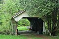
| Chamberlin | Washington | Northfield | 1956 | 19' | tributary of Stony Brook | Private | 44°08′55″N 72°43′05.5″W / 44.14861°N 72.718194°W | This bridge is easy to see close to the road. It is not the same as the historic Chamberlin Covered Bridge. | |
| Best Western | Washington | Waterbury | 1962 | 50' | mountain stream | Public | 44°20′43″N 72°44′59.2″W / 44.34528°N 72.749778°W | ||
| Floyd Fitch #1 | Washington | Calais | 1962 | 10' | Pekin Brook | Private | |||
| Floyd Fitch #2 | Washington | Calais | 1984 | 12' | Pekin Brook | Private | |||
| Rea | Washington | Calais | 1992 | 13' | ditch | Private | |||
| Santa's Sweetheart | Windham | Putney | 1957 | 29' | unnamed brook | Public | This bridge is at Santa's Land theme park. | ||
| Santa's Land Railroad | Windham | Putney | 1962 | 18' | unnamed brook | Public | This bridge is at Santa's Land theme park. | ||
| Santa's Land Swan | Windham | Putney | 1990 | 19' | unnamed brook | Public | This bridge is at Santa's Land theme park. | ||
| Covered Bridge Lodge | Windham | Dover | 1964 | 38' | Blue Brook | Private | You can see this bridge from the road. | ||
| Grafton Cheese Factory | Windham | Grafton | 1967 | 62' | South Branch Saxtons River | Public | 43°09′59″N 72°36′47″W / 43.16639°N 72.61306°W | ||
| Great American Recreation Cafe | Windham | Wilmington | 1977 | 34' | Bill Brook | Public | 42°54′32″N 72°50′50″W / 42.90889°N 72.84722°W | ||
| Island Properties | Windham | Jamaica | 1989 | 62' | West River | Private? | 43°05′23.5″N 72°46′05.5″W / 43.089861°N 72.768194°W | This bridge used to be the entrance to a group of homes that now seems empty. It might be a private road now. | |
| John Tyler Sherwin | Windham | Brattleboro | 1988 | 16' | drainage ditch | Public | This bridge is at Living Memorial Park. | ||
| Dummerston School | Windham | Dummerston | 1994 | 12' | ditch | Public | |||
| Chase | Windham | Brattleboro | 1962 | 16' | unknown brook | Private | |||
| Snow | Windham | Stratton | 1998 | 62' | ski trail | Public | 43°06′40″N 72°55′00″W / 43.11111°N 72.91667°W | This bridge is at the entrance to a group of homes. | |
| Hermitage Road | Windham | Dover | 2009 | 50' | Cold Brook | Public | 42°55′42″N 72°53′20″W / 42.92833°N 72.88889°W | ||
| Kindle Farm School | Windham | Townshend | 2006 | 17' | ditch | Public | 43°01′11″N 72°39′27.5″W / 43.01972°N 72.657639°W | ||
| Noway Farm | Windsor | Barnard | 1981 | 13' | Gulf Stream | Private | |||
| Seven Cedars Farm | Windsor | Barnard | 1985 | 24' | Pond Brook | Private | 43°45′14″N 72°37′58″W / 43.75389°N 72.63278°W | ||
| Quechee | Windsor | Hartford | 1970 | 85' | Ottauquechee River on Waterman Hill Road | Public | 43°38′44″N 72°25′09″W / 43.645427°N 72.419059°W | This bridge uses steel beams for support. It was rebuilt in 2013 after a big storm called Hurricane Irene damaged it. | |
| Mill Brook | Windsor | Reading | 2009 | 59' | Mill Brook | Private | 43°28′57″N 72°33′05″W / 43.48243°N 72.551485°W | ||
| Green Mountain Horse Association | Windsor | Woodstock | 1998 | 6' | dry land | Public |


Bridges That Are No Longer Here
Some covered bridges that were once on this list are now gone.
Lost to Hurricane Irene
The following bridges were thought to be destroyed by Hurricane Irene on August 28, 2011:
- Giorgetti Covered Bridge (used to be in Pittsfield)
- Toll Covered Bridge (used to be in Dover)
- Pickle Barrel Covered Bridge (used to be in Sherburne)
- Spring Hill Farm Covered Bridge (used to be in Barnard)
- Seven Cedars Farm (used to be in Barnard)
However, the Giorgetti and Pickle Barrel covered bridges were not destroyed by Hurricane Irene. They are still standing today!
Other Bridges No Longer Standing
- The Hayes Covered Bridge, which was in Brookline, was removed in November 2010 because it was rotting.
- The Deer Park Covered Bridge, which was in Bennington, is also reportedly gone.
See also
- List of covered bridges in Vermont
- List of bridges on the National Register of Historic Places in Vermont
- List of Vermont-related topics
Images for kids
-
Beebe Covered Bridge
-
Lynch & Burt Covered Bridge
-
Chamberlin Covered Bridge
