Geography of Nevada facts for kids
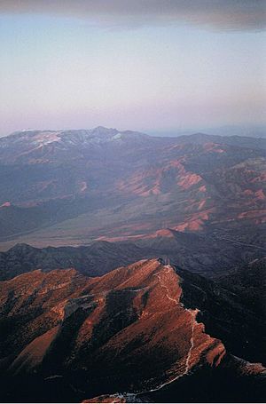
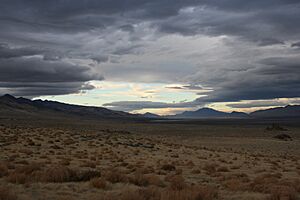
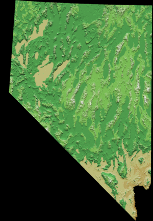
Nevada is a state in the western United States that does not touch the ocean. Its land is very diverse, with many north-south mountain ranges. Most of these ranges have valleys between them where water collects but doesn't flow out to the ocean. This type of valley is called an endorheic basin.
Contents
Nevada's Landscape and Features
Much of northern Nevada is part of the Great Basin. This is a mild desert that gets very hot in summer and very cold in winter. Sometimes, summer thunderstorms happen because of moisture from the Arizona Monsoon. Pacific storms can also bring snow to the area. The hottest temperature ever recorded in Nevada was 125°F (52°C) in Laughlin in 1994. The coldest was -52°F (-47°C) in San Jacinto in 1972.
The Humboldt River flows across the northern part of the state from east to west. It ends in the Humboldt Sink near Lovelock. Other rivers, like the Walker, Truckee, and Carson rivers, flow east from the Sierra Nevada mountains. All these rivers also end in lakes or dry lakebeds, like Walker Lake and Pyramid Lake. This means their water doesn't reach the ocean.
However, not all of Nevada is part of the Great Basin. Rivers that flow into the Snake River drain the far north. The Colorado River forms much of the border with Arizona and drains southern Nevada.
Nevada's mountains can be very tall, with some peaks over 13,000 feet (4,000 meters) high. These high mountains have green forests, which are like "sky islands" in the middle of the desert plains. They are home to special plants and animals found only there. The valleys are usually at least 3,000 feet (900 meters) high, and some in central Nevada are even above 6,000 feet (1,800 meters).
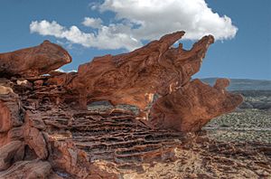
The southern part of Nevada, where Las Vegas is located, is in the Mojave Desert. This area gets less rain in winter but more from the Arizona Monsoon in summer. The land is also lower, mostly below 4,000 feet (1,200 meters). This leads to very hot summer days and cool winter nights.
Nevada shares a very long, straight border with California, stretching over 400 miles (640 km). This line starts in Lake Tahoe and goes all the way to the Colorado River.
The largest mountain range in southern Nevada is the Spring Mountain Range, located west of Las Vegas. The lowest point in the state is along the Colorado River, south of Laughlin.
Nevada has 172 mountain peaks that rise at least 2,000 feet (610 meters) above their surroundings. This makes Nevada second in the U.S. for the number of prominent mountains, right after Alaska.
Nevada's Climate

Nevada is the driest state in the United States. Most of it has a desert or semi-dry climate. Except for the Las Vegas Valley, the temperature difference between day and night in summer can be almost 40°F (22°C). Winters in northern Nevada are long and cold. But in the southern part of the state, winters are short and mild.
Most of Nevada gets very little rain each year. The average rainfall is about 7 inches (178 mm). The wettest areas, like the eastern slopes of the Sierra Nevada, can get around 40 inches (1,000 mm). Nevada's record high temperature of 125°F (52°C) is the third highest ever recorded in a U.S. state.
Average Temperatures in Nevada Cities
| Location | July (°F) | July (°C) | December (°F) | December (°C) | ||||
|---|---|---|---|---|---|---|---|---|
| Max | Min | Max | Min | Max | Min | Max | Min | |
| Las Vegas | 106 | 81 | 41 | 27 | 56 | 38 | 13 | 3 |
| Reno | 92 | 57 | 33 | 14 | 45 | 25 | 7 | –4 |
| Carson City | 89 | 52 | 32 | 11 | 45 | 22 | 7 | –5 |
| Elko | 90 | 50 | 32 | 10 | 37 | 14 | 2 | –9 |
| Fallon | 92 | 54 | 33 | 12 | 45 | 19 | 7 | –7 |
| Winnemucca | 93 | 52 | 34 | 11 | 41 | 17 | 5 | –8 |
| Laughlin | 112 | 80 | 44 | 27 | 65 | 43 | 18 | 6 |
Plants and Animals of Nevada
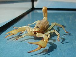
Since Nevada is the driest U.S. state and has large deserts like the Great Basin Desert and the Mojave Desert, most of its plants and animals are able to live in a desert environment. They have special ways to survive with little water.
Even so, Nevada's natural world is very diverse. It has six main types of natural areas, called biotic zones. These include high mountain areas (alpine), slightly lower mountain areas (sub-alpine), ponderosa pine forests, pinion-juniper woodlands, sagebrush areas, and creosotebush areas.
Nevada is home to many different creatures:
- 488 types of birds, such as bald eagles and mountain bluebirds.
- 61 types of mammals, like desert bighorn sheep and coyotes.
- 16 types of scorpions.
- 52 types of reptiles, including Great Basin rattlesnakes and desert tortoise.
- 48 types of fish, such as Lahontan cutthroat trout and mountain whitefish.
Nevada's Government and Areas
Counties of Nevada

Nevada is divided into areas called counties. Carson City is special because it acts as both a city and a county. In 1919, Nevada had 17 counties. Their sizes ranged from 146 to 18,159 square miles (378 to 47,000 sq km).
One of the first counties, Lake County (formed in 1861), was renamed Roop County in 1862. Part of it later became part of California. In 1883, the rest of Roop County became part of Washoe County.
In 1969, Ormsby County was changed. The Consolidated Municipality of Carson City was created in its place, covering the same area.
A county called Bullfrog County was created in 1987 from part of Nye County. But it was later found to be against the law and was removed in 1989.
Humboldt County was first named a county in 1856 by the Utah government. Then it was named again in 1861 by the new Nevada government.
Clark County has the most people in Nevada. Almost three-quarters of the state's residents live there. Las Vegas, Nevada's biggest city, has been the main city (county seat) of Clark County since it was created in 1909. Before that, it was part of Arizona. Clark County is very popular with tourists. About 44 million people visited Clark County in 2014.
Washoe County is the second most populated county in Nevada. Its main city is Reno. Washoe County includes the Reno–Sparks area, which is a large city area.
Lyon County is the third most populated county. It was one of the first nine counties created in 1861. It was named after Nathaniel Lyon, a general who died in the American Civil War. Its current main city is Yerington.
| County name | County seat | Year founded | 2021 population | Percent of total | Area (mi2) | Percent of total | Population density (/mi2) |
|---|---|---|---|---|---|---|---|
| Carson City | Carson City | 1861 | 58,993 | 1.88 % | 157 | 0.14 % | 407.80 |
| Churchill | Fallon | 1861 | 25,723 | 0.82 % | 5,024 | 4.54 % | 5.22 |
| Clark | Las Vegas | 1908 | 2,292,476 | 72.92 % | 8,061 | 7.29 % | 290.52 |
| Douglas | Minden | 1861 | 49,870 | 1.59 % | 738 | 0.67 % | 70.24 |
| Elko | Elko | 1869 | 53,915 | 1.71 % | 17,203 | 15.56 % | 3.14 |
| Esmeralda | Goldfield | 1861 | 743 | 0.02 % | 3,589 | 3.25 % | 0.21 |
| Eureka | Eureka | 1869 | 1,903 | 0.06 % | 4,180 | 3.78 % | 0.46 |
| Humboldt | Winnemucca | 1856/1861 | 17,648 | 0.56 % | 9,658 | 8.73 % | 1.83 |
| Lander | Battle Mountain | 1861 | 5,734 | 0.18 % | 5,519 | 4.99 % | 1.04 |
| Lincoln | Pioche | 1867 | 4,525 | 0.14 % | 10,637 | 9.62 % | 0.43 |
| Lyon | Yerington | 1861 | 60,903 | 1.94 % | 2,024 | 1.83 % | 30.44 |
| Mineral | Hawthorne | 1911 | 4,586 | 0.15 % | 3,813 | 3.45 % | 1.22 |
| Nye | Tonopah | 1864 | 53,450 | 1.70 % | 18,199 | 16.46 % | 2.94 |
| Pershing | Lovelock | 1919 | 6,741 | 0.21 % | 6,067 | 5.49 % | 1.12 |
| Storey | Virginia City | 1861 | 4,143 | 0.13 % | 264 | 0.24 % | 15.75 |
| Washoe | Reno | 1861 | 493,392 | 15.69 % | 6,542 | 5.92 % | 78.29 |
| White Pine | Ely | 1869 | 9,182 | 0.29 % | 8,897 | 8.05 % | 1.03 |
| Totals | Counties: 17 | 3,143,991 | 110,572 | 28.64 |
Major Cities and Towns
| Rank | Name | Pop. |
|---|---|---|
| 1 | Las Vegas | 641,903 |
| 2 | Henderson | 317,610 |
| 3 | Reno | 264,165 |
| 4 | North Las Vegas | 262,527 |
| 5 | Enterprise | 221,831 |
| 6 | Spring Valley | 215,597 |
| 7 | Sunrise Manor | 205,618 |
| 8 | Paradise | 191,238 |
| 9 | Sparks | 108,445 |
| 10 | Carson City | 58,639 |
 | Georgia Louise Harris Brown |
 | Julian Abele |
 | Norma Merrick Sklarek |
 | William Sidney Pittman |


