
Montgomery County, Maryland facts for kids
Quick facts for kids
Montgomery County, Maryland
|
|||||
|---|---|---|---|---|---|
| County of Montgomery | |||||
      Clockwise: Downtown Bethesda, Spring Street in Silver Spring, Billy Goat B Trail, rural Darnestown, Rockville town center, Great Falls on the Potomac River
|
|||||
|
|||||
| Nickname(s):
"MoCo"
|
|||||
| Motto(s):
French: Gardez Bien (English: Watch Well)
|
|||||

Location in the U.S. state of Maryland
|
|||||
| Country | United States | ||||
| State | Maryland | ||||
| Seat | Rockville | ||||
| Largest community | Germantown | ||||
| Founded | September 6, 1776 | ||||
| Named for | Richard Montgomery | ||||
| Area | |||||
| • Total | 506.91 sq mi (1,312.89 km2) | ||||
| • Land | 493.11 sq mi (1,277.15 km2) | ||||
| • Water | 13.80 sq mi (35.74 km2) | ||||
| Population
(2020)
|
|||||
| • Total | 1,062,061 |
||||
| • Density | 2,153.80/sq mi (831.59/km2) | ||||
| Demonyms | Montgomery Countyan, MoCoite | ||||
| Gross Domestic Product | |||||
| • Total | $106.7 billion (2022) | ||||
| Time zone | UTC−05:00 (Eastern [EST]) | ||||
| • Summer (DST) | UTC−04:00 (EDT) | ||||
| ZIP Codes |
20812–20918
|
||||
| Area codes |
|
||||
| Congressional districts | 4th, 6th, 8th | ||||


Montgomery County is the most populated county in the U.S. state of Maryland. In 2020, over 1 million people lived here. The county seat, or main government town, is Rockville. Germantown is the largest community.
The county is right next to Washington, D.C., the nation's capital. It's part of the larger Washington metropolitan area. Many residents live in Silver Spring, Bethesda, Germantown, and the cities of Rockville and Gaithersburg.
Montgomery County is known for having a high average household income. It also has many people over 25 with advanced college degrees. You'll find several U.S. government offices, scientific research centers, and big business campuses here.
Contents
- What's in a Name?
- A Look Back: History of Montgomery County
- Exploring Montgomery County's Geography
- Weather and Climate
- Who Lives in Montgomery County?
- Economy: How People Make a Living
- Getting Around: Transportation
- Learning and Education
- Culture and Fun
- Communities in Montgomery County
- Images for kids
- See also
What's in a Name?
.png)
.png)
Montgomery County was named after Richard Montgomery. He was a general in the American Revolutionary War. The county was formed from parts of Frederick County on September 6, 1776. This was a big deal because it was one of the first times in American history that a county was not named after someone British. This showed defiance against Great Britain during the war.
The county's nickname, "MoCo," is a short way of saying "Montgomery County." People started using it around 2001.
The county's motto is "Gardez Bien," which is French for "Watch Well." This motto was adopted in 1976 and is also the motto of General Montgomery's family.
A Look Back: History of Montgomery County
The land that is now Montgomery County was first given away by King Charles I in 1688. He gave it to the first Lord Baltimore, George Calvert.
The idea to create Montgomery County came from Thomas S. Wootton in 1776. He wanted to form a new county from Frederick County, Maryland. This would make it easier for people in the area to handle their business. His idea passed, and Montgomery County became a new political area in the colonial Province of Maryland.
Exploring Montgomery County's Geography
Montgomery County covers about 507 square miles. Most of this is land, with a small part being water. The county is located on the Piedmont plateau, which means it has rolling hills. The land goes from almost sea level near the Potomac River to about 875 feet high in the northern part of the county.
The county's border was set in 1776. It starts at Rock Creek on the Potomac River and goes to the Monocacy. Then it follows a straight line to a place called Parr's Spring.
Neighboring Counties
Montgomery County shares borders with several other counties and a major city:
- Frederick County (to the northwest)
- Carroll County (to the north)
- Howard County (to the northeast)
- Prince George's County (to the southeast)
- Washington, D.C. (to the south)
- Fairfax County, Virginia (to the southwest)
- Loudoun County, Virginia (to the west)
National Parks and Sites
Parts of these national protected areas are in Montgomery County:
- Chesapeake and Ohio Canal National Historical Park
- Clara Barton National Historic Site
- George Washington Memorial Parkway
Weather and Climate
Montgomery County has a humid subtropical climate. This means it has four clear seasons. Summers are hot and humid, while winters are cool.
Rainfall is spread out throughout the year, with about 43 inches of rain annually. Thunderstorms are common in the summer. Heavy rain often comes with these summer storms.
The average yearly temperature is about 55 degrees Fahrenheit. In summer (June-August), the average high is around 85°F, and the low is about 66°F. In winter (December-February), the average high is 44°F, and the low is 28°F. Sometimes, it can get very hot, over 100°F, or very cold, below 0°F.
Snowfall varies across the county. Southern areas like Silver Spring get about 17.5 inches of snow each year. Northern areas like Damascus get more, about 21.3 inches.
Who Lives in Montgomery County?
| Historical population | |||
|---|---|---|---|
| Census | Pop. | %± | |
| 1790 | 18,003 | — | |
| 1800 | 15,058 | −16.4% | |
| 1810 | 17,980 | 19.4% | |
| 1820 | 16,400 | −8.8% | |
| 1830 | 19,816 | 20.8% | |
| 1840 | 15,456 | −22.0% | |
| 1850 | 15,860 | 2.6% | |
| 1860 | 18,322 | 15.5% | |
| 1870 | 20,563 | 12.2% | |
| 1880 | 24,759 | 20.4% | |
| 1890 | 27,185 | 9.8% | |
| 1900 | 30,451 | 12.0% | |
| 1910 | 32,089 | 5.4% | |
| 1920 | 34,921 | 8.8% | |
| 1930 | 49,206 | 40.9% | |
| 1940 | 83,912 | 70.5% | |
| 1950 | 164,401 | 95.9% | |
| 1960 | 340,928 | 107.4% | |
| 1970 | 522,809 | 53.3% | |
| 1980 | 579,053 | 10.8% | |
| 1990 | 757,027 | 30.7% | |
| 2000 | 873,341 | 15.4% | |
| 2010 | 971,777 | 11.3% | |
| 2020 | 1,062,061 | 9.3% | |
| 2023 (est.) | 1,058,474 | 8.9% | |
| U.S. Decennial Census 1790–1960 1900–1990 1990–2000 2010 2020 |
|||
Since the 1970s, Montgomery County has had a special plan called the Moderately Priced Dwelling Unit (MPDU) zoning plan. This plan requires builders to include affordable housing in new neighborhoods. The goal is to mix different income levels in neighborhoods and schools. This way, people of all backgrounds can live and learn together.
Montgomery County is one of the most diverse counties in the United States. Four of the ten most culturally diverse cities and towns in the U.S. are in Montgomery County: Gaithersburg, Germantown, Silver Spring, and Rockville. These places are even more diverse than big cities like New York City!
Population Facts
In 2020, the county's population was 1,062,061 people.
- About 40.6% were White (not Hispanic).
- About 18.2% were Black or African American (not Hispanic).
- About 15.3% were Asian (not Hispanic).
- About 20.5% were Hispanic or Latino (of any race).
Many people from Central and South America live in Montgomery County. For example, over 52,000 people of Salvadoran descent live here.
Economy: How People Make a Living
Montgomery County is a major center for business and research. It's especially important for biotechnology in the Mid-Atlantic region. This means there are many companies that work with living things to create new products or solve problems.
Important places for Biomedical research include Johns Hopkins University's Montgomery County Campus and the Howard Hughes Medical Institute. Many U.S. government agencies also do related work here, such as the Food and Drug Administration (FDA) and the National Institutes of Health (NIH).
Many large companies have their headquarters in the county. These include Lockheed Martin, Marriott International, and GEICO. Other government agencies like the National Oceanic and Atmospheric Administration (NOAA) and the Nuclear Regulatory Commission (NRC) are also based here.
Downtown Bethesda and Silver Spring are the biggest business areas in the county. They are very busy, like major city centers.
Top Employers in Montgomery County
Many organizations employ a large number of people in the county. Here are some of the top employers:
- U.S. Department of Health and Human Services
- Montgomery County Public Schools
- Montgomery County Government
- U.S. Department of Defense
- Adventist Healthcare
- Holy Cross Hospital of Silver Spring
- Marriott International Administrative Services
- Montgomery College
- GEICO
- U.S. Department of Commerce
Getting Around: Transportation
_from_the_overpass_for_West_Gude_Drive_in_Rockville,_Montgomery_County,_Maryland.jpg)
In the early 1700s, it was hard for farmers in Montgomery County to get their crops to market because there weren't good roads. The first roads were built by the 18th century, but they were often not very good.
One early road, Maryland Route 355, connected Frederick and Georgetown. The county's first paved road, a turnpike, was finished in 1828. It ran from Georgetown to Rockville.
The United States Army Corps of Engineers built the Washington Aqueduct from 1853 to 1864. This brought water from Great Falls to Washington. The road built over the aqueduct is now called MacArthur Boulevard.
Major Roads and Highways
Montgomery County has many important roads and highways, including:
 I-270
I-270 I-495 (the Capital Beltway)
 US 29
US 29 MD 97
MD 97 MD 355
Bus Services
Montgomery County has its own bus system called Ride On. There is also the Metrobus service from WMATA, which covers major routes near the rail lines.
The county started building a bus rapid transit (BRT) system in 2018. This system has special lanes for buses to move faster. It has been running between Silver Spring and Burtonsville since 2020. More routes are planned for the future.
Train Services
Montgomery County has several passenger train systems:
- Amtrak: The national passenger rail system stops in Rockville.
- MARC Train: This commuter train system has many stops throughout the county, connecting towns like Silver Spring, Rockville, and Germantown.
- Washington Metro's Red Line: This subway system serves many parts of the county, connecting to Washington, D.C.
A new light rail system called the Purple Line is currently being built. It will connect Montgomery and Prince George's Counties and is expected to open in 2026. It will have 21 stations and connect to existing Metro and MARC train stations.
Airports
The main airport in the county is the Montgomery County Airpark in Gaithersburg. It's a general aviation facility, meaning it's mostly for smaller planes. For commercial flights, people use nearby airports like Ronald Reagan Washington National, Washington Dulles International, and BWI Airports.
Learning and Education
Education in Montgomery County is provided by Montgomery County Public Schools, Montgomery College, and other schools.
Montgomery County Public Schools
The public elementary and secondary schools are run by Montgomery County Public Schools (MCPS). This is the largest school district in Maryland. It serves about 162,000 students and has many teachers and staff.
MCPS is managed by an elected board of education. The school system works to protect student information. They even have a "data deletion week" to remove unnecessary student data from their systems.
Montgomery College
The county also has Montgomery College. This is a public community college that is open to everyone. While the county doesn't have its own public university, the state university system has a facility in Rockville called Universities at Shady Grove. Here, students can take college and Master's level programs from several state universities.
Montgomery County Public Libraries
The Montgomery County Public Libraries (MCPL) system has 23 different libraries. They offer many resources for learning and reading to the community.
Culture and Fun

Montgomery County is a very diverse place, including in its religions. In 2023, it was named the most religiously diverse county in the United States! This means people from many different faiths live here.
The Seventh-day Adventist Church has its main headquarters in Silver Spring.
Sports and Recreation
- The Washington Spirit is a professional women's soccer team that used to play its home games at the Maryland SoccerPlex in Boyds. They now play at Audi Field in Washington, D.C.
- Congressional Country Club in Bethesda has hosted major golf championships, including the U.S. Open.
- There are college-level baseball teams like the Bethesda Big Train, Rockville Express, and Silver Spring–Takoma Thunderbolts.
- The Montgomery County Swim League is a popular youth swimming league with many teams across the county.
- King Farm Park in Rockville has a special "Bankshot Playcourt" for basketball. It's designed so that people of all abilities can play together.
Montgomery County Agricultural Fair

Since 1949, the Montgomery County Agricultural Fair has been held every year. It's the largest fair in Maryland and shows off farm life in the county. This week-long event has carnival rides, live animals, entertainment, and lots of food. Visitors can also see amazing entries of baked goods, clothing, quilts, and produce from local farmers.
Sister Cities
Montgomery County has special "sister city" agreements with places around the world. These agreements help build friendships and understanding between different cultures.
- Morazán Department, El Salvador
- Gondar, Ethiopia
- Xi'an, China
- Hyderabad, India
- Daejeon, South Korea
Communities in Montgomery County
Montgomery County has different types of communities: cities, towns, and villages.
Cities


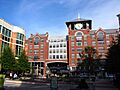
.jpg)

- Gaithersburg
- Rockville (This is the county seat, where the main government offices are.)
- Takoma Park
Towns
- Barnesville
- Brookeville
- Chevy Chase
- Chevy Chase View
- Chevy Chase Village
- Garrett Park
- Glen Echo
- Kensington
- Laytonsville
- Poolesville
- Somerset
- Washington Grove
Villages
- Chevy Chase, Village of, Section 3
- Chevy Chase, Village of, Section 5
- Martin's Additions
- North Chevy Chase
Special Tax Districts
These are areas that are not officially cities or towns, but they have some local services. They might help with things like drainage or street lighting.
Census-Designated Places (CDPs)


These are areas that the U.S. Census Bureau defines for gathering population data. They don't have their own local governments.
- Ashton-Sandy Spring
- Aspen Hill
- Bethesda
- Brookmont
- Burtonsville
- Cabin John
- Calverton (partly in Prince George's County)
- Chevy Chase
- Clarksburg
- Cloverly
- Colesville
- Damascus
- Darnestown
- Fairland
- Forest Glen
- Four Corners
- Germantown
- Glenmont
- Hillandale (partly in Prince George's County)
- Kemp Mill
- Layhill
- Leisure World
- Montgomery Village
- North Bethesda
- North Potomac
- Olney
- Potomac
- Redland
- Silver Spring
- South Kensington
- Travilah
- Wheaton
- White Oak
Unincorporated Communities
These are areas that are not officially part of any city, town, or village.
Images for kids
-

Downtown Bethesda
-
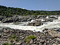
Great Falls on the Potomac River
-
Spring Street in Silver Spring
-
Rockville town center
-
Billy Goat B Trail
-

Rural Darnestown
See also
 In Spanish: Condado de Montgomery (Maryland) para niños
