Santa Clara Valley facts for kids
Quick facts for kids Santa Clara Valley |
|
|---|---|
| Valle de Santa Clara (Spanish) | |
|
Clockwise from the top left:
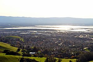
Downtown San Jose skyline; Hillsides in Morgan Hill; Alviso, San Jose; View of Santa Clara Valley; Almaden Reservoir in South San Jose; Stanford University in Stanford. |
|
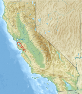
Location in California
|
|
| Length | 90 miles (145 km) northwest–southeast |
| Geography | |
| Location | California, United States |
| Borders on | San Francisco Bay (north), Santa Cruz Mountains (southwest), Diablo Range (east) |
The Santa Clara Valley is a long, narrow valley in Northern California. It stretches about 90 miles (140 km) from San Francisco south to Hollister. Tall mountain ranges border the valley: the Santa Cruz Mountains are to the west, and the Diablo Range is to the east. The northern part of the valley is filled by the San Francisco Bay.
This valley was formed by movements in the Earth's crust. It sits between two major fault lines: the San Andreas Fault on the west and the Hayward and Calaveras faults on the east. Many cities are located here, including parts of San Mateo, Santa Clara, and Alameda counties. The southern part of the valley reaches into San Benito County.
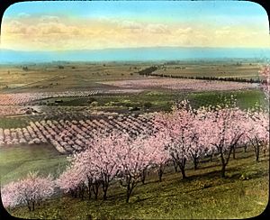
The valley was named after the Spanish Mission Santa Clara. For a long time, it was known as the Valley of Heart's Delight. This was because it had so many fruit orchards, flowering trees, and plants. Until the 1960s, it was the world's biggest fruit-producing area, with many canneries. But starting in the 1960s, new technology companies moved in. This area became known as Silicon Valley. It changed the valley from farms into a busy urban area.
Contents
Exploring Santa Clara Valley
The Santa Clara Valley used to be mostly farmland because of its rich soil. Now, it's mostly cities and towns. However, the far southern parts, south of Gilroy, still have farms. The northern urban areas are part of Silicon Valley. Since Silicon Valley is not a real valley, it also includes parts of the San Francisco Peninsula further north. People often call the urban areas of Santa Clara Valley the South Bay.
You can still find some signs of its farming past. The Santa Clara Valley American Viticultural Area is a large wine-making region. It was one of the first places in California to make wine for sale. They used high-quality grapevines brought from France.
The valley starts at the southern tip of the San Francisco Bay. It ends near Hollister. The Santa Cruz Mountains are to the southwest, separating it from the Pacific Ocean. The Diablo Range is to the northeast. The valley is about 30 miles (50 km) long and 15 miles (20 km) wide. Its biggest city is San Jose, which is much larger than any other city here. About 1.81 million people live in the valley.
The Santa Clara Valley has a Mediterranean climate. This means it has warm, very dry summers and mild, somewhat rainy winters.
Valley History
Mission Santa Clara de Asís was founded in 1777 by Franciscans. It controlled a huge area from Palo Alto to Gilroy. The mission served the Ohlone people. San Jose was also founded in 1777 by Spain as a farming town. It is the oldest town in California. In Spanish and Mexican times, the land was mostly used for raising cattle.
After the Mexican–American War, San Jose was briefly the capital of California. Many native Mexican and Indian people were moved to the mission at Santa Clara. Jesuits took control of the mission in 1850. They founded Santa Clara University there in 1851. By 1860, San Jose had a population of 4,579, and cattle ranching was still the main activity. Wheat became the main crop for a while. But in the 1870s, fruit growing became most important. Drying or canning fruit became the main industry. The railroad reached San Jose in 1860.
The Valley of Heart's Delight
The valley was known as "The Valley of Heart's Delight" because of its beautiful scenery, mild weather, and thousands of acres of blooming fruit trees. Prunes were a major crop and were sent all over the world. Water came from underground sources. When the water level dropped, wells were pumped. Many orchards were small, with homes mixed in with the fruit trees. Famous food brands like Del Monte and Sunsweet started in the Santa Clara Valley.
Many workers were needed for the farms. In the 1800s, Chinese and Japanese immigrants helped with this work. Later, many Italians and other immigrants from Southern and Eastern Europe came to work in the orchards and canneries. In the 1900s, Filipino immigrants and more Mexican immigrants arrived. During World War II, Mexican Americans became the main farm workers. Italians often had experience with growing fruit trees from their home countries and did well.
The Great Depression's Impact
The Great Depression in the 1930s caused big problems for the fruit farms and canneries in the Santa Clara Valley. Prices for fruit dropped very low, and there was too much fruit. Farmers who had lost their homes in the Dust Bowl came to California looking for work. They joined many other people who were also unemployed. Growers could pay very little because prices were so low.
Workers tried to form unions to get better pay and conditions. There were often conflicts between labor organizers and those who opposed unions. Unions like the International Longshore and Warehouse Union (ILWU) supported farm and cannery workers. Some unions, like the Cannery and Agricultural Workers' Industrial Union (CAWIU), had success organizing workers. However, these efforts faced strong opposition and their leaders were sometimes jailed. Over time, cannery workers, including many women, were able to form unions that truly represented them.
War and New Industries
The fruit industry slowly got better. By the early 1940s, the valley was doing well again. World War II brought new industries to the valley. Companies started building things for the war effort. For example, Joshua Hendy Iron Works in Sunnyvale built marine engines. FMC Corporation in Santa Clara built landing craft. An IBM factory in San Jose started making punch cards in 1943.
During the war, about 1,000 Japanese Americans living in the valley were forced to move to special camps. They lost much of their property. Many workers left farms and canneries to work in these new war industries. Mexican Americans from Texas and California, and Mexican braceros (guest workers), took their places. New neighborhoods, like Meadowfair in East San Jose, grew.
After the war, during the Cold War, companies like Lockheed in Sunnyvale built missiles for submarines. Other defense and electronics companies also grew. In the 1950s, the transistor industry began. This, along with research from places like Stanford University, led to the valley becoming Silicon Valley. It became a world leader in electronic technology.
Growth of San Jose
In 1950, A. P. Hamann became the city manager of San Jose. He wanted San Jose to grow much bigger. He started a plan to add more land to the city. San Jose grew from 17 square miles to 136.7 square miles. A key reason for this growth was the city's good sewage system, which was built for cannery waste.
To make sure schools in newly added areas didn't lose money, they were allowed to stay independent. This meant some parts of San Jose, like East San Jose, ended up with schools that had less funding. Other parts of the city had more money for their schools. San Jose's population grew from 95,000 in 1950 to 446,000 in 1970. Some people worried about this fast growth, saying it was too much urban sprawl.
Silicon Valley Today
The Santa Clara Valley is now a very successful center for the global personal computer and internet industries. Making transistors was, and still is, a very important industry here.
Schools in the Valley
Schools in wealthier areas of the Santa Clara Valley often get extra money from private groups. These groups are funded by local residents. Schools in areas with less money have to rely more on state funding.
Cities and Towns in the Valley
Here are some of the cities and towns in the Santa Clara Valley:
- Campbell
- Cupertino
- Gilroy
- Hollister
- Los Gatos
- Los Altos
- Los Altos Hills
- Milpitas
- Monte Sereno
- Morgan Hill
- Mountain View
- Palo Alto
- San Martin
- San Jose
- San Juan Bautista
- Santa Clara
- Saratoga
- Sunnyvale
Some cities like Fremont and Newark are often talked about with Silicon Valley, even though they are not in Santa Clara County. This is because so many high-tech companies are there. Palo Alto is in Santa Clara County and part of Silicon Valley, but it's also on the San Francisco Peninsula.
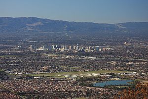
The South Bay Area
The South Bay is a part of the San Francisco Bay Area in California. It mostly refers to the Santa Clara Valley, Silicon Valley, and Santa Clara County. The South Bay is one of several areas in the Bay Area. Other areas include San Francisco, the North Bay, the Peninsula, and the East Bay.
Some cities that are physically separated by the Santa Cruz mountains are also sometimes considered part of this region. These include:
Many other towns are also sometimes included. Cities in the East Bay or on the Peninsula, like Menlo Park, Redwood City, Newark, and Fremont, are often seen as part of Silicon Valley and the South Bay. This is because they are close to Santa Clara County or have many high-tech companies.
Famous Places to See
The South Bay has many well-known buildings and interesting places to visit:
- Apple Park, Cupertino
- Hewlett-Packard, Palo Alto
- Stanford University, Palo Alto
- SAP Center, downtown San Jose
- Hayes Mansion, Southern San Jose
- Plaza de César Chávez, downtown San Jose
- Cathedral Basilica of Saint Joseph, downtown San Jose
- Winchester Mystery House, Western San Jose
- Santana Row, Western San Jose
- Lick Observatory, Mount Hamilton
- Rosicrucian Egyptian Museum, Central San Jose
- Mexican Heritage Plaza, Eastern San Jose
- History Park at Kelley Park, Central San Jose
- Children's Discovery Museum of San Jose, Downtown San Jose
- San Jose International Airport, uptown San Jose
- San Jose Museum of Art, downtown San Jose
- San Jose State University, downtown San Jose
- Santa Clara University, Santa Clara (which includes the original Santa Clara Mission site)
- California's Great America, Santa Clara
- The Tech Interactive, downtown San Jose
- Moffett Federal Airfield, Sunnyvale/Mountain View
- Yahoo!, Sunnyvale
- LinkedIn, Sunnyvale
- Alviso, Northern San Jose (a historic port)
- Berryessa Flea Market, Northern San Jose (once the world's largest)
- Gurdwara Sahib of San Jose, Eastern San Jose (a Sikh Temple)
- Levis Stadium, Santa Clara
How the Valley Was Formed
The Santa Clara Valley was formed by the rapid growth of the Santa Cruz Mountains and the Diablo Range. This happened during a time when the Earth's crust was folding and pushing up, creating mountains. This process, along with active volcanoes, shaped California as we know it today. So, the Santa Clara Valley is a "structural valley," meaning it was created by mountain building, not by erosion (wearing away of the land).
The rocks under the Santa Cruz Mountains were formed from the sediment of ancient seas. You can still find evidence of this today, like shark's teeth and remains of sea life, even high up in places like Scotts Valley. The highest point on the Santa Cruz Mountains side of the valley is Loma Prieta at 3,790 feet. The highest point on the Diablo Range side is Mount Hamilton, specifically Copernicus Peak, at 4,370 feet. This is the highest peak in Santa Clara County.
The valley itself is a graben, which is a sunken block of the Earth's crust. It lies between the San Andreas and Hayward faults.
The Quicksilver Mine
A lot of mercury (also called quicksilver) was taken from the New Almaden mine in the 1800s. This mine was south of San Jose. After mining stopped, the area was bought by Santa Clara County for a park. It was named a National Historic Landmark.
Valley Climate
The Santa Clara Valley has a Mediterranean climate. This means it has warm, very dry summers and mild, fairly rainy winters. The valley gets about 330 sunny days each year.
The northern parts of the valley, like Palo Alto or Mountain View, are closer to the ocean. Their summer temperatures usually stay below 85 °F (29 °C). But in the southern areas and near the mountains, like Los Gatos, Morgan Hill, or Gilroy, summer temperatures often go above 95 °F (35 °C).
Winter is the rainy season, but it's still quite sunny. Winter high temperatures are usually between 57 °F (14 °C) and 66 °F (19 °C). Lows are between 40 °F (4 °C) and 48 °F (9 °C). Summer highs range from 82 °F (28 °C) to 95 °F (35 °C), and summer lows are from 53 °F (12 °C) to 58 °F (14 °C).
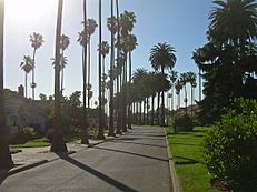
The hottest temperature ever recorded in the Santa Clara Valley was 114 °F (46 °C) in Los Gatos on June 9, 2000. The coldest was 16 °F (−9 °C) in Gilroy on December 23, 1990. Temperatures drop below 40 °F (4 °C) about 17 days a year. They drop below freezing (32°F) about 4 days a year.
Temperatures in the Valley
| Climate data for San Jose, California | |||||||||||||
|---|---|---|---|---|---|---|---|---|---|---|---|---|---|
| Month | Jan | Feb | Mar | Apr | May | Jun | Jul | Aug | Sep | Oct | Nov | Dec | Year |
| Record high °F (°C) | 83 (28) |
85 (29) |
87 (31) |
95 (35) |
101 (38) |
109 (43) |
108 (42) |
105 (41) |
104 (40) |
101 (38) |
85 (29) |
83 (28) |
109 (43) |
| Mean daily maximum °F (°C) | 62 (17) |
65 (18) |
70 (21) |
73 (23) |
77 (25) |
82 (28) |
84 (29) |
84 (29) |
81 (27) |
76 (24) |
65 (18) |
62 (17) |
72.9 (22.7) |
| Mean daily minimum °F (°C) | 43 (6) |
45 (7) |
46 (8) |
48 (9) |
52 (11) |
55 (13) |
57 (14) |
57 (14) |
56 (13) |
52 (11) |
45 (7) |
43 (6) |
49.8 (9.9) |
| Record low °F (°C) | 24 (−4) |
26 (−3) |
30 (−1) |
35 (2) |
37 (3) |
42 (6) |
47 (8) |
47 (8) |
42 (6) |
36 (2) |
21 (−6) |
20 (−7) |
20 (−7) |
| Average precipitation inches (mm) | 3.2 (81) |
2.8 (71) |
2.6 (66) |
1.0 (25) |
0.4 (10) |
0.1 (2.5) |
0.1 (2.5) |
0.1 (2.5) |
0.2 (5.1) |
0.9 (23) |
1.2 (30) |
2.0 (51) |
15.1 (380) |
| Source: AccuWeather.com | |||||||||||||
| Climate data for Campbell, California | |||||||||||||
|---|---|---|---|---|---|---|---|---|---|---|---|---|---|
| Month | Jan | Feb | Mar | Apr | May | Jun | Jul | Aug | Sep | Oct | Nov | Dec | Year |
| Record high °F (°C) | 83 (28) |
86 (30) |
89 (32) |
93 (34) |
98 (37) |
110 (43) |
108 (42) |
106 (41) |
106 (41) |
100 (38) |
86 (30) |
83 (28) |
110 (43) |
| Mean daily maximum °F (°C) | 63 (17) |
66 (19) |
71 (22) |
75 (24) |
79 (26) |
82 (28) |
85 (29) |
85 (29) |
82 (28) |
76 (24) |
66 (19) |
63 (17) |
74 (23) |
| Mean daily minimum °F (°C) | 43 (6) |
46 (8) |
47 (8) |
49 (9) |
52 (11) |
56 (13) |
57 (14) |
57 (14) |
55 (13) |
51 (11) |
46 (8) |
43 (6) |
50 (10) |
| Record low °F (°C) | 22 (−6) |
26 (−3) |
29 (−2) |
35 (2) |
38 (3) |
42 (6) |
42 (6) |
40 (4) |
38 (3) |
36 (2) |
29 (−2) |
19 (−7) |
19 (−7) |
| Average precipitation inches (mm) | 4.7 (120) |
4.1 (100) |
2.6 (66) |
0.6 (15) |
0.3 (7.6) |
0.1 (2.5) |
0.1 (2.5) |
0.1 (2.5) |
0.3 (7.6) |
0.7 (18) |
2.5 (64) |
4.3 (110) |
21.6 (550) |
| Climate data for Los Gatos, California | |||||||||||||
|---|---|---|---|---|---|---|---|---|---|---|---|---|---|
| Month | Jan | Feb | Mar | Apr | May | Jun | Jul | Aug | Sep | Oct | Nov | Dec | Year |
| Record high °F (°C) | 83 (28) |
86 (30) |
89 (32) |
96 (36) |
101 (38) |
114 (46) |
113 (45) |
107 (42) |
109 (43) |
103 (39) |
87 (31) |
83 (28) |
114 (46) |
| Mean daily maximum °F (°C) | 63 (17) |
66 (19) |
72 (22) |
76 (24) |
80 (27) |
84 (29) |
86 (30) |
86 (30) |
84 (29) |
77 (25) |
66 (19) |
63 (17) |
75 (24) |
| Mean daily minimum °F (°C) | 43 (6) |
46 (8) |
47 (8) |
49 (9) |
52 (11) |
56 (13) |
57 (14) |
57 (14) |
55 (13) |
51 (11) |
46 (8) |
43 (6) |
50 (10) |
| Record low °F (°C) | 22 (−6) |
25 (−4) |
28 (−2) |
35 (2) |
37 (3) |
41 (5) |
41 (5) |
40 (4) |
38 (3) |
36 (2) |
28 (−2) |
19 (−7) |
19 (−7) |
| Average precipitation inches (mm) | 4.9 (120) |
4.1 (100) |
2.8 (71) |
0.6 (15) |
0.3 (7.6) |
0.1 (2.5) |
0.1 (2.5) |
0.1 (2.5) |
0.3 (7.6) |
0.7 (18) |
2.8 (71) |
4.8 (120) |
22.8 (580) |
| Climate data for Sunnyvale, California | |||||||||||||
|---|---|---|---|---|---|---|---|---|---|---|---|---|---|
| Month | Jan | Feb | Mar | Apr | May | Jun | Jul | Aug | Sep | Oct | Nov | Dec | Year |
| Record high °F (°C) | 75 (24) |
84 (29) |
85 (29) |
94 (34) |
100 (38) |
107 (42) |
105 (41) |
101 (38) |
105 (41) |
100 (38) |
89 (32) |
75 (24) |
107 (42) |
| Mean daily maximum °F (°C) | 61 (16) |
62 (17) |
64 (18) |
69 (21) |
73 (23) |
77 (25) |
79 (26) |
79 (26) |
78 (26) |
73 (23) |
64 (18) |
61 (16) |
70 (21) |
| Mean daily minimum °F (°C) | 42 (6) |
43 (6) |
46 (8) |
47 (8) |
51 (11) |
55 (13) |
57 (14) |
57 (14) |
55 (13) |
50 (10) |
44 (7) |
42 (6) |
49 (10) |
| Record low °F (°C) | 21 (−6) |
24 (−4) |
22 (−6) |
31 (−1) |
33 (1) |
40 (4) |
41 (5) |
44 (7) |
41 (5) |
34 (1) |
15 (−9) |
20 (−7) |
15 (−9) |
| Average precipitation inches (mm) | 3.24 (82) |
3.18 (81) |
2.65 (67) |
0.89 (23) |
0.35 (8.9) |
0.11 (2.8) |
0.03 (0.76) |
0.08 (2.0) |
0.19 (4.8) |
0.85 (22) |
1.83 (46) |
2.31 (59) |
15.71 (399.26) |
| Source: National Weather Service | |||||||||||||
| Climate data for Mountain View, California | |||||||||||||
|---|---|---|---|---|---|---|---|---|---|---|---|---|---|
| Month | Jan | Feb | Mar | Apr | May | Jun | Jul | Aug | Sep | Oct | Nov | Dec | Year |
| Mean daily maximum °F (°C) | 59 (15) |
63 (17) |
64 (18) |
70 (21) |
73 (23) |
77 (25) |
79 (26) |
79 (26) |
79 (26) |
73 (23) |
64 (18) |
59 (15) |
70 (21) |
| Mean daily minimum °F (°C) | 41 (5) |
43 (6) |
46 (8) |
46 (8) |
52 (11) |
52 (11) |
52 (11) |
52 (11) |
52 (11) |
48 (9) |
45 (7) |
41 (5) |
48 (9) |
| Average precipitation inches (mm) | 3.24 (82.3) |
3.18 (80.8) |
2.65 (67.3) |
0.89 (22.6) |
0.35 (8.9) |
0.11 (2.8) |
0.03 (0.8) |
0.08 (2.0) |
0.19 (4.8) |
0.85 (21.6) |
1.83 (46.5) |
2.31 (58.7) |
15.71 (399.1) |
| Source: http://www.weather.com/outlook/travel/businesstraveler/wxclimatology/monthly/graph/94043?from=text_bottomnav_business#climograph | |||||||||||||
See also
 In Spanish: Valle de Santa Clara para niños
 | Chris Smalls |
 | Fred Hampton |
 | Ralph Abernathy |


