
Brownsville, Brooklyn facts for kids
Quick facts for kids
Brownsville
|
|
|---|---|
|
Neighborhood of Brooklyn
|
|

The Samuel J. Tilden Houses, one of many NYCHA public housing developments located in Brownsville
|
|
| Country | |
| State | |
| City | New York City |
| Borough | Brooklyn |
| Community District | Brooklyn 16 |
| Parceled | 1858 |
| European settlement | 1861 |
| Founded by | William Suydam |
| Named for | Charles S. Brown |
| Area | |
| • Total | 3.01 km2 (1.163 sq mi) |
| Population
(2010)
|
|
| • Total | 58,300 |
| • Density | 19,355/km2 (50,130/sq mi) |
| Economics | |
| • Median income | $31,252 |
| Ethnicity | |
| • White | 3.8% |
| • African American | 68.4% |
| • Hispanic American | 25.6% |
| • Asian/Pacific Islander | 0.9% |
| • Other | 1.3% |
| Time zone | UTC−5 (Eastern) |
| • Summer (DST) | UTC−4 (EDT) |
| ZIP Codes |
11212, 11233
|
| Area codes | 718, 347, 929, and 917 |
Brownsville is a residential neighborhood in eastern Brooklyn in New York City. The neighborhood is generally bordered by Crown Heights to the northwest; Bedford–Stuyvesant and Cypress Hills to the north; East New York to the east; Canarsie to the south; and East Flatbush to the west.
The 1.163-square-mile (3.01 km2) area that comprises Brownsville has 58,300 residents as of the 2010 United States Census. Founded in its current incarnation in 1858, Brownsville was initially a settlement composed of Jewish factory workers. The neighborhood underwent a major demographic change in the 1950s that saw an influx of African-American residents. Since the late 20th century, Brownsville has consistently held one of the highest poverty and crime rates of any neighborhood in New York City.
Brownsville is part of Brooklyn Community District 16, and its primary ZIP Code is 11212. It is patrolled by the 73rd Precinct of the New York City Police Department. Politically it is represented by the New York City Council's 42nd and 41st Districts.
Contents
History
Early development
The area that would become Brownsville was first used by the Dutch for farming, as well as manufacturing stone slabs and other things used to make buildings. In 1823–1824, the Dutch founded the New Lots Reformed Church in nearby New Lots because the corresponding church in Flatbush was too far away. The church, which has its own cemetery that was built in 1841, was listed on the National Register of Historic Places in 1983.
In 1858, William Suydam parceled the land into 262 lots, providing simple two- to four-room accommodations for workers who were living there. However, Suydam vastly underestimated how undesirable the area was, and ran out of funding in 1861. Because he failed to pay mortgages, the land was auctioned off to Charles S. Brown of Esopus, who subdivided the area and began calling it "Brownsville," advertising the area's wide open spaces to Jews who lived in Lower Manhattan. There were 250 houses in "Brown's Village" by 1883, most of them occupied by factory workers who commuted to Manhattan.
In the 1880s, the area was a marshy floodplain that was used as a dumping ground. Fumes from the glue factories along Jamaica Bay would usually blow upwind into Brownsville. This place was inconveniently far enough from Manhattan that the affluent refused to move to Brownsville, but the land was cheap enough that tenements could be built for the poor there.
Jewish neighborhood

Brownsville was predominantly Jewish from the 1880s until the 1950s. In 1887, businessman Elias Kaplan showed the first Jewish residents around Brownsville, painting the area as favorable compared to the Lower East Side, which he described as a place where one could not get away from the holds of labor unions. Kaplan built a factory and accommodations for his workers, then placed a synagogue, named Ohev Sholom, in his own factory. Other manufacturers that created low-tech products like food, furniture, and metals followed suit throughout the next decade, settling their factories in Brownsville. This led to much more housing being built there. The area bounded by present-day Dumont, Rockaway, and Liberty Avenues, and Junius Street, quickly became densely populated, with "factories, workshops, and stores" located next to housing.
By 1900, an estimated 25,000 people lived in Brownsville, most of them in two-story wooden frame accommodations built for two families each. Many of these buildings were grossly overcrowded, with up to eight families living in some of these two-family houses. Many of these houses lacked amenities like running water, and their wood construction made these houses susceptible to fires. New brick-and-stone houses erected in the early 1900s were built with indoor plumbing and less prone to fire. The quality of life was further decreased by the fact that the unpaved roads were used as open sewers. Compounding the problem, land prices were high in Brownsville (with lots available for $50 in 1907, then sold for $3,000 two years later), so in order to make their land purchases worthwhile, developers were frequently inspired to build as many apartments on a single lot as they possibly could. Within twenty years of the factories' development, the area acquired a reputation as a vicious slum and breeding ground for crime. Indeed, as of 1904, 22 out of 25 housing units in Brownsville were tenement housing, rising to 24 out of 25 units by 1907. It became as dense as the very densely packed Lower East Side, according to one account. This also led to dangerous conditions; a 1935 collapse of a tenement stairway killed two people and injured 43 others. This overcrowding was despite the availability of empty space in the fringes of Brownsville. There were also no playgrounds in the area, and the only park in the vicinity was Betsy Head Park.
In the early 20th century, the vast majority of Brownsville residents were born outside the United States; in 1910, 66% of the population were first-generation immigrants, and 80% of these immigrants were from Russia. By 1920, over 80,000 of the area's 100,000 inhabitants were Russian Jews, and Brownsville had been nicknamed "Little Jerusalem." As of the 1930s it was considered the most densely populated district in all of Brooklyn. The population remained heavily Jewish, and the neighborhood boasted some seventy Orthodox synagogues. Many of these synagogues still exist in Brownsville, albeit as churches.
Brownsville was also a place for radical political causes during this time.Throughout the 1920s and 1930s, the neighborhood elected Socialist and American Labor Party candidates to the state assembly. Two Socialist candidates for mayor in 1929 and 1932 both received roughly a quarter of Brownsville residents' mayoral votes. Socialist attitudes prevailed among Brownsville residents until World War II.
The area was fairly successful in its heyday. In 1942, there were 372 stores, including 8 banks and 43 stores selling menswear, along a 3-mile (4.8 km) stretch of Pitkin Avenue, which employed a combined 1,000 people and generated an estimated $90 million annually (equal to about $1,612,000,000 today if adjusted for inflation). The median income of $2,493 in 1933 (about $56,358 today) was twice that of a family living in the Lower East Side, who earned a median of $1,390 (about $31,423 today) but lower than that of a middle-class family in outer Brooklyn ($4,320, inflation-adjusted to $97,661) or the Bronx ($3,750, inflation-adjusted to $84,775). The Fortunoff's furniture chain had its roots on Livonia Avenue, its flagship store overshadowed by the tracks of New York City Subway's New Lots Line from 1922 to 1964, eventually expanding elsewhere in the New York metropolitan area.
Late 20th century decline and demographic change

During the 1940s through the 1960s, the demographics of the population pivoted toward an African-American and Latino majority. In 1940, black residents made up 6% of Brownsville's population, but by 1950, there were double the number of blacks, most of whom were poor and occupied the neighborhood's most undesirable housing. Spurred on by urban planner Robert Moses, the city replaced some of Brownsville's old tenements with public housing blocks. Although the neighborhood was racially segregated, there were more attempts at improved quality of life, public mixing, and solidarity between blacks and Jews than could be found in most other neighborhoods. However, due to socioeconomic barriers imposed by the disparities between the two populations, most of these improvements never came.
By the 1960s, its population had become largely African American, and Brownsville's unemployment rate was 17 percent, twice the city's as a whole.
By 1970, the 130,000-resident population of Brownsville was 77% black and 19% Puerto Rican.
Geography and land use
The total land area is 1.163 square miles (3.01 km2), and the ZIP codes for the neighborhood are 11212 and 11233. Brownsville is bordered by Broadway or Atlantic Avenue to the north, on the Bedford–Stuyvesant and Bushwick border; East New York Avenue on the northwest, bordering Ocean Hill–Broadway Junction; East 98th Street/Ralph Avenue to the west, bordering Flatbush, Weeksville, and Crown Heights; the freight rail Bay Ridge Branch of the Long Island Rail Road and Linden Boulevard to the south, adjacent to the neighborhood of Canarsie; and Van Sinderen Avenue to the east, next to East New York. It is part of Brooklyn Community Board 16, which also includes Ocean Hill–Broadway Junction.
Residential development

As of 2008, there were a total of 28,298 housing units in Brownsville.
Brownsville is dominated by public housing developments of various types, mostly in a small area bounded by Powell Street and Rockaway, Livonia, and Sutter Avenues that is composed of multiple inward-facing developments located on six superblocks. The neighborhood contains the highest concentration of NYCHA developments in New York City and has the most densely concentrated area of public housing in the United States. NYCHA owns the most housing units in Brownsville, with about one-third of the housing stock (around 10,000 units) in its 18 Brownsville developments, comprising over 100 buildings within 1 square mile (2.6 km2). It is estimated that the housing developments alone contain nearly 21,000 people.
- 104–114 Tapscott Street; one 4-story building.
- Brownsville Houses; 27 buildings, 6- and 7-stories tall.
- Glenmore Plaza; four buildings, 10-, 18- and 24-stories tall.
- Howard Avenue; five buildings, 3-stories tall.
- Howard Avenue-Park Place; eight buildings, 3-stories tall.
- Howard Houses; ten buildings, 7- and 13-stories tall.
- Hughes Apartments; three 22-story buildings.
- Marcus Garvey (Group A); three buildings, 6- and 14-stories tall.
- Prospect Plaza Houses; three vacant 12-story buildings in the process of being rehabilitated. (really in the Ocean Hill section of Brooklyn Community Board 16)
- Ralph Avenue Rehab; five 4-story buildings.
- Reverend Randolph Brown; two 6-story buildings.
- Seth Low Houses; four buildings, 17- and 18-stories tall.
- Sutter Avenue-Union Street; three rehabilitated tenement buildings, 4- and 6-stories tall.
- Tapscott Street Rehab; eight 4-story rehabilitated tenement buildings.
- Tilden Houses; eight 16-story buildings.
- Van Dyke I; 22 buildings, 3- and 14-stories tall.
- Van Dyke II; one 14-story building.
- Woodson Houses; two buildings, 10- and 25-stories tall.

In addition, below Pitkin Avenue, there is also a significant concentration of semi-detached multi-unit row houses similar to those found in East New York and Soundview surrounding the public housing developments. Many have been torn down and replaced by vacant lots or newly constructed subsidized attached multi-unit rowhouses with gardens, driveways, and finished basements. Most of these houses were built in East New York, Ocean Hill, and Brownsville under the Nehemiah development program. Of the Nehemiah developments, most of them were built on the western half of the neighborhood. Other newly built or restored housing includes 3,871 housing units for low-income residents, as well as Noble Drew Ali Plaza.
The Livonia Avenue Initiative, a multi-phase project situated along Livonia Avenue, is intended to create 791 apartments or houses for low-income residents. The initiative includes Livonia Commons, a proposed mixed-use project on the north side of Livonia Avenue. Livonia Commons' postmodern buildings will contain 270 apartments for lower-income citizens and 11,000 square feet (1,000 m2) of commercial space at ground level. The initiative's 21,000 square feet (2,000 m2) of community space will host a senior center and two concentrations of school classrooms, operated by two different groups. There would also be a gym, a swimming pool, a darkroom, and some studios. The entire Livonia Commons project would add 71,700 square feet (6,660 m2) of mixed-use space in multiple buildings. So far, 242 apartments are being built, in addition to 468 affordable-housing units that have already been built in the East New York/Brownsville area.
Closer to Ocean Hill, there are many limestone and brownstone townhouses. There are also a few tenements in the area.
In Brownsville, about 73% of rental housing is poorly maintained, more than the citywide rate of 59% and the boroughwide rate of 62%.
Points of interest

The Loews Pitkin, an opulent 85-foot-high (26 m)*, 2,827-seat movie theater built in 1929, was among 22 theaters in the area; the rest of the theaters had either been demolished or converted into stores. The Loews Pitkin, named after theater entrepreneur Marcus Loew, had fallen in disuse by the 1970s before being revitalized in the late 2000s. The theater's decaying interior was used as a church and a furniture store before Poko Partners bought the space in 2008 and redeveloped the theater into a charter school and retail space for $43 million. The theater was renovated in response to residents' requests for more retail space, and as part of the theater's refurbishment, the charter school would open in 2012 along with 60,000 square feet (5,600 m2) of retail space.
Many of Brownsville's empty lots are now community gardens, which are also widespread in nearby East New York and are maintained by multiple community groups; the gardens are often planted with vegetables that could provide food for residents. The gardens were supposed to be temporary, but they were so popular that in 2015, the New York City government canceled plans to allow developers to build on 34 garden sites in Brownsville (despite nine other gardens in the area having been approved for redevelopment).
The NYPD's 65th Precinct (originally the 73rd Precinct), built in 1901, covered most of the area until its closure in the mid-1980s. The old 65th Precinct building at 1546 East New York Avenue was then sold to a family with the last name of Chen. In 2004, the Chens sold the building to Family Services Network of New York, a nonprofit organization funded by the state government. Family Services borrowed $1.1 million, but failed to pay the mortgage. Despite Family Services' grandiose $3.8 million plan to rehabilitate the 65th Precinct building into a community center, it sits derelict as of 2012[update], with graffiti on the walls, garbage in the interior, and jail cells still intact.
One block of Livonia Avenue from Barbey Street to Schenck Avenue is designated as "African Burial Ground Square," commemorating an African burial ground at the site that was discovered in 2010. The site contains remains similar to those found in the African Burial Ground National Monument in lower Manhattan, as well as those discovered under the former 126th Street Depot in East Harlem. As part of the designation, the Schenck Playground, behind the New Lots branch of the Brooklyn Public Library, would be rethemed with African cultural motifs and designs.
Hyman Spitz Florists, one of the businesses that dates back to Brownsville's initial settlement, was founded in 1898. It persisted at the same address, 1685 Rockaway Avenue, until 2004. Hyman Spitz Florists had helped provide flowers for such occasions as Donald and Ivana Trump's wedding.
Demographics
Based on data from the 2010 United States Census, the population of Brownsville was 58,300, a decrease of 799 (1.4%) from the 59,099 counted in 2000. Covering an area of 750.44 acres (303.69 ha), the neighborhood had a population density of 77.7 inhabitants per acre (49,700/sq mi; 19,200/km2).
The racial makeup of the neighborhood was 76.1% (44,364) African American, 0.8% (471) White, 0.3% (165) Native American, 0.7% (416) Asian, 0.0% (18) Pacific Islander, 0.3% (180) from other races, and 1.2% (703) from two or more races. Hispanic or Latino of any race were 20.6% (11,983) of the population. 29.9% of the population were high school graduates and 8.4% had a bachelor's degree or higher.
The entirety of Community Board 16, which comprises Brownsville, had 84,525 inhabitants as of NYC Health's 2018 Community Health Profile, with an average life expectancy of 75.1 years. This is lower than the median life expectancy of 81.2 for all New York City neighborhoods. Most inhabitants are middle-aged adults and youth: 28% are between the ages of 0–17, 27% between 25 and 44, and 23% between 45 and 64. The ratio of college-aged and elderly residents was lower, at 11% and 12% respectively.
As of 2016, the median household income in Community Board 16 was $30,207. In 2018, an estimated 28% of Brownsville residents lived in poverty, compared to 21% in all of Brooklyn and 20% in all of New York City. One in seven residents (14%) were unemployed, compared to 9% in the rest of both Brooklyn and New York City. Rent burden, or the percentage of residents who have difficulty paying their rent, is 57% in Brownsville, higher than the citywide and boroughwide rates of 52% and 51% respectively. Based on this calculation, as of 2018[update], Brownsville is considered to be low-income relative to the rest of the city and not gentrifying.
New York City Department of City Planning showed that in the 2020 census data, there were 40,000+ Black residents and 10,000 to 19,999 Hispanic residents. Each the White and Asian populations were less than 5000 residents.
Fire protection

The firehouse for the New York City Fire Department (FDNY)'s Engine Co. 231/Ladder Co. 120 is located in Brownsville.
A new 21,000-square-foot (2,000 m2), $32 million FDNY facility is under construction at 815 Sterling Place in Brownsville. Designed by Chicago-based architectural firm Studio Gang, the new facility will be both an FDNY training center and the firehouse for Rescue Company 2. Ground broke on the project in July 2016. The new firehouse, announced in December 2015, will replace Rescue 2's old location, a small building at 1472 Bergen Street in Crown Heights, which was built in the 1920s and has been occupied by Rescue 2 since 1985.
Parks, open spaces, and recreation
Parks
Just east of the Crown Heights–Utica Avenue subway station, on the border with Crown Heights, there is a park called Lincoln Terrace (also known as Arthur S. Somers Park), which slopes gently down toward the southern Brooklyn coastline. The New Lots Line transitions from a tunnel to an elevated structure within this park. The 21 acres (8.5 ha) of land for Lincoln Terrace was purchased by the city in 1895–1897. In order to deter aircraft from flying through the area during World War I, parts of the park had turrets installed in "serviceable but inconspicuous locations" in 1918. Through 1935, additional land was added to the park (including land purchased from the Interborough Rapid Transit Company in 1928, which had built its New Lots Line in 1916). Streets were closed to make room for the extra parkland. The park was originally named after Abraham Lincoln, but in 1932, the western section of the park (west of Rockaway Avenue) was renamed after activist Arthur S. Somers, an area resident who had died that year. Around that time, the park and its playgrounds were refurbished.
Betsy Head Park is located in a lot on the north side of Livonia Avenue bounded by Strauss Street and Thomas S. Boyland Street. Betsy Head, a rich Briton, died in 1907 and gave the city $190,000 to spend on "recreational facilities" as part of her will. When it was opened in 1914, the park, which was then the only one in the neighborhood, was "overcrowded" upon opening. It was lauded for its "rest pavilion, wading pool, playground, school farm garden, bath building, swimming pool, field house, running track, and tennis courts," and in the 1915 Panama–Pacific International Exposition, received first prize in the New York City Parks portion of the competition. In 1936, a new Olympic-size swimming pool, one of 11 across the city, was added as part of a Works Progress Administration project. Three years later, in 1939, the pool was rebuilt after it sustained fire damage. The park was renovated at a cost of $5.2 million in 1983, and a new running track was added in 2001. In 2008, the New York City Landmarks Preservation Commission designated the Betsy Head Play Center a landmark, making it the first and only individual landmark in Brownsville. In early 2016, the playground inside the park was renovated for $5.05 million based on a design by the Rockwell Group, with an "Imagination Playground" surrounded by a 6-foot-tall (1.8 m)* wooden pathway. The new play area, which features movable foam play blocks, is based on the group's Burling Slip playground in Lower Manhattan, and builds off several prototype designs for such a playground that were unveiled in Brownsville in 2009.
At Livonia Avenue and Powell Street, Livonia Park is named after Livonia, in the Baltic region in what is now Latvia and Estonia. Livonia Avenue itself is so named for the same reason. According to the New York City Department of Parks and Recreation, the park honors Livonia and its native people, the Livonians. The Livonians were never fully independent, instead being alternatively led by the Teutonic Order, Sweden, and the Russian Empire. The Kingdom of Livonia was a nominal state of Russia from 1570 to 1578 during the Livonian War, but did not actually gain independence. Eventually, the Livonians were assimilated into the larger Latvian population, keeping parts of their language and a few other cultural vestiges. The Russian Empire became communist as part of the October Revolution in 1917, and Latvia and Estonia gained independence soon after, only to become part of communist Russia again until the collapse of the Soviet Union in 1991. The park itself was designated on August 15, 1969, as part of NYCHA's development of the Tilden Houses. There are trees, benches, gaming spaces, a drinking fountain, and many grassy plots within the park. The red-and-white bricks in Livonia Park feature the color of the Latvian flag.
Recreation
Brownsville also has its own recreation facility with indoor swimming pools, outdoor athletic fields, and a playground. The Brownsville Recreation Center at the corner of Linden Boulevard, Mother Gaston Boulevard, and Christopher Avenue. Like all other indoor pools in the city, the Brownsville Recreation Center requires a NYC Parks pool membership. It was opened in 1953 as the Brownsville Boys' Club, a "one-room clubhouse" affiliated with the Boys & Girls Clubs of America. Over the next two years, the club raised $1.5 million in funds, and the city opened a brand-new recreation facility. Improvements were made to the center in the late 1990s and 2000s, including $265,000 of general repairs in 1996; $400,000 of heat and air conditioning refurbishments in 1998; and a $1.5 million renovation in 2008 that entailed installing a new playground, improving amenities such as benches and lighting, and replacing the athletic field with artificial turf.
The "Soul in the Hole" is a famous basketball court in Brownsville. The Hole is known for street basketball, and the New York Daily News characterizes it as having the "toughest" streetball competition in Brooklyn. It is located in the Brownsville Houses along Rockaway Avenue between Riverdale and Livonia Avenues. Famous players who played there included Fly Williams.
Other open spaces

The traffic triangle bounded by Pitkin and East New York Avenues and Legion Street was originally named Vanderveer Park after Peter L. Vandeveer, the former owner of the land constituting that triangle. Vanderveer donated the land in 1896, and in 1911, it was renamed Zion Park in recognition of the Jewish community. The Zion Park War Memorial, a monumental wall based on a design by sculptor Charles Cary Rumsey and architect Henry Beaumont Herts, was installed in the triangle and dedicated in 1925. This monument features a star of David. The bas relief sculptures are mounted on a limestone stele and side pylons.
The Wyckoff Triangle, bounded by New Lots, Riverdale, and Van Siclen Avenues, is named after local property owner Hendrick Wyckoff, who ceded the land used for the traffic triangle. During the American Revolutionary War, Wyckoff was a spy for the colonists rebelling against the British. Through the 1920s, Wyckoff's family maintained the park, which is now privately maintained because it is too small to be a NYC Parks public space.
Zion Triangle
The Zion Triangle is a memorial stone structure, which honors the ones were residents of the neighborhood that fought for the country in wars and died sacrificing their lives. When the architecture was first built, it was an all Jewish neighborhood, which is the reason why it is named Zion Triangle including that it has the Jewish Star Symbol, which is still intact to the stone up until this day and age. Unfortunately, during the 1970s-80s, the structure had gone through really bad vandalism. Eventually, it was restored and cleaned up by the 1990s. In 2016, a Jewish American veteran named Howard Radish who had been a prisoner of war in Germany was at this location with the local school students and other educational leaders and received an honor for his heroic risks and sufferings he went through as a soldier. The veteran had grown up in Brownsville during it's earlier days as a Jewish neighborhood.
Transportation
Public transportation

The area is well-served by public transport. The New York City Subway serves Brownsville on the IRT New Lots Line (2, 3, 4, and 5 train) and BMT Canarsie Line (L train). The New Lots Line from Saratoga Avenue to Junius Street is definitively in Brownsville; additionally, the New Lots Line's Sutter Avenue–Rutland Road station and the Canarsie Line from Atlantic Avenue to New Lots Avenue are located along the neighborhood's borders with East Flatbush and East New York, respectively. Due to the lines being created by two different, competing subway companies (the Interborough Rapid Transit Company and the Brooklyn Rapid Transit Company, respectively), a free transit connection does not exist between the two lines, which provide the area's only subway service. A pedestrian bridge from the Livonia Avenue station on the Canarsie Line spans west across the Long Island Rail Road's Bay Ridge Branch to Junius Street, where an entrance to that street's station along the New Lots Line is less than a block away. There are proposals to convert the overpass into a free-transfer passage between the two stations, due to increasing ridership and plans for additional housing in the area. Money is allocated in the Metropolitan Transportation Authority's 2015–2019 Capital Program to build this transfer. The stations would also need to be upgraded to become compliant with mobility accessibility guidelines under the Americans with Disabilities Act of 1990.
MTA Regional Bus Operations operates bus lines in the area. The B15 bus crosses Brownsville horizontally, for the most part using New Lots Avenue; the B14 bus uses Pitkin and Sutter Avenues through its route in the area where Brownsville overlaps with East New York. North–south bus lines include the B7 on Saratoga Avenue and the B60 on Rockaway Avenue. The B8, B35, and B47 have segments along the outer borders of Brownsville, and the B8 and B35 both terminate along Hegeman Avenue in the neighborhood's southwestern portion.
In 2011, 72% of residents used public transportation, up from 66% in 2000. More than 85% of residents live within 0.5 miles (0.80 km) of the subway.
Streets
The street grid aligns with the general East New York street grid, which contains streets that generally run north–south, though ten streets from the slightly diagonal street grid of Canarsie extend into Brownsville. The easternmost of these streets, East 98th Street, serves as the ending point for many main thoroughfares in central Brooklyn, including Church Avenue, Kings Highway, and Sutter Avenues.
As a result of its Jewish heritage, there are several streets named after Jewish community figures in the western portion of Brownsville. In 1913, nine years after writer Theodor Herzl died, residents successfully petitioned to rename Ames Street to Herzl Street, marking one of the few streets outside Israel that are named Herzl Street. One block away, the incorrectly spelled Strauss Street was named after two former Macy's co-owners, brothers Nathan and Isidor Straus, the latter of whom died when his wife Ida gave up a seat on a lifeboat off the sinking RMS Titanic.
One of Brownsville's main thoroughfares, Pitkin Avenue, is named after businessman John R. Pitkin of Connecticut. Pitkin developed East New York starting in 1835.
Hopkinson Street, originally named after Declaration of Independence signer Francis Hopkinson, was renamed in honor of State Assemblyman Thomas S. Boyland, who served the neighborhood from 1977 until his death in 1982. Incidentally, many places in Brownsville, including two schools and a housing development, are named after Boyland and two of his family members (his brother William F. Boyland Sr. and his nephew William Boyland Jr.), who also went into politics and represented Brownsville in various levels of local government.
Stone Avenue was renamed after Rosetta Gaston (1895–1981), founder of the Brownsville Heritage House on the avenue. Mother Gaston, as she was called, operated the Heritage House inside the Stone Avenue Library, a Jacobean Revival-style library built in 1914 by William Tubby.
In popular culture
The 1934 novel Call It Sleep, by Henry Roth, is about the Schearl family, who moves from Brownsville back to the Lower East Side. The main character, young David Schearl, must endure the "terror of poverty" on the Lower East Side. Brownsville, by contrast, is described in the book as a vast improvement over the Lower East Side.
Alfred Kazin wrote about 1920s-era Brownsville in his memoir A Walker in the City.
Education
Brownsville has significantly high dropout rates in its schools. Other problems in local schools include low test scores, with 95% of students scoring below grade level on state tests.
Brownsville generally has a lower ratio of college-educated residents than the rest of the city as of 2018[update]. While 21% of residents have a college education or higher, 27% have less than a high school education and 52% are high school graduates or have some college education. By contrast, 40% of Brooklynites and 38% of city residents have a college education or higher. The percentage of Brownsville students excelling in reading and math has been increasing, with reading achievement rising from 26 percent in 2000 to 31 percent in 2011, and math achievement rising from 20 percent to 38 percent within the same time period.
Brownsville has the second-highest rate of student homelessness in Brooklyn. It also has the highest rate of elementary school student absenteeism in New York City, with 39 percent of Brownsville elementary school students missing twenty or more days per school year. Additionally, 65% of high school students in Brownsville graduate on time, less than the citywide average of 75%. As a result, Brownsville's average educational attainment rates were low compared to the rest of the city, with few students continuing to college.
Schools
Public schools are operated by the New York City Department of Education. Due to the area's high population density, there are 39 public and charter schools serving elementary and middle school students in Brownsville. Numbered public primary schools include P.S. 150 Christopher; P.S. 156 Waverly; P.S. 165 Ida Posner; P.S. 184 Newport; P.S. 189 Lincoln Terrace; P.S. 219 Kennedy-King; P.S. 284 Lew Wallace; P.S. 298; P.S. 327 Dr Rose B English; P.S. 332 Charles H Houston School; I.S. 392; P.S. 396 Special Education School; P.S. 398 Walter Weaver; P.S. 41 Francis White; P.S. 770 New American Academy; and P.S/I.S. 323 Elementary School.
There are three high schools in Brownsville; two are housed in the same building at 226 Bristol Street. Teachers Preparatory opened in September 2001, while Frederick Douglass Academy VII opened in September 2004. Teachers Preparatory School serves 6th through 12th graders with 99% minority enrollment, receiving a grade of "A" on both its middle school and high school report cards for 2008. FDA VII serves 9th through 12th grades with 99% minority enrollment. The third high school is Brownsville Academy, which is a Diploma Plus transfer school serving 10th through 12th grades with a 100% minority enrollment. It received a "Well Developed" score for 2008–2009. It also received a grade of B on its 2007–2008 report card. Brownsville Academy, a relatively small school with 205 students as of 2016–2017, is located at 1150 East New York Avenue, close to the Crown Heights border.
Libraries
The Brooklyn Public Library (BPL) has two branches in Brownsville. The Brownsville branch is located on 61 Glenmore Avenue, near Watkins Street. It opened in 1905 and used a second-floor space of another building. The current 10,550-square-foot (980 m2) branch opened in 1908.
The Stone Avenue branch is located at 581 Mother Gaston Boulevard. When it opened in 1914 as the Brownsville Children's Library, it was among the world's first children's libraries, as well as one of the last Carnegie libraries in Brooklyn. The branch was renovated in 2014.
Notable people


- Masta Ace (born 1966), rapper
- Lyle Alzado (1949–1992), NFL All Pro defensive tackle
- Albert Anastasia (1902–1957), mobster
- Maurice Ashley (born 1966), chess grandmaster
- Eric Adams (born 1960), 110th mayor of New York City since 2022
- Ralph Bakshi (born 1938), film director
- Daniel Benzali (born 1950), Golden-Globe nominated actor
- Riddick Bowe (born 1967), boxer
- Harry Boykoff (1922–2001), NBA basketball player
- Shannon Briggs (born 1971), boxer
- Egbert B. Brown (1816–1902), Union general
- Andrew Dice Clay (born 1957), comedian
- Mickey Cohen (1913–1976), gangster
- Aaron Copland (1900–1990), composer
- Bummy Davis (1920–1945), boxer
- Vince Edwards (1928–1996), actor
- Melech Epstein (1889–1979), journalist and historian
- Meade Esposito (1907–1993), Brooklyn Democratic leader
- Fyvush Finkel (1922–2016), actor
- Max Fleischer (1883–1972), animator
- Brian Flores (born 1982), NFL coach
- John Forté (born 1975), rapper
- World B. Free (born 1953), former NBA player
- Nelson George (born 1957), author
- Marty Glickman (1917–2001), sportscaster
- Don Goldstein (born 1937 or 1938), All American and Pan American champion basketball player
- Sid Gordon (1917–1975), 2x All Star baseball player
- Solomon Grayzel (1896–1980), historian
- Arnold Greenberg (1932–2012), co-founder of Snapple
- Yoel Halpern (1904-1986), rabbi
- Red Holzman (1920–1998), NBA Hall of Fame player and coach
- Moe (1897–1975), Curly (1903–1952), and Shemp Howard (1895–1955), who were brothers and members of The Three Stooges
- Thirstin Howl the 3rd, rapper
- Gregory "Jocko" Jackson (1952–2012), community leader and NBA player
- Daniel Jacobs (born 1987), boxer
- Charles Jenkins (born 1989), NBA player
- Zab Judah (born 1977), boxer
- KA (born 1972), rapper
- Donald Kagan (1932–2021), historian
- Danny Kaye (1911–1987), entertainer
- Alfred Kazin (1915–1998), writer and literary critic
- Larry King (1933–2021), television and radio host
- Alvin Klein (c. 1938 – 2009), theater critic for The New York Times
- Meyer Lansky (1902–1983), noted underworld figure
- Steve Lawrence (born 1935), singer
- Thomas A. LaVeist (born 1961), Dean of Tulane University School of Public Health & Tropical Medicine
- Leonard Marsh (1933–2013), co-founder of Snapple
- Zero Mostel (1915–1977), actor
- M.O.P., hip hop duo
- Eddie Mustafa Muhammad (born 1952), former boxer
- Alex B. Novikoff (1913–1987), cell biologist
- O.G.C., hip hop group
- Abe Osheroff, political activist
- Joseph Papp (1921–1991), theatrical producer/director
- Bruce Pasternack, business author
- Norman Podhoretz, writer
- Sean Price (1972–2015), rapper
- Killah Priest, rapper
- Isidor Isaac Rabi (1898–1988), physicist and 1944 Nobel Prize Laureate for his discovery of nuclear magnetic resonance
- Paul Rand, graphic designer
- Willie Randolph, former baseball player, manager, and coach
- Abe Reles, mobster
- Representativz, hip hop duo
- Robert Rosen (1934–1998), American theoretical biologist
- RZA, rapper, member of the Wu-Tang Clan
- Meyer Schapiro, art historian, member of the faculty of Columbia University for 45 years
- Phil Sellers, former NBA player
- Al Sharpton, minister
- Allie Sherman (1923–2015), National Football League player and head coach
- Amote Sias, educator and activist
- Phil Silvers, comic
- Heltah Skeltah, hip hop group
- Jimmy Smits, actor
- Bern Nadette Stanis, actress
- Smif-N-Wessun, hip hop duo
- Sparky D (1965), MC & rapper
- Sid Tannenbaum (1925–1986), professional basketball player
- Herb Turetzky (1945–2022), official scorer for the Brooklyn Nets for 54 years, including all of its incarnations, starting with the franchise's inaugural game in 1967.
- Mike Tyson (born 1966), boxer
- Dwayne "Pearl" Washington (1964–2016), late professional basketball player
- Allen Weisselberg (born 1947), businessman and chief financial officer of The Trump Organization
- Fly Williams (born 1953), former NBA player.
- Nicole Willis (born 1963), singer-songwriter
- Otis Wilson (born 1957), former NFL linebacker
- Terry Winters (born 1949), artist
- Max Zaslofsky (1925–1985), professional basketball player and coach
- Howard Zinn (1922–2010), historian
Images for kids
-
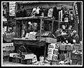
A street market on Belmont Avenue in 1962, when the neighborhood still had a large Jewish presence
See also
 In Spanish: Brownsville, Brooklyn para niños
