Travis County, Texas facts for kids
Quick facts for kids
Travis County
|
|||
|---|---|---|---|
|
County
|
|||
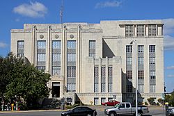
Heman Marion Sweatt Travis County Courthouse in Austin
|
|||
|
|||
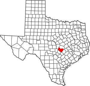
Location within the U.S. state of Texas
|
|||
 Texas's location within the U.S. |
|||
| Country | |||
| State | |||
| Founded | 1840 | ||
| Named for | William B. Travis | ||
| Seat | Austin | ||
| Largest city | Austin | ||
| Area | |||
| • Total | 1,023 sq mi (2,650 km2) | ||
| • Land | 990 sq mi (2,600 km2) | ||
| • Water | 33 sq mi (90 km2) 3.2% | ||
| Population
(2020)
|
|||
| • Total | 1,290,188 | ||
| • Estimate
(2023)
|
1,334,961 |
||
| • Density | 1,303.2/sq mi (503.2/km2) | ||
| Time zone | UTC−6 (Central) | ||
| • Summer (DST) | UTC−5 (CDT) | ||
| Congressional districts | 10th, 17th, 21st, 35th, 37th | ||
Travis County is a large county in Central Texas. It is home to Austin, which is the capital city of Texas. In 2020, about 1.29 million people lived here. This makes Travis County the fifth most populated county in Texas.
The county was created in 1840. It is named after William Barret Travis. He was a brave commander who fought at the Battle of the Alamo. Travis County is part of a bigger area called the Austin–Round Rock–Georgetown Metropolitan Statistical Area. It sits on the Balcones Fault. This is a natural line that separates the Edwards Plateau (hilly land) to the west from the Blackland Prairie (flat land) to the east.
Contents
History of Travis County
Ancient Times and Early European Visits
People have lived in the Travis County area for at least 11,000 years. Some of the oldest places where ancient tools have been found are the Levi Rock Shelter and Smith Rock Shelter. These are in the southwest and southeast parts of the county.
Before Europeans arrived, many Native American tribes lived here. They were often nomadic, meaning they moved around. They fished and hunted along the creeks. Barton Springs was a popular camping spot because it had fresh water. The Tonkawa tribe was common when the first settlers arrived. The Comanches and Lipan Apaches also visited the area.
In the 1600s, Spain claimed this region. But they did not try to settle it. In 1691, Domingo Terán de los Ríos likely traveled through the area. The first European settlers were Spanish friars (religious brothers). They arrived in 1730 and set up three temporary missions. These were near the Colorado River and Barton Springs. But they soon moved to the San Antonio River.
Mexican Rule and Texas Independence
In 1821, Mexico became independent from Spain. Mexico then encouraged people to move to Texas. They offered land and lower taxes. Many immigrants, mostly from the United States, moved here. An American land agent named Stephen F. Austin started a colony near what is now Bastrop, Texas in 1827. Early settlers like Josiah and Mathias Wilbarger came in the early 1830s.
In 1836, Texas declared its independence from Mexico. It formed the Republic of Texas. Vice President Mirabeau B. Lamar visited central Texas. He suggested moving the capital from Houston to a spot on the Colorado River. In 1839, this spot was chosen. It was first called Waterloo, then changed to Austin. It was named after Stephen F. Austin.
A new county was also created in 1840. Austin became its main city. This new county was named Travis County, after William B. Travis. The capital moved back to Houston for a short time. This happened during the Texas Archive War. But by 1845, Austin was again the capital. It became the capital of the new State of Texas when Texas joined the United States.
Civil War and Growth
In 1861, Travis County voted against leaving the Union. But most of Texas wanted to leave. So, Travis County became part of the Confederacy during the Civil War. After the Confederacy lost, Texas rejoined the Union in 1870.
Since the Civil War, Travis County has grown a lot. Its population has increased quickly. This growth is mostly because Austin and its nearby towns have grown. Today, Travis County is the fifth largest county in Texas by population. It is smaller than Harris (Houston), Dallas, Tarrant (Fort Worth), and Bexar (San Antonio) counties.
Geography of Travis County
Travis County covers about 1,023 square miles. Most of this is land, with about 33 square miles of water. It is in the southern part of central Texas. It lies between San Antonio and Dallas–Fort Worth.
The county is split by the Balcones Fault. This fault line separates two different types of land. To the west, you find the Texas Hill Country. This area has karst topography, meaning it has caves and springs. To the east, you see the flat, rich farmlands of the Blackland Prairie. The Colorado River flows through the county. It forms several man-made lakes, like Lake Travis, Lake Austin, and Lady Bird Lake.
Springs and Waterways
The western part of Travis County has many caves and springs. These have been important for people for thousands of years. Famous springs include Barton Springs, Deep Eddy, and Hamilton Pool.
Major Roads and Transportation
Several major highways cross Travis County. These include Interstate Highway 35, US Highways 183 and 290, and Texas Highway 71. IH-35 goes north to Waco and Dallas–Fort Worth. It goes south to San Antonio.
Other important roads include Texas Highway Loop 1, also called the "Mopac Expressway." It runs north to south through the county. Texas Highway 45 is part of a highway loop around Austin. Texas Highway 130 is an alternative route for long-distance drivers. It helps them avoid Austin and San Antonio.
Railroads
Amtrak's Austin station is in downtown Austin. You can catch the Texas Eagle train here. It travels daily between Chicago and San Antonio. It also goes to Los Angeles several times a week.
Travis County also has freight train service. It is served by the Union Pacific Railroad and the Austin Western Railroad.
Neighboring Counties
Travis County shares borders with these counties:
- Williamson County (north)
- Bastrop County (east)
- Caldwell County (southeast)
- Hays County (south)
- Blanco County (southwest)
- Burnet County (northwest)
Protected Natural Areas
Part of the Balcones Canyonlands National Wildlife Refuge is located in Travis County. This area helps protect wildlife.
People of Travis County
In 2010, there were over 1 million people living in Travis County. The population density was about 1,034 people per square mile.
The county is very diverse. In 2010, about 68% of people were White. About 9% were Black or African American. About 4.5% were Asian. And about 28% of the population was Hispanic or Latino.
Most people in Travis County speak English at home (about 71%). Spanish is spoken by about 22% of the population.
The median age in Travis County in 2000 was 30 years old. This means half the people were younger than 30, and half were older. About 23.8% of the population was under 18 years old.
Economy
In 2017, the average household income in Travis County was $68,350 per year. The average income per person was $38,820 per year. About 13.9% of the people lived below the poverty line.
The biggest employers in Travis County are government jobs. This includes the State of Texas, the U.S. Federal Government, Travis County, and the City of Austin. Public schools also employ many people. Other major jobs are in semiconductors (computer chips), software engineering, and healthcare.
Education
Schools for Kids
Travis County has many public school districts. The largest is Austin Independent School District, which serves most of Austin. Other districts include Eanes ISD, Lake Travis ISD, and Pflugerville ISD.
There are also state-run schools for special needs. These include the Texas School for the Blind and Visually Impaired and the Texas School for the Deaf.
Colleges and Universities
The biggest university in Travis County is the University of Texas at Austin. Other universities include St. Edward's University, Huston–Tillotson University, and Concordia University Texas.
For community college, most of the county is served by Austin Community College District (ACC).
Healthcare
Central Health is a special district that helps provide healthcare. It was started in 2004. Brackenridge Hospital was an important hospital for many years. In 2017, it was replaced by the Dell Seton Medical Center.
Communities in Travis County
Cities (in multiple counties)
- Austin (county seat)
- Cedar Park
- Elgin
- Leander
- Mustang Ridge
- Pflugerville
- Round Rock
Cities (only in Travis County)
Villages
Census-Designated Places
These are areas that are like towns but are not officially incorporated as cities.
- Barton Creek
- Garfield
- Hornsby Bend
- Hudson Bend
- Lost Creek
- Manchaca
- Shady Hollow
- Steiner Ranch
- Wells Branch
Unincorporated Communities
These are smaller communities that are not part of any city or village.
- Bluff Springs
- Carl
- Carlson
- Cedar Valley
- Cele
- Colton
- Del Valle
- Dessau
- Dunlap
- Elroy
- Littig
- Lund
- Marshall Ford
- McNeil
- Moore's Crossing
- New Sweden
- Pilot Knob
- Round Mountain
- Spicewood
- Three Points
- Turnersville
Austin Neighborhoods
- Anderson Mill
- Four Points
- Jollyville
- Kincheonville
- Merrilltown
- Oak Hill
- Onion Creek
- Pleasant Hill
- Tanglewood Forest
- Windemere
- Waters Park
See also
 In Spanish: Condado de Travis para niños


