Berkshire County, Massachusetts facts for kids
Quick facts for kids
Berkshire County
|
|||
|---|---|---|---|
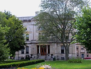
Berkshire County Courthouse
|
|||
|
|||
| Motto(s):
Firmus et Paratus
(Latin "Steadfast and Ready") |
|||
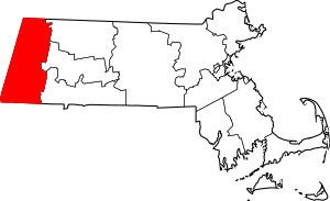
Location within the U.S. state of Massachusetts
|
|||
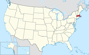 Massachusetts's location within the U.S. |
|||
| Country | |||
| State | |||
| Founded | April 24, 1761 | ||
| Named for | Berkshire, England | ||
| Seat | Pittsfield | ||
| Largest city | Pittsfield | ||
| Area | |||
| • Total | 946 sq mi (2,450 km2) | ||
| • Land | 927 sq mi (2,400 km2) | ||
| • Water | 20 sq mi (50 km2) 2.1%% | ||
| Population
(2020)
|
|||
| • Total | 129,026 | ||
| • Estimate
(2023)
|
126,818 |
||
| • Density | 136.39/sq mi (52.661/km2) | ||
| Demonym(s) | Berkshirite | ||
| Time zone | UTC−5 (Eastern) | ||
| • Summer (DST) | UTC−4 (EDT) | ||
| Congressional district | 1st | ||
Berkshire County is located in the western part of the U.S. state of Massachusetts. In 2020, about 129,026 people lived here. Its biggest city and main town is Pittsfield.
The county was started in 1761. The famous Berkshire Hills are right in the middle of Berkshire County. People who live here are called Berkshirites. Today, Berkshire County is mostly a historical area. It doesn't have a full county government anymore, except for a few offices like the sheriff's.
Contents
Exploring Berkshire County's Geography
Berkshire County covers about 946 square miles. Most of this area, 927 square miles, is land. The rest is water, like lakes and rivers. It is the second-largest county in Massachusetts by land size.
The highest natural point in Massachusetts, Mount Greylock, is in Berkshire County. It stands at 3,492 feet (1,064 meters) tall.
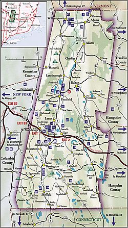
Berkshire County is special because it touches three other states: Vermont, New York, and Connecticut. Only one other county in Massachusetts does this. It also touches both the northern and southern borders of Massachusetts.
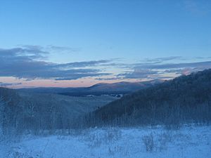
The Berkshire Hills and the Taconic Mountains run through the county from north to south. These mountains are high up, which makes them cooler in summer. Many tourists and summer visitors come here to escape the heat of lower areas.
Neighboring Counties Around Berkshire
Berkshire County shares borders with several other counties:
- Bennington County, Vermont (to the north)
- Franklin County (to the northeast)
- Hampshire County (to the east)
- Hampden County (to the southeast)
- Litchfield County, Connecticut (to the south)
- Dutchess County, New York (to the southwest)
- Columbia County, New York (to the west)
- Rensselaer County, New York (to the northwest)
People and Population in Berkshire County
| Historical population | |||
|---|---|---|---|
| Census | Pop. | %± | |
| 1790 | 30,263 | — | |
| 1800 | 33,885 | 12.0% | |
| 1810 | 35,907 | 6.0% | |
| 1820 | 35,720 | −0.5% | |
| 1830 | 37,835 | 5.9% | |
| 1840 | 41,745 | 10.3% | |
| 1850 | 49,591 | 18.8% | |
| 1860 | 55,120 | 11.1% | |
| 1870 | 64,827 | 17.6% | |
| 1880 | 69,032 | 6.5% | |
| 1890 | 81,108 | 17.5% | |
| 1900 | 95,667 | 18.0% | |
| 1910 | 105,259 | 10.0% | |
| 1920 | 113,033 | 7.4% | |
| 1930 | 120,700 | 6.8% | |
| 1940 | 122,273 | 1.3% | |
| 1950 | 132,966 | 8.7% | |
| 1960 | 142,135 | 6.9% | |
| 1970 | 149,402 | 5.1% | |
| 1980 | 145,110 | −2.9% | |
| 1990 | 139,352 | −4.0% | |
| 2000 | 134,953 | −3.2% | |
| 2010 | 131,219 | −2.8% | |
| 2020 | 129,026 | −1.7% | |
| 2023 (est.) | 126,818 | −3.4% | |
| U.S. Decennial Census 1790–1960 1900–1990 1990–2000 2010–2018 |
|||
In 2010, there were 131,219 people living in Berkshire County. Most people, about 92.5%, were white. Other groups included Black or African American (2.7%), Asian (1.2%), and American Indian (0.2%). About 3.5% of the population was of Hispanic or Latino origin.
Many families in Berkshire County have roots in different countries. The largest groups include people of Irish, Italian, French, English, and German backgrounds.
The average age of people in the county was 44.7 years. About 25.9% of households had children under 18 living with them.
A Look at Berkshire County's History
The Mahican Native American tribe lived in this area for a long time. English settlers started arriving in the early 1700s. In 1724, the English bought land in what is now southern Berkshire County from the Native Americans. Berkshire County was officially created in 1761. Before that, it was part of Hampshire County.
In the 1800s, rich American families loved Berkshire County. They built large, fancy homes called "cottages" in the countryside. This time was known as the Gilded Age. Later, in the 1900s, this era ended. Many of these grand homes were torn down or burned. Others became schools, historical sites, or inns.
Today, Berkshire County is famous as a summer destination. It is home to the Boston Symphony Orchestra at Tanglewood. You can also visit cool places like the Clark Art Institute, the Norman Rockwell Museum, and Mass MOCA.
Communities in Berkshire County
Cities in Berkshire County
- North Adams
- Pittsfield (This is the main county seat)
Towns in Berkshire County
Census-Designated Places
These are specific areas within towns that the U.S. Census Bureau identifies for statistics.
Getting Around Berkshire County
You can travel around the county using the Berkshire Regional Transit Authority bus service. For longer trips, Amtrak trains and Peter Pan buses are available at the Pittsfield station.
Airports in the County
- Harriman-and-West Airport
- Pittsfield Municipal Airport (Massachusetts)
- Walter J. Koladza Airport
Main Roads and Highways
Many important roads pass through Berkshire County, connecting it to other parts of Massachusetts and neighboring states. These include:
 I‑90
I‑90 US 7
US 7 US 20
US 20 Route 2
 Route 7A
 Route 8
 Route 8A
 Route 9
 Route 23
 Route 41
 Route 43
 Route 57
 Route 71
 Route 102
 Route 116
 Route 143
 Route 183
 Route 295
Famous People from Berkshire County
Many well-known people have lived or spent time in Berkshire County:
- Scholar and civil rights activist W.E.B. Du Bois was born in Great Barrington. You can visit sites related to his life on the African American Heritage Trail.
- Folk singer Arlo Guthrie lives in Berkshire County.
- Author Nathaniel Hawthorne lived in Lenox. He wrote famous books like The House of the Seven Gables there.
- Author Herman Melville lived in Pittsfield at a home called Arrowhead. He wrote his famous novel Moby-Dick there.
- Artist Norman Rockwell lived in Stockbridge.
- Singer-songwriter and guitarist James Taylor lives in Berkshire County.
- Author Edith Wharton had a home in Lenox.
- Actor Mark Wahlberg often visits and has a home in Pittsfield.
- Actress Elizabeth Banks is from Pittsfield and often visits.
- Actress Karen Allen lives in Monterey.
- Cellist Yo-Yo Ma has a home in Tyringham.
Economy of Berkshire County
Berkshire County is the top producer of milk in Massachusetts.
See also
 In Spanish: Condado de Berkshire para niños


