Chain Home Low facts for kids

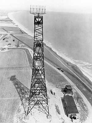
Chain Home Low station at Hopton-on-Sea
|
|
| Country of origin | United Kingdom |
|---|---|
| Introduced | July 1939 |
| No. built | 100+ |
| Frequency | 200 MHz |
| PRF | 400 Hz |
| Beamwidth | 1.5° (horizontal) |
| Pulsewidth | 3 µs |
| RPM | Up to 3.3 |
| Power | 150 kW |
| Other Names | AMES Type 2, CD Mark I |
Chain Home Low (CHL) was a special early warning radar system used by the RAF in the United Kingdom during World War II. Its main job was to find enemy aircraft flying very close to the ground or sea. The name "Chain Home Low" came from its ability to detect planes flying below the reach of the original Chain Home (CH) radars.
Most CHL radars were placed right next to the bigger Chain Home stations. This allowed them to cover areas the older radars couldn't. CHL could reliably spot aircraft flying as low as 500 feet (about 150 meters). Its official name was AMES Type 2, but hardly anyone used that name.
The British Army first developed this system to find enemy ships in the English Channel. It used new electronic parts that were also being made for Airborne Interception radars. These parts worked on a higher frequency (200 MHz), which meant CHL could use smaller antennas. These antennas could be turned to scan for targets, unlike the huge, fixed antennas of the older Chain Home system.
When the war started, German planes often flew very low to drop mines. The original Chain Home radars couldn't see targets below 1.5 degrees above the horizon. This meant low-flying planes only appeared when they were very close. To fix this, Robert Watson Watt quickly set up many of these new CHL systems along the coast. CHL remained a vital part of Britain's radar network throughout the war. It was later replaced by newer systems like the AMES Type 80.
Contents
How CHL Radar Was Developed
An Accidental Discovery
The story of CHL began with early tests of Airborne Interception radars in 1936. These radars were designed to help night fighter pilots find enemy planes in the dark. A team at Bawdsey Manor, led by "Taffy" Bowen, was working on these new radars. They needed the radar to use very short radio waves so the antennas would be small enough for an airplane. They decided on a system that used 1.5-meter waves, which is about 193 MHz.
During early tests, the team found it hard to detect other aircraft. This was mainly because of strong reflections from the ground. These ground reflections created a powerful signal that blocked out everything beyond the plane's own altitude. This meant a German bomber flying at 15,000 feet (about 4,500 meters) would only become visible at that same distance, which was too close.
However, these tests also showed something unexpected. As their test plane flew over Bawdsey, which is on the coast, the team saw strong, steady signals. They soon realized these signals were coming from cranes at the Harwich docks, miles away. Other smaller signals were identified as boats in the Channel. The radar was detecting these ships much farther away than it could detect planes, even though it wasn't designed for that.
Robert Watson-Watt quickly saw the potential of this discovery. He asked the team to test it properly. In September 1937, a series of military exercises in the Channel provided the perfect chance. Their test plane successfully detected several Royal Navy ships. This showed that radar could be used to spot ships, even in bad weather.
The Army's Coast Defence Radar (CD)
The British Army was actually the first to think about using radar. In 1931, two scientists, W. A. S. Butement and P. E. Pollard, suggested using radio pulses to measure distances to ships. The Army wasn't interested until they heard about Watson-Watt's work. Then, they became very keen. In 1936, a special "Army Cell" team was set up at Bawdsey.
Butement and Pollard, the only available experts, began two projects. One was a mobile version of Chain Home. The other was Gun Laying radar (GL), a smaller unit to help aim anti-aircraft artillery at planes. Both used longer radio waves, making their antennas quite large.
After the amazing ship-detection tests, Butement started looking for ways to use Bowen's 1.5-meter radar for new purposes. They decided to develop Coast Defence radar (CD). This system would help the Army's coastal artillery aim their big guns at ships, even at night or in fog. The CD radar was like the GL system but used the shorter 1.5-meter waves. This allowed it to have a much more accurate antenna, which was important for aiming guns.
In July 1939, something interesting was noticed during tests. When the Army's big 9.2-inch guns missed their targets, the splash of water caused by the shell would show up clearly on the radar screen. This meant gunners could correct their aim by watching where their shells landed on the radar, just like they would with human observers.
CD Becomes CHL

In 1938, RAF pilots found a way to avoid detection by Chain Home: flying at very low altitudes. The CH radar could only see targets above 1.5 degrees from the horizon. This meant planes flying low were invisible until they were just a few miles away. They could even fly between two CH stations without being seen at all. At first, this wasn't a big worry, as bombers usually flew high.
But as the problem became clearer, Watson-Watt grew concerned. In July 1939, he ordered twenty-four CD radar sets. He called them AMES Type 2. His plan was to put one at each Chain Home station to cover low-flying targets, down to 500 feet (150 meters). These CHL sets were different from the Army's CD versions mainly in their antenna. They had four stacked antennas, which helped estimate a target's height.
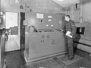
CHL was introduced very quickly. It was a simple system where an operator had to manually swing the antenna to find targets. At first, the antennas were even powered by WAAFs using bicycle-like machines connected to gears!
Soon after the war began, German pilots accidentally discovered the same low-flying trick. Planes sent on mine-laying missions, which flew very low over water, often returned safely. Other planes flying higher were usually caught. It became clear that flying low made them invisible to radar.
The German air force, the Luftwaffe, soon started low-level attacks that were very hard to stop. More CHL sets were ordered and placed to fill gaps between the existing stations. In April 1941, all CHL sets were upgraded with new, motorized antennas that could spin around.
CHL and GCI Radars
When CHL was first used, it helped detect low-flying targets and track individual planes over land. Unlike Chain Home, which always faced the sea, CHL could turn in any direction. However, this tracking role became less important when the AMES Type 7 radar arrived in 1942. The Type 7 was a more powerful version of CHL with a larger antenna.
The Type 7 antenna spun continuously in a full circle. It showed targets on a map-like screen called a plan-position indicator (PPI). CHL operators had to calculate a target's position from its range and direction. But Type 7 operators could see all planes in their area at once, making it much easier to track them. So, CHL was used more for early warnings, telling Type 7 stations where to look for targets. Later, even lower-flying planes (down to 50 feet or 15 meters) could be detected by Chain Home Extra Low (CHEL) radars, which were often placed with CHL sites.
Some CHL systems were made mobile during the war. These units were put on trucks, allowing them to move quickly. This gave the RAF more ways to find and fight enemy planes.
AMES Type 11
Even as newer radars like GCI (Ground Controlled Interception) came along, CHL remained important for early warnings. In February 1942, the Germans moved two of their battleships right through the English Channel. This was a big embarrassment for Britain. It happened partly because the Germans used very effective jamming, which made the CH and CHL radars along the coast useless without operators even realizing it.
To fix this, the RAF started developing the AMES Type 11. This was a truck-mounted CHL system that used a different radio frequency (500–600 MHz). This frequency was chosen because it matched German anti-aircraft radars. The idea was that German jamming might also affect their own radars. Type 11 radars were only used when jamming was expected, to avoid giving the Germans clues about them. In the end, they were not used very often.
List of Chain Home Low Sites
- Anstruther, Fife
- Ballymartin, County Down, Northern Ireland
- Bamburgh, Northumberland
- Bard Hill, Holt, Norfolk
- Bawdsey, Suffolk
- Beachy Head, Sussex
- Beer Head, Devon
- Bembridge, Isle of Wight
- Bempton, Yorkshire
- Ben Hough, Tiree
- Bexhill, Sussex
- Blackhead, County Antrim, Northern Ireland
- Bolt Tail, Devon
- Boniface Down, Isle of Wight
- Carsaig, Isle of Mull
- Cleadon, County Durham
- Clett, Shetland Islands
- Cockburnspath, Borders
- Cocklaw, Peterhead, Aberdeenshire
- Covehithe, Suffolk (CHEL site)
- Crannoch Hill, Banff, Banffshire
- Craster, Northumberland
- Cregneash, Isle of Man
- Cresswell, Northumberland
- Cromarty, Ross and Cromarty
- Crustan, Orkney Islands
- Deerness, Orkney Islands
- Doonies Hill, Gregness, Aberdeen
- Dover
- Downhill, County Londonderry, Northern Ireland
- Dunderhole Point, near Tintagel, Cornwall
- Dunnet Head, near Thurso, Caithness
- Dunwich, Suffolk
- Easington, Yorkshire
- East Cliff, Portland, Dorset
- Eorodale, Isle of Lewis
- Fair Isle
- Fairlight, Sussex
- Foreness Point, Kent
- Formby, Lancashire
- Glenarm, County Antrim, Northern Ireland
- Goldsborough, Whitby, Yorkshire
- Great Orme, Llandudno, North Wales
- Greian Head, Isle of Barra
- Grutness, Sumburgh, Shetland Islands
- Happisburgh, Norfolk
- Hartland Point, Devon
- Hawcoat, Barrow in Furness, Lancashire
- Highdown Hill, Angmering, Sussex
- Hopton, Norfolk
- Humberston, Lincolnshire
- Hythe, Kent
- Islivig, Isle of Lewis
- Jacka, Portloe, Cornwall
- Kendrom, Kilmaluag, Isle of Skye
- Kessingland (Pakefield) Lowestoft, Suffolk
- Kete, Dale, Pembrokeshire
- Kilchiaran, Isle of Islay
- Kingswear, Devon
- Kinley Hill, Seaham, County Durham
- The Law, Carnoustie, Angus
- Margam, Margam Country Park, Neath Port Talbot
- Mark's Castle, Land's End, Cornwall
- Minehead, Minehead, Somerset
- Mossy Bottom, Shoreham, West Sussex
- Navidale, Helmsdale, Sutherland
- Needles, Isle of Wight
- North Foreland, Kent
- Oxwich, Swansea
- The Pen, Pembrey, Carmarthenshire
- Pen Olver, Lizard, Cornwall
- Pen y Bryn, Caernarfonshire
- Point of Stoer, Sutherland
- Poling, West Sussex
- Prestatyn, Denbighshire
- Rame Head, Cornwall
- Ramsgate, Kent
- Ravenscar, North Yorkshire
- Roddans Port, County Down, Northern Ireland
- Rodel Park, Rodel, Harris, Western Isles
- Rosehearty, Aberdeenshire
- St Bees Head, Cumberland
- St Cyrus, Aberdeenshire
- St Davids Head, Pembrokeshire
- St Twynells, Pembrokeshire
- Sango, Durness, Sutherland
- Saxa Vord, Unst, Shetland
- Shotton, County Durham
- Skaw, Unst
- Skendleby, Lincolnshire
- South Ronaldsay, Orkney
- South Stack, Anglesey
- Spittal, Northumberland
- Strumble head, Pembrokeshire
- Swansea Bay, Glamorgan
- Thorpeness, Suffolk
- Trevose Head, Cornwall
- Truleigh Hill, Bramber, West Sussex
- Ulbster, Wick, Caithness
- Ventnor, Isle of Wight
- Walton on Naze, Essex
- Warden Point,Isle of Sheppey, Kent
- Watsness, Walls, Shetland
- Westburn, Aberdeen
- Westcliff, Portland, Dorset
- Whitehawk, Brighton, East Sussex
- Whitstable, Kent
- Worth Matravers, Swanage, Dorset
- St. Roches Hill (The Trundle) West Sussex.
See also
- Chain Home
- Air Ministry Experimental Station
- ROTOR
- Linesman/Mediator
 | Bayard Rustin |
 | Jeannette Carter |
 | Jeremiah A. Brown |


