Geography of Massachusetts facts for kids
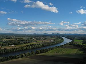
Massachusetts is a state in the United States. It's the 7th smallest state by land area, covering about 10,555 square miles (27,336 km²). To the north, it shares borders with New Hampshire and Vermont. To the west is New York, and to the south are Connecticut and Rhode Island. The Atlantic Ocean and Gulf of Maine are to its east. Massachusetts is the most populated state in New England.
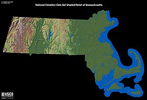
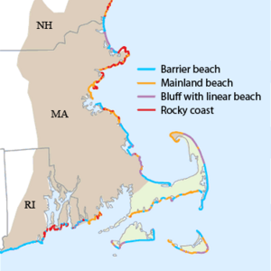
People often call Massachusetts "The Bay State." This is because of its many large bays that shape its coast. These include Massachusetts Bay and Cape Cod Bay in the east, and Buzzards Bay in the south. Some towns near the Rhode Island border are also next to Mount Hope Bay. In the southeastern part of the state, there's a large, sandy, arm-shaped piece of land called Cape Cod. This forms the southern edge of the Gulf of Maine. South of Cape Cod, across Nantucket Sound, are the islands of Martha's Vineyard and Nantucket.
Central Massachusetts has rolling, rocky hills. Western Massachusetts has a rich valley and mountains around the Connecticut River, plus the Berkshire Mountains.
Boston is the biggest city in Massachusetts. It sits at the very end of Massachusetts Bay, where the Charles River meets the ocean. Most people in Massachusetts live in the Boston area, which covers much of eastern Massachusetts. This eastern part is quite crowded and mostly made up of suburbs. Western Massachusetts has the Connecticut River Valley, which is a mix of cities like Springfield and Northampton, and rural college towns like Amherst. It also has the Berkshire Mountains, which are part of the Appalachian Mountains and are mostly rural.
Massachusetts has 351 cities and towns. Every part of the state is within an official city or town, even if some towns have large rural areas. The state's 14 counties mostly serve as judicial districts and don't have many government duties.
Contents
Exploring Massachusetts' Landscape
Massachusetts has a varied landscape, from mountains in the west to sandy beaches in the east. The entire state was once covered by a huge ice sheet during the Wisconsin glaciation (Ice Age). This ice shaped the land we see today. You can still find many features left by the glaciers, like kettle ponds, drumlins (oval hills), and moraines (piles of rock and dirt). The soil is often rocky and not very fertile, except for some rich floodplains.
Mountains and Valleys
The western part of Massachusetts has the highest elevations. The Taconic Mountains, which are part of the Appalachian system, run along the border with New York. Here, you'll find Mount Everett at 2,624 feet (800 meters) and the state's highest point, Mount Greylock, at 3,491 feet (1,064 meters).
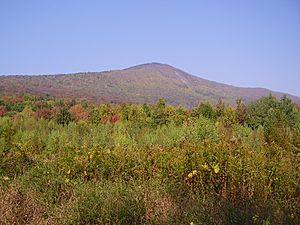
Between the Taconic Mountains and the rest of the state is the Housatonic-Hoosic valley. East of this valley are the The Berkshires, a wide area of rolling hills that are an extension of Vermont's Green Mountains.
East of the Berkshires is the Connecticut River Valley, also known as the Pioneer Valley. This valley formed millions of years ago when continents pulled apart. You can even find Dinosaur footprints near Mount Tom from that time! Glaciers later left behind very rich soil here.
Further east, hills rise steeply, forming a divide between the Connecticut River basin and other rivers. Mount Wachusett, at 2,006 feet (611 meters), is the highest point east of the Connecticut River. Closer to the coast, the hills get lower, and the land becomes more gently rolling. The Blue Hills, just south of Boston, stand out from the surrounding area. Massachusetts might even be named after the Massachusett people's name for their highest point, Great Blue Hill, which is 635 feet (194 meters tall).
Coastal Features
The Massachusetts coastline has many deep bays, coves, and river mouths. These are separated by narrow pieces of land. Some of these natural harbors led to the growth of historic ports like Newburyport, Gloucester, Salem, Boston, and New Bedford.
The state also has a few small barrier islands, with Plum Island being the largest. The biggest piece of land sticking out into the ocean is the Cape Cod peninsula. Its shape comes from glacial deposits, and its famous sandy beaches were formed by ocean currents moving sand. South of Cape Cod, other glacial deposits form the state's largest islands: Martha's Vineyard, Nantucket, the Elizabeth Islands, and Monomoy Island.
Massachusetts' Climate
Massachusetts has a humid continental climate. This means summers are warm, and winters are quite cold. In January, temperatures are usually below freezing across most of the state.
The central and western parts of Massachusetts, like Worcester and the Berkshires, have colder winters than the coastal areas or the Connecticut River Valley. For example, Stockbridge in the Berkshires has an average January temperature of 21.6°F (-5.8°C). Boston, on the coast, averages 29.0°F (-1.7°C) in January. Martha's Vineyard, an island, has the warmest average winter temperature at 31.8°F (-0.1°C) because the ocean keeps it warmer.
Summer temperatures are highest in cities due to the "heat island effect." Boston averages 81.7°F (27.6°C) in July, Worcester 79.2°F (26.2°C), and Springfield 85.0°F (29.4°C). The coolest summer temperatures are in the Berkshires and on the islands. Nantucket Island's warmest month, August, averages 68.7°F (20.4°C).
Rain and snow are spread fairly evenly throughout the year. Boston gets about 43 inches (1,092 mm) of precipitation annually. Springfield gets about 45.8 inches (1,163 mm). Interior Massachusetts tends to get more summer rain from thunderstorms, while coastal areas get less.
All parts of Massachusetts get a good amount of snow in winter. However, coastal areas and the Connecticut River Valley usually get about two-thirds the amount of snow as central Massachusetts and the Berkshires. Boston averages 43.3 inches (110 cm) of snow, while Worcester averages 69.1 inches (176 cm). Snow often covers the ground for weeks in January and February.
Massachusetts is quite sunny compared to other places at the same latitude. Boston gets at least 50% of possible sunshine every month. In summer and early autumn, it's often over 60% sunny. The hottest temperature ever recorded in Massachusetts was 108°F (42.8°C).
Wildlife and Nature
Most of Massachusetts is covered in forests, especially the inland areas. Even in the suburbs of eastern Massachusetts, you'll see many trees around houses. If you look out from a high hill, you'll see a sea of treetops, with only a few buildings peeking out.
About 46% of Massachusetts is forest land. Another 7% is rural parkland, which is also mostly forest. While cities and suburbs take up 36% of the state, even these areas outside the main city centers often have houses surrounded by woods. Only about 4% of the state is used for crops, and less than 1% for pastures. About 2% of the state is wetlands like marshes and swamps.
The natural environment of Massachusetts has three main types of ecosystems. On Cape Cod and the islands, you'll find Atlantic coastal pine barrens. These are forests with pine trees that grow on sandy soil and can sometimes catch fire naturally. Most of the rest of the state, including eastern and south-central Massachusetts and the Connecticut River Valley, has Northeastern coastal forests. These are a mix of hardwood trees like oak, maple, and hickory, and evergreen trees like pine. In the Berkshires and north-central Massachusetts, you'll find New England-Acadian forests. These have more spruce and hemlock trees, with some birch. Over time, many old farms have turned back into woodlands.
Animals in Massachusetts
The forests and wooded suburbs are home to many different animals. There are lots of white-tailed deer. Sometimes there are concerns about too many deer because their natural predators, like wolves, were hunted to extinction in Massachusetts. However, coyotes have been moving into the state and are now helping to control the deer population.
You can also find raccoons, wild turkeys, and eastern gray squirrels throughout Massachusetts. In the more rural western parts of the state, larger mammals like moose and black bears have returned. This is largely because forests have grown back after farms were abandoned.
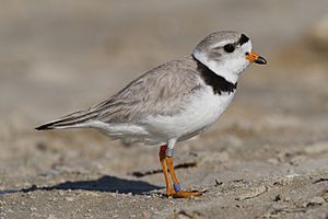
Massachusetts is on the Atlantic Flyway, which is a big route for birds that migrate along the Atlantic coast. Lakes in central Massachusetts are home to the common loon. Many long-tailed ducks spend the winter off Nantucket. Small islands and beaches are important breeding spots for birds like roseate terns and the threatened piping plover. Places like the Monomoy National Wildlife Refuge are crucial for shorebirds and marine animals, including a large group of gray seals.
Freshwater fish in Massachusetts include bass, carp, catfish, and trout. In the ocean, you can find fish like Atlantic cod and haddock, and American lobsters. Other marine animals include harbor seals and different types of whales, such as the endangered North Atlantic right whales, humpback whales, fin whales, and minke whales. You might also spot Atlantic white-sided dolphins.
Rivers and Waterways
Massachusetts has many important rivers and waterways. Here are some of the major ones:
- Hudson River (mostly in New York State)
- Housatonic River
- Connecticut River (New England's longest river!)
- Thames River (Connecticut)
- Blackstone River
- Charles River
- Merrimack River
Smaller streams and underground water flows drain the coastal areas and islands into the Atlantic Ocean and Narragansett Bay.
Where People Live
The Northeast megalopolis, a large urban area, extends into Massachusetts. It covers most of eastern Massachusetts, starting around Worcester. It also includes the cities of Springfield, Holyoke, and Northampton, which connect to the urban areas of Hartford and New Haven in Connecticut.
Most people in Massachusetts live in cities and towns that are close together. For example, in the Boston area, the City of Boston and its nearby suburbs make up more than half of the population. Older cities like Lawrence, Lowell, and Brockton are also densely populated.
However, the fastest population growth is happening in the outer parts of the state's urban areas, where new homes are being built. Even though the state's population isn't growing much overall, towns along Interstate 495, which is near the western edge of the Boston area, are seeing steady growth.
Some parts of the state, especially in the Berkshires and the hills west of Worcester, are very rural with few people living there.
Jobs and Economy
Massachusetts has a strong economy, with about 3.2 million jobs in 2005. Most of these jobs are in the service sector, meaning they provide services rather than making physical goods.
The biggest job center is the Boston-Cambridge-Quincy area, also known as Greater Boston. This area has about half of all the jobs in Massachusetts. It's especially strong in "knowledge-intensive" jobs. This includes:
- Information Technology: Many jobs in software and technology.
- Finance: A large number of jobs in banking and investments.
- Professional Services: Jobs in management and technical consulting.
- Education: Greater Boston is famous for its many top universities, like Harvard University and MIT, which employ many people.
These knowledge-based jobs make up a much larger part of Boston's economy than they do for the rest of Massachusetts or the United States.
Other important job centers in Massachusetts include Springfield and Worcester. These areas also have many service jobs, but they have a higher percentage of manufacturing jobs compared to central Boston. Many of these manufacturing jobs are in making computers and electronic products.
In the southeastern part of the state, especially on Cape Cod, tourism is very important. This area has a lot of jobs in retail (stores) and leisure and hospitality (hotels, restaurants).
In the far western part of the state, the Pittsfield area also relies on tourism, especially in the Berkshires. It also has a high percentage of jobs in education and healthcare.
See also
 In Spanish: Geografía de Massachusetts para niños
 | Sharif Bey |
 | Hale Woodruff |
 | Richmond Barthé |
 | Purvis Young |


