
History of Toronto facts for kids

Toronto is a big city in Canada with a long and interesting past. For over 12,000 years, Indigenous people have lived in the Toronto area. The Huron-Wendat were among the first known groups to build farming villages here about 1,600 years ago.
In the 1600s, the Toronto Carrying-Place Trail along the Humber River became a key spot for controlling the fur trade. The Seneca people even had a village called Teiaiagon with about 2,000 people along this trail. Later, the French set up trading posts, like Fort Rouillé in 1751. They left these posts when the British took over French North America during the Seven Years' War.
The British started settling Toronto in the 1790s, building a fort called Fort York at the entrance to Toronto Harbour. During the War of 1812, American forces attacked the village and fort. After the war, there was tension between the colony's leaders and those who wanted more democracy. This led to the Rebellions of 1837-1838.
In the second half of the 1800s, Toronto grew into an important city. It was connected to the rest of Ontario by railways and to American and British markets by its port. By 1914, Toronto's financial businesses were competing with Montreal. Many American companies also chose Toronto for their branch offices.
World War I and World War II greatly affected the city. Thousands of people volunteered to fight, and those at home helped with the "total war" effort. After World War II, many new immigrants came to the region. In 1954, the Province of Ontario created a regional government called Metropolitan Toronto, which included Toronto and its surrounding areas. This government invested a lot in roads and public transport, leading to a big increase in population and industry.
In the late 1900s, Toronto became Canada's largest city, surpassing Montreal. It also became a major economic hub and one of the most multicultural cities in the world. In 1998, the Province of Ontario combined Toronto and its suburbs into one large city.
Contents
What Does "Toronto" Mean?
Toronto was first used on maps in the late 1600s and early 1700s. It referred to Lake Simcoe and the path used to carry boats to it. Eventually, the name moved south to the mouth of the Humber River, where Toronto is today. This area was the end of the Toronto Carrying-Place Trail, a route from Lake Simcoe and Georgian Bay.
The word probably comes from the Mohawk word tkaronto. This means "where there are trees standing in the water." It first described a place near present-day Orillia where people had put stakes in the water for fishing. French maps from the 1680s to 1760s called Lake Simcoe "Lac de Taronto." The spelling changed to Toronto in the 1700s. As the portage route became more used, the name spread and was eventually given to a French trading fort near Lake Ontario.
The name's origin might also be confusing because many First Nations groups lived in the area. These included the Neutral, Seneca, Mohawk, Cayuga, and Wendat nations. Some think the name comes from the Seneca word Giyando, meaning "on the other side." This referred to where the Humber River narrows near the village of Teiaiagon.
From August 1793 to March 1834, the settlement was called York. It was named after Prince Frederick, Duke of York and Albany. To avoid confusion with York in England and New York, it was sometimes called "Little York." In 1804, a settler asked to change the name back to Toronto, but this was rejected. The town finally changed its name back to Toronto when it became a city.
Early History of Toronto
First People in the Area (9,000 BCE to 1000 BCE)

Toronto was covered by ice during the Last Glacial Period. The ice started to melt away around 13,000 BCE. After the ice age, Toronto's shoreline changed as glacial Lake Iroquois grew and shrank. The first people arrived in the area between 9000 BCE and 8,500 BCE. These early settlers traveled in small family groups, hunting animals like caribou, mammoths, and mastodons. Many of their old campsites are now under Lake Ontario.
As the climate got warmer around 6,000 BCE, Toronto's environment changed from very cold to a milder, temperate climate. The shoreline also changed a lot. Erosion from the Scarborough Bluffs created a sandbar that later became the Toronto Islands.
Villages and Trade Routes (1000 BCE to 1200 CE)

First Nations people set up fishing camps along Toronto's rivers as early as 1,000 BCE. By 500 CE, up to 500 people lived along each of Toronto's three main rivers: the Don, Humber, and Rouge River. These communities created trails and water routes in the Toronto area. One important trail, the "Toronto Passage," followed the Humber River north. It was a key shortcut between Lake Ontario and the upper Great Lakes.
New crops like corn, sunflowers, and tobacco arrived from the south around 600 CE. These new crops changed how people lived. They started forming semi-permanent villages to farm. People would leave these villages at certain times of the year to hunt, fish, and gather food. The earliest known Iroquoian farming village dates back to about 900 CE. These villages were built on high, protected land, close to water for hunting, fishing, trade, and defense. They usually stayed in one spot for 10 to 20 years before moving to a new site.
Later Indigenous Settlements (1200–1700)

Several Iroquoian villages from the 1200s have been found in Toronto. From the 1300s to the 1500s, the Iroquoian people in the area moved north. They joined the growing Huron-Wendat Confederacy. During this time, the Huron-Wendat used Toronto for hunting, and the Toronto Passage remained an important route.
Even though Europeans didn't visit Southern Ontario in the 1500s, European goods started to arrive. In the 1600s, almost half of Southern Ontario's First Nations population died from diseases brought by Europeans. This, along with the desire for furs, led to the Beaver Wars. The Haudenosaunee Confederacy from the south attacked the Huron-Wendat. The Haudenosaunee defeated the Huron-Wendat in the mid-1600s.
After the Haudenosaunee took control, they built several settlements on the north shore of Lake Ontario. The Seneca people, one of the Haudenosaunee nations, built two villages in what is now Toronto: Teiaiagon near the Humber River and Ganatsekwyagon near the Rouge River. These villages helped the Haudenosaunee control the north-south passage in Toronto. Christian missionaries visited these villages in the 1660s and 1670s. Both Seneca settlements were abandoned by 1687. After the Haudenosaunee left, the Mississaugas moved into the area in the late 1600s.
Early European Visits (1600s–1793)
French Explorers and Traders

The first European to reach Lake Ontario near Toronto might have been French explorer Étienne Brûlé in 1615. He may have used the Toronto Passage. By the 1660s, Europeans were active in the Toronto area, with missionaries visiting First Nations settlements.
By the 1700s, Toronto became important for French fur traders because of its location on the Toronto Passage. In 1720, Captain Alexandre Dagneau built Fort Douville on the Humber River. This trading post was meant to attract First Nations traders away from British posts. Its success led the British to build a larger trading post in Oswego. The French abandoned Fort Douville after Fort Oswego was completed in 1726.

The French built another trading post in 1750 on the Humber River. It was so successful that they built Fort Rouillé in 1751, where Exhibition Place is today. After the British captured Fort Niagara in 1759, the French destroyed Fort Rouillé and left for Montreal. In 1760, British forces secured the Toronto area. The Treaty of Paris of 1763 officially ended the Seven Years' War, giving New France to the British. This included the Toronto area.
Loyalist Settlers Arrive
Before 1775, there were only a few European families in the western part of the colony of Quebec. But after the American Revolutionary War, many settlers known as United Empire Loyalists arrived. These were American colonists who wanted to stay loyal to the British Crown or felt unwelcome in the new United States. Many Loyalists moved from the United States to the unsettled lands north of Lake Erie and Lake Ontario. Some had fought for the British and were given land here.
In 1786, Lord Dorchester, the Governor-in-Chief of British North America, arrived. He needed to solve the problems of the new Loyalist settlers. The British government decided to split the Province of Quebec into Upper Canada and Lower Canada. Dorchester began planning for the new province of Upper Canada, including choosing a capital. He chose the area north of Toronto Bay, midway between existing settlements.

In 1787, Dorchester arranged to buy over 1,000 square kilometers of land from the Mississaugas. However, the Mississaugas disagreed with the purchase, and it was declared invalid. A new agreement, the Toronto Purchase, was made in 1805. But this agreement also had problems and was only finally settled two centuries later in 2010 for $145 million. A town site was surveyed in 1788, laid out in a grid with government buildings around a central square.
The arrival of Loyalist settlers in western Quebec, including Toronto, led to the Constitutional Act 1791. This Act split the colony into two: Lower Canada (east) and Upper Canada (west, including Toronto). A temporary government for Upper Canada was set up in Newark (now Niagara-on-the-Lake) in 1791.
York Becomes a Town (1793–1834)

In May 1793, John Graves Simcoe, the first lieutenant-governor of Upper Canada, visited Toronto. He didn't like the capital, Newark, and wanted to move it. On July 29, 1793, Simcoe chose the Toronto purchase site as the temporary capital of Upper Canada. He named the town "York," ignoring the Indigenous name. York remained "temporary" until 1796.

The town of York was built within a large, protected bay formed by the Toronto Islands. At that time, the Toronto Islands were a long, sandy peninsula. This peninsula created a large natural harbor. The harbor had a big marsh at the eastern end, which has since been filled in. In 1793, the only opening to the lake was at the western end. Later, in 1858, a storm created the "Eastern Gap," forming the current Toronto Islands. The large natural harbor was defended by a fort, later known as Fort York.
Simcoe had a new town plan made, a more compact grid of ten square blocks. This "Old Town" neighborhood was closer to the eastern end of the harbor.

During Simcoe's time, two main roads were built: Dundas Street and Yonge Street. The Queen's Rangers and German settlers built Yonge Street as far north as the Holland River. Government buildings were put up near Parliament and Front Street. Simcoe wanted to start a university in York but was only able to set up law courts. There weren't enough workers, and slavery was still allowed. However, Simcoe arranged for slavery to end gradually. By 1799, York had about 240 people.
Peter Russell became the administrator after Simcoe. Between 1799 and 1800, a road was built east of Toronto to the Trent River, which became Kingston Road. Russell also built the first jail and expanded the town. The first St. Lawrence Market was built in 1803, and the first church, which became St. James Cathedral, was built in 1807. By 1808, the town's population was up to 500.
The War of 1812 Attacks

On April 27, 1813, American forces led by Zebulon Pike attacked York. British and Indigenous forces could not stop the Americans from landing. British forces then decided to retreat and blew up Fort York's gunpowder storage. This explosion was very powerful, killing Pike and some of his men. In the following days, American forces looted the town and burned buildings, including the Parliament Buildings. The Americans stayed until May 8 before leaving.

York was attacked two more times during the war. The second attack happened on July 31, 1813. American forces raided the town for food and military supplies. They also destroyed several military buildings before leaving that same night.
The third attack on York happened a year later, in August 1814. An American naval group arrived outside York's harbor. One ship exchanged fire with the improved Fort York. American forces did not try to land during this attack. They stayed outside the harbor for three days before leaving.
After the War of 1812
.jpg)
After the Napoleonic Wars, many poor immigrants from the United Kingdom came to York. The area northeast of St. James' Church became a slum.
Toronto Becomes a City (1834–1997)

The town was officially made a city on March 6, 1834. It changed its name back to "Toronto" to avoid confusion with New York City and other places named York. It also wanted to get rid of the nickname "dirty Little York." William Lyon Mackenzie became its first mayor.
The new city council, led by reformers, quickly worked to fix problems like bad roads. Good roads were expensive, but the council had limited power to raise taxes. This made things difficult.

Toronto was the center of key events during the Upper Canada Rebellion in 1837, led by Mackenzie.
In 1841, the first gas street lamps appeared in Toronto. Over 100 were installed. Author Charles Dickens visited in 1842 and described Toronto as "full of life, motion, business and improvement. The streets are well-paved and lighted with gas."
During the Typhus epidemic of 1847, 863 Irish immigrants died from typhus at temporary shelters. The epidemic also killed Toronto's first Roman Catholic Bishop, Michael Power, who was helping the Irish immigrants fleeing the Great Famine.

On April 7, 1849, the Cathedral Fire destroyed much of the downtown area, including the first St. James' Cathedral. Toronto had firefighters, but they couldn't stop the large fire. Many businesses were lost, and a period of rebuilding followed.
After the Upper Canada Rebellion, tensions continued between the ruling groups and reformers. As Irish and other Catholics moved to Toronto, the Orange Order, a Protestant group, tried to keep control of the government. They were known to use violence against Catholics and reformers. Toronto would not have its first Catholic mayor until the 1900s.
Growth in the Late 1800s

Toronto's population grew quickly in the late 1800s. It went from 30,000 in 1851 to 181,000 in 1891. This growth was due to immigration, high birth rates, and people moving from rural areas.
Rail lines reached the waterfront in the 1850s. A planned "Esplanade" project to create a walkway along the harbor instead became a path for the rail lines. Three railway companies built lines to Toronto. The Grand Trunk Railway built the first Union Station in 1858. Railways greatly increased the number of immigrants and trade.

New transportation networks were built, including a large streetcar network (still running today). Long-distance railways and radial lines also connected the city. One radial line went along Yonge Street for about 80 km to Lake Simcoe, allowing day trips to its beaches. At the time, Toronto's own beaches were too polluted to use.
As the city grew, it was bordered by the Humber River to the west and the Don River to the east. Several smaller rivers and creeks in the downtown area were put into underground pipes and sewers. The land above them was filled in. This included Garrison Creek and Taddle Creek. These creeks were being used as open sewers and caused serious health problems. The mouth of the Don River was changed to create a ship channel and reclaim land along the lake in the 1880s.

Toronto modernized its public services in the late 1800s and early 1900s. The Toronto Police changed a lot. Emergency telephone call boxes, bicycles, motorcycles, and cars changed how police worked. After the Great Fire of 1849, Toronto improved its fire safety rules. This led to more fire services and the creation of Toronto Fire Services in 1874.

In 1879, the first Toronto Industrial Exhibition was held. The city leased land from the garrison and moved its Crystal Palace building there. This land eventually became Exhibition Place. The annual exhibition continues today as the Canadian National Exhibition. The grounds now hold sports venues and exhibition spaces used all year.
New Immigrants Arrive
The Great Irish Famine (1845–1849) brought many Irish people to the city. Most were Protestant. The large number of poor immigrants was a challenge for the Catholic Church. The Church built hospitals, schools, and orphanages to help people and keep them in the faith. By 1851, people born in Ireland were the largest single ethnic group in the city.

The Orange Order, made up of Protestant Irish, became very powerful in Toronto. Toronto was even called the "Belfast of Canada" in the 1920s. Irish Catholics faced a lot of unfair treatment. This led to several large riots between Catholics and Protestants from 1858 to 1878. However, Irish Catholic groups also built important institutions like St. Michael's College in 1852 and hospitals.
Between 1890 and 1920, Catholics in Toronto became more integrated into society. Irish Catholics strongly supported Canada's role in World War I. They moved into all parts of Toronto and improved their economic status through education. They also married Protestants more often.
Throughout the late 1800s and 1900s, many other immigrant groups followed the Irish to Toronto. These included Germans, Italians, and Jewish people from Eastern Europe. Later, Chinese, Russians, Finns, Poles, and many other Eastern Europeans arrived. In the second half of the 1900s, refugees and immigrants from many other parts of the world became the main source of new arrivals. British immigration also remained strong.
Toronto in the 1900s

By 1900, the main business area had moved west of the old Town of York. A new downtown was built west of Yonge and King Streets. The City of Toronto moved into a new City Hall. Much of this new downtown was destroyed in the Great Toronto Fire of 1904, but it was quickly rebuilt with taller buildings.
The Don River has a very deep valley, which cut off the east of the city. In October 1918, the Prince Edward Viaduct was finished. This bridge linked Bloor Street on the west side of the valley with Danforth Avenue on the east. The designer, Edmund Burke, insisted on adding a lower deck for trains. This saved the city millions of dollars when the Toronto Transit Commission (TTC) subway started using the deck in 1966.

In 1923, two researchers at the University of Toronto, J.J.R. Macleod and Frederick Banting, won the Nobel Prize in Medicine for discovering insulin in 1921. This put Toronto on the world map for science.


During World War II, Toronto became a major center for Canada's military. Exhibition Place was used for military training. The Island Airport was used for training the Royal Norwegian Air Force and the Royal Canadian Air Force. Factories like Inglis were changed to make weapons. New aviation factories at Malton Airport and Downsview Airport built many fighter planes and bombers for use in Europe.
After World War II
After World War II, many new people from around the world and from other parts of Canada moved to Toronto. This caused Toronto's population to grow to over one million by 1951, and then to over two million by 1971. The city's population became much more diverse. Many immigrants were from countries other than the United Kingdom. This led to the creation of ethnic neighborhoods like Little Italy, Little Portugal, and new Chinatowns. In 1967, the first "Caribana" festival celebrated West Indian culture.
The provincial government created the Municipality of Metropolitan Toronto in 1954. This government included Toronto and many surrounding towns. Metro Toronto took over building and maintaining big projects like water treatment plants, roads, public transit, and expressways. This helped the suburbs grow.
,_looking_north_across_Yonge_St._bridge_(30040304340).jpg)
In 1954, Hurricane Hazel caused major flooding in Toronto, killing 81 people. Because of this, building on floodplains was banned. New flood control projects like dams were built, and floodplains were turned into parks.
In 1954, the first part of the subway was finished, from Union to Eglinton stations on the Yonge line. Later, the Bloor-Danforth and University Avenue subways were built, connecting the city center to the suburbs. The Metro Government built the Gardiner Expressway and the DVP in the late 1950s and early 1960s. However, plans for a large network of expressways were stopped in 1971.
The "urban renewal" movement led to large areas, called "slums," being cleared. Streets and small homes were replaced by large apartment buildings. This improved the number of affordable homes but greatly increased the cost for the city to maintain them. By the 2000s, Toronto started to change these large projects to look more like regular neighborhoods.

During the 1960s and 1970s, Toronto's downtown area was rebuilt with new, taller skyscrapers. A new Toronto City Hall opened. The Eaton Centre shopping complex and four new bank towers were built. The CN Tower was completed in 1976 to serve as a super-tall television and radio tower. New uses were found for the old railway lands south of downtown. The St. Lawrence Neighbourhood project built a new community. New office and residential towers were built along the waterfront. The new SkyDome stadium (now Rogers Centre) was built in 1989.
.jpg)
In the 1970s, Toronto's population continued to grow and became larger than Montreal's. By 1981, Toronto had 3 million people, compared to Montreal's 2.8 million. Toronto's growth was due to strong immigration, especially from Asia and Africa. The auto industry in Southern Ontario also grew, and Quebec had political issues that made some businesses move.
Historically, Montreal was the main business center in Canada. This changed as Toronto grew quickly after World War II. The rise of a nationalist movement in Quebec also caused some English-speaking businesses to leave. By 1995, Toronto controlled 48% of Canada's financial assets.

During this time, three of Canada's largest banks moved their headquarters to Toronto: the Royal Bank of Canada, the Toronto-Dominion Bank, and the Canadian Imperial Bank of Commerce. These, along with other financial companies and the Toronto Stock Exchange, form Canada's financial heart. Toronto also became the corporate capital of Canada, with most Canadian companies having their main offices there.
Toronto also became the cultural center of English-speaking Canada. The Globe and Mail and the National Post, two major Canadian newspapers, have their main offices here. The new Canadian Broadcasting Centre was completed in 1993. Roy Thomson Hall became home to the Toronto Symphony Orchestra in 1982. The Toronto International Film Festival, started in 1976, became one of the most important in the world.

The construction of many new skyscrapers in downtown Toronto showed its growth. These included the First Canadian Place (1975) and the CN Tower (1975). The loss of many old buildings led to a new interest in preserving historic buildings. The City of Toronto began protecting buildings from demolition.
In the 1990s, Toronto was affected by a country-wide economic slowdown. The provincial government also reduced funding for services like transit and housing. These changes led to budget problems for the Toronto government in the 2000s.
Toronto Becomes a "Megacity" (1998–Present)

On January 1, 1998, Toronto became much larger. It was not just by adding new areas, but by combining the Municipality of Metropolitan Toronto and its six smaller cities: East York, Etobicoke, North York, Scarborough, York, and the original city of Toronto. These were all dissolved and formed into one large City of Toronto, sometimes called the "megacity."
The provincial government proposed this merger to save money. However, many people in the six municipalities strongly opposed it. In March 1997, a vote showed that more than 3 out of 4 people were against the merger. But this vote had no legal power, so the government ignored it and passed the City of Toronto Act in April.
North York mayor Mel Lastman became the first mayor of the "megacity." He gained national attention in 1999 when heavy snowstorms paralyzed the city. He called in the Canadian Army to help clear the snow. Some people in other parts of the country made fun of this decision.
Toronto in the 2000s
In 2001, Toronto tried to host the 2008 Summer Olympics but came in second to Beijing.
In 2002, Toronto hosted World Youth Day 2002 and a visit by Pope John Paul II. The city's two largest unions went on strike several weeks before the event. This meant some basic services, like garbage collection, were not available. City parks became piled high with garbage. The strike ended when the Ontario government passed a law forcing workers back to work.

In early 2003, Toronto was affected by the SARS epidemic. Although the disease was mostly in hospitals, tourism suffered a lot. To help the city recover, a large concert called SARS Benefit Concert was held in July, attracting 450,000 people. Two weeks later, the city was hit by the 2003 North America blackout. The city stopped, and people went into the streets to party and talk to their neighbors. Power was not restored for over 12 hours in most places.
In the 2003 election, David Miller was elected mayor. He promised to cancel a proposed bridge to the Toronto Island Airport.
According to a 2004 United Nations report, Toronto has the second-highest number of immigrants in the world, after Miami. Almost half of Toronto's residents were born outside Canada. This cultural diversity is seen in the city's many ethnic neighborhoods. The variety of shops and restaurants from cultures around the world makes Toronto an exciting place to visit.

Toronto hosted the G20 summit on June 26–27, 2010. There were protests during the summit. The security for the event was very expensive, and it resulted in the largest mass arrests in Canadian history.
Later that year, Rob Ford was elected mayor. Good economic conditions and high demand for housing led to a condo boom in Toronto. Tens of thousands of new apartments were built.

On July 8, 2013, severe flash flooding hit Toronto after intense thunderstorms. Toronto Hydro estimated 450,000 people lost power. Two weeks later, on December 20, 2013, Toronto was stopped by the worst ice storm in its history. Over 300,000 Toronto Hydro customers lost electricity or heating. Toronto hosted WorldPride in June 2014 and the Pan American Games in 2015.
The city continues to grow and attract immigrants. A study showed that Toronto was the fastest-growing city in North America between July 2017 and July 2018. The Toronto area added 125,298 people, mostly due to international migration.
On March 23, 2020, Mayor John Tory declared a state of emergency in Toronto because of the COVID-19 pandemic in Canada. This came after the provincial government had already closed public places and limited gatherings.
Images for kids
-
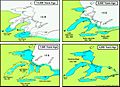
Development of the Great Lakes following the end of the Last Glacial Period. The first human settlers arrived in the area 11,000 to 10,500 years ago, as the glaciers retreated from the area.
-
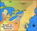
Hopewell Interaction Area around the eastern Great Lakes during the Middle Woodland period (100 BCE to 500). Present-day Toronto was situated in the Point Peninsula local expression of the Hopewellian exchange system.
-

A map of the region, with Ganatsekwyagon and other areas highlighted along the Rouge Trail, c. 1673. Teiaiagon is shown west Ganatsekwyagon.
-
In the 17th century, the area was a crucial point for travel, with the Humber and Rouge River providing a shortcut to the upper Great Lakes. These routes were known as the Toronto Passage.
-

Fort Rouillé was one of several French trading posts established in Toronto during the 1750s. The forts were abandoned in 1759 as a result of the Seven Years' War.
-
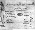
Signatures of the parties that ratified the 1805 indenture to the Toronto Purchase, an agreement initially made in 1787.
-
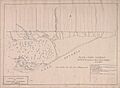
John Graves Simcoe's plans for York harbour, 1793.
-
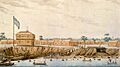
Constructed in 1793, Fort York was located at the entrance of a bay formed by the Toronto Islands.
-
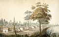
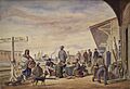
King Street in 1804. Later renamed Front Street, the road was one of York's original streets.
-
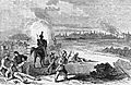
The American naval squadron exchange fire with Fort York during the Battle of York in April 1813. The American landing is depicted to the west (left foreground).
-
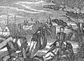
U.S. Army Brig. Gen. Zebulon Pike mortally wounded near the end of the Battle of York, struck by debris from an explosion set off at Fort York.
-
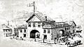
The second St. Lawrence Market building, opened in 1831.
-
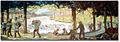
People celebrating the incorporation of Toronto. In 1834, the Town of York was incorporated as the new City of Toronto.
-
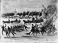
In 1837, a revolutionary insurrection was crushed by British authorities and Canadian volunteer units at Montgomery's Tavern on Yonge Street.
-
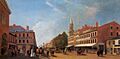
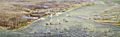
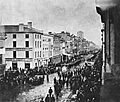
View of Toronto looking west from King and Jarvis in 1845. The buildings right of the trees were later destroyed in the Great Fire of 1849.
-
The construction of Union Station in 1858 dramatically increased commerce as well as the number of immigrants.
-
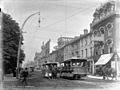
Horse-drawn streetcars in downtown Toronto in 1890.
-
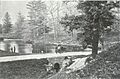
McCaul Pond at the University of Toronto campus, created from a dammed Taddle Creek, 1870.
-
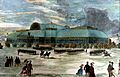
The Crystal Palace at the grounds of the Toronto Industrial Exhibition, 1871
-
An Orange Order parade on King Street, c. 1870. The fraternal organization, originally made up of Irish Protestant immigrants, became a dominant force in Toronto during the late 19th century.
-
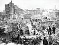
The Great Fire of Toronto of 1904 was a large fire that destroyed much of Downtown Toronto.
-
Construction for the Prince Edward Viaduct in 1916.
-
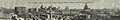
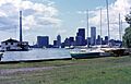
Toronto skyline in July 1930.
-
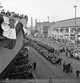
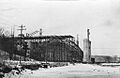
In 1944, the 1,000th Canadian-built vessel since the start of World War II was launched in Toronto. During the war, most of the city's industries were converted for war-time production.
-
In 1954, Hurricane Hazel swept through Toronto, causing significant flooding and damage.
-
The opening for the fourth Toronto City Hall in 1965. The modernist design of the building have made it a landmark of the city.
-
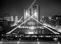
Skyline of downtown Toronto in 1973. Construction for the CN Tower is visible in the left background.
-
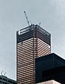
Construction of First Canadian Place, the operational headquarters of the Bank of Montreal, in 1975. The 1970s saw several Canadian financial institutions move to Toronto.
-
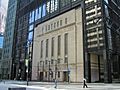
The former Toronto Stock Exchange building incorporated into the Toronto-Dominion Centre. The city began to designate heritage buildings in the 1970s, forcing some developers to incorporate them in their designs.
-
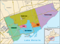
Municipalities of Metropolitan Toronto prior to its dissolution. In 1998, the six municipalities were dissolved and amalgamated, forming the new city of Toronto.
-
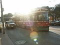
A TTC streetcar is left stranded after the city lost power in the Northeast blackout of 2003.
-

Official photo of world leaders at the 2010 G20 Toronto summit.
-
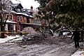
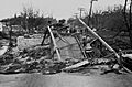
Damage from a fallen tree after the December 2013 North American storm complex passed through Toronto.
See also
- History of Ontario
- History of neighbourhoods in Toronto
- History of the Jews in Toronto
- List of historic places in Toronto
- List of lost buildings and structures in Toronto
- List of National Historic Sites of Canada in Toronto
- List of oldest buildings and structures in Toronto
- Timeline of Toronto history
