
List of longest streams of Idaho facts for kids
Idaho is a state in the United States known for its beautiful natural landscapes, including many rivers and streams. These waterways are very important for the environment, wildlife, and even for people living in Idaho.
There are seventy streams in Idaho that are at least 50 miles (80 kilometers) long! Most of these streams start right in Idaho. However, two big rivers, the Kootenai River (which is the third-longest) and the Moyie River (the thirty-first-longest), actually begin in British Columbia, Canada, before flowing into Idaho.
The longest river in Idaho is the mighty Snake River. It stretches for an amazing 1,076 miles (1,731 kilometers) in total! The Snake River starts in Wyoming, flows through Idaho for 769 miles (1,238 kilometers), and then continues through Oregon and Washington. Other rivers also cross borders with states like Montana, Nevada, Oregon, Utah, Washington, or Wyoming. But many of Idaho's rivers stay entirely within the state. The longest river that flows only in Idaho is the Salmon River, which is 425 miles (684 kilometers) long.
Most of Idaho's streams are part of the huge Columbia River system. This means their water eventually flows northwest towards the Columbia River, which then empties into the Pacific Ocean. Even though the Columbia River itself doesn't flow through Idaho, it's connected to many of Idaho's waterways.
Another important water system in Idaho is the Great Salt Lake watershed, found in the southeastern part of the state. This area is special because its rivers don't flow to the ocean. Instead, their water collects in the Great Salt Lake. The Bear River, which is the second-longest stream in Idaho, is part of this unique system. Other rivers in this area include the Malad River, Deep Creek, and the Logan River.
Contents
- Idaho's Longest Rivers: A Closer Look
- The Snake River: Idaho's Longest Waterway
- The Bear River: A Unique Inland Journey
- The Kootenai River: Flowing from Canada
- The Salmon River: The "River of No Return"
- The Owyhee River: A Desert Gem
- The Clark Fork: Connecting Idaho to Montana
- The Palouse River: Waterfalls and History
- The Bruneau River: Deep Canyons and Wildlife
- The Saint Joe River: A Wild and Scenic River
- Longest Streams of Idaho
- Map
- Images for kids
- See also
Idaho's Longest Rivers: A Closer Look
Let's explore some of the longest and most important rivers in Idaho. These rivers play a big role in shaping the state's geography and supporting its ecosystems.
The Snake River: Idaho's Longest Waterway
The Snake River is the longest river connected to Idaho. It's a huge river that travels through several states. In Idaho, the Snake River carves out deep canyons and provides water for farming and cities. It's also a popular spot for fishing and boating.
The Bear River: A Unique Inland Journey
The Bear River is the second-longest river in Idaho. What makes it special is that it's part of an endorheic basin. This means its water doesn't reach the ocean. Instead, it flows into the Great Salt Lake in Utah. The Bear River is important for wildlife and provides water for communities in southeastern Idaho.
The Kootenai River: Flowing from Canada
The Kootenai River is the third-longest river that touches Idaho. It starts in Canada and flows south into Idaho before turning north again into Montana and back into Canada. This river is known for its beautiful scenery and is a habitat for many fish species.
The Salmon River: The "River of No Return"
The Salmon River is the longest river that flows entirely within Idaho. It's sometimes called the "River of No Return" because of its fast currents and challenging rapids. This river is famous for its salmon runs, where salmon swim upstream to lay their eggs. It's also a popular destination for whitewater rafting and fishing.
The Owyhee River: A Desert Gem
The Owyhee River is the fifth-longest river. It flows through a rugged, remote desert landscape in southwestern Idaho and into Oregon. The Owyhee Canyonlands are known for their stunning rock formations and are home to unique plants and animals adapted to the desert environment.
The Clark Fork: Connecting Idaho to Montana
The Clark Fork is the sixth-longest river. It flows from Montana into Idaho, where it empties into Pend Oreille Lake. This river is a major tributary to the Columbia River system and is important for both recreation and hydroelectric power.
The Palouse River: Waterfalls and History
The Palouse River is the seventh-longest river. It flows through a region known as the Palouse, famous for its rolling hills and rich farmland. The river is also home to the spectacular Palouse Falls in Washington, a popular natural landmark.
The Bruneau River: Deep Canyons and Wildlife
The Bruneau River is the eighth-longest river in Idaho. It flows through deep, narrow canyons in southwestern Idaho. These canyons are home to various wildlife, including birds of prey, and offer unique opportunities for exploring the rugged Idaho landscape.
The Saint Joe River: A Wild and Scenic River
The Saint Joe River is the ninth-longest river. It flows through the beautiful Saint Joe National Forest in northern Idaho. This river is known for its clear waters and is a designated "Wild and Scenic River," meaning it's protected for its natural beauty and recreational value.
Longest Streams of Idaho
Here is a list of the longest streams that flow through Idaho. The table shows their rank, name, where they empty, their total length, and how much of that length is within Idaho.
| Rank | Name | Mouth | Total length | Length in Idaho | Mouth coordinates | Source coordinates | ||
|---|---|---|---|---|---|---|---|---|
| mi | km | mi | km | |||||
| 1 | Snake River | Columbia River | 1,076 | 1,732 | 769 | 1,238 | 46°11′10″N 119°01′43″W / 46.18611°N 119.02861°W | 44°07′49″N 110°13′10″W / 44.13028°N 110.21944°W |
| 2 | Bear River | Great Salt Lake | 490 | 789 | 185 | 297 | 41°27′30″N 112°17′25″W / 41.45833°N 112.29028°W | 40°52′02″N 110°50′09″W / 40.86722°N 110.83583°W |
| 3 | Kootenai River | Columbia River | 485 | 780 | 65 | 105 | 49°19′00″N 117°39′04″W / 49.31667°N 117.65111°W | 51°02′21″N 116°26′33″W / 51.03917°N 116.44250°W |
| 4 | Salmon River | Snake River | 425 | 685 | 425 | 685 | 45°51′23″N 116°47′37″W / 45.85639°N 116.79361°W | 43°47′48″N 114°46′36″W / 43.79667°N 114.77667°W |
| 5 | Owyhee River | Snake River | 347 | 558 | 91 | 147 | 43°48′46″N 117°01′32″W / 43.81278°N 117.02556°W | 41°30′17″N 115°44′30″W / 41.50472°N 115.74167°W |
| 6 | Clark Fork | Pend Oreille Lake | 347 | 558 | 9 | 15 | 48°11′00″N 116°16′09″W / 48.18333°N 116.26917°W | 46°11′12″N 112°46′18″W / 46.18667°N 112.77167°W |
| 7 | Palouse River | Snake River | 167 | 268 | 43 | 70 | 46°35′24″N 118°12′55″W / 46.59000°N 118.21528°W | 46°58′07″N 116°27′32″W / 46.96861°N 116.45889°W |
| 8 | Bruneau River | Snake River | 153 | 246 | 94 | 152 | 42°56′57″N 115°57′43″W / 42.94917°N 115.96194°W | 41°34′42″N 115°24′50″W / 41.57833°N 115.41389°W |
| 9 | Saint Joe River | Coeur d'Alene Lake | 140 | 225 | 140 | 225 | 47°23′35″N 116°45′15″W / 47.39306°N 116.75417°W | 47°01′07″N 115°04′58″W / 47.01861°N 115.08278°W |
| 10 | Big Wood River | Malad River | 137 | 221 | 137 | 221 | 42°56′42″N 114°47′44″W / 42.94500°N 114.79556°W | 43°51′38″N 114°42′48″W / 43.86056°N 114.71333°W |
| 11 | Big Lost River | Big Lost River Sinks | 135 | 217 | 135 | 217 | 43°47′39″N 112°50′26″W / 43.79417°N 112.84056°W | 43°56′01″N 114°06′38″W / 43.93361°N 114.11056°W |
| 12 | Blackfoot River | Snake River | 135 | 217 | 135 | 217 | 43°07′38″N 112°30′22″W / 43.12722°N 112.50611°W | 42°50′22″N 111°18′32″W / 42.83944°N 111.30889°W |
| 13 | North Fork Clearwater River | Clearwater River | 135 | 217 | 135 | 217 | 46°30′00″N 116°19′50″W / 46.50000°N 116.33056°W | 47°00′11″N 115°06′16″W / 47.00306°N 115.10444°W |
| 14 | Little Wood River | Malad River | 130 | 209 | 130 | 209 | 42°56′42″N 114°47′46″W / 42.94500°N 114.79611°W | 43°45′41″N 114°00′13″W / 43.76139°N 114.00361°W |
| 15 | Henrys Fork | Snake River | 127 | 204 | 127 | 204 | 43°45′10″N 111°57′28″W / 43.75278°N 111.95778°W | 44°29′34″N 111°16′58″W / 44.49278°N 111.28278°W |
| 16 | South Fork Owyhee River | Owyhee River | 127 | 204 | 33 | 53 | 42°15′55″N 116°53′17″W / 42.26528°N 116.88806°W | 41°13′40″N 116°09′39″W / 41.22778°N 116.16083°W |
| 17 | Portneuf River | Snake River | 124 | 200 | 124 | 200 | 42°57′06″N 112°45′02″W / 42.95167°N 112.75056°W | 43°06′10″N 112°00′13″W / 43.10278°N 112.00361°W |
| 18 | Goose Creek | Snake River | 123 | 197 | 75 | 120 | 42°32′37″N 113°45′47″W / 42.54361°N 113.76306°W | 42°10′29″N 114°17′31″W / 42.17472°N 114.29194°W |
| 19 | Salmon Falls Creek | Snake River | 121 | 195 | 73 | 117 | 42°42′55″N 114°51′12″W / 42.71528°N 114.85333°W | 41°47′22″N 114°57′43″W / 41.78944°N 114.96194°W |
| 20 | Pend Oreille River | Columbia River | 118 | 190 | 32 | 52 | 49°00′14″N 117°37′04″W / 49.00389°N 117.61778°W | 48°15′30″N 116°32′04″W / 48.25833°N 116.53444°W |
| 21 | Spokane River | Columbia River | 114 | 183 | 15 | 24 | 47°53′38″N 118°20′03″W / 47.89389°N 118.33417°W | 47°40′41″N 117°07′34″W / 47.67806°N 117.12611°W |
| 22 | Raft River | Snake River | 109 | 175 | 98 | 158 | 42°36′20″N 113°14′26″W / 42.60556°N 113.24056°W | 41°56′34″N 113°43′37″W / 41.94278°N 113.72694°W |
| 23 | Middle Fork Salmon River | Salmon River | 106 | 170 | 106 | 170 | 45°17′50″N 114°35′36″W / 45.29722°N 114.59333°W | 44°26′57″N 115°13′51″W / 44.44917°N 115.23083°W |
| 24 | North Fork Payette River | Payette River | 106 | 170 | 106 | 170 | 44°05′06″N 116°06′57″W / 44.08500°N 116.11583°W | 45°10′47″N 115°59′37″W / 45.17972°N 115.99361°W |
| 25 | Weiser River | Snake River | 103 | 166 | 103 | 166 | 44°14′19″N 116°58′20″W / 44.23861°N 116.97222°W | 45°01′13″N 116°26′05″W / 45.02028°N 116.43472°W |
| 26 | Boise River | Snake River | 102 | 164 | 102 | 164 | 43°49′15″N 117°01′34″W / 43.82083°N 117.02611°W | 43°42′48″N 115°38′09″W / 43.71333°N 115.63583°W |
| 27 | South Fork Boise River | Boise River | 102 | 164 | 102 | 164 | 43°36′06″N 115°51′25″W / 43.60167°N 115.85694°W | 43°46′25″N 114°55′45″W / 43.77361°N 114.92917°W |
| 28 | Selway River | Middle Fork Clearwater River | 100 | 161 | 100 | 161 | 46°08′25″N 115°35′58″W / 46.14028°N 115.59944°W | 45°29′49″N 114°44′37″W / 45.49694°N 114.74361°W |
| 29 | Jordan Creek | Owyhee River | 99 | 159 | 42 | 67 | 42°51′45″N 117°38′29″W / 42.86250°N 117.64139°W | 42°58′21″N 116°44′39″W / 42.97250°N 116.74417°W |
| 30 | Malad River | Bear River | 97 | 156 | 36 | 58 | 41°35′10″N 112°07′03″W / 41.58611°N 112.11750°W | 42°13′18″N 112°21′54″W / 42.22167°N 112.36500°W Note: Incomplete record. Source coordinates derived from Big Malad Spring. |
| 31 | Moyie River | Kootenai River | 92 | 147 | 26 | 42 | 48°42′56″N 115°11′11″W / 48.71556°N 115.18639°W | 49°17′00″N 116°09′00″W / 49.28333°N 116.15000°W |
| 32 | South Fork Salmon River | Salmon River | 90 | 145 | 90 | 145 | 45°22′40″N 115°30′47″W / 45.37778°N 115.51306°W | 44°28′47″N 115°41′06″W / 44.47972°N 115.68500°W |
| 33 | Willow Creek | Snake River | 84 | 136 | 84 | 136 | 43°33′10″N 111°59′17″W / 43.55278°N 111.98806°W | 43°05′40″N 111°42′52″W / 43.09444°N 111.71444°W |
| 34 | Salt River | Snake River | 84 | 136 | 2 | 4 | 43°10′02″N 111°03′52″W / 43.16722°N 111.06444°W | 42°35′38″N 110°48′08″W / 42.59389°N 110.80222°W |
| 35 | Payette River | Snake River | 83 | 133 | 83 | 133 | 44°05′32″N 116°57′09″W / 44.09222°N 116.95250°W | 44°05′04″N 116°06′54″W / 44.08444°N 116.11500°W |
| 36 | Teton River | Henrys Fork | 81 | 131 | 81 | 131 | 43°53′56″N 111°50′21″W / 43.89889°N 111.83917°W | 43°36′38″N 111°09′16″W / 43.61056°N 111.15444°W |
| 37 | South Fork Payette River | Payette River | 80 | 129 | 80 | 129 | 44°05′04″N 116°06′54″W / 44.08444°N 116.11500°W | 43°57′51″N 115°00′02″W / 43.96417°N 115.00056°W |
| 38 | Hangman Creek | Spokane River | 79 | 127 | 21 | 33 | 47°39′36″N 117°27′28″W / 47.66000°N 117.45778°W | 47°06′53″N 116°43′00″W / 47.11472°N 116.71667°W |
| 39 | North Fork Coeur d'Alene River | Coeur d'Alene River | 77 | 124 | 77 | 124 | 47°33′26″N 116°15′22″W / 47.55722°N 116.25611°W | 48°00′03″N 116°18′27″W / 48.00083°N 116.30750°W |
| 40 | Clearwater River | Snake River | 75 | 120 | 75 | 120 | 46°25′30″N 117°02′14″W / 46.42500°N 117.03722°W | 46°08′45″N 115°58′57″W / 46.14583°N 115.98250°W |
| 41 | Deep Creek | Great Salt Lake | 73 | 118 | 35 | 57 | 41°41′42″N 113°00′26″W / 41.69500°N 113.00722°W | 42°21′40″N 112°35′41″W / 42.36111°N 112.59472°W |
| 42 | Union Flat Creek | Palouse River | 72 | 115 | 5 | 7 | 46°49′38″N 117°59′55″W / 46.82722°N 117.99861°W | 46°31′20″N 116°57′35″W / 46.52222°N 116.95972°W |
| 43 | Succor Creek | Snake River | 71 | 114 | 30 | 48 | 43°37′55″N 116°56′47″W / 43.63194°N 116.94639°W | 43°05′45″N 116°50′18″W / 43.09583°N 116.83833°W |
| 44 | Lochsa River | Middle Fork Clearwater River | 69 | 111 | 69 | 111 | 46°08′25″N 115°35′58″W / 46.14028°N 115.59944°W | 46°30′30″N 114°40′54″W / 46.50833°N 114.68167°W |
| 45 | Priest River | Pend Oreille River | 68 | 110 | 68 | 110 | 48°10′37″N 116°53′34″W / 48.17694°N 116.89278°W | 48°45′58″N 116°51′52″W / 48.76611°N 116.86444°W |
| 46 | Battle Creek | Owyhee River | 67 | 108 | 67 | 108 | 42°14′14″N 116°31′29″W / 42.23722°N 116.52472°W | 42°44′32″N 116°24′16″W / 42.74222°N 116.40444°W |
| 47 | Bannock Creek | Snake River | 67 | 107 | 67 | 107 | 42°53′14″N 112°41′02″W / 42.88722°N 112.68389°W | 42°22′56″N 112°38′36″W / 42.38222°N 112.64333°W |
| 48 | Indian Creek | Boise River | 66 | 107 | 66 | 107 | 43°40′39″N 116°42′19″W / 43.67750°N 116.70528°W | 43°25′53″N 115°46′49″W / 43.43139°N 115.78028°W |
| 49 | Sailor Creek | Snake River | 64 | 104 | 64 | 104 | 42°55′43″N 115°28′48″W / 42.92861°N 115.48000°W | 42°22′52″N 115°12′59″W / 42.38111°N 115.21639°W |
| 50 | Fall River | Henrys Fork | 64 | 103 | 33 | 53 | 44°01′07″N 111°34′52″W / 44.01861°N 111.58111°W | 44°14′51″N 110°45′43″W / 44.24750°N 110.76194°W |
| 51 | Camas Creek | Big Wood River | 64 | 103 | 64 | 103 | 43°19′36″N 114°24′06″W / 43.32667°N 114.40167°W | 43°15′28″N 115°20′57″W / 43.25778°N 115.34917°W |
| 52 | Camas Creek | Mud Lake | 63 | 102 | 63 | 102 | 43°53′24″N 112°21′32″W / 43.89000°N 112.35889°W | 44°21′52″N 111°53′36″W / 44.36444°N 111.89333°W |
| 53 | South Fork Clearwater River | Clearwater River | 63 | 101 | 63 | 101 | 46°08′45″N 115°58′57″W / 46.14583°N 115.98250°W | 45°48′30″N 115°28′29″W / 45.80833°N 115.47472°W |
| 54 | Sheep Creek | Bruneau River | 63 | 101 | 61 | 97 | 42°29′55″N 115°35′50″W / 42.49861°N 115.59722°W | 41°58′18″N 115°55′07″W / 41.97167°N 115.91861°W |
| 55 | Chief Eagle Eye Creek | Payette River | 61 | 98 | 61 | 98 | 43°56′16″N 116°22′01″W / 43.93778°N 116.36694°W | 44°26′10″N 116°09′09″W / 44.43611°N 116.15250°W |
| 56 | Little Owyhee River | South Fork Owyhee River | 61 | 97 | 16 | 26 | 42°10′03″N 116°52′19″W / 42.16750°N 116.87194°W | 41°48′30″N 117°17′03″W / 41.80833°N 117.28417°W |
| 57 | Lemhi River | Salmon River | 60 | 97 | 60 | 97 | 45°11′17″N 113°54′23″W / 45.18806°N 113.90639°W | 44°40′56″N 113°21′17″W / 44.68222°N 113.35472°W |
| 58 | Pahsimeroi River | Salmon River | 59 | 95 | 59 | 95 | 44°41′31″N 114°02′55″W / 44.69194°N 114.04861°W | 44°09′25″N 113°42′15″W / 44.15694°N 113.70417°W |
| 59 | Beaver Creek | Camas Creek | 58 | 94 | 58 | 94 | 43°59′21″N 112°14′19″W / 43.98917°N 112.23861°W | 44°30′23″N 112°21′26″W / 44.50639°N 112.35722°W |
| 60 | Big Jacks Creek | Jacks Creek | 58 | 93 | 58 | 93 | 42°47′12″N 115°58′41″W / 42.78667°N 115.97806°W | 42°22′56″N 116°06′29″W / 42.38222°N 116.10806°W |
| 61 | Potlatch River | Clearwater River | 57 | 92 | 57 | 92 | 46°28′31″N 116°46′02″W / 46.47528°N 116.76722°W | 46°55′43″N 116°20′55″W / 46.92861°N 116.34861°W |
| 62 | Marsh Creek | Portneuf River | 56 | 90 | 56 | 90 | 42°47′40″N 112°15′28″W / 42.79444°N 112.25778°W | 42°24′12″N 112°01′37″W / 42.40333°N 112.02694°W |
| 63 | Clover Creek | Bruneau River | 55 | 89 | 55 | 89 | 42°34′35″N 115°38′07″W / 42.57639°N 115.63528°W | 42°09′28″N 115°12′43″W / 42.15778°N 115.21194°W |
| 64 | Logan River | Little Bear River | 54 | 86 | 3 | 5 | 41°44′29″N 111°57′17″W / 41.74139°N 111.95472°W | 42°02′07″N 111°35′58″W / 42.03528°N 111.59944°W |
| 65 | Blue Creek | Owyhee River | 53 | 85 | 53 | 85 | 42°01′48″N 116°12′37″W / 42.03000°N 116.21028°W | 42°32′05″N 116°16′04″W / 42.53472°N 116.26778°W |
| 66 | Middle Fork Boise River | Boise River | 52 | 84 | 52 | 84 | 43°42′48″N 115°38′08″W / 43.71333°N 115.63556°W | 43°56′47″N 115°01′56″W / 43.94639°N 115.03222°W |
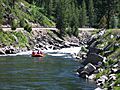
| 67 | Little Salmon River | Salmon River | 52 | 84 | 52 | 84 | 45°25′00″N 116°18′53″W / 45.41667°N 116.31472°W | 44°50′28″N 116°15′46″W / 44.84111°N 116.26278°W |
| 68 | Jarbidge River | Bruneau River | 52 | 83 | 34 | 54 | 42°19′45″N 115°39′09″W / 42.32917°N 115.65250°W | 41°46′47″N 115°22′37″W / 41.77972°N 115.37694°W |
| 69 | Cow Creek | Jordan Creek | 51 | 82 | 13 | 20 | 42°56′51″N 117°20′38″W / 42.94750°N 117.34389°W | 43°04′23″N 116°50′23″W / 43.07306°N 116.83972°W |
| 70 | North Fork Boise River | Boise River | 50 | 81 | 50 | 81 | 43°42′49″N 115°38′08″W / 43.71361°N 115.63556°W | 44°05′41″N 115°13′37″W / 44.09472°N 115.22694°W |
Map
Images for kids
-
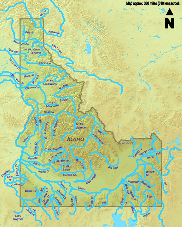
The Snake River (longest) cutting through the Snake River Plain near Twin Falls
-
Bear River (2nd longest) in Bear River State Park, Wyoming
-
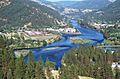
Kootenai River (3rd longest) south of Libby Dam, Montana
-
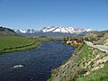
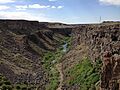
Salmon River (4th longest) below the Sawtooth Mountains
-
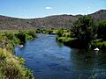
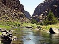
Owyhee River (5th longest) south of Mountain City, Nevada
-
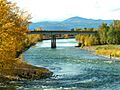
Clark Fork (6th longest) in Missoula, Montana
-
Palouse River (7th longest) flowing over Palouse Falls, Washington
-
Bruneau River (8th longest) in southwestern Idaho
-
Saint Joe River (9th longest) in the Saint Joe National Forest
-
North Fork Clearwater River (13th longest) below Dworshak Dam
-
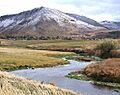
Portneuf River (17th longest) west of Soda Springs
-
Salmon Falls Creek (19th longest) below Salmon Falls Dam
-
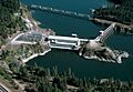
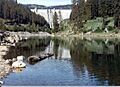
Pend Oreille River (20th longest) at Albeni Falls Dam
-
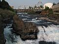
Spokane River (21st longest) in downtown Spokane, Washington
-
North Fork Payette River (24th longest) near Smiths Ferry
-
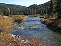
Weiser River (25th longest) near Weiser
-
Boise River (26th longest) near Boise
-
Clearwater River (40th longest) near Orofino
-
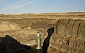
Succor Creek (43rd longest) in Malheur County, Oregon


See also
