
National Register of Historic Places listings in Missouri facts for kids

This article is about the amazing historic places and areas in Missouri that are listed on the National Register of Historic Places. This special list helps protect important buildings, sites, and districts across the United States. Missouri has places on this list in all of its 114 counties and also in the independent city of St. Louis.
Contents
- What is the National Register of Historic Places?
- Discovering Missouri's Historic Treasures
- Andrew County's Historic Spots
- Audrain County's Notable Places
- Barton County: Harry S Truman's Birthplace
- Bates County's Historic Buildings and Bridges
- Benton County's Ancient and Modern History
- Bollinger County: Will Mayfield College
- Caldwell County: Far West and its Courthouse
- Cedar County's Mills and Community Buildings
- Christian County's Historic Square and Shelters
- Clinton County: Stoutimore House
- Dade County: Opera House and Hotel
- Dallas County: Bennett Spring State Park
- Daviess County's Unique Jail
- DeKalb County's Historic Homes and Courthouse
- Douglas County: Ava Ranger Station
- Gentry County's Public Buildings
- Harrison County's Historic Houses
- Hickory County: Quincy Public Hall
- Holt County's Transportation and Church History
- Knox County: Edina Double Square
- Lawrence County's Courthouses and Archeological Sites
- Livingston County: Chillicothe's Historic Districts
- Maries County: Jail and Sheriff's House
- McDonald County's Old Courthouse and Bridges
- Mercer County's Historic Homes
- Morgan County: Hotels, Churches, and Homes
- Oregon County: Greer Mill
- Ozark County: Historic Mills and Houses
- Polk County: Bolivar's Historic Buildings
- Putnam County: Unionville Square
- Randolph County: Moberly's Commercial History
- Reynolds County: Civil War Fortifications
- St. Clair County: Schools
- Schuyler County: Railroad and Homes
- Scotland County: Schools and Homes
- Shelby County: Historic Districts and Homes
- Stoddard County: Courthouses and Archeology
- Stone County: Unique Bridges and Courthouses
- Wayne County: Forts and Parks
- Webster County: Farms and Funeral Homes
- Worth County: Courthouse
- Images for kids
What is the National Register of Historic Places?
The National Register of Historic Places (NRHP) is the official list of places in the United States that are important to history. It's like a hall of fame for buildings, structures, objects, sites, and even whole neighborhoods! When a place is added to the NRHP, it means it's recognized for its special history, architecture, or culture. This helps protect these places for future generations to enjoy and learn from.
Why are places added to the NRHP?
Places get on the NRHP for many reasons. They might be:
- Where important historical events happened.
- Homes or workplaces of famous people.
- Great examples of a certain type of building style.
- Places that tell us about how people lived long ago.
- Sites with important archaeological finds.
What is a Historic District?
Sometimes, it's not just one building that's important, but a whole area! A historic district is a group of buildings, structures, or sites that are all connected by history or design. For example, a street with many old, beautiful houses from the same time period might become a historic district. This helps keep the unique look and feel of that area.
Discovering Missouri's Historic Treasures
Missouri is full of history, from its early days as a frontier state to its role in American industry and culture. Many places across the state are on the National Register. Let's look at a few examples from different counties to see the variety of historic sites Missouri has.
Andrew County's Historic Spots
Andrew County has some interesting places on the NRHP.
- The Andrew County Courthouse in Savannah is a beautiful old building that has been important to the county for many years.
- The J. F. Roberts Octagonal Barn near Rea is a unique, eight-sided barn. It's a cool example of different farm building styles from the past.
- The Walnut Park Farm Historic District near St. Joseph is a historic area that shows what old farms were like.
Audrain County's Notable Places
Audrain County also has its share of historic sites.
- The Audrain County Courthouse in Mexico is another important government building that has served the community for a long time.
- The Lincoln School in Vandalia is a historic school building. Schools often tell us about how education and communities grew over time.
- The Ross House in Mexico is a historic home, showing how people lived in the past.
- The Arthur Simmons Stables Historic District in Mexico highlights the area's connection to horses and stables, which was a big part of life in earlier times.
Barton County: Harry S Truman's Birthplace
One very special place in Barton County is the Harry S Truman Birthplace Memorial in Lamar. This is the house where Harry S. Truman, who became the 33rd President of the United States, was born. It's a simple home that reminds us that even presidents start somewhere!
Bates County's Historic Buildings and Bridges
Bates County has several historic sites, including:
- The Bates County Courthouse in Butler, another grand building that tells the story of local government.
- The Hudson City School near Appleton City, showing an old school building.
- The Palace Hotel in Butler, a historic hotel that once welcomed travelers.
- The Papinville Marais des Cygnes River Bridge, an old bridge that was important for travel and trade across the river.
Benton County's Ancient and Modern History
Benton County offers a mix of very old and more recent history.
- The Rodgers Shelter Archeological Site near Fristoe is an ancient site where archaeologists have found clues about early human life in Missouri. This helps us understand people who lived thousands of years ago!
- The Central Cole Camp Historic District and the Augustus Sander House in Cole Camp show us what towns and homes looked like in the past.
- The Upper Bridge in Warsaw is an old bridge over the Osage River, important for transportation.
Bollinger County: Will Mayfield College
In Bollinger County, the Will Mayfield College Arts and Science Building and the larger Will Mayfield College Campus in Marble Hill are listed. This college campus now houses the Bollinger County Museum of Natural History, showing how historic places can be reused for new purposes.
Caldwell County: Far West and its Courthouse
Caldwell County has the Caldwell County Courthouse in Kingston. Also, the historic site of Far West near Kingston is important. Far West was a significant settlement in Missouri's early history.
Cedar County's Mills and Community Buildings
Cedar County features the Caplinger Mills Historic District, which includes an old mill and bridge. Mills were vital for communities long ago. The Stockton Community Building in Stockton is another historic spot, showing where people gathered. There's also the Montgomery Archeological Site, which is a restricted site, meaning its exact location is kept secret to protect its ancient treasures.
Christian County's Historic Square and Shelters
In Christian County, the Ozark Courthouse Square Historic District in Ozark is a central part of the town's history. The Southwest Missouri Prehistoric Rock Shelter and Cave Sites Discontiguous Archeological District near Chadwick is a collection of very old rock shelters and caves. These sites give us clues about how prehistoric people lived in the area.
Clinton County: Stoutimore House
Clinton County has the David L. and Sallie Ann Stoutimore House in Plattsburg, a historic home that tells a story about the people who lived there.
Dade County: Opera House and Hotel
Dade County features the Greenfield Opera House Building and the Washington Hotel in Greenfield. Opera houses were once major entertainment centers, and hotels were key stops for travelers. An interesting note is the Dilday Mill, which was once listed but later removed because it collapsed. This shows that sometimes historic places can be lost.
Dallas County: Bennett Spring State Park
Dallas County has two listings within Bennett Spring State Park: the Bennett Spring State Park Hatchery-Lodge Area Historic District and the Bennett Spring State Park Shelter House and Water Gauge Station. State parks often have historic structures built long ago to help people enjoy nature.
Daviess County's Unique Jail
Daviess County has its Daviess County Courthouse and the A. Taylor Ray House in Gallatin. What's really unique is the Daviess County Rotary Jail and Sheriff's Residence. A rotary jail is a very rare type of jail where cells could be rotated like a carousel!
DeKalb County's Historic Homes and Courthouse
DeKalb County has the Dalton-Uphoff House and the Absolom Riggs House, both historic homes. The DeKalb County Courthouse in Maysville is also on the list.
Douglas County: Ava Ranger Station
In Douglas County, the Ava Ranger Station Historic District near Ava is listed. This shows the history of how our national forests were managed. Like Christian County, it also shares part of the Southwest Missouri Prehistoric Rock Shelter and Cave Sites Discontiguous Archeological District.
Gentry County's Public Buildings
Gentry County has several public buildings on the list in Albany, including the Albany Carnegie Public Library (a library built with money from Andrew Carnegie), the Gentry County Courthouse, and the Samuel and Pauline Peery House. The Opera Hall Block in King City was another place for community events and performances.
Harrison County's Historic Houses
Harrison County has the Hamilton House and the Slatten House in Bethany, both historic homes.
Hickory County: Quincy Public Hall
Hickory County features the Quincy Public Hall in Quincy, a place where the community would gather. The John Siddle Williams House near Hermitage is also listed.
Holt County's Transportation and Church History
Holt County has the Chicago, Burlington and Quincy Depot in Mound City, an old train station important for transportation history. The City Hall in Forest City is also listed. The Rulo Bridge near Fortescue was a historic bridge over the Missouri River, but it was demolished in 2014. This reminds us that some historic structures are no longer standing. The St. John's Evangelical Lutheran Church and Parochial School in Corning shows the history of religious and educational buildings.
Knox County: Edina Double Square
Knox County has the Edina Double Square Historic District in Edina. A "double square" town plan is pretty unique and shows how towns were designed long ago.
Lawrence County's Courthouses and Archeological Sites
Lawrence County has the Lawrence County Courthouse and the Pierce City Fire Station, Courthouse and Jail in Pierce City. The Old Spanish Fort Archeological Site near Mount Vernon is another ancient site that tells us about early inhabitants. The Lewis Shaw Coleman House and the Lawrence County Bank Building are also listed.
Livingston County: Chillicothe's Historic Districts
Livingston County has several historic districts in Chillicothe, including the Chillicothe Commercial Historic District and the Courthouse Square Historic District. These areas show how the town's businesses and government developed. The Chillicothe Industrial Home for Girls and the Grace Episcopal Church and Building are also important historic structures.
Maries County: Jail and Sheriff's House
In Maries County, the Maries County Jail and Sheriff's House in Vienna is listed. This building gives us a look into the history of law enforcement and daily life in the past.
McDonald County's Old Courthouse and Bridges
McDonald County has the Old McDonald County Courthouse in Pineville, a significant building for the county's history. The Pineville Site is a restricted archaeological site. The Powell Bridge near Powell is another historic bridge.
Mercer County's Historic Homes
Mercer County has the Herbert Cain and Corah Brantley Casteel House and the Leo Ellis Post No. 22, American Legion Building in Princeton.
Morgan County: Hotels, Churches, and Homes
Morgan County has the Martin Hotel and the Morgan County Courthouse in Versailles. The Old St. Patrick's Church near Gravois Mills is a historic church building. The Jesse Ratcliff House near Barnett is also listed.
Oregon County: Greer Mill
Oregon County has the Greer Mill near Alton, an old mill that was important for processing grains. The Pigman Mound Archeological Site is another restricted ancient site.
Ozark County: Historic Mills and Houses
Ozark County features the Hodgson-Aid Mill near Sycamore, a historic grist mill that used water power. The John Conkin and Clara Layton Harlin House in Gainesville is also listed.
Polk County: Bolivar's Historic Buildings
Polk County has several historic buildings in Bolivar, including the Bolivar Public Library (another Carnegie library), the First National Bank, and the North Ward School. The George Dimmitt Memorial Hospital in Humansville is also listed.
Putnam County: Unionville Square
In Putnam County, the Unionville Square Historic District in Unionville is listed. This district shows the historic center of the town.
Randolph County: Moberly's Commercial History
Randolph County has the Burkholder-O'Keefe House and the Moberly Junior High School in Moberly. The Moberly Commercial Historic District shows the history of businesses in the town. The Mitchell Petroglyph Archeological Site near Cairo is an ancient site with carvings in rock.
Reynolds County: Civil War Fortifications
Reynolds County has the Buford-Carty Farmstead near Black. A very interesting site is the Civil War Fortification at Barnesville near Ellington, which was a fort used during the American Civil War.
St. Clair County: Schools
St. Clair County has the Harper School in Harper and the Osceola Public School Building in Osceola, both historic school buildings.
Schuyler County: Railroad and Homes
Schuyler County has the Downing Railroad Depot in Downing, an old train station. The William P. Hall House in Lancaster is also listed.
Scotland County: Schools and Homes
Scotland County has the Bible Grove Consolidated District No. 5 School in Bible Grove and the Rutledge School in Rutledge, showing the history of education. The Downing House in Memphis is a historic home.
Shelby County: Historic Districts and Homes
Shelby County has the Benjamin House in Shelbina. In Bethel, there's the Bethel Historic District, and two other historic places called Elim and Hebron. These places are important for understanding the history of the community.
Stoddard County: Courthouses and Archeology
Stoddard County has the Dexter Gymnasium in Dexter and the Stoddard County Courthouse in Bloomfield. The Mingo National Wildlife Refuge Archeology District and the Rich Wood Archeological Site near Bernie are important ancient sites.
Stone County: Unique Bridges and Courthouses
Stone County has the Levi Morrill Post Office and Homestead near Notch. The Stone County Courthouse in Galena is also listed. A very cool feature is the Y-Bridge in Galena, which is a bridge that splits into a "Y" shape. It also shares part of the Southwest Missouri Prehistoric Rock Shelter and Cave Sites Discontiguous Archeological District.
Wayne County: Forts and Parks
Wayne County has Fort Benton near Patterson, a historic fort. The Old Greenville (23WE637) site near Greenville is also listed. The Sam A. Baker State Park Historic District near Patterson highlights historic structures within the state park.
Webster County: Farms and Funeral Homes
Webster County has the Hosmer Dairy Farm Historic District near Marshfield, showing the history of farming. The Col. Thomas C. Love House near Seymour and the Rainey Funeral Home Building in Marshfield are also listed.
Worth County: Courthouse
Worth County has the Worth County Courthouse in Grant City, a central historic building for the county.
Images for kids
-
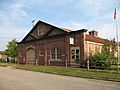
The Pony Express Stables in Buchanan County, a historic site related to the famous mail service.
-
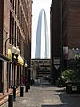
The Gateway Arch in St. Louis, a famous landmark.
-

The Missouri State Capitol building in Jefferson City.


