
Geography of the United Kingdom facts for kids
.jpg) |
|
| Continent | Europe |
|---|---|
| Region | Northwestern Europe |
| Coordinates | 54°0′N 2°30′W / 54.000°N 2.500°W |
| Area | Ranked 78th |
| • Total | 244,376 km2 (94,354 sq mi) |
| • Land | 99.3% |
| • Water | 0.7% |
| Coastline | 12,429 km (7,723 mi) |
| Borders | 499 km (310 mi) land border with Republic of Ireland |
| Highest point | Ben Nevis 1,345 m (4,413 ft) |
| Lowest point | The Fens −4 m (−13 ft) |
| Longest river | River Severn 354 km (220 mi) |
| Largest lake | Lough Neagh 392 km2 (151 sq mi) |
| Climate | Temperate, with some areas of Scotland being Tundra, and Subarctic |
| Terrain | Mountainous area to the north and west, lowland area to the south and east. |
| Natural resources | Coal, oil (continental shelf of the North Sea), natural gas, tin, limestone, iron, salt, clay, lead |
| Natural hazards | Storms, floods |
| Environmental issues | Biodiversity loss, sulphur dioxide emissions from power plants, some rivers are contaminated by agricultural waste, wastewater into the sea |
| Exclusive economic zone | In Europe: 773,676 km2 (298,718 sq mi) All overseas territories: 6,805,586 km2 (2,627,651 sq mi) |
| References | |
The United Kingdom (UK) is a country located off the northwest coast of Europe. It's made up of the island of Great Britain, the northeastern part of the island of Ireland, and many smaller islands around them. The UK is the world's 7th largest island country.
The UK is situated between the North Atlantic Ocean and the North Sea. It's very close to France, separated by the English Channel. A special underwater tunnel, the Channel Tunnel, connects the UK to France. The UK also shares a land border with the Republic of Ireland.
Contents
- Understanding the UK's Size and Shape
- Exploring the UK's Landscape
- People and Economy in the UK
- Natural Resources of the UK
- Protecting the Environment
- UK's Dependent Territories
- Images for kids
- See also
Understanding the UK's Size and Shape
The total area of the United Kingdom is about 244,376 square kilometres (94,354 sq mi). This includes Great Britain, Northern Ireland, and many smaller islands. This makes it the 7th largest island country in the world.
How Big Are the UK's Countries?
The UK is made up of four countries: England, Scotland, Wales, and Northern Ireland.
- England is the largest country in the UK. It covers about 130,462 square kilometres (50,372 sq mi), which is more than half of the UK's total area.
- Scotland is the second largest, with an area of about 78,801 square kilometres (30,425 sq mi). This is about a third of the UK's size.
- Wales and Northern Ireland are smaller. Wales covers 20,783 square kilometres (8,024 sq mi) and Northern Ireland covers 14,330 square kilometres (5,530 sq mi).
To give you an idea, the UK's land area is similar to countries like Uganda or Romania. It's the 80th largest country by land area in the world.
Exploring the UK's Landscape

The UK has a very diverse landscape, meaning it looks different in different places.
England's Varied Terrain
Most of England has flat or gently rolling land. You'll find hills and mountains mainly in the northwest. Famous hilly areas include the Lake District, the Pennines, and Dartmoor. The flatter parts often have low chalk hills and wide plains.
Scotland's Mountains and Lowlands
Scotland is the most mountainous country in the UK. A special line called the Highland Boundary Fault divides Scotland into two main parts:
- The Scottish Highlands in the north and west are mostly mountainous.
- The Scottish Lowlands in the south and east have flatter land, especially in the middle.
Wales' Hilly Beauty
Wales is mostly mountainous. North and mid-Wales are more rugged than south Wales.
Northern Ireland's Rolling Hills
Northern Ireland has a mostly hilly landscape. It's home to the Mourne Mountains and Lough Neagh, which is the largest lake in the UK by surface area.
How Was the UK's Land Formed?
The UK's landscape was shaped by powerful forces over millions of years. These include the movement of Earth's plates (tectonics) and big changes in climate, especially glaciation (when huge ice sheets covered parts of the land).
The tallest mountain in the UK is Ben Nevis in Scotland. The longest river is the River Severn, which flows through Wales and England.
The UK's Amazing Geology

The rocks and landforms of the UK are very complex and diverse. This is because the area has been affected by many plate tectonic processes over a very long time. Imagine continents crashing together, volcanoes erupting, and sea levels changing! This history has created the rich variety of landscapes we see today.
- Ancient Rocks: The oldest rocks in the UK are found in northwest Scotland. They are over 2.7 billion years old!
- Continents Collide: Millions of years ago, what is now the UK was split between different continents. These continents slowly moved and crashed into each other. These collisions created huge mountain ranges, like the ancient Caledonian Orogeny mountains in north and west Britain.
- Volcanoes and Seas: At different times, parts of the UK were covered by shallow seas or had active volcanoes. The remains of these volcanoes can still be seen in places like the Lake District.
- Coal and Oil: About 360 million years ago, the UK was near the equator, covered by warm, shallow seas and swamps. This is when the Coal Measures were formed, which gave Britain its huge coal reserves. Later, the burial of tiny sea creatures led to the formation of North Sea oil and natural gas.
- Ice Ages: Over the last 2 million years, several ice ages dramatically changed the landscape. Huge ice sheets, sometimes 1,000 meters thick, carved out valleys and fjords, like those in Scotland. They also moved giant rocks far from their original locations.
Today, Scotland is still slowly rising because the weight of the ice has been lifted. Southern and eastern England are slowly sinking.
Tallest Mountains and Hills

The ten tallest mountains in the UK are all in Scotland. Here are the highest peaks in each part of the UK:
- Scotland: Ben Nevis, 1,345 metres (4,413 ft) (4,413 ft)
- Wales: Snowdon (Yr Wyddfa), (Snowdonia), 1,085 metres (3,560 ft) (3,560 ft)
- England: Scafell Pike (Cumbrian Mountains), 978 metres (3,209 ft) (3,209 ft)
- Northern Ireland: Slieve Donard (Mourne Mountains), 852 metres (2,795 ft) (2,795 ft)
The lowest point in the UK is in the Fens of East Anglia, England. Some parts are as much as 4 metres (13 ft) (13 ft) below sea level.
Rivers and Lakes
The longest river in the UK is the River Severn, which is 220 mi (350 km). It flows through both Wales and England.
Here are the longest rivers found entirely within each UK country:
- England: River Thames (215 mi (346 km))
- Scotland: River Tay (117 mi (188 km))
- Northern Ireland: River Bann (76 mi (122 km))
- Wales: River Usk (78 mi (126 km))
The largest lakes by surface area in each country are:
- Northern Ireland: Lough Neagh (147.39 sq mi (381.7 km2))
- Scotland: Loch Lomond (27.46 sq mi (71.1 km2))
- England: Windermere (5.69 sq mi (14.7 km2))
- Wales: Bala Lake (Llyn Tegid) (1.87 sq mi (4.8 km2))
The deepest lake in the UK is Loch Morar in Scotland, which is 309 metres (1,014 ft) (1,014 ft) deep. Loch Ness is the UK's largest lake by volume.
Canals and Reservoirs
Because of its industrial past, the UK has many canals. These were mostly built during the early Industrial Revolution to transport goods. The UK also has many dams and reservoirs to store water for drinking and industry.
The UK's Coastline

The UK has a long coastline, measuring about 12,429 km (7,723 mi). Because the coast is so indented (has many bays and inlets), no place in the UK is more than 125 km (78 mi) from the sea.
The UK also has a very large Exclusive Economic Zone (EEZ) around its shores. This is an area where the country has special rights over marine resources. Including its overseas territories, the UK's EEZ is the 5th largest in the world!
Interesting Coastal Features
The UK's coastline has many interesting features:
- Bays and Estuaries: Cardigan Bay, Bristol Channel, Thames Estuary, Morecambe Bay, Firth of Forth.
- Headlands: Many rocky points stick out into the sea, like the White Cliffs of Dover.
- Tidal Flats: These are muddy or sandy areas exposed at low tide. The UK has a significant amount of tidal flats.
Islands of the UK
The UK is made up of over a thousand small islands! Most of these are off the north and west coasts of Scotland. About 130 of them are inhabited.
- The largest island in the UK is Great Britain.
- The largest islands in each country are:
- Scotland: Lewis and Harris (841 sq mi (2,180 km2))
- Wales: Anglesey (276 sq mi (710 km2))
- England: Isle of Wight (147 sq mi (380 km2))
- Northern Ireland: Rathlin Island (6 sq mi (16 km2))
The UK's Climate
The UK generally has a temperate climate, which means it has mild temperatures and rainfall throughout the year. However, the weather can vary a lot depending on how high up you are and how close you are to the coast. The south of the country is usually warmer than the north, and the west is wetter than the east.
The UK is warmer than other places at the same latitude (distance from the equator) because of the warming influence of the Gulf Stream, a warm ocean current.
- Rainfall: Annual rainfall varies greatly. The Scottish Highlands can get over 3,000 mm (118.1 in) of rain, while Cambridge gets only about 553 mm (21.8 in).
- Temperatures: The highest temperature ever recorded in the UK was 40.3 °C (104.5 °F) in Lincolnshire in July 2022. The lowest was −27.2 °C (−17.0 °F) in Scotland.
People and Economy in the UK


The way people live and work in the UK is shaped by its long history as a trading nation and its industrial past.
Where People Live and Work
The UK led the Industrial Revolution, which means it was one of the first countries to develop factories and modern industries. This is why many of its major cities grew up around manufacturing centers like Birmingham, Glasgow, London, and Manchester.
- Past Industries: The UK's main industry used to be coal mining, especially in the north and Midlands. Most of this has now stopped.
- Current Industries: Today, a major primary industry is North Sea oil, found off the northeast coast of Scotland.
- Manufacturing: While heavy manufacturing has changed, areas like the English Midlands and the North West still have important manufacturing bases.
- Finance and Services: The UK's financial industry is mostly in London, which is one of the world's biggest financial centers. Many other cities also have important service industries.
Regional Differences
The UK has what's often called a "North-South divide." This means that older industrial areas in Northern England, Scotland, and Wales can be less wealthy than the finance and technology-focused economy in the south. Governments try to help balance these differences. However, it's not always simple; some wealthy areas are in the north, and some poorer areas are in the south.
Natural Resources of the UK
The UK has many natural resources.
- Forests: Historically, much of the UK was covered in forests, but a lot of it has been cut down over time.
- Farming: Farming in the UK is very efficient and uses modern machines. It produces about 60% of the food the country needs. Most of this is for livestock (animals) and arable crops (plants grown in fields).
- Underground Resources: The UK has important geological resources like coal, petroleum (oil), natural gas, limestone, iron ore, and tin.
- Energy Potential: Because it's an island, the UK has great potential for generating electricity from wave power and tidal power, though these are not yet widely used.
Protecting the Environment
Environmental Challenges
England is one of the most densely populated countries in Europe. This high population, combined with a changing climate, puts pressure on the UK's water resources.
The UK is working to reduce its greenhouse gas emissions, which contribute to climate change. It has met international targets for reducing emissions. The UK also aims to recycle more household waste.
A survey in 2018 showed that the UK is one of the most "nature-depleted" countries in the world. This means it has lost a lot of its natural wildlife and habitats.
Working with Other Countries
The UK is part of many international agreements to protect the environment. These include agreements on air pollution, climate change, protecting endangered species, and conserving marine life.
UK's Dependent Territories
.svg)
The UK also has several Crown Dependencies and British Overseas Territories. These are places that are linked to the UK but have their own governments. Their geography is covered in their own articles.
- Crown Dependencies:
- Geography of the Isle of Man
- Geography of the Channel Islands (like Geography of Jersey and Geography of Guernsey)
- Overseas Territories:
- Geography of Anguilla
- Geography of Bermuda
- British Antarctic Territory
- Geography of the Falkland Islands
- Geography of Gibraltar
- Geography of Saint Helena, Ascension and Tristan da Cunha
- Turks and Caicos Islands
Images for kids
-
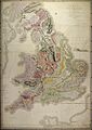
1815 geological map by William Smith

See also
 In Spanish: Geografía del Reino Unido para niños
