Geography of Ireland facts for kids
 |
|
| Continent | Europe |
|---|---|
| Region | Northwestern Europe |
| Area | |
| • Total | 84,421 km2 (32,595 sq mi) |
| • Land | 98.2% |
| • Water | 1.8% |
| Coastline | 7,524 km (4,675 mi) |
| Highest point | Carrauntoohil 1,039 metres (3,409 ft) |
| Lowest point | North Slob −3 metres (−10 ft) |
| Longest river | River Shannon 360.5 km (224.0 mi) |
| Largest lake | Lough Neagh 392 km2 (151 sq mi) |
| Climate | temperate oceanic climate with some upland areas classified as oceanic subpolar |
| Terrain | flat, low-lying area in the midlands, ringed by mountain ranges |
| Natural resources | aquaculture, fertile soil, freshwater, timber, peat, bauxite, copper, zinc, lead, gold, silver, iron, gypsum, natural gas, hydropower, wind energy |
| Natural hazards | Cyclones, flooding, thunderstorms |
| Environmental issues | Water pollution, Leaching, Climate change, Waste disposal |
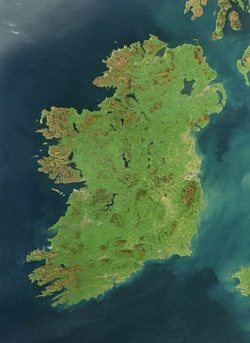
Ireland is a beautiful island in Northern Europe, located in the north Atlantic Ocean. It's about 480 km (300 mi) long from north to south and 275 km (171 mi) wide from east to west. The island is part of the Eurasian Plate, which is a huge piece of Earth's crust.
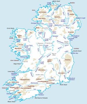
Ireland's main features include flat, low-lying areas in the middle, surrounded by coastal mountains. The highest mountain is Carrauntoohil, standing tall at 1,039 metres (3,409 ft) above sea level. The western coast is rugged with many islands and bays, while the southern and northern coasts have fewer large sea inlets. No part of Ireland is more than about 110 km (68 mi) from the sea.
The island is almost divided by the River Shannon, which is the longest river in Ireland at 360.5 km (224 mi). It flows from County Cavan in the north to the Atlantic Ocean near Limerick. Along its path, the Shannon forms the border between different parts of Ireland. There are also many large lakes, with Lough Neagh being the biggest.
Politically, Ireland is split into two main parts. The Republic of Ireland covers about five-sixths of the island. The remaining sixth is Northern Ireland, which is part of the United Kingdom. Ireland is located west of Great Britain and has a total area of 84,421 km2 (32,595 sq mi). It's separated from Great Britain by the Irish Sea and from mainland Europe by the Celtic Sea.
Ireland has a mild, humid, and changeable temperate oceanic climate. This means it has warm summers and mild winters. It's warmer than other places at the same latitude because of the Atlantic Ocean's winds and currents. The island is not very forested, but it has a strong farming industry. It has some mineral resources and has found natural gas, but not much oil. Renewable energy, like hydropower and wind power, is becoming more common.
Contents
How Ireland's Land Was Formed
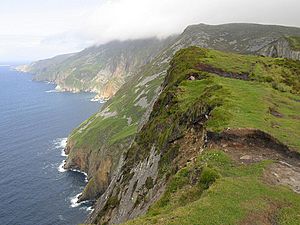
The land of Ireland has a very interesting and varied history. Different parts of the country have rocks from different time periods, some as old as 1.7 billion years! The oldest rocks are found on Inishtrahull Island and at Annagh Head. Newer landforms, like drumlins (small hills shaped by glaciers) and valleys, were created by the last ice age.
Ireland was actually formed from two separate pieces of land that slowly joined together about 440 million years ago. Over millions of years, the land has been shaped by volcanoes, tropical seas, and huge sheets of ice during the last glacial period. The movement of Earth's plates and the ice ages caused the sea level to rise and fall many times.
Because of these different events, Ireland has many types of soil. You can find large areas of bogs (wetlands with peat) and fertile brown soils. The mountains are made of different rocks like granite, sandstone, and limestone. The powerful glaciers of the last ice age smoothed out the landscape, creating the beautiful scenery we see today.
Ireland's Physical Features
Mountains and Hills
The middle part of Ireland, called the Midlands, is mostly flat and low. This flat area is surrounded by mountain ranges. If you start in County Cork and go clockwise around the island, you'll find ranges like the MacGillycuddy's Reeks, Wicklow Mountains, and Mourne Mountains. Some mountains are further inland, like the Galtee Mountains, which are the highest inland range.
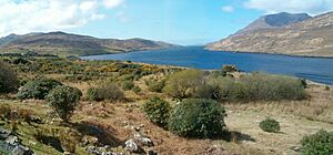
The highest peak in Ireland is Carrauntoohil, which is 1,038.6 m (3,407 ft) tall. It's part of the MacGillycuddy's Reeks, which are sandstone mountains carved by glaciers. Only three peaks on the island are over 1,000 m (3,300 ft), but many others are over 500 m (1,600 ft). There are many walking trails in the mountains, including a long one through the Wicklow Mountains. In the Mourne Mountains, there's even a 36-kilometre-long (22 mi) wall built between 13 major peaks!
Ireland is often called the "Emerald Isle" because of its very green landscape.
Rivers and Lakes
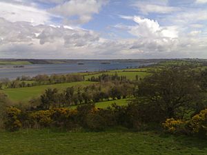
Water covers about 2% of Ireland's land area. The Republic of Ireland has over 74,000 kilometres (46,000 mi) of rivers and streams and more than 125,000 hectares (310,000 acres) of lakes. Counties Cork, Donegal, and Mayo have a lot of rivers, while Mayo and Galway have most of the lakes.
The River Shannon is the longest river in Ireland and Britain, measuring 360.5 kilometres (224.0 mi) long. Its basin, the area it drains, covers one-fifth of the island. The Shannon flows through 11 counties and forms a natural boundary between the west and the south/east of Ireland. Along its way, it forms three large lakes: Lough Allen, Lough Ree, and Lough Derg. The Shannon finally flows into the Atlantic Ocean at Limerick.
Other important rivers include the River Liffey (which flows through Dublin), the River Slaney, and the "Three Sisters" (the Rivers Nore, Suir, and Barrow). There are also several rivers called Blackwater, with the Munster Blackwater being the most important.
Lough Neagh, located in Ulster, is the largest lake in Ireland and Britain, covering 392 km2 (151 sq mi). The largest lake in the Republic of Ireland is Lough Corrib, at 176 km2 (68 sq mi).
Sea Inlets
Ireland's coastline has many interesting inlets, which are narrow strips of sea reaching into the land. In County Donegal, Lough Swilly separates the western part of the Inishowen peninsula. On the other side, Lough Foyle is a large inlet between County Donegal and County Londonderry.
Moving clockwise around the coast, you'll find Belfast Lough and Strangford Lough in County Down. Further south, Carlingford Lough is between Down and County Louth.
On the east coast, Dublin Bay is a notable inlet. The south coast features Waterford Harbour and Cork Harbour, which is a very large natural harbor.
Along the western coast, there are many bays between the peninsulas of western County Cork and County Kerry, such as Dunmanus Bay and Dingle Bay. The Shannon Estuary is also a major inlet. Further north, you'll find Galway Bay and Clew Bay in County Mayo. Donegal Bay is a large inlet between County Donegal and County Sligo.
Headlands and Extreme Points
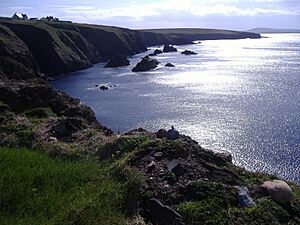
A headland is a narrow piece of land that sticks out into the sea. Malin Head is the most northerly point in Ireland, and Mizen Head is one of the most southern points. This is why people sometimes say "from Malin to Mizen" to mean the whole island of Ireland. Carnsore Point is the southeasternmost point. Other well-known headlands include Hook Head and the Old Head of Kinsale on the south coast, and Loop Head in County Clare.
Islands and Peninsulas
Achill Island, off the west coast, is the largest of Ireland's offshore islands. People live there, and it's connected to the mainland by a bridge. The Aran Islands, off the coast of southern Connacht, are also large and are home to an Irish-speaking community called a Gaeltacht. Valentia Island is another large island, connected by a bridge. Omey Island is a tidal island, meaning you can walk to it at low tide.
Some of Ireland's most famous peninsulas are in Counties Cork and Kerry, including the Dingle peninsula, the Iveragh peninsula, and the Beara peninsula. The Inishowen peninsula in County Donegal is home to Malin Head, Ireland's most northerly point.
The most northerly undisputed land feature of Ireland is Inishtrahull island. Rockall Island lies even farther north, but its ownership is debated by several countries. The most southerly point of Ireland is the Fastnet Rock.
Forests in Ireland
Ireland, like Great Britain, was once covered in thick forests. However, people started clearing these forests a long time ago, and this sped up after the Tudor conquest of Ireland. By the early 1900s, only about 1% of the land was forested. As of 2017, about 11% of the Republic of Ireland's land had tree cover, but only 2% was native forest in 2018. This is one of the lowest percentages in Europe.
Coastal Waters
The coastline of Ireland is 7,524 kilometres (4,675 mi) long. The land under the sea, called the continental shelf, extends far to the west and southwest. This means the Republic of Ireland has claims to a huge area of seabed, more than 10 times its land area, covering over 880,000 square kilometres (340,000 sq mi).
Ireland's Climate
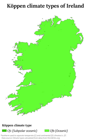
Ireland has a mild, humid, and changeable climate with plenty of rain and not many extreme temperatures. It's known as a temperate oceanic climate. This is the same type of climate found in most of northwest Europe. Ireland has generally warm summers and mild winters. It's much warmer than other places at the same latitude, like Newfoundland in Canada, because it's downwind of the Atlantic Ocean and benefits from warm ocean currents like the North Atlantic Current and Gulf Stream. For example, Dublin is about 9°C warmer than St. John's, Newfoundland, in winter.
The warm ocean currents also keep Ireland's coastline free of ice all winter. Ireland doesn't usually experience extreme weather like tornadoes. However, it can be affected by cyclones that move eastward from the North Atlantic.
The wind usually comes from the southwest, hitting the high mountains on the west coast first. This means the west of Ireland gets a lot of rain. For example, Valentia Island on the west coast gets more than twice as much rain as Dublin on the east coast (1,557 mm or 61.3 in vs. 714 mm or 28.1 in).
The average temperature in Ireland (from 1990–2020) is 9.8 °C (49.6 °F). January and February are the coldest months, with average daily temperatures around 5.3 to 5.5 °C (41.5 to 41.9 °F). July and August are the warmest, with average daily temperatures of 15 to 15.2 °C (59.0 to 59.4 °F). The sunniest months are May and June, with about five to seven hours of sunshine per day.
While extreme weather is rare, it does happen. Strong winds of up to 160 km/h or 99 mph can hit western coastal areas in winter. In summer, especially in late July or early August, thunderstorms can occur.
The tables below show average climate data for Ireland's two largest cities, Dublin and Belfast.
| Climate data for Dublin Airport (DUB), 1991–2020 normals, extremes 1881–present | |||||||||||||
|---|---|---|---|---|---|---|---|---|---|---|---|---|---|
| Month | Jan | Feb | Mar | Apr | May | Jun | Jul | Aug | Sep | Oct | Nov | Dec | Year |
| Record high °C (°F) | 18.5 (65.3) |
18.1 (64.6) |
23.6 (74.5) |
22.7 (72.9) |
26.8 (80.2) |
32.3 (90.1) |
33.0 (91.4) |
30.6 (87.1) |
27.6 (81.7) |
24.2 (75.6) |
19.4 (66.9) |
18.1 (64.6) |
33.0 (91.4) |
| Mean daily maximum °C (°F) | 8.0 (46.4) |
8.5 (47.3) |
10.1 (50.2) |
12.3 (54.1) |
14.8 (58.6) |
17.7 (63.9) |
19.5 (67.1) |
19.1 (66.4) |
16.9 (62.4) |
13.6 (56.5) |
10.3 (50.5) |
8.3 (46.9) |
13.3 (55.9) |
| Daily mean °C (°F) | 5.2 (41.4) |
5.3 (41.5) |
6.6 (43.9) |
8.2 (46.8) |
10.7 (51.3) |
13.3 (55.9) |
15.4 (59.7) |
15.1 (59.2) |
13.2 (55.8) |
10.4 (50.7) |
7.3 (45.1) |
5.5 (41.9) |
9.7 (49.5) |
| Mean daily minimum °C (°F) | 2.3 (36.1) |
2.2 (36.0) |
3.0 (37.4) |
4.0 (39.2) |
6.6 (43.9) |
9.0 (48.2) |
11.3 (52.3) |
11.2 (52.2) |
9.5 (49.1) |
7.1 (44.8) |
4.3 (39.7) |
2.6 (36.7) |
6.1 (43.0) |
| Record low °C (°F) | −15.6 (3.9) |
−13.4 (7.9) |
−9.8 (14.4) |
−7.2 (19.0) |
−5.6 (21.9) |
−0.7 (30.7) |
1.8 (35.2) |
0.6 (33.1) |
−1.7 (28.9) |
−5.6 (21.9) |
−9.3 (15.3) |
−15.7 (3.7) |
−15.7 (3.7) |
| Average precipitation mm (inches) | 61.8 (2.43) |
52.4 (2.06) |
51.4 (2.02) |
55.0 (2.17) |
57.0 (2.24) |
64.0 (2.52) |
61.0 (2.40) |
73.4 (2.89) |
63.3 (2.49) |
78.4 (3.09) |
82.7 (3.26) |
72.1 (2.84) |
772.5 (30.41) |
| Average precipitation days (≥ 1.0 mm) | 12.5 | 11.0 | 10.7 | 11.1 | 10.5 | 9.8 | 11.6 | 11.8 | 10.7 | 11.6 | 12.5 | 13.3 | 137.1 |
| Average snowy days | 3.2 | 3.2 | 2.4 | 0.7 | 0.1 | 0.0 | 0.0 | 0.0 | 0.0 | 0.0 | 0.6 | 2.3 | 12.5 |
| Average relative humidity (%) (at 15:00 UTC) | 81.6 | 76.9 | 71.6 | 68.7 | 67.8 | 67.7 | 69.0 | 69.8 | 71.9 | 75.8 | 81.6 | 83.9 | 73.9 |
| Average dew point °C (°F) | 3.2 (37.8) |
3.0 (37.4) |
3.6 (38.5) |
4.8 (40.6) |
7.1 (44.8) |
9.7 (49.5) |
11.6 (52.9) |
11.6 (52.9) |
10.2 (50.4) |
7.8 (46.0) |
5.5 (41.9) |
3.8 (38.8) |
6.8 (44.3) |
| Mean monthly sunshine hours | 60.2 | 81.8 | 121.0 | 165.9 | 197.3 | 180.1 | 158.3 | 155.4 | 129.4 | 105.9 | 73.5 | 56.6 | 1,485.4 |
| Mean daily daylight hours | 8.2 | 9.9 | 11.9 | 14.0 | 15.9 | 16.9 | 16.4 | 14.7 | 12.7 | 10.5 | 8.6 | 7.6 | 12.3 |
| Average ultraviolet index | 0 | 1 | 2 | 4 | 5 | 6 | 6 | 5 | 4 | 2 | 1 | 0 | 3 |
| Source 1: Met Éireann | |||||||||||||
| Source 2: NOAA(dew point) WeatherAtlas (Daylight hours and UV Index) | |||||||||||||
| Climate data for Belfast International Airport, elevation: 63 m (207 ft), 1991–2020 normals, extremes 1958–present | |||||||||||||
|---|---|---|---|---|---|---|---|---|---|---|---|---|---|
| Month | Jan | Feb | Mar | Apr | May | Jun | Jul | Aug | Sep | Oct | Nov | Dec | Year |
| Record high °C (°F) | 14.0 (57.2) |
15.6 (60.1) |
20.2 (68.4) |
21.8 (71.2) |
25.0 (77.0) |
29.5 (85.1) |
30.0 (86.0) |
28.0 (82.4) |
25.6 (78.1) |
21.8 (71.2) |
16.4 (61.5) |
15.0 (59.0) |
30.0 (86.0) |
| Mean daily maximum °C (°F) | 7.3 (45.1) |
7.9 (46.2) |
9.7 (49.5) |
12.3 (54.1) |
15.2 (59.4) |
17.6 (63.7) |
19.1 (66.4) |
18.7 (65.7) |
16.6 (61.9) |
13.1 (55.6) |
9.8 (49.6) |
7.6 (45.7) |
12.9 (55.2) |
| Daily mean °C (°F) | 4.7 (40.5) |
4.9 (40.8) |
6.3 (43.3) |
8.5 (47.3) |
11.2 (52.2) |
13.8 (56.8) |
15.4 (59.7) |
15.2 (59.4) |
13.2 (55.8) |
10.2 (50.4) |
7.1 (44.8) |
5.0 (41.0) |
9.6 (49.3) |
| Mean daily minimum °C (°F) | 2.1 (35.8) |
2.0 (35.6) |
3.0 (37.4) |
4.7 (40.5) |
7.1 (44.8) |
9.9 (49.8) |
11.8 (53.2) |
11.7 (53.1) |
9.9 (49.8) |
7.2 (45.0) |
4.4 (39.9) |
2.4 (36.3) |
6.4 (43.5) |
| Record low °C (°F) | −12.8 (9.0) |
−11.1 (12.0) |
−9.9 (14.2) |
−5.1 (22.8) |
−2.8 (27.0) |
−1.2 (29.8) |
2.2 (36.0) |
2.3 (36.1) |
−0.5 (31.1) |
−3.0 (26.6) |
−8.6 (16.5) |
−14.9 (5.2) |
−14.9 (5.2) |
| Average precipitation mm (inches) | 77.0 (3.03) |
63.3 (2.49) |
60.6 (2.39) |
55.6 (2.19) |
55.9 (2.20) |
68.0 (2.68) |
78.8 (3.10) |
84.5 (3.33) |
69.2 (2.72) |
88.0 (3.46) |
87.7 (3.45) |
83.5 (3.29) |
872.0 (34.33) |
| Average precipitation days (≥ 1.0 mm) | 14.7 | 13.2 | 13.0 | 12.0 | 11.6 | 11.9 | 14.1 | 14.2 | 12.1 | 14.0 | 15.5 | 15.2 | 161.3 |
| Average snowy days | 5 | 5 | 4 | 1 | 0 | 0 | 0 | 0 | 0 | 0 | 1 | 3 | 19 |
| Average relative humidity (%) | 89 | 87 | 88 | 89 | 90 | 90 | 90 | 92 | 92 | 91 | 90 | 89 | 91 |
| Mean monthly sunshine hours | 48.7 | 72.1 | 108.4 | 157.8 | 197.9 | 167.6 | 152.0 | 146.4 | 121.5 | 91.2 | 61.3 | 47.1 | 1,372 |
| Source 1: Met Office NOAA (relative humidity and snow days 1961–-1990) | |||||||||||||
| Source 2: KNMI | |||||||||||||
Ireland's Natural Resources
Bogs and Peat
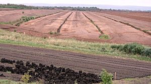
Ireland has a huge amount of bog land, about 12,000 km2. There are two main types: blanket bogs and raised bogs.
Raised bogs are less common and are mostly found in the Shannon river area. They formed after the ice age when lakes filled with water. Over time, plant debris built up at the bottom, eventually filling the lakes and rising above the surface to form these bogs.
Blanket bogs are more common and were largely created by human activity, helped by Ireland's moist climate. They formed in areas where early farmers cleared trees for farming. When these lands were no longer used, the soil became more acidic, perfect for plants like heather and rushes. The dead plants then built up, forming a layer of peat. One of the largest areas of blanket bog is in County Mayo.
How Bogs Are Used and Why They Are Important
For centuries, people have cut peat from bogs to use as fuel for heating and cooking. This is called "turf." In the 1940s, machines made it possible to harvest peat on a much larger scale. In the Republic of Ireland, a company called Bord na Móna was in charge of this. Besides home use, commercially harvested peat is used to make peat briquettes for fuel and milled peat for generating electricity. More recently, peat is being mixed with biomass to produce electricity.
However, the destruction of bogs has become an environmental concern. Raised bogs, in particular, have been heavily mined because they provide higher-quality fuel. Now, there are plans in both the Republic and Northern Ireland to protect most of the remaining raised bogs on the island.
Oil, Natural Gas, and Minerals
Ireland is the biggest European producer of zinc. The Tara Mine is Europe's largest and deepest active mine for zinc and lead. Other valuable minerals found in Ireland include gold, silver, gypsum, and limestone.
Natural Gas and Oil Discoveries
Companies started looking for natural gas offshore in 1970. The first big discovery was the Kinsale Head gas field in 1971. Later, the smaller Ballycotton gas field (1989) and the Corrib gas field (1996) were found. Gas from these fields is brought to shore and used for homes and industries.
Oil fields have also been discovered, like the Helvick oil field in 2000 and Barryroe in 2012. While these fields contain a lot of oil, they haven't been used yet. In 2007, a government report suggested that there might be huge amounts of oil and natural gas in Irish waters, potentially worth trillions of Euros. There are also gas and oil deposits on land, such as in the Lough Allen basin.
In 2012, the first commercial oil well was drilled off the Cork coast. This was a big moment for Ireland's oil and gas industry. However, in 2023, the government decided not to approve further drilling for the Barryroe field, so it might not be developed.
Renewable Energy Sources
In 2009, the Republic of Ireland aimed to get 16% of its energy from renewable sources by 2020. This target was later increased to 32% by 2030. By 2020, Ireland reached 13.5% of its energy from renewable sources, falling a bit short of the 2020 goal. Renewable electricity made up most of this renewable energy.
Wind Power
While hydropower was the main renewable energy source in the 20th century, wind power has grown a lot in the 21st century, driven by concerns about climate change.
The first Irish wind farm, Bellacorick, was built in 1992. Its turbines were much smaller than today's. As of 2022, the Republic of Ireland has over 300 wind farms. To meet future renewable energy goals, this number will need to double by 2030. Most of this energy will come from wind farms on land, as there is only one offshore wind farm, the Arklow Bank Wind Park.
New wind farm projects are being planned and built. For example, a floating wind farm off Northern Ireland was proposed for 2022. In 2023, a new wind farm in County Antrim started operating, with Amazon buying all the power it produces. Another project, the Carrowkeel Wind Farm in County Roscommon, is planned to power over 20,000 homes by 2028.
Solar Energy
According to a 2020 report, solar energy only contributed 1% of Ireland's renewable energy. Some people are concerned about how solar farms look, which can slow down projects. Experts also note that while solar electricity is cheap when available, it doesn't provide power on demand like other sources.
However, solar energy is growing. Since April 2022, a large solar farm near Ashford, County Wicklow has been producing energy for about 3,600 homes. It's the first big solar project in the Republic of Ireland. By the end of 2023, it's expected that the country will produce 1 gigawatt (GW) of solar power. A new €50 million solar panel scheme for schools in 11 counties should help schools save money on electricity.
The first ground-based solar farm on the island is in County Antrim. It's connected to Belfast International Airport and provides 27% of the airport's annual energy needs.
Hydroelectric Power
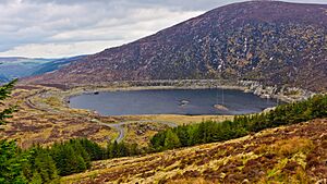
The first major hydroelectric power plant in Ireland, the Shannon hydroelectric scheme, was built in 1929, just seven years after Ireland became independent. It has a capacity of 86 megawatts (MW). This was followed by the much larger Turlough Hill Power Station, which is unique because it's built inside a mountain. Completed in 1974, it has a capacity of 292 MW. There are also a few other smaller hydroelectric stations in the Republic of Ireland. These four main hydro plants use about 70% of the country's water resources for power.
A tidal energy system has been working in Strangford Lough since 2008. It uses an underwater windmill to generate 1.2 MW of power from the tidal currents. This system can produce enough electricity for about 1,000 homes. Another tidal energy system, called Evopod, has been tested in Northern Ireland and is expected to connect to the electric grid.
See also
 In Spanish: Geografía de Irlanda para niños
 | Toni Morrison |
 | Barack Obama |
 | Martin Luther King Jr. |
 | Ralph Bunche |


