Geography of Wales facts for kids
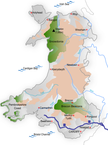
Map of Wales. Topography above 600 feet (182.88m) in pink; national parks in green.
|
|
 |
|
| Continent | Europe |
|---|---|
| Region | British Isles |
| Area | |
| • Total | 21,218 km2 (8,192 sq mi) |
| Highest point | Snowdon (Welsh: Yr Wyddfa) |
| Longest river | River Severn (Welsh: Afon Hafren) |
| Largest lake | Lake Vyrnwy (Welsh: Llyn Efyrnwy) |
| Climate | Temperate |
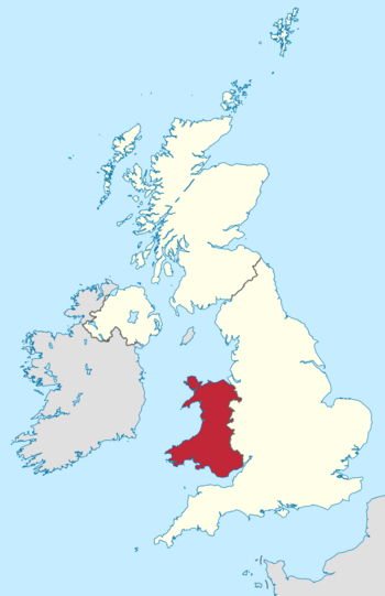
Wales is a country that is part of the United Kingdom. Its land has a varied coastline and lots of hills and mountains. To the east, Wales shares a border with England. The Irish Sea is to its north and west, and the Bristol Channel is to its south.
Wales covers about 2,064,100 hectares (5,101,000 acres) of land. It stretches about 170 mi (274 km) from north to south and is at least 60 mi (97 km) wide. This makes up about 8.35% of the United Kingdom's land. Wales also has several islands off its coast. The biggest one is Anglesey. The total coastline, including Anglesey, is about 1,680 mi (2,704 km) long. In 2014, about 3,092,000 people lived in Wales. Cardiff is the capital and largest city, located in South East Wales.
Wales has a long and interesting geological past, which has made it a very mountainous country. The flat land near the coast is narrow in the north and west. But it's wider in the south, especially in the Vale of Glamorgan, which has excellent farmland. During the Industrial Revolution, people mined a lot of coal from the South Wales Coalfield. This led to many towns growing in the South Wales Valleys. Port cities like Newport, Cardiff, and Swansea also grew to export coal. The smaller North Wales Coalfield was also developed. However, most of Wales is still rural, with small communities. The economy there mostly depends on farming and tourism. Wales's climate is mild, cloudy, wet, and windy. This is because it's close to the Atlantic Ocean and gets winds from the west.
Contents
Exploring Wales's Geography
Wales is located on the western side of Great Britain. The Irish Sea is to its north and west, and the Bristol Channel is to its south. To the east, Wales borders English counties like Cheshire, Shropshire, Herefordshire, and Gloucestershire. Much of the border with England follows an old earthwork called Offa's Dyke. The large island of Anglesey is off the northwest coast. It is separated from mainland Wales by the Menai Strait. There are also many smaller islands.
Mountains and Hills of Wales
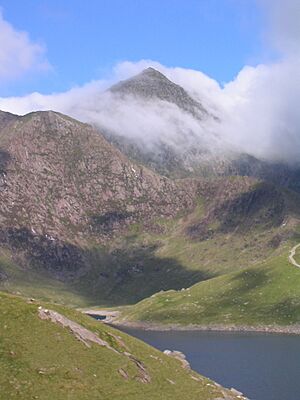
Most of Wales is mountainous. Snowdonia (Welsh: Eryri) in the northwest has the highest mountains. Snowdon (Yr Wyddfa) is the highest peak, standing at 1,085 m (3,560 ft). South of this main range are the Arenig Group, Cadair Idris, and the Berwyn Mountains. In northeast Wales, you'll find the Clwydian Range. There are 14 (or possibly 15) peaks over 3,000 feet (914 m), all in Snowdonia. These are known as the Welsh 3000s.
The Cambrian Mountains stretch from northeast to southwest. They cover most of central Wales. These mountains are more rounded and covered in moorland and rough grass. In the south, you'll find the Brecon Beacons in central Powys. The Black Mountains (Y Mynyddoedd Duon) are in parts of Powys and Monmouthshire. There's also Black Mountain (Y Mynydd Du), which is further west.
Lowlands and Rivers
The lowlands of Wales include the north coastal plain and the island of Anglesey. They also include parts of the Llŷn Peninsula, a narrow strip of coast along Cardigan Bay, and much of Pembrokeshire. Other lowland areas are southern Carmarthenshire, the Gower Peninsula, and the Vale of Glamorgan.
Many rivers flow through Wales. The River Dee forms part of the border with England. The River Clwyd and the River Conwy flow north into Liverpool Bay and the Irish Sea. Further along the coast, the Rivers Mawddach, Dovey, Rheidol, Ystwyth, and Teifi flow west into Cardigan Bay. The rivers Towy, Taff, Usk, and Wye flow south into the Bristol Channel. Parts of the River Severn also form the boundary between Wales and England.
Coastline and Lakes
The coastline of mainland Wales is about 1,370 mi (2,205 km) long. If you add the coasts of Anglesey and Holy Island, the total is about 1,680 mi (2,704 km). Cardigan Bay is the largest bay in Wales.
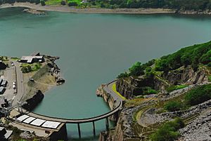
Bala Lake (Llyn Tegid) is the largest natural lake, covering 4.7 km2 (1.8 sq mi). It sits in a valley carved by glaciers. Other large lakes include Llyn Trawsfynydd, Lake Vyrnwy, Llyn Brenig, Llyn Celyn, and Llyn Alaw. Most of these other lakes are reservoirs. They were created by building dams across rivers to provide drinking water, generate electricity, or prevent floods. Many are also used for fun activities like boating.
Understanding Wales's Geology
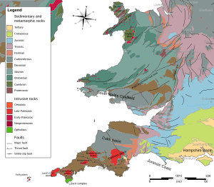
The geology of Wales is very complex and diverse. The oldest rocks you can see are from the Precambrian era, about 700 million years ago. These are found in Anglesey, the Llŷn peninsula, and parts of Pembrokeshire.
During the early Palaeozoic era, seas repeatedly covered and then left the land. This caused thousands of meters of sedimentary and volcanic rocks to build up in a deep area called the Welsh Basin. In 1977, some of Earth's oldest fossils were found in a quarry near Llangynog. These fossils are from the Ediacaran period, 564 million years ago. At that time, Wales was part of a small continent called Avalonia.
Volcanoes and Rock Formation
Between 485 and 460 million years ago, during the Ordovician period, there was a lot of volcanic activity. A huge volcano, now near Snowdon, erupted an estimated 60 cubic kilometres (14 cu mi) of ash and rock. Another volcano formed Rhobell Fawr near Dolgellau. During this time, large amounts of sand, gravel, and mud settled in southern Wales. These materials slowly turned into rock. Some volcanic ash fell into the sea, forming huge banks. Sometimes, these unstable masses would slide into deeper water, creating underwater avalanches. This made the sea very cloudy, and then particles settled based on their size. The layers of rock formed this way are called turbidites. You can see them clearly in the sea cliffs around Aberystwyth.
By the start of the Devonian period (420 million years ago), the sea was leaving the Welsh Basin. Land masses were colliding, pushing up a new mountain range called the Welsh Caledonides. The Old Red Sandstone rocks are made from the eroded material of these mountains. In other places, the rock layers were squeezed and bent. Some clay minerals changed, allowing the rocks to split into thin, flat sheets called slate.
In the early Carboniferous period, the sea returned to parts of southern and northern Wales, depositing limestone. Large swamps in South Wales formed peat deposits, which eventually became coal. Later in the period, erosion from nearby uplands created sandstones and mudstones. Southwestern Wales was especially affected by the Variscan orogeny. This was a time when continental collisions further south caused complex folding and breaking of the rock layers.
Ice Ages and Modern Landscape
During the Permian, Triassic, and Jurassic periods (300 to 150 million years ago), Wales experienced more changes. It was sometimes covered by the sea and sometimes raised above it. By the Cretaceous period (140 to 70 million years ago), Wales was permanently above sea level. In the Pleistocene epoch (2.5 million years ago to today), Wales went through several very cold periods, known as ice ages. The mountains we see today mostly got their shape during the last ice age, called the Devensian glaciation.
In the mid-1800s, two famous geologists, Roderick Murchison and Adam Sedgwick, studied the geology of Wales. Their work helped them create important rules for understanding rock layers (stratigraphy) and palaeontology (the study of fossils). The earliest geological period of the Paleozoic era, the Cambrian, was named after Cambria, the Latin name for Wales. After much debate, the next two periods, the Ordovician and Silurian, were named after ancient Celtic tribes of Wales, the Ordovices and Silures.
Wales's Climate and Weather
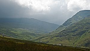
Wales has a maritime climate. This means its weather is strongly influenced by the sea. The main winds blow from the southwest and west, coming from the Atlantic Ocean. Because of this, the weather in Wales is generally mild, cloudy, wet, and windy.
The country's varied landscape causes local differences in sunshine, rainfall, and temperature. The highest average rainfall is in Snowdonia and the Brecon Beacons. The lowest is near the coast and in the east, close to England. Winter months are much wetter than summer months across Wales. Snow is rare near sea level but much more common in the hills. Upland areas have harsher winter conditions.
Temperatures and Rainfall
The average yearly temperature in Wales is about 11 °C (52 °F) on the coast and 9.5 °C (49 °F) in low-lying inland areas. It gets colder at higher altitudes, dropping about 0.5 °C (0.9 °F) for every 100 metres (330 feet) you go up. So, the highest parts of Snowdonia have an average yearly temperature of 5 °C (41 °F).
The coldest nights happen when there's little wind and no clouds, especially with snow on the ground. The lowest temperature ever recorded in Wales was −23.3 °C (−9.9 °F) in Rhayader on New Year's Day, 1940. Sometimes, the North Wales coast has some of the warmest winter weather in the UK, with temperatures up to 18 °C (64 °F). This happens because of a Foehn wind. This is a south-westerly wind that warms up as it blows down from the Snowdonia mountains.
Most of Wales's rain comes from Atlantic low pressure systems. It rains heaviest between October and January across the country. The driest months are usually April, May, and June. Wales has fewer summer thunderstorms than England. Rainfall varies, with the most rain falling at the highest elevations. Snowdonia gets over 3,000 mm (118 in) of rain annually. Coastal areas and the English border may get less than 1,000 mm (39 in). The combination of mountains and Atlantic lows can cause a lot of rain, sometimes leading to floods. Snowfall varies greatly each year and with altitude. In lowlands, there might be no snow or over thirty days with snow. Snowdonia averages about twenty days with snow.
Windy Wales
Wales is one of the windier parts of the United Kingdom. The strongest winds usually come with Atlantic depressions. As one of these systems arrives, winds start from the southwest, then shift to the west, and then to the northwest as the system passes. Southwestern Pembrokeshire experiences the most gale-force winds. The highest wind speed ever recorded at a lowland site in Wales was gusts of 108 knots (200 km/h; 124 mph) in Rhoose on October 28, 1989.
How Land is Used in Wales
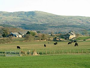
The total land area of Wales is 2,064,100 hectares (5,101,000 acres). In 2013, about 1,712,845 hectares (4,232,530 acres) of this land was used for farming and forestry. Of that, 79,461 hectares (196,350 acres) was for growing crops and fallow land (land left unplanted). 1,449 hectares (3,580 acres) was for growing fruits and vegetables. A large part, 1,405,156 hectares (3,472,220 acres), was used for grazing animals. Forests covered 63,366 hectares (156,580 acres), and 10,126 hectares (25,020 acres) was unclassified land. There were also 180,305 hectares (445,540 acres) of common grazing land. This means the total area used for farming, including common land, was 1,739,863 hectares (4,299,300 acres).
The main crops grown in Wales, by area, were: food for animal feed, spring barley, wheat, maize, winter barley, other cereals, oilseed rape, and potatoes. Most of the grassland was permanent pasture, meaning it's been used for grazing for a long time. Only 10% of the grassland was less than five years old. Compared to other parts of the UK, Wales has the smallest percentage of land used for crops (6%). It also has much less rough grazing and hill land than Scotland (27% compared to 62%).
Wales's Natural Resources
Wales has many natural resources.
Coal and Metals
Huge amounts of coal were mined in Wales during the Industrial Revolution and the early 20th century. After that, coal supplies decreased, and mining became too expensive as cheaper foreign coal became available. The last deep coal mine in Wales closed in 2008.
Ironstone was found along the northern edge of the South Wales Coalfield. It was widely used to produce iron and was very important for starting the Industrial Revolution in South Wales.
Lead, silver, and some zinc were mined for centuries in the upland areas near the rivers Ystwyth and Rheidol, and near the source of the River Severn. Smaller deposits were also mined at Pentre Halkyn during the Roman occupation of Britain. Copper was a major export from Parys Mountain on Anglesey. At its peak, it was the largest copper mine in the world.
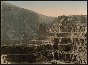
Slate quarrying was a huge industry in North Wales. The Cilgwyn Quarry was being worked in the 12th century. Later, Blaenau Ffestiniog became the main center for slate production.
Water and Wind Power
With its mountainous land and plenty of rain, water is one of Wales's most abundant resources. The country has many man-made reservoirs. Wales exports water to England and also generates electricity using hydroelectric schemes.
Wind is another resource that Wales has a lot of. Gwynt y Môr is one of several offshore wind farms off the coast of North Wales and Anglesey. It is the second largest such wind farm in the world.
People and Culture in Wales
Historians have thought about whether there is one single Welsh identity. For example, in 1921, Alfred Zimmern suggested there were "not one Wales, but three":
- 'Welsh Wales' (the traditional areas)
- 'American Wales' (industrial areas)
- 'English Wales' (upper-class areas)
These represented different parts of the country and different traditions. In 1985, Dennis Balsom suggested a similar 'Three Wales model':
- The Welsh-speaking heartland of the north and west, called Y Fro Gymraeg.
- A 'Welsh Wales' in the South Wales Valleys that felt Welsh but didn't always speak Welsh.
- A more 'British Wales' in the east and along the south coast, which was less strongly Welsh.
These divisions generally match where different political parties get the most support.
North vs. South Wales
The mountains and hills have traditionally made it hard for North and South Wales to connect. Before the Industrial Revolution, the two halves acted almost like separate economic and social areas. Even today, the main roads and railways between South and North Wales often go through England. There used to be a north-south rail link, and some groups are trying to bring it back.
By the years between the World Wars, industries in South Wales were more connected to Bristol and the English Midlands. Industries in North Wales were linked to Merseyside (the area around Liverpool).
Liverpool was sometimes called "the capital of north Wales" in the late 1800s and early 1900s. In 1901, 20,000 Welsh-born people lived near the River Mersey. The city had many Welsh chapels and cultural places. It hosted the National Eisteddfod (a Welsh festival) in 1884, 1900, and 1929. Many important Welsh figures of the 20th century came from Liverpool. The Liverpool Daily Post newspaper became the main daily paper for north Wales. After World War II, Liverpool declined, and Welsh migration patterns changed. This caused the Welsh presence there to shrink. In the 1960s, the flooding of the Tryweryn Valley to provide water for Liverpool made many people in Wales angry.
People from North Wales are sometimes called Gogs (from the Welsh word gogledd, meaning "north"). People from South Wales are sometimes called Hwntws (from tu hwnt, meaning 'far away over there'). There are also differences in Welsh words between the north and south. For example, the South Welsh word for now is nawr, while the North Welsh word is rŵan.
The more urban south, with cities like Cardiff, Newport, and Swansea, was historically home to coal and steel industries. This is different from the mostly rural north, where farming and slate quarrying were the main jobs. Even though the M4 corridor brings wealth to South Wales, especially Cardiff, there isn't a strong economic divide between north and south like in England. For example, there is still a lot of poverty in the former industrial areas of the South Wales Valleys.
Population of Wales
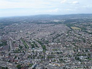
In 2019, the estimated population of Wales was about 3,152,879. This was an increase of 14,248 people from the year before. The main population and industrial areas in Wales are in South Wales. These include Cardiff, Swansea, Newport, and the nearby South Wales Valleys.
Cardiff is the capital city. In the 2011 census, it had a population of about 346,000. Other large areas include Swansea (239,000), Rhondda Cynon Taf (234,400), Carmarthenshire (183,800), Caerphilly (178,800), Flintshire (152,500), Newport (145,700), Neath Port Talbot (139,800), Bridgend (139,200), and Wrexham (134,800). Cardiff was the most crowded area in Wales, with 2,482 people per square kilometer. Powys, in contrast, had only 26 people per square kilometer.
A large number of Welsh people live in smaller towns and villages. Nearly 20% live in villages with fewer than 1,500 people. In England, only 10% live in such small places. Wales also has a relatively small number of people living in very large cities. Only 26% live in urban areas with over 100,000 people. In comparison, nearly 40% of the English population lives in urban areas larger than any in Wales. Another interesting fact is that 15% of the Welsh population lives in very spread-out rural areas, compared to only 1.5% in England.
Travel and Transport in Wales
How people travel within Wales is affected by its mountainous landscape. The main rail and road routes between South and North Wales often curve east and pass mostly through England.
Roads in Wales
The only motorway in Wales is the M4 motorway. It runs from London to South Wales, entering the country over the Second Severn Crossing. It passes near Newport, Cardiff, and Swansea, and goes as far west as Pont Abraham services. From there, it continues northwest as the A48 to Carmarthen. The M48 motorway runs parallel to the M4 between Aust and Magor, passing through Chepstow.
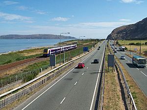
The A40 is a major road connecting London to Fishguard. It goes through Brecon and Carmarthen. The A487 coast road links Cardigan with Aberystwyth. The A44 links Aberystwyth with Rhayader, Leominster, and Worcester. The main road in North Wales is the A55 dual carriageway. It runs from Chester past St Asaph and Abergele, along the coast to Bangor, across Anglesey, and ends at Holyhead. The A483 runs from Swansea to Chester, passing Llandovery, Llandrindod Wells, Oswestry (in England), and Wrexham.
Railways and Airports
The South Wales Main Line connects London Paddington with Swansea. It enters Wales through the Severn Tunnel. Other main train services from the Midlands and North of England join this line at Newport. Branch lines serve the South Wales Valleys, Barry, and places beyond Swansea, including ferry terminals at Fishguard and Pembroke Dock. The Heart of Wales Line connects Llanelli with Craven Arms in Shropshire. The Cambrian Line crosses central Wales, with trains from Shrewsbury to Welshpool, Aberystwyth, and Pwllheli.
The North Wales Coast Line connects Crewe and Chester to Bangor and Holyhead. From Holyhead, there is a ferry service to Ireland. Passengers can change at Shotton for the Borderlands Line, which links Wrexham with Bidston on the Wirral Peninsula. At Conwy, you can change for the Conwy Valley Line to Blaenau Festiniog. The Shrewsbury–Chester line passes through Wrexham, Chirk, and Ruabon in Wales.
Cardiff Airport is the only airport in Wales with regular international flights. You can fly to other parts of the United Kingdom, Ireland, and some parts of Europe. The airport is also used for seasonal charter flights. In 2018, about 1.6 million passengers used the airport. Several ferry services operate between Welsh ports and Ireland: Holyhead to Dublin; Fishguard to Rosslare; Pembroke Dock to Rosslare; and Swansea to Cork.
Protected Natural Areas
Wales has three special areas called national parks.
- Snowdonia National Park in northwestern Wales was created in 1951. It was the third national park in Britain. It covers 827 square miles (2,140 km2) of the Snowdonia mountains and has 37 miles (60 km) of coastline.
- The Pembrokeshire Coast National Park was created the next year. It protects the amazing coastal scenery of West Wales. It includes Caldey Island, the Daugleddau estuary, the Preseli Hills, and the entire Pembrokeshire Coast Path.
- The Brecon Beacons National Park was established five years later. It stretches across southern Powys, northwestern Monmouthshire, parts of eastern Carmarthenshire, and the northern parts of several South Wales Valleys areas.
For each national park, a special local authority manages it. They control building and industrial development in the park. Their job is to protect the natural beauty of the area and help people enjoy and appreciate the park's special qualities.
Wales also has five Areas of Outstanding Natural Beauty (AONBs). These are different from National Parks. Local authorities must protect and improve the natural beauty of these landscapes. However, they don't have to promote public enjoyment. The groups that manage AONBs don't control planning; that responsibility stays with the local councils. In 1956, the Gower Peninsula became the first AONB in Britain. Other AONBs are: the coast of Anglesey; the Llŷn Peninsula; the Clwydian Range and Dee Valley; and the Wye Valley, part of which is in England.
Wales has many waterfalls, including some of the most beautiful in the United Kingdom. One is the 240 ft (73 m) Pistyll Rhaeadr near the village of Llanrhaeadr-ym-Mochnant. It forms as a mountain stream falls over a cliff. This site was named the 1000th Site of Special Scientific Interest in Wales. This is because it helps us understand Welsh geomorphology (how the land is formed). The 19th-century English author George Borrow said of the waterfall, "I never saw water falling so gracefully, so much like thin, beautiful threads, as here."
Images for kids
See also
 In Spanish: Geografía de Gales para niños
 | Lonnie Johnson |
 | Granville Woods |
 | Lewis Howard Latimer |
 | James West |


