Geography of England facts for kids
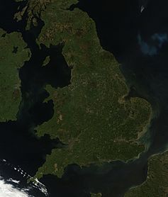
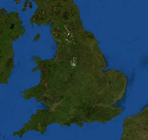
Satellite image including England
|
|
 |
|
| Continent | Europe |
|---|---|
| Region | British Isles |
| Area | |
| • Total | 132,932 km2 (51,325 sq mi) |
| Coastline | 3,200 km (2,000 mi) |
| Borders | |
| Highest point | Scafell Pike 978 m (3,209 ft) |
| Lowest point | Holme Fen, −2.75 m (−9 ft) |
| Longest river | River Severn (shared with Wales) 354 km (220 mi) Longest river entirely within England is the River Thames. 346 km (215 mi) |
| Largest lake | Windermere 14.73 km2 (5.69 sq mi) |
| Climate | Oceanic "British" climate with small areas of Subarctic climate |
| Terrain | Mostly low hills and plains, especially in the south, Midlands and east. Upland or mountainous terrain prevails in the north and parts of the west. |
| Natural resources | Iron, zinc, potash, silica sand, fish, timber, wildlife, petroleum, natural gas, hydropower, wind power, lead, tin, copper, china clay, arable land, and coal |
| Natural hazards | European windstorms, floods, few and small tornadoes |
| Environmental issues | climate change, rising sea levels, renewable energy, waste disposal, water pollution, population density |
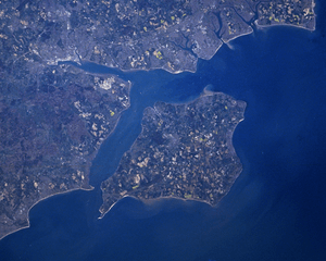
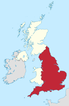
England is a country that makes up most of the central and southern part of the island of Great Britain. It also includes many smaller islands, with the Isle of Wight being the largest. England shares its northern border with Scotland and its western border with Wales. It is very close to mainland Europe, separated from France by only a 33-kilometer (21-mile) sea gap called the English Channel. The 50-kilometer (31-mile) Channel Tunnel, near Folkestone, directly connects England to Europe.
Most of England has low hills and flat plains. However, there are higher, more mountainous areas in the north and west. In the north, you'll find the Pennines, a chain of hills that divides the east and west. The Lake District is also in the north and has the country's highest mountains. Other northern uplands include the Cheviot Hills near the Scottish border and the North York Moors by the North Sea. In the west, there are uplands like Dartmoor and Exmoor in the southwest, and the Shropshire Hills near Wales. The Tees–Exe line often marks the difference between these flatter and hillier areas. South of this line, there are large flat areas like East Anglia and the Fens. But there are also hilly spots like the Cotswolds, the Chilterns, and the North and South Downs.
The biggest natural harbor in England is at Poole, on the south-central coast. Some people believe it's the second largest harbor in the world, after Sydney, Australia, but this is a debated fact.
Contents
England's Climate and Weather
| Weather chart for England 1971–2000 | |||||||||||||||||||||||||||||||||||||||||||||||
|---|---|---|---|---|---|---|---|---|---|---|---|---|---|---|---|---|---|---|---|---|---|---|---|---|---|---|---|---|---|---|---|---|---|---|---|---|---|---|---|---|---|---|---|---|---|---|---|
| J | F | M | A | M | J | J | A | S | O | N | D | ||||||||||||||||||||||||||||||||||||
|
84
7
1
|
60
7
1
|
67
9
2
|
57
12
4
|
56
15
6
|
63
18
9
|
54
21
11
|
67
21
11
|
73
18
9
|
84
14
7
|
84
10
4
|
91
7
2
|
||||||||||||||||||||||||||||||||||||
| temperatures in °C precipitation totals in mm |
|||||||||||||||||||||||||||||||||||||||||||||||
|
Imperial conversion
|
|||||||||||||||||||||||||||||||||||||||||||||||
England has a mild, temperate climate with plenty of rain all year. It's milder than many other places at the same latitude, like Newfoundland in Canada. Temperatures usually stay between -5°C (23°F) and 30°C (86°F). The wind mostly comes from the southwest, bringing mild and wet weather from the Atlantic Ocean.
The east of England is the driest, and the south is the warmest because it's closest to mainland Europe. Snow can fall in winter and early spring, but it's not very common unless you're on high ground. England generally has warmer temperatures and more sunshine throughout the year compared to other parts of the UK. July is usually the sunniest month.
The highest temperature ever recorded in England was 40.3°C (104.5°F) on July 19, 2022, in Coningsby. The lowest was -26.1°C (-15.0°F) on January 10, 1982, in Edgmond, Shropshire. The climate in southwest England is a bit different and even milder, allowing certain crops and flowers to grow earlier.
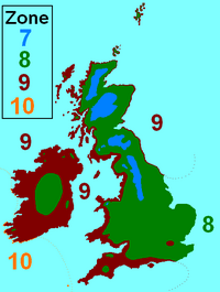
Most of England is in hardiness zone 8, which means it has mild winters. Colder areas like the Pennines are in zone 7. Warmer areas like southwest England, the Irish Sea coast, the South coast, and London are in zone 9. A tiny area, the Isles of Scilly, is in zone 10, which is almost subtropical.
England's Geology
The Geology of England is mostly made of sedimentary rocks. The newest rocks are in the southeast, and as you go northwest, the rocks get older. The Tees–Exe line divides the country into two main geological areas. To the southeast, the rocks are younger, softer, and form low-lying land. To the northwest, the rocks are older, harder, and create higher ground.
England's geology greatly influences the look of its different counties. For example, Cumbria, Kent, and Norfolk all have very unique landscapes because of their underlying rocks. The geology of Northern and Western England is similar to that of Wales and Scotland. Meanwhile, Southern and Eastern England's geology is more like what you find across the North Sea and English Channel in Northern France, Belgium, and the Netherlands.
England has some interesting geological features and resources:
- Geological features
- Cheddar Gorge – the biggest gorge in Great Britain.
- Jurassic Coast – a World Heritage Site known for its fossils.
- Dartmoor – an area with unique rock formations called tors.
- Geological resources
- Coal
- North Sea oil and gas
- Sand and gravel
- China Clay
- Copper and Tin
Major Towns and Cities
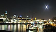
London is by far the largest urban area in England and one of the biggest and busiest cities in the world. Many other cities, especially in central and northern England, are also very large and important. It can be tricky to define the exact size of a city because administrative boundaries don't always match where buildings actually are. Many towns and cities have grown together over time.
Here are the 15 largest urban areas in England based on the 2001 census:
| Rank | Urban area | Population (2001 Census) |
Major localities |
|---|---|---|---|
| 1 | Greater London Urban Area | 8,278,251 | Croydon, Barnet, Ealing |
| 2 | West Midlands Urban Area | 2,284,093 | Birmingham, Wolverhampton, Dudley |
| 3 | Greater Manchester Urban Area | 2,240,230 | Manchester, Salford, Bolton |
| 4 | West Yorkshire Urban Area | 1,499,465 | Leeds, Bradford, Huddersfield |
| 5 | Tyneside | 879,996 | Newcastle upon Tyne, North Shields, South Shields |
| 6 | Liverpool Urban Area | 816,216 | Liverpool, St Helens, Bootle |
| 7 | Nottingham Urban Area | 666,358 | Nottingham, Beeston, Carlton |
| 8 | Sheffield Urban Area | 640,720 | Sheffield, Rotherham, Chapeltown |
| 9 | Bristol Urban Area | 551,066 | Bristol, Kingswood, Mangotsfield |
| 10 | Brighton/Worthing/Littlehampton | 461,181 | Brighton, Worthing, Hove |
| 11 | Portsmouth Urban Area | 442,252 | Portsmouth, Gosport, Waterlooville |
| 12 | Leicester Urban Area | 441,213 | Leicester, Wigston, Oadby |
| 13 | Bournemouth Urban Area | 383,713 | Bournemouth, Poole, Christchurch |
| 14 | Reading/Wokingham Urban Area | 369,804 | Reading, Bracknell, Wokingham |
| 15 | Teesside | 365,323 | Middlesbrough, Stockton-on-Tees, Redcar |
Here are some of the largest cities in England, listed alphabetically:
Physical Geography of England
Extreme Points of England
These are the northernmost, southernmost, westernmost, and easternmost points of England:
| Location | Mainland only | Including islands |
|---|---|---|
|
|
|
Mountains and Hills
England is generally flatter and lower than the rest of the UK. However, it has two main types of land: the lowlands in the south, east, and midlands, and the more rugged, higher areas in the north and west.
East Anglia is the lowest part of England. It has no high hills or mountains. It also contains the Fens, which is the lowest area in England. The highest area is the North West, home to England's tallest hills and mountains, including Scafell Pike. In England, a mountain is officially land over 600 meters (about 1,968 feet). Most of these are in Northern England.
Some of England's hill and mountain ranges include:
- Lake District (Cumbrian Mountains) – These are the highest mountains in England.
- The Pennines – Often called "the backbone of England," they run through much of Northern England.
- The Peak District – The southern part of the Pennines.
- Yorkshire Dales – A beautiful upland area in the northern Pennines.
- North York Moors – Hills and moorlands next to the North Sea.
- Exmoor – Uplands near the Bristol Channel.
- Dartmoor – An upland area in Devon.
- The Cotswolds – A classic English countryside area with rolling hills.
- South Downs – Low hills near the English Channel, famous for the white cliffs.
Cities and Elevation
Cities with higher elevations include Sheffield, Bradford, and Birmingham. Cities close to sea level include London, Liverpool, and York.
Islands of England
Here are some of the main English islands by size and population:
| Rank | Island | Area (sq mi) | Area (km2) |
|---|---|---|---|
| 1 | Isle of Wight | 147.09 | 380.99 |
| 2 | Isle of Sheppey | 36.31 | 94.04 |
| 3 | Hayling Island | 10.36 | 26.84 |
| 4 | Foulness Island | 10.09 | 26.84 |
| 5 | Portsea Island | 9.36 | 24.25 |
Islands by Population
| Rank | Island | Population (2001 UK census) |
|---|---|---|
| 1 | Portsea Island | 147,088 |
| 2 | Isle of Wight | 132,731 |
| 3 | Isle of Sheppey | 37,852 |
| 4 | Canvey Island | 37,473 |
| 5 | Hayling Island | 16,887 |
Rivers of England
The longest river in England is the River Severn. It starts in Wales and flows into England, eventually reaching the Bristol Channel. The longest river that is entirely within England is the River Thames. This river flows through London, the capital city. Many of England's larger rivers are found in the Vale of York and The Fens.
England's Coastline
England has about 4,422 kilometers (2,748 miles) of coastline. This is much less than Scotland's coastline, which has many deep inlets. The English coastline changes a lot depending on the sea it borders.
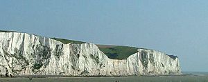
The North Sea coast of England is mostly flat and sandy, with many dunes. It looks similar to the coastlines in the Netherlands. This area is very important for bird life, especially for shore and wading birds. Along the English Channel, the South Coast has tall, white cliffs at Dover. These cliffs are a famous symbol of England and Britain.
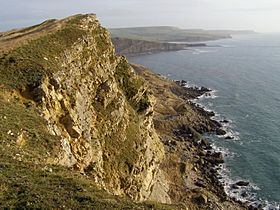
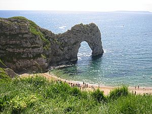
Further along the South Coast, you'll find the Jurassic Coast in Dorset. This coastline is known for its beautiful scenery, rich history, and many fossils.
In Devon and Cornwall, the coastline becomes more rocky and steep, with many cliffs and small fishing villages. This stretch goes all the way to Land's End in Cornwall, which is the westernmost part of mainland England. The coast here looks similar to Brittany in France, which is directly opposite.
Moving north, the coast remains rocky until it reaches the Bristol Channel. This channel is an important area for shipping and docks.
The English coastline appears again in North West England. This part of the coast is mostly flat and sandy, similar to the North Sea coast. The only notable cliffs here are at St Bees Head in Cumbria. The English Irish Sea coast has many estuaries and is important for bird life. Wirral is a peninsula between two rivers, the River Dee and the River Mersey. Liverpool and Merseyside are busy areas with many people and industries along this coast. Further north are tourist towns like Southport and Blackpool. The English Irish Sea coast also includes Morecambe Bay and the Furness and Walney Island areas. The Sellafield Nuclear Power Station is also on this coast. The English section of the Irish Sea coast ends at the border with Scotland in the Solway Firth.
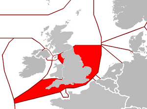
The seas bordering England are:
Largest Lakes and Reservoirs
Even though England is the largest country within the UK, it doesn't have many very large natural lakes. Many of its former wetlands were drained long ago. Most of its biggest lakes are found in the Lake District in Cumbria, Northern England.
| Lake | Area | |
|---|---|---|
| 1 | Windermere | 5.69 sq mi (14.7 km2) |
| 2 | Kielder Reservoir | 3.86 sq mi (10.0 km2) |
| 3 | Ullswater | 3.44 sq mi (8.9 km2) |
| 4 | Bassenthwaite Lake | 2.06 sq mi (5.3 km2) |
| 5 | Derwent Water | 2.06 sq mi (5.3 km2) |
Human Geography of England
Land Use
The total land area of England, not including inland water, is about 130,310 square kilometers (50,313 square miles). About 30% of this land is used for crops and fields. Another 36% is for grasses and grazing animals. Forests and woodlands cover 8% of the land, and urban areas (cities and towns) make up 21%.
Neighbouring Countries
England has two land borders. One is a 96-kilometer (60-mile) border with Scotland, which follows the Cheviot Hills. The other is a 257-kilometer (160-mile) border with Wales, which roughly follows Offa's Dyke.
To the west, the Irish Sea separates England from Ireland and the Isle of Man. To the east, the North Sea separates England from Denmark, Germany, the Netherlands, and Belgium. To the south, the English Channel separates England from France and the Channel Islands.
 |
Iceland | Scotland | Norway |  |
| Wales, Ireland | Netherlands, Germany | |||
| Spain | France | France, Belgium |
England's Economy
England has one of the largest economies in Europe and the world. Its economy is a mixed market economy. This means it uses many free market ideas, but it also has a strong social welfare system to help its citizens. The money used in England is the pound sterling, also known as GBP. England prints its own banknotes, which are also used in Wales. The economy of England is the biggest part of the United Kingdom's economy.
Economic Differences by Region:
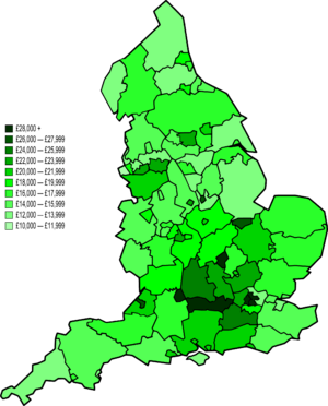
The strength of England's economy varies across its regions. London has the highest GDP (Gross Domestic Product) per person. Generally, the northern and western parts of England are less wealthy, while the southern and eastern areas are richer.
Here's how the GDP per person looked in 2004 for England and its regions:
| Rank | Place | GDP per capita in Euros |
|---|---|---|
| England | 26 904 | |
| 1. | London | 44 401 |
| 2. | South East | 31 300 |
| 3. | East of England | 27 778 |
| 4. | South West | 27 348 |
| 5. | East Midlands | 26 683 |
| 6. | West Midlands | 25 931 |
| 7. | North West | 25 396 |
| 8. | Yorkshire and the Humber | 25 300 |
| 9. | North East | 22 886 |
Two areas in England are among the 10 strongest economies in the European Union. Inner London is number 1, and Berkshire, Buckinghamshire & Oxfordshire is number 7.
See also
 In Spanish: Geografía de Inglaterra para niños
 | Emma Amos |
 | Edward Mitchell Bannister |
 | Larry D. Alexander |
 | Ernie Barnes |


