Geography of Scotland facts for kids
 |
|
 |
|
| Continent | Europe |
|---|---|
| Region | British Isles |
| Area | |
| • Total | 80,231 km2 (30,977 sq mi) |
| • Land | 97% |
| • Water | 3% |
| Coastline | 11,796 km (7,330 mi) |
| Borders | England 154 km (96 mi) |
| Highest point | Ben Nevis 1,346 m (4,416 ft) |
| Lowest point | Atlantic Ocean, 0 m |
| Longest river | River Tay 188 km (117 mi) |
| Largest lake | Loch Lomond 71.3 km2 (27.5 sq mi) |
| Climate | Temperate, Subarctic, Tundra |
| Terrain | mountains, hills, forest, bog, urban |
| Natural resources | iron, zinc, potash, silica sand, coal, fish, timber, wildlife, petroleum, natural gas, hydropower |
| Natural hazards | windstorms, floods |
| Environmental issues | climate change, renewable energy, waste disposal and water pollution |
The geography of Scotland is very diverse. It has everything from quiet lowlands to wild mountains. You'll find big cities and tiny islands with few people.
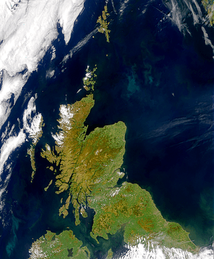
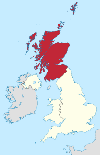
Scotland is in Northern Europe. It's the northern part of Great Britain. It also includes 790 islands. These islands are grouped into the Shetland Islands, Orkney Islands, and the Hebrides.
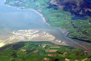
Scotland's only land border is with England. This border is about 96 miles (154 km) long. It stretches from the Solway Firth in the west to the North Sea in the east. Ireland is only 13 nautical miles (24 km) away. This is across the North Channel. Norway is about 190 nautical miles (352 km) to the northeast. The Atlantic Ocean touches Scotland's western and northern coasts. This ocean greatly affects Scotland's mild, temperate climate.
Scotland has most of the mountains in the UK. A special line called the Highland Boundary Fault divides the country. It runs from Helensburgh to Stonehaven. This fault separates the rugged Highlands in the north and west. It also separates the flatter Lowlands in the south and east. The Highlands have Scotland's highest peak, Ben Nevis.
The Lowlands are flatter and have most of the people. Many live in the Central Belt. This is a narrow area between the Firth of Clyde and the Firth of Forth. Glasgow is Scotland's biggest city. Edinburgh is the capital and political center. Even in the Lowlands, you can find hills. These are in the Southern Uplands.
Scotland has many natural resources. Things like coal, iron, and zinc helped its industries grow. Today, energy is a big part of Scotland's economy. Scotland produces a lot of oil. But renewable energy is becoming very important. It helps both the economy and the environment.
Contents
How Scotland's Land Was Formed
Scotland covers about 30,090 square miles (77,933 km²). This is 32% of the total area of the United Kingdom. The mainland has a coastline of about 6,160 miles (9,914 km).
Scotland's shape was created by tectonic plates moving. Then, glaciation (ice ages) carved out the land. The main split in Scotland is the Highland Boundary Fault. This fault divides the country into 'highland' (north and west) and 'lowland' (south and east). The Highlands are mostly mountains. They are the highest land in the UK. The Great Glen splits them into the Grampian Mountains and the Northwest Highlands.
The Scottish Lowlands have two parts. The Southern Uplands have rolling farmland and high moorland. The Central Belt and eastern Scotland have lowland farmland. Scotland has many different types of rocks for its size.
The oldest rocks in Scotland are the Lewisian gneisses. They formed about 3 billion years ago. These are some of the oldest rocks on Earth. Other old rocks like the Torridonian sandstones also formed long ago.
Millions of years ago, the land that became Scotland was near the South Pole. Two huge landmasses, Laurentia and Baltica, slowly crashed together. This event is called the Caledonian Orogeny. The Highland Boundary Fault shows where these landmasses joined. The Southern Uplands were pushed up from the seabed during this crash. The Highlands also rose, possibly as high as the Alps are today.
Later, Scotland was near the equator. Sea levels changed many times. This created the coal deposits in Lanarkshire. Volcanoes were active across Scotland. Arthur's Seat in Edinburgh is an old volcano. By the time of the dinosaurs, Scotland was a desert. This formed large sandstone areas in the southwest.
Much later, the tectonic plates moved again. This created the Atlantic Ocean, separating North America from Europe. This split happened west of Scotland. It left a chain of old volcanoes through the Hebrides, like on Skye. This was the last time new rocks formed in Scotland.
Scotland's Physical Features
Main Points of the Mainland
Here are the extreme points of mainland Scotland:
- North: Easter Head, Dunnet Head, Caithness
- East: Keith Inch, Peterhead, Aberdeenshire
- South: Mull of Galloway, Dumfries and Galloway
- West: Corrachadh Mòr, Ardnamurchan (a headland), Lochaber
Many people think John o' Groats is the most northerly point. But it's not quite.
Extreme Points Including Islands
The very edges of Scotland, including its islands, are:
- North: Out Stack, north of Unst, Shetland Islands
- East: Bound Skerry, Out Skerries, Shetland Islands
- South: Mull of Galloway, Dumfries and Galloway
- West: Either Rockall (its status is debated) or Soay, St. Kilda, Western Isles.
The true geographical center of Scotland is near Newtonmore. The center of the mainland is near Schiehallion.
How Land is Used
Scotland's total land area is about 8 million hectares. Most of it (67%) is used for grasses and grazing animals. Forests and woodlands cover 17% of the land. Cities and towns take up 8%. Crops are grown on 7% of the land. Other farming land is 2%.
Mountains and Hills
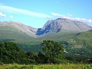
Scotland has the most mountains in Great Britain. Most of the highest mountains are in the Northwest Highlands and Grampian ranges. These are north and west of the Highland Boundary Fault. The jagged Cuillin mountains are on the Isle of Skye.
Ben Nevis is the highest mountain in Scotland and Great Britain. It's 1,345 meters (4,413 ft) tall. It's at the western end of the Grampian Mountains. Ben Macdui and Braeriach are the second and third tallest. They are in the Cairngorms, which is the highest mountain area in Britain.
In southern Scotland, you'll find the Southern Uplands. These are rolling hills, less rugged than the Highlands. They have more forests. The tallest mountain here is Merrick, at 843 meters (2,766 ft). Even in the central lowlands, there are hills. Examples include the Ochil Hills near Stirling and the Campsie Fells near Glasgow.
Mountains in Scotland are grouped by their height. Peaks over 3,000 feet (914 m) are called Munros. There are 282 Munros, all in the Highlands. Peaks between 2,500 and 3,000 feet (762 and 914 m) are called Corbetts. These must rise at least 500 feet (152 m) above the land around them.
Coastline and Sea Inlets
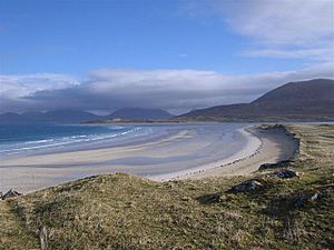
Mainland Scotland has about 6,160 miles (9,914 km) of coastline. If you include all the islands, it's about 11,602 miles (18,672 km). The west coast is very jagged. It has long peninsulas and fjord-like sea lochs. The east coast is smoother. It has large inlets called firths and long sandy beaches.
Some parts of the coast have a special type of land called machair. This is a grassy area formed by sand dunes as sea levels dropped. The east coast has important estuaries (river mouths). These include the Ythan Estuary and Fowlsheugh. They are important places for birds.
Firths on the west coast include the Solway Firth and Firth of Clyde. On the east coast, there's the Moray Firth and Firth of Forth. The Pentland Firth is a strait (narrow waterway). It separates the Orkney Isles from the mainland.
Major sea lochs include Loch Fyne, Loch Long, and Loch Linnhe.
Islands of Scotland
Scotland has over 900 islands. More than 100 of them have people living on them. Most islands are off the northern and western coasts. The main island groups are Shetland, Orkney, and the Hebrides. The Hebrides are split into the Inner Hebrides and Outer Hebrides. Shetland and Orkney are also called the Northern Isles.
Lewis and Harris is the largest Scottish island. It covers 860 square miles (2,227 km²). Many islands have strong tides. The Corryvreckan tide race is one of the world's largest whirlpools. It's between Scarba and Jura.
There are also many islands in the Firth of Forth and Firth of Clyde. Some islands are in freshwater lochs, like Loch Lomond. Far-off islands include St Kilda and Rockall.
Scotland's islands have different landscapes. Mull and Skye are known for their mountains. But Tiree and Coll are flat. Even within the same group, islands can be very different. For example, Hoy in Orkney is hilly. But the other Orkney islands are flatter.
Rivers of Scotland
Here are Scotland's ten longest rivers:
- 1. River Tay (120 miles / 193 km)
- 2. River Spey (107 miles / 172 km)
- 3. River Clyde (106 miles / 171 km)
- 4. River Tweed (97 miles / 156 km)
- 5. River Dee (85 miles / 137 km)
- 6. River Don (82 miles / 132 km)
- 7. River Forth (65 miles / 105 km)
- 8. River Findhorn (63 miles / 101 km)
- 9. River Deveron (61 miles / 98 km)
- 10. River Annan (50 miles / 80 km)
A long line called the watershed separates rivers. Rivers on one side flow west to the Atlantic Ocean. Rivers on the other side flow east into the North Sea. This watershed is 745 miles (1,199 km) long.
Lochs (Lakes) of Scotland
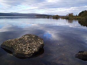
Most freshwater bodies in Scotland are called lochs. Only the Lake of Menteith and a few man-made "lakes" are different. Scotland holds 90% of Great Britain's standing freshwater.
Loch Lomond is the largest freshwater body in Britain by area. But Loch Ness holds the most water. It has nearly twice the water of all the lakes in England and Wales combined. It's the largest lake by volume in the UK and Ireland.
Here are the ten largest lochs by area:
- 1. Loch Lomond (27.5 sq mi / 71.3 km²)
- 2. Loch Ness (22.0 sq mi / 57.0 km²)
- 3. Loch Awe (15.0 sq mi / 38.8 km²)
- 4. Loch Maree (11.0 sq mi / 28.5 km²)
- 5. Loch Morar (10.3 sq mi / 26.7 km²)
- 6. Loch Tay (10.2 sq mi / 26.4 km²)
- 7. Loch Shin (8.7 sq mi / 22.5 km²)
- 8. Loch Shiel (7.6 sq mi / 19.7 km²)
- 9. Loch Rannoch (7.4 sq mi / 19.2 km²)
- 10. Loch Ericht (7.2 sq mi / 18.6 km²)
Distances to Other Countries
Scotland's only land border is with England. It's about 60 miles (97 km) long. The Atlantic Ocean is to the west. The North Sea is to the east.
Ireland is only 12 nautical miles (22 km) from the Kintyre peninsula. Norway is 190 nautical miles (352 km) to the east. The Faroes are 170 nautical miles (315 km) north. Iceland is 460 nautical miles (852 km) to the northwest.
Scotland's Climate
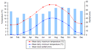
Scotland's climate is mild and changes a lot. But it's rarely extreme. The North Atlantic Drift warms Scotland. This means it's much milder than other places at the same northern latitude. For example, Labrador in Canada has icebergs in winter.
Average temperatures in Scotland are lower than in the rest of Great Britain. The coldest UK temperature ever was -27.2°C (-17.0°F). This was recorded in Braemar in 1982 and Altnaharra in 1995. Winter highs are usually 5.0 to 5.7°C (41.0 to 42.3°F). Summer highs are 14.9 to 16.9°C (58.8 to 62.4°F).
Western coastal areas are warmer than the east. This is because of the Atlantic currents. The North Sea makes the east colder. But on rare hot days, the west is cooler than the east. The highest temperature ever was 32.9°C (91.2°F) in Greycrook in 2003. Some places like Inverewe Garden are warm enough for palm trees.
Rainfall varies a lot. The western Highlands are one of the wettest places in the UK. They get up to 4,577 mm (180.2 in) of rain each year. This rain happens when warm, wet air from the Atlantic hits the mountains. The air rises, cools, and forms clouds.
Much of eastern Scotland gets less than 870 mm (34.3 in) of rain yearly. This is because it's in the rain shadow of the western mountains. Dunbar, east of Edinburgh, gets only 560.18 mm (22.05 in) of rain. That's less than Barcelona!
Snow is less common in low areas. But it's more common in the mountains. Parts of the Highlands have 36 to 60 snow days a year. Some western coastal areas have only 0 to 6 snow days. The Cairngorms mountains are Scotland's snowiest spot.
The island of Tiree had 329 hours of sunshine in May 1946 and May 1975. This is the most sunshine recorded in one month in Scotland. On the longest day of the year, the northern islands don't get completely dark. Lerwick in Shetland has four more hours of daylight than London in midsummer. But this is reversed in midwinter.
Winds usually come from the southwest. They bring warm, wet air from the Atlantic. The windiest parts of Scotland are in the north and west. The Outer Hebrides, Orkney, and Shetland have over 30 days with strong winds (gales) each year. Strong Atlantic storms are common in autumn and winter.
People and Places in Scotland
In June 2008, Scotland's population was 5,168,500. This was a 2.1% increase since 2001. Scotland's share of the UK population has been shrinking. But more births and people moving to Scotland have helped it grow recently.
Scotland has a low population density compared to Europe. There are about 65 people per square kilometer. However, Scotland is very urbanised. About 82% of people live in towns or cities with 3,000 or more residents. Most people live in the Central Belt. This area surrounds the main cities of Glasgow and Edinburgh.
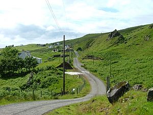
Other groups of people live on the northeast coast, near Aberdeen. Also, around Inverness. The Highlands are the most sparsely populated part of Scotland. They have only 8 people per square kilometer. In these areas, people live in small villages, towns, or isolated farms called crofts.

Almost 100 of Scotland's islands have people living on them. Lewis and Harris is the most populated island. It had 21,031 people in 2011. Most live around Stornoway. The number of people living on Scotland's islands dropped by 3% between 1991 and 2001. But some islands like Tiree and Skye saw their populations grow.
Scotland has eight cities: Glasgow, Edinburgh, Aberdeen, Dundee, Inverness, Perth, Dunfermline, and Stirling. In 2001, Glasgow was the largest city with 629,501 people. Edinburgh, the capital, had 448,624 people. Between 1991 and 2001, Edinburgh and Stirling grew. Inverness grew by over 10%. But Glasgow, Dundee, and Aberdeen saw their populations shrink.
Scotland's Economy
Scotland's total economic output (GDP) was about £211.7 billion (US$290 billion) in 2023. This includes oil and gas from Scottish waters. This means about £38,622 per person.
Major industries in Scotland include banking and financial services. Also, making steel and transport equipment. Other important industries are oil and gas, farming, making whisky, and tourism.
See also
 In Spanish: Geografía de Escocia para niños
 | Audre Lorde |
 | John Berry Meachum |
 | Ferdinand Lee Barnett |


