Hillsborough County, New Hampshire facts for kids
Quick facts for kids
Hillsborough County
|
||
|---|---|---|

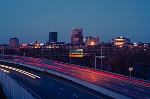
Manchester skyline
|
||
|
||

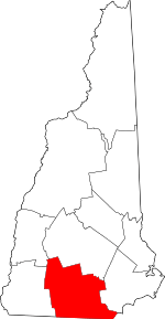
Location within the U.S. state of New Hampshire
|
||
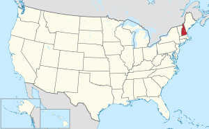
 New Hampshire's location within the U.S. |
||
| Country | ||
| State | ||
| Founded | 1769 | |
| Named for | The Earl of Hillsborough | |
| Seat | Manchester and Nashua | |
| Largest city | Manchester (by population) Weare (by area) |
|
| Area | ||
| • Total | 892.5 sq mi (2,312 km2) | |
| • Land | 876.5 sq mi (2,270 km2) | |
| • Water | 15.9 sq mi (41 km2) 1.8% | |
| Population
(2020)
|
||
| • Total | 422,937 | |
| • Estimate
(2022)
|
426,594 |
|
| • Density | 486.7/sq mi (187.9/km2) | |
| Time zone | UTC−5 (Eastern) | |
| • Summer (DST) | UTC−4 (EDT) | |
| Congressional districts | 1st, 2nd | |
Hillsborough County is the county with the most people in the state of New Hampshire. In 2020, about 422,937 people lived here. This is almost one-third of everyone in New Hampshire!
The county seats, or main administrative cities, are Manchester and Nashua. These are also the two largest cities in the state. Hillsborough County is the most populated and most crowded county in northern New England.
This county is part of a larger area called the Manchester-Nashua Metropolitan Statistical Area. This area is also a piece of an even bigger region that includes Boston, Worcester, and Providence.
Contents
History of Hillsborough County
Hillsborough was one of the first five counties created for the old Province of New Hampshire. This happened in 1769. The county was named after Wills Hill, who was the Earl of Hillsborough. He was a British government official in charge of the colonies at that time. The county officially started on March 19, 1771, in Amherst.
Later, in 1823, twelve towns from Hillsborough County became part of a new county called Merrimack County. The town of Merrimack itself, which is in Hillsborough County, was not included in the new county.
The county's main offices moved a few times. First, they moved from Amherst to Milford in 1866. Then, in 1869, they moved to the current county seats, Manchester and Nashua.
Geography of Hillsborough County
Hillsborough County covers a total area of about 892 square miles. Most of this area, about 876 square miles, is land. The remaining 16 square miles (1.8%) is water.
The highest point in Hillsborough County is Pack Monadnock Mountain. It stands tall at 2,290 feet.
Neighboring Counties
Hillsborough County shares its borders with several other counties:
- Merrimack County (to the north)
- Rockingham County (to the east)
- Essex County, Massachusetts (to the southeast)
- Middlesex County, Massachusetts (to the south)
- Worcester County, Massachusetts (to the southwest)
- Cheshire County (to the west)
- Sullivan County (to the northwest)
Protected Natural Areas
- Wapack National Wildlife Refuge
Population and People
| Historical population | |||
|---|---|---|---|
| Census | Pop. | %± | |
| 1790 | 32,883 | — | |
| 1800 | 43,899 | 33.5% | |
| 1810 | 49,249 | 12.2% | |
| 1820 | 53,884 | 9.4% | |
| 1830 | 37,724 | −30.0% | |
| 1840 | 42,494 | 12.6% | |
| 1850 | 57,478 | 35.3% | |
| 1860 | 62,140 | 8.1% | |
| 1870 | 64,238 | 3.4% | |
| 1880 | 75,634 | 17.7% | |
| 1890 | 93,247 | 23.3% | |
| 1900 | 112,640 | 20.8% | |
| 1910 | 126,072 | 11.9% | |
| 1920 | 135,512 | 7.5% | |
| 1930 | 140,165 | 3.4% | |
| 1940 | 144,888 | 3.4% | |
| 1950 | 156,987 | 8.4% | |
| 1960 | 178,161 | 13.5% | |
| 1970 | 223,941 | 25.7% | |
| 1980 | 276,608 | 23.5% | |
| 1990 | 336,073 | 21.5% | |
| 2000 | 380,841 | 13.3% | |
| 2010 | 400,721 | 5.2% | |
| 2020 | 422,937 | 5.5% | |
| 2022 (est.) | 426,594 | 6.5% | |
| U.S. Decennial Census 1790–1960 1900–1990 1990–2000 2010–2020 |
|||
2020 Census Information
In 2020, the county had 422,937 people. This means there were about 482 people living in each square mile.
The people living in Hillsborough County come from many different backgrounds. Based on the 2020 census:
- About 81% of the people were white.
- Around 4.8% were Asian.
- About 3.9% were Black or African American.
- Around 1.7% were American Indian.
- About 2.1% were from other races.
- About 2.0% were from two or more races.
- People of Hispanic or Latino origin made up 8% of the population.
Many people in the county have French ancestry (about 24.8%). This includes those with French Canadian roots. Other common ancestries include Irish (20.9%), English (13.1%), Italian (10.2%), and German (8.2%).
Cities and Towns
Hillsborough County has several cities and many towns.
Cities
- Manchester (a county seat)
- Nashua (a county seat)
Towns
Census-Designated Places
These are areas that are like towns but are not officially incorporated as towns.
- Amherst
- Antrim
- Bennington
- East Merrimack
- Francestown
- Goffstown
- Greenville
- Hancock
- Hillsborough
- Hudson
- Klondike Corner
- Milford
- New Boston
- Peterborough
- Pinardville
- Wilton
Villages
Former Towns
- Monson
Education in Hillsborough County
Many different school districts serve the students in Hillsborough County.
K-12 School Districts
These districts offer schooling from kindergarten through 12th grade.
- Bedford School District
- Contoocook Valley School District
- Goffstown School District
- Hillsboro-Deering Cooperative School District
- Hudson School District
- Litchfield School District
- Manchester School District
- Mascenic Regional School District
- Merrimack School District
- Milford School District
- Nashua School District
- Pelham School District
- Wilton-Lyndeborough School District
- Windsor School District
Secondary School Districts
These districts focus on high school education.
- Hollis-Brookline Cooperative School District
- Souhegan Cooperative School District
- John Stark Regional School District
Elementary School Districts
These districts provide education for younger students, typically up to middle school.
- Amherst School District
- Brookline School District
- Hollis School District
- Mason School District
- Mont Vernon School District
- New Boston School District
- Weare School District
See also
 In Spanish: Condado de Hillsborough (Nuevo Hampshire) para niños
 | DeHart Hubbard |
 | Wilma Rudolph |
 | Jesse Owens |
 | Jackie Joyner-Kersee |
 | Major Taylor |


