
Oxfordshire facts for kids
Quick facts for kids
Oxfordshire
|
|||||||||||||||||||||||||||||||||||||||||||||||||||||
|---|---|---|---|---|---|---|---|---|---|---|---|---|---|---|---|---|---|---|---|---|---|---|---|---|---|---|---|---|---|---|---|---|---|---|---|---|---|---|---|---|---|---|---|---|---|---|---|---|---|---|---|---|---|
|
Clockwise from top left: the Radcliffe Camera, part of the University of Oxford; Islip, in the Cherwell district; and the Uffington White Horse
|
|||||||||||||||||||||||||||||||||||||||||||||||||||||
 Ceremonial Oxfordshire within England Ceremonial Oxfordshire  Historic Oxfordshire in the British Isles Historic Oxfordshire |
|||||||||||||||||||||||||||||||||||||||||||||||||||||
| Sovereign state | United Kingdom | ||||||||||||||||||||||||||||||||||||||||||||||||||||
| Constituent country | England | ||||||||||||||||||||||||||||||||||||||||||||||||||||
| Region | South East England | ||||||||||||||||||||||||||||||||||||||||||||||||||||
| Time zone | UTC±00:00 (Greenwich Mean Time) | ||||||||||||||||||||||||||||||||||||||||||||||||||||
| • Summer (DST) | UTC+01:00 (British Summer Time) | ||||||||||||||||||||||||||||||||||||||||||||||||||||
| Members of Parliament | 7 Members of Parliament | ||||||||||||||||||||||||||||||||||||||||||||||||||||
| Police | Thames Valley Police | ||||||||||||||||||||||||||||||||||||||||||||||||||||
| Largest city | Oxford | ||||||||||||||||||||||||||||||||||||||||||||||||||||
|
|||||||||||||||||||||||||||||||||||||||||||||||||||||

.jpg)


Oxfordshire is a county in South East England. It is often called Oxon for short. The county shares borders with Northamptonshire and Warwickshire to the north. To the east, it borders Buckinghamshire. In the south, you'll find Berkshire, and to the west are Wiltshire and Gloucestershire.
The biggest city and main town in Oxfordshire is Oxford. The county is mostly countryside. It covers an area of about 2,605 square kilometers (1,006 square miles). Around 691,667 people live here. After Oxford, the largest towns are Banbury and Abingdon-on-Thames.
Oxfordshire has five local government areas. Part of the county south of the River Thames used to be part of Berkshire. This area is now mostly the Vale of White Horse district.
The middle of the county has lowlands with the River Thames and its smaller rivers. Low hills separate these river valleys. In the south, you can find parts of the Berkshire Downs and Chiltern Hills. The north-west includes part of the Cotswolds. These three areas are known for their beautiful natural scenery. The highest point in Oxfordshire is White Horse Hill, which is 261 meters (856 feet) tall.
Contents
History of Oxfordshire
Oxfordshire became a county in the early 900s. It is located between the River Thames to the south and the Cotswolds to the west. The Chilterns are to the east, and the Midlands are to the north.
The area was important for farming in the past. However, it did not become very important until the town of Oxford was formed in the 700s. Alfred the Great, a famous English king, was born nearby in Wantage. The University of Oxford was started in 1096. It became very important during the Middle Ages.
From the 1200s, the county was part of the Cotswolds wool trade. This brought a lot of wealth, especially to the western parts of Oxfordshire. Later, in 1912, Morris Motors began in Oxford. This brought heavy industry to the county, which was mostly farming before. Today, very few people work in farming because machines do most of the work. Still, Oxfordshire remains a very agricultural county by land use.
Historically, the county was divided into fourteen areas called "hundreds." These included places like Bampton, Banbury, and Wootton.
In 1974, some towns that were once part of Berkshire joined Oxfordshire. These included Abingdon-on-Thames, Didcot, Faringdon, Wallingford, and Wantage. However, some areas like Caversham and Stokenchurch moved to other counties.

Geography of Oxfordshire
Oxfordshire has parts of three special areas known for their natural beauty. These are the Cotswolds in the north-west, and the North Wessex Downs and Chilterns in the south and south-east. The north of the county has ironstone hills.
You can enjoy long walks on trails like the Ridgeway National Trail and the Oxfordshire Way.
What are the Extreme Points of Oxfordshire?
- The northernmost point is near Claydon Hay Farm, Claydon.
- The southernmost point is near Thames and Kennet Marina, Playhatch.
- The westernmost point is near Downs Farm, Westwell.
- The easternmost point is on the River Thames, near Lower Shiplake.
Rivers and Canals in Oxfordshire
The River Thames flows through Oxfordshire from west to south-east. It passes through the city of Oxford. This river used to mark the border with Berkshire. The Thames Path is a walking trail that follows the river.
Many smaller rivers flow into the Thames in Oxfordshire. These include the Thame, Windrush, Evenlode, and Cherwell. Some of these rivers also have walking trails along their valleys.
The Oxford Canal connects Oxfordshire to the Midlands. It follows the River Cherwell from Banbury to Oxford. Here, it joins the Thames. Parts of the Wilts & Berks Canal are also being restored.
What is the Green Belt?
Oxfordshire has a special "green belt" area. This area completely surrounds the city of Oxford. It helps protect nearby towns and villages from too much building and city growth. The green belt was first set up in the 1950s. All of Oxfordshire's districts have some part of this protected land.
Economy of Oxfordshire
Oxfordshire's economy has grown over the years. Here's a look at how much money the county made in different areas:
| Year | Total Value | Agriculture | Industry | Services |
|---|---|---|---|---|
| 1995 | 7,607 | 120 | 2,084 | 5,404 |
| 2000 | 10,594 | 80 | 2,661 | 7,853 |
| 2003 | 12,942 | 93 | 2,665 | 10,184 |
The "Services" sector, which includes things like education, healthcare, and tourism, makes up the largest part of the economy.
Education in Oxfordshire
Oxfordshire has many schools, both independent (private) and state-funded. There are 23 independent schools and 35 state secondary schools. Most schools have a sixth form, where students can study after age 16.
The county is home to two universities in Oxford. The University of Oxford is very old and famous. Oxford Brookes University is a more modern university. There is also Wroxton College in Banbury, which is linked to a university in New Jersey, USA.


Famous Buildings in Oxfordshire
Oxford is known for its beautiful university buildings, often called "dreaming spires." It is one of the most visited cities in the UK by people from other countries.
Notable University Buildings
- The Sheldonian Theatre was built between 1664 and 1668. It was designed by the famous architect Sir Christopher Wren.
- The Radcliffe Camera was built between 1737 and 1749. It was designed by James Gibbs.
Historic Country Houses
- Blenheim Palace is near Woodstock. It was designed for John Churchill, 1st Duke of Marlborough. He won a big battle called the Battle of Blenheim. The gardens were designed by "Capability" Brown. He even planted trees to look like the winning army's battle formation! Winston Churchill, a famous Prime Minister, was born here in 1874. You can visit the palace and gardens.
- Chastleton House is a large country mansion. It was built on land bought from Robert Catesby, who was involved in the Gunpowder Plot.
- Stonor Park is another old country mansion. It has belonged to the Stonor family for many centuries.
- Mapledurham House is an Elizabethan stately home in the south-east of the county.
- The Abbey in Sutton Courtenay is a medieval house. It is considered a great example of an English medieval manor house.

Towns and Villages in Oxfordshire
Oxfordshire has many towns and villages. Here are some of the largest:


| Rank | Town | Population | Year | Notes |
|---|---|---|---|---|
| 1 | Oxford | 162,100 | 2021 | The main city in Oxfordshire. |
| 2 | Banbury | 54,335 | 2021 | |
| 3 | Abingdon-on-Thames | 37,931 | 2021 | Was in Berkshire until 1974. |
| 4 | Bicester | 37,020 | 2021 | |
| 5 | Didcot | 32,183 | 2021 | Was in Berkshire until 1974. |
| 6 | Witney | 31,217 | 2021 | |
| 7 | Carterton | 15,680 | 2021 | |
| 8 | Kidlington | 13,600 | 2021 | |
| 9 | Thame | 13,273 | 2021 | |
| 10 | Wantage | 13,106 | 2021 | Was in Berkshire until 1974. |
| 11 | Henley-on-Thames | 12,186 | 2021 | |
| 12 | Faringdon | 8,627 | 2021 | Was in Berkshire until 1974. |
| 13 | Wallingford | 8,455 | 2021 | Was in Berkshire until 1974. |
| 14 | Grove | 8,336 | 2021 | |
| 15 | Chinnor | 7,651 | 2021 | |
| 16 | Chipping Norton | 7,250 | 2021 | |
| 17 | Eynsham | 5,324 | 2021 | |
| 18 | Benson | 4,801 | 2021 | |
| 19 | Wheatley | 4,267 | 2021 | |
| 20 | Sonning Common | 4,138 | 2021 | |
| 21 | Kennington | 4,133 | 2021 | |
| 22 | Woodstock | 3,521 | 2021 | |
| 23 | Charlbury | 3,063 | 2021 | |
| 24 | Bampton | 2,993 | 2021 | |
| 25 | Watlington | 2,697 | 2021 | |
| 26 | Deddington | 2,301 | 2021 |
Fun Places to Visit in Oxfordshire
Oxfordshire has many interesting places to explore, from museums to historic houses and beautiful natural areas.
| Key | |
| Owned by the National Trust | |
| Owned by English Heritage | |
| Owned by the Forestry Commission | |
| A Country Park | |
| An Accessible open space | |
| Museum (free) | |
| Museum (charges entry fee) | |
| Heritage railway | |
| Historic House | |
 Abingdon County Hall Museum – A museum in a 17th-century building.
 Ashdown House – A 17th-century country house in the North Wessex Downs.
- Ashmolean Museum – Oxford University's museum of art and old objects.
- Banbury Museum, Banbury.
- Bicester Village – A popular shopping destination.
 Blenheim Palace and garden – A UNESCO World Heritage Site (very important place).
- Broughton Castle – A strong 14th-century manor house.
- Buscot Park, Buscot – An 18th-century country house with a lovely garden.
- Champs Chapel Museum of East Hendred – A village museum in a 15th-century chapel.
- Charlbury Museum.
- Chastleton House – A 17th-century country house (check for visiting times).
 Chiltern Hills – A beautiful natural area.
 Chinnor & Princes Risborough Railway – You can ride on old steam and diesel trains here.
 Chipping Norton Museum.
- Cholsey and Wallingford Railway.
- Cogges Manor Farm Museum, Witney – A museum that shows what country life was like.
- Combe Mill Museum, Long Hanborough – See old steam engines working.
 Cotswold Wildlife Park and garden, Bradwell Grove, Holwell – A great place to see animals.
- Cotswolds – Another beautiful natural area.
- Didcot Railway Centre – A museum about the Great Western Railway.
 Dorchester Abbey, Dorchester-on-Thames – A 12th-century church.
- Great Coxwell Barn – A large 14th-century barn.
- Greys Court, Rotherfield Greys – A 16th-century country house.
- Hampton Gay Manor – The ruins of a 16th-century manor house.
- Harcourt Arboretum, Nuneham Courtenay – A place with many different trees.
- Heythrop Hall – A 17th-century country house, now a hotel.
- Hook Norton Brewery – A working Victorian brewery that offers tours.
- Kelmscott Manor – The home of the famous artist William Morris.
- Mapledurham Estate – A 16th-century country house and a 15th-century watermill.
- Milton Manor House – An 18th-century country house.
 Minster Lovell Hall – Ruins of a 15th-century manor house.
- Museum of Bygones, Claydon – A private museum with old steam engines.
- North Wessex Downs – A beautiful natural area.
-
 Oxford – The famous city with many attractions.
 - Oxford Bus Museum and Morris Motors Museum, Long Hanborough.
- Oxford Canal – An 18th-century canal.
- The Oxfordshire Museum, Woodstock.
- The Ridgeway – An ancient walking trail.
- River and Rowing Museum, Henley-on-Thames.
- River Thames – England's most famous river.
- Rollright Stones – Ancient stone circles and burial chambers.
- Rousham House – A 17th-century country house with a beautiful garden.
- Rycote chapel – A 15th-century chapel with its original furniture.
- St Katharine's church, Chiselhampton – An 18th-century church with original furnishings.
- St Mary's church, Iffley – A 12th-century Norman church.
 Shotover Country Park, Headington – A park for outdoor activities.
- Spiceball Country Park, Banbury.
- Stanton Harcourt manor house – A manor house with a garden and a 15th-century chapel.
- Stonor Park – A country house with a 14th-century chapel.
- Swalcliffe Tithe Barn – A 15th-century barn.
- Thame Museum.
- Tolsey Museum, Burford.
- Uffington White Horse, Uffington Castle and Wayland's Smithy burial chamber in the White Horse Hills – Ancient landmarks.
- Vale and Downland Museum, Wantage.
- Wallingford Museum.
- Wheatley Windmill – An 18th-century windmill.
Images for kids
-
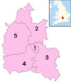
The five districts of Oxfordshire.
See also
 In Spanish: Oxfordshire para niños
