Rockingham County, New Hampshire facts for kids
Quick facts for kids
Rockingham County
|
|||
|---|---|---|---|
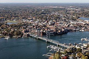
Aerial view of Portsmouth
|
|||
|
|||
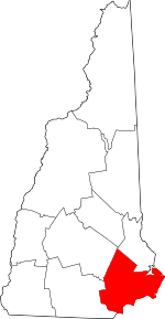
Location within the U.S. state of New Hampshire
|
|||
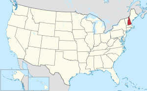 New Hampshire's location within the U.S. |
|||
| Country | |||
| State | |||
| Founded | 1769 | ||
| Named for | Charles Watson-Wentworth, 2nd Marquess of Rockingham | ||
| Seat | Brentwood | ||
| Largest town | Derry | ||
| Area | |||
| • Total | 795.2 sq mi (2,060 km2) | ||
| • Land | 695.4 sq mi (1,801 km2) | ||
| • Water | 99.9 sq mi (259 km2) 12.6% | ||
| Population
(2020)
|
|||
| • Total | 314,176 | ||
| • Estimate
(2022)
|
319,424 |
||
| • Density | 395.091/sq mi (152.545/km2) | ||
| Time zone | UTC−5 (Eastern) | ||
| • Summer (DST) | UTC−4 (EDT) | ||
| Congressional districts | 1st, 2nd | ||
Rockingham County is a county in the state of New Hampshire. In 2020, about 314,176 people lived here. This makes it New Hampshire's second-biggest county by population.
The main office, or county seat, is in Brentwood. Rockingham County is part of the larger Boston area. It was the fastest-growing county in New Hampshire between 2010 and 2020. It is also one of the wealthiest counties in New England.
Contents
History of Rockingham County
The first Europeans came to this area around 1623. They moved north from the Plymouth Colony in Massachusetts. New Hampshire became its own colony in 1679. But counties were not created until 1769.
Rockingham was one of the first five counties in the colony. It was named after Charles Watson-Wentworth, 2nd Marquess of Rockingham. He was the Prime Minister of the UK from 1765 to 1766. The county officially started in 1771. Its first county seat was Exeter.
Over time, parts of Rockingham County were used to create new counties. In 1823, some areas became part of Merrimack County. In 1844, more land was used to form Belknap County. In 1997, the county court offices moved to Brentwood. This town is close to Exeter.
Geography of Rockingham County
Rockingham County is in the southeast corner of New Hampshire. It has the state's easternmost point. The county also has all of New Hampshire's Atlantic coast. This coastline is about 18 miles long. It is the shortest ocean coastline of any state in the U.S.
The county covers about 795 square miles. About 695 square miles are land. The other 100 square miles are water. The highest point in the county is Nottingham Mountain. It is about 1,340 feet tall. You can find it in Deerfield.
Neighboring Counties
Rockingham County shares borders with several other counties:
- Strafford County (to the north)
- York County, Maine (to the northeast)
- Essex County, Massachusetts (to the south)
- Hillsborough County (to the west)
- Merrimack County (to the northwest)
Protected Natural Areas
- Great Bay National Wildlife Refuge
Population and People
| Historical population | |||
|---|---|---|---|
| Census | Pop. | %± | |
| 1790 | 43,184 | — | |
| 1800 | 45,427 | 5.2% | |
| 1810 | 50,175 | 10.5% | |
| 1820 | 55,246 | 10.1% | |
| 1830 | 44,325 | −19.8% | |
| 1840 | 45,771 | 3.3% | |
| 1850 | 49,194 | 7.5% | |
| 1860 | 50,122 | 1.9% | |
| 1870 | 47,297 | −5.6% | |
| 1880 | 49,064 | 3.7% | |
| 1890 | 49,650 | 1.2% | |
| 1900 | 51,118 | 3.0% | |
| 1910 | 52,188 | 2.1% | |
| 1920 | 52,498 | 0.6% | |
| 1930 | 53,750 | 2.4% | |
| 1940 | 58,142 | 8.2% | |
| 1950 | 70,059 | 20.5% | |
| 1960 | 99,029 | 41.4% | |
| 1970 | 138,951 | 40.3% | |
| 1980 | 190,345 | 37.0% | |
| 1990 | 245,845 | 29.2% | |
| 2000 | 277,359 | 12.8% | |
| 2010 | 295,223 | 6.4% | |
| 2020 | 314,176 | 6.4% | |
| 2022 (est.) | 319,424 | 8.2% | |
| U.S. Decennial Census 1790-1960 1900-1990 1990-2000 2010-2020 |
|||
In 2010, there were 295,223 people living in Rockingham County. There were 115,033 households. About 79,832 of these were families. The county had about 425 people per square mile.
Most people in the county were white (95.5%). Other groups included Asian (1.7%) and Black or African American (0.7%). About 2.1% of the people were of Hispanic or Latino origin. Many people had Irish, English, or Italian backgrounds.
About 32.9% of households had children under 18. Most households (56.4%) were married couples. The average age in the county was 42.2 years old.
The average income for a household was $75,825. For families, it was $90,463. A small number of families (3.0%) and people (4.7%) lived below the poverty line.
Fun Places to Visit
Rockingham County has many interesting places to visit.
- Strawbery Banke Museum in Portsmouth has old buildings from the 1600s to 1800s. You can see how people lived long ago.
- Canobie Lake Park in Salem is an amusement park. It first opened in 1902 and has many rides.
- America's Stonehenge is also in northern Salem. Some people believe it is a very old collection of stone structures.
- The poet Robert Frost lived in Derry. His home, the Robert Frost Farm, is now a state park. You can visit it.
The county also has New Hampshire's entire coastline. There are several popular beach towns:
- Hampton Beach has a boardwalk and the Hampton Beach Casino Ballroom.
- Rye, New Hampshire|Rye has natural beaches like Odiorne Point State Park. It also includes New Hampshire's part of the Isles of Shoals.
- Seabrook, New Hampshire|Seabrook is home to the Seabrook Nuclear Power Plant. This was the last nuclear plant opened in the United States.
Towns and Communities
Rockingham County has one city and many towns.
City
Towns
- Atkinson
- Auburn
- Brentwood (county seat)
- Candia
- Chester
- Danville
- Deerfield
- Derry
- East Kingston
- Epping
- Exeter
- Fremont
- Greenland
- Hampstead
- Hampton
- Hampton Falls
- Kensington
- Kingston
- Londonderry
- New Castle
- Newfields
- Newington
- Newmarket
- Newton
- North Hampton
- Northwood
- Nottingham
- Plaistow
- Raymond
- Rye
- Salem
- Sandown
- Seabrook
- South Hampton
- Stratham
- Windham
Census-Designated Places
These are areas that the U.S. Census Bureau defines for gathering data.
Villages
- Candia Four Corners
- East Candia
- East Derry
- East Hampstead
- Newton Junction
- North Salem
- West Nottingham
Schools in Rockingham County
Here are some of the school districts in Rockingham County:
- Schools for all grades (K-12)
- Epping School District
- Londonderry School District
- Newmarket School District
- Portsmouth School District
- Raymond School District
- Salem School District
- Sanborn Regional School District
- Timberlane Regional School District
- Windham School District
- High School Districts
- Exeter Regional Cooperative School District
- Winnacunnet Cooperative School District
- Elementary School Districts
- Auburn School District
- Brentwood School District
- Candia School District
- Chester School District
- Deerfield School District
- Derry School District
- East Kingston School District
- Exeter School District
- Fremont School District
- Greenland School District
- Hampstead School District
- Hampton School District
- Hampton Falls School District
- Kensington School District
- New Castle School District
- Newfields School District
- Newington School District
- North Hampton School District
- Northwood School District
- Nottingham School District
- Rye School District
- Seabrook School District
- South Hampton School District
- Stratham School District
There is also a special school called Pinkerton Academy in Derry. It is a private school that also gets public money. Students from Derry, Auburn, Candia, Chester, and Hampstead can go to Pinkerton for high school.
Notable People
- Robert W. Wiley (born 1963), a politician.
See also
 In Spanish: Condado de Rockingham (Nuevo Hampshire) para niños


