
Tourist Drives in Western Australia facts for kids
Quick facts for kids Tourist Drives ofWestern Australia |
|
|---|---|
  
Route markers for
Tourist Drives 200, 250, & 350 |
|
| System information | |
| Length | 2,000 km approx. (1,200 mi) |
| Formed | c. 1990s |
| Highway names | |
| Within Perth: | Tourist Drives 200–207 |
| Elsewhere: | Tourist Drives 250–260 & 350–360 |
Tourist Drives in Western Australia are special roads. They take you through beautiful places. Some also show you spots important to history. You can spot them by their unique signs. These signs are brown shields with white numbers.
These drives started in the 1990s. This was when Eric Charlton was the Minister for Transport. There are 28 different routes. Together, they cover over 2,000 kilometers (about 1,240 miles) across the state. Besides these numbered drives, there are other cool routes. One example is the Golden Pipeline Heritage Trail. Local towns also have their own scenic drives. These usually don't have names or numbers.
Contents
- Tourist Drives: Fun Ways to Explore!
- Tourist Drive 200: Kings Park Adventure
- Tourist Drive 201: John Forrest National Park
- Tourist Drive 202: Rockingham Coastline
- Tourist Drive 203: Swan Valley's Delights
- Tourist Drive 204: Sunset Coast Beaches
- Tourist Drive 205: Heritage Country Loop
- Tourist Drive 206: Kingsbury Forest Drive
- Tourist Drive 207: Darling Range History
- Tourist Drive 250: Caves Road Adventure
- Tourist Drive 251: Blackwood River Views
- Tourist Drive 252: Porongurup National Park
- Tourist Drive 254: Avon Valley History
- Tourist Drive 255: Scotsdale Scenery
- Tourist Drive 256: Lake Argyle Wonders
- Tourist Drive 257: Albany's Past
- Tourist Drive 258: Torndirrup National Park
- Tourist Drive 259: Karri Forest Giants
- Tourist Drive 260: Australind to Bunbury
- Tourist Drive 350: Geikie–Windjana Gorges
- Tourist Drive 351: Cossack Coastline
- Tourist Drive 352: Cape Range Coastal Drive
- Tourist Drive 353: Shark Bay's Dolphins
- Tourist Drive 354: Batavia Coast Journey
- Tourist Drive 355: Collie Coalfield History
- Tourist Drive 356: Great Southern Rail Journey
- Tourist Drive 357: Goldfields History
- Tourist Drive 358: Esperance Coastline
- Tourist Drive 359: Chittering Valley Scenery
- Tourist Drive 360: Midlands Wheatbelt
Tourist Drives: Fun Ways to Explore!
Tourist Drives are like special paths. They guide you to amazing sights. You can see nature, history, and cool landmarks. Each drive offers a unique adventure. Let's explore some of them!
Tourist Drive 200: Kings Park Adventure
|
Kings Park Tourist Drive |
|
|---|---|
| Location: | Kings Park |
| Length: | 7 km (4 mi) |
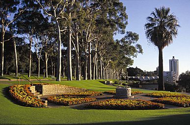
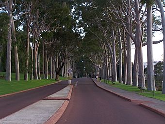
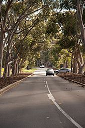
Kings Park Tourist Drive is Tourist Drive 200. It's a beautiful route through Kings Park. This park is right in the middle of Perth. The drive is 7 kilometers (about 4.3 miles) long.
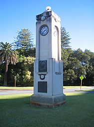
It starts at Fraser Avenue. This is the main entrance to the park. Tall Lemon-scented gum trees line the road. They were planted way back in 1938. The road leads to the State War Memorial. This memorial honors soldiers who died in wars.
From here, you get amazing views. You can see Perth's city center. The Swan River sparkles nearby. In the distance, you'll see the Darling Scarp hills. The drive then loops through the park. You'll pass the Botanical Gardens. There's also Synergy Parkland and playgrounds for kids. You'll also drive through natural bushland. The loop finishes back at the memorial. You can also enter the drive from other roads. These include Park Avenue, Poole Avenue, and Saw Avenue. Many paths cross the park for walking.
- Views along Kings Park Tourist Drive
-
Fraser Avenue precinct
-
Edith Cowan Memorial at park entrance
-
Lemon-scented Gums on Fraser Avenue
-
Lovekin Drive (near Botanical Gardens)
-
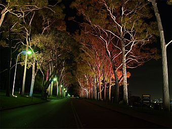
Fraser Avenue at night


Tourist Drive 201: John Forrest National Park
|
John Forrest Tourist Drive |
|
|---|---|
| Location: | John Forrest National Park |
| Length: | 10 km (10 mi) |
John Forrest Tourist Drive is Tourist Drive 201. It's a scenic route. It goes through John Forrest National Park. This park is in the eastern hills of Perth. The drive is 10 kilometers (about 6.2 miles) long.
It follows Park Road around the park. You can get to it from Great Eastern Highway. The drive shows off the park's plants and animals. You'll also find a lookout point. It offers great views of Perth. You can also see the edge of the Darling Scarp.
The drive also leads to Glen Brook Dam. This is a nice picnic spot. Many walking trails start here. There's also a visitors area. It has facilities and gardens. You can even find a swimming hole. Most of the park is untouched nature. The tourist drive stays in the southern part.
- Entrance to John Forrest Tourist Drive at Great Eastern Highway across from Bilgoman Pool
-
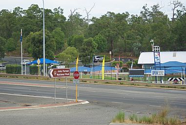
Start of tourist drive

Tourist Drive 202: Rockingham Coastline
|
Rockingham Coastal Tourist Drive |
|
|---|---|
| Location: | Rockingham |
| Length: | 24 km (15 mi) |
Rockingham Coastal Tourist Drive is Tourist Drive 202. It's a beautiful drive along the Rockingham coast. The route is 24 kilometers (about 15 miles) long.
It starts at Kwinana Beach. It then travels past Point Peron. You'll also go through Safety Bay. The drive ends in Warnbro. It uses several local roads. These include Kwinana Beach Road and Rockingham Beach Road. You'll also drive on The Esplanade and Point Peron Road.
- Views along Rockingham Coastal Tourist Drive
-
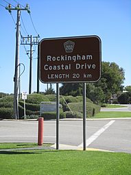
Rockingham Coastal Drive sign at the northern end, at the start of Kwinana Beach Road
-
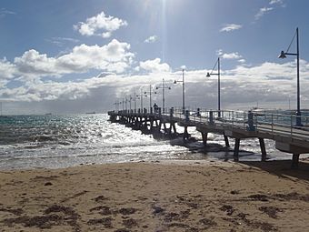
Palm Beach Jetty and Mangles Bay
-
Penguin Island Ferry


Tourist Drive 203: Swan Valley's Delights
|
Swan Valley Tourist Drive |
|
|---|---|
| Location: | Swan Valley |
| Length: | 31 km (19 mi) |
Swan Valley Tourist Drive is Tourist Drive 203. It takes you through Perth's Swan Valley. This drive is 31 kilometers (about 19 miles) long.
It's a loop that starts and ends in Guildford. You'll travel to West Swan. Then you'll go to Belhus and Midland. Finally, you return to Guildford. The drive uses roads like Meadow Street and West Swan Road. It also includes parts of Great Northern Highway.
Tourist Drive 204: Sunset Coast Beaches
|
Sunset Coast Tourist Drive |
|
|---|---|
| Location: | North Fremantle – Ocean Reef |
| Length: | 38 km (24 mi) |
Sunset Coast Tourist Drive is Tourist Drive 204. It's a scenic route along Perth's northern beaches. The drive is 38 kilometers (about 23.6 miles) long.
It has two main parts. They are connected by West Coast Highway. The first part starts at Stirling Bridge in North Fremantle. It goes through Cottesloe to Swanbourne.
The second part connects City Beach to Scarborough. It continues through Trigg and North Beach. Then it goes to Hillarys, Mullaloo, and ends at Ocean Reef. You'll drive on roads like West Coast Highway and West Coast Drive.
Tourist Drive 205: Heritage Country Loop
|
Heritage Country Tourist Drive |
|
|---|---|
| Location: | Bedfordale & Roleystone |
| Length: | 44 km (27 mi) |
Heritage Country Tourist Drive is Tourist Drive 205. It's a scenic and historic route. It goes through Bedfordale and Roleystone. The drive is 44 kilometers (about 27 miles) long.
It starts by heading east from Armadale. The route then forms a loop. It visits Churchman Brook Reservoir. It also goes to Canning Dam and Wungong Dam. Finally, it returns to Armadale. The drive follows roads like Albany Highway and Churchman Brook Road.
Tourist Drive 206: Kingsbury Forest Drive
|
Kingsbury Tourist Drive |
|
|---|---|
| Location: | Jarrahdale & Serpentine |
| Length: | 45 km (28 mi) |
Kingsbury Tourist Drive is Tourist Drive 206. It's a beautiful route. It goes through the jarrah forest. This forest is around Serpentine National Park. The drive is 45 kilometers (about 28 miles) long.
It's a loop that connects Jarrahdale. It also links Serpentine Dam and Serpentine National Park. You'll drive on Kingsbury Drive. Also, parts of South Western Highway and Jarrahdale Road.
Tourist Drive 207: Darling Range History
|
Darling Range Tourist Drive |
|
|---|---|
| Location: | Mundaring – Kalamunda |
| Length: | 25 km (16 mi) |
Darling Range Tourist Drive is Tourist Drive 207. It's a historic route. It's located in the Darling Range. This is near Mundaring. The drive is 25 kilometers (about 15.5 miles) long.
It follows Mundaring Weir Road. This road is between Mundaring and Kalamunda. The main highlight is the historic Mundaring Weir. This dam is part of a huge water system. It's called the Goldfields Water Supply Scheme. People call it "Western Australia's greatest engineering feat."
Tourist Drive 250: Caves Road Adventure
|
Caves Road Tourist Drive |
|
|---|---|
| Location: | Cape Naturaliste – Cape Leeuwin |
| Length: | 123 km (76 mi) |
Caves Road Tourist Drive is Tourist Drive 250. It's a scenic drive. It goes from Cape Naturaliste to Cape Leeuwin. It passes through the Leeuwin-Naturaliste National Park. The drive is 123 kilometers (about 76 miles) long.
Most of the route is on Caves Road. It also includes Cape Naturaliste Road. At the southern end, it follows Bussell Highway. Then Blackwood Avenue and Leeuwin Road. This takes you to Cape Leeuwin.
Tourist Drive 251: Blackwood River Views
|
Blackwood River Tourist Drive |
|
|---|---|
| Location: | Cape Naturaliste – Cape Leeuwin |
| Length: | 123 km (76 mi) |
Blackwood River Tourist Drive is Tourist Drive 251. It's a scenic route. It goes from Balingup to Bridgetown. It passes through Nannup.
Much of the drive from Balingup to Nannup follows the Blackwood River. This part is on Balingup–Nannup Road. The end of the route near Bridgetown also follows the river. This is on Brockman Highway. You can use South Western Highway to make a loop. This road connects Balingup and Bridgetown directly.
Tourist Drive 252: Porongurup National Park
|
Porongurup Tourist Drive |
|
|---|---|
| Location: | Mount Barker – Porongurup |
| Length: | 30 km (20 mi) |
Porongurup Tourist Drive is Tourist Drive 252. It's a scenic route. It goes from Mount Barker to Porongurup. It also leads to the Porongurup National Park. The drive is 30 kilometers (about 18.6 miles) long.
This route travels east to west. It's between Albany Highway and Chester Pass Road. You'll drive on Oatlands Road. Also, Mount Barker–Porongurup Road. The national park is known for many things. It has "many walks, spectacular views, interesting drives and abundant wildlife."
Tourist Drive 254: Avon Valley History
|
Avon Historic Tourist Drive |
|
|---|---|
| Location: | Toodyay – Beverley |
| Length: | 98 km (61 mi) |
Avon Historic Tourist Drive is Tourist Drive 254. It's a historic route. It goes through the Avon Valley. The drive is 98 kilometers (about 61 miles) long.
It travels next to the Avon River. It starts in Toodyay. Then it goes to Northam and York. It finishes in Beverley. The drive uses many different roads. These include Toodyay Road, Katrine Road, and Great Southern Highway.
Tourist Drive 255: Scotsdale Scenery
|
Scotsdale Tourist Drive |
|
|---|---|
| Location: | Denmark – William Bay National Park |
| Length: | 35 km (22 mi) |
Scotsdale Tourist Drive is Tourist Drive 255. It's a scenic route. It goes through coastal, forest, and farm areas. These are all around Denmark. The drive is 35 kilometers (about 21.7 miles) long.
It travels north-west from Denmark. It follows Scotsdale Road to Scotsdale. Then it goes south on Mount Mcleod Road. This connects to South Coast Highway. That highway leads to William Bay Road. This road goes through the William Bay National Park. It ends at Greens Pool. This is a calm beach on the southern coast.
Tourist Drive 256: Lake Argyle Wonders
|
Lake Argyle Tourist Drive |
|
|---|---|
| Location: | Lake Argyle |
| Length: | 34 km (21 mi) |
Lake Argyle Tourist Drive is Tourist Drive 256. It's 34 kilometers (about 21 miles) long. It connects Victoria Highway to Lake Argyle. This is near the Northern Territory border.
Lake Argyle is one of the world's biggest man-made lakes. You can also visit the Argyle Homestead Museum. There's a tourist village too. It used to be a construction camp. You can go bushwalking. The area has lots of animals. You might see birds, marsupials, and freshwater crocodiles. The only other sight along the way is the "rugged landscape" of the Kimberley.
Tourist Drive 257: Albany's Past
|
Albany Historic Tourist Drive |
|
|---|---|
| Location: | Albany |
| Length: | 6 km (4 mi) |
Albany Historic Tourist Drive is Tourist Drive 257. It's a historic route. It goes through Albany. Albany was Western Australia's first settlement. The drive is 6 kilometers (about 3.7 miles) long.
It runs along the coastline. It starts at Middleton Beach. It goes around Mount Adelaide. You'll pass Lawley Park. You'll also see the Old Post Office. It ends at the Western Australian Museum – Albany. The drive uses local roads. These include Marine Drive and Stirling Terrace.
Tourist Drive 258: Torndirrup National Park
|
Frenchman Bay Tourist Drive |
|
|---|---|
| Location: | Torndirrup National Park |
| Length: | 7 km (4 mi) |
Frenchman Bay Tourist Drive is Tourist Drive 258. It's a scenic route. It goes through the Torndirrup National Park. The drive is 7 kilometers (about 4.3 miles) long.
It follows Frenchman Bay Road. It goes from the park edge to Frenchman Bay. Many side roads lead to cool spots. These include The Gap. It's a narrow, steep canyon. The Natural Bridge looks like a giant's bridge. The Blowholes blast air from caves. Jimmy Newhill's Harbour is a natural port. Salmon Holes is a popular fishing spot.
Tourist Drive 259: Karri Forest Giants
|
Karri Tourist Drive |
|
|---|---|
| Location: | Manjimup – Quinninup |
| Length: | 88 km (55 mi) |
Karri Tourist Drive is Tourist Drive 259. It's a scenic route. It goes through the karri forest. This is south of Manjimup. The drive is 88 kilometers (about 55 miles) long.
Karri trees are huge. They can grow up to 85 meters (279 feet) tall. You'll also see streams and pools. The forest floor has ferns and vines. The route goes south from Manjimup. It follows Gilbert Street and South Western Highway. It turns off to Pemberton. Then it takes Vasse Highway to Northcliffe. Finally, it heads north-east to South Western Highway near Quinninup. There are many wildflowers and picnic spots along the way.
Tourist Drive 260: Australind to Bunbury
|
Australind Bunbury Tourist Drive |
|
|---|---|
| Location: | Leschenault – Bunbury |
| Length: | 14 km (9 mi) |
Australind Bunbury Tourist Drive is Tourist Drive 260. It's a 14-kilometer (about 8.7 miles) historic route. It goes from Leschenault to Bunbury. It passes through Australind, Western Australia.
The route starts at Forrest Highway. It travels south to Australind. This part is on Old Coast Road. It's east of the Leschenault Inlet. At Pelicon Point, it turns south-west. It follows Estuary Drive. It enters Bunbury after crossing the Preston River.
Tourist Drive 350: Geikie–Windjana Gorges
|
Geikie–Windjana Tourist Way |
|
|---|---|
| Location: | Geikie Gorge National Park – Windjana Gorge National Park |
| Length: | 166 km (103 mi) |
Geikie–Windjana Tourist Way is Tourist Drive 350. It's a 166-kilometer (about 103 miles) scenic route. It connects national parks in Western Australia's Kimberley region.
From Fitzroy Crossing, it goes north-east. It leads to Geikie Gorge National Park. This is along Forrest Road. It also travels west from town. This is on Great Northern Highway. It leads to Leopold Downs Road. This road turns off to Tunnel Creek National Park. The drive continues along Fairfield–Leopold Downs Road. It reaches Windjana Gorge National Park. It ends near the Lennard River. This route is only open in the dry season. That's from April to November.
Tourist Drive 351: Cossack Coastline
|
Cossack Tourist Way |
|
|---|---|
| Location: | Burrup Peninsula – Point Samson |
| Length: | 77 km (48 mi) |
Cossack Tourist Way is Tourist Drive 351. It's a 77-kilometer (about 48 miles) scenic and historic route. It's along the state's north-west coast.
From Dampier, it goes up the Burrup Peninsula. This is on Burrup Road. You can visit Woodside Petroleum's Visitors Centre. The Burrup Peninsula also has ancient Aboriginal rock carvings. These are thousands of years old. South-east of Dampier, the route goes to Karratha. Then it goes to the historic town of Roebourne. This is on Dampier Highway and North West Coastal Highway. North of Roebourne, the route splits. One part goes to the coastal ghost town of Cossack. The other goes via Wickham to Point Samson.
Tourist Drive 352: Cape Range Coastal Drive
|
Cape Range Tourist Way |
|
|---|---|
| Location: | North West Cape |
| Length: | 121 km (75 mi) |
Cape Range Tourist Way is Tourist Drive 352. It's a 121-kilometer (about 75 miles) scenic route. It goes along the coast of the North West Cape.
From Learmonth, it travels up the eastern side of the cape. It goes to Exmouth. This is via Minilya–Exmouth Road. It continues along Murat Road and Yardie Creek Road. It reaches the Vlaming Head Lighthouse. Then it follows Yardie Creek Road down the western side. It goes through the Cape Range National Park. It ends at Yardie Creek Gorge.
Tourist Drive 353: Shark Bay's Dolphins
|
Shark Bay Tourist Way |
|
|---|---|
| Location: | Shark Bay |
| Length: | 155 km (96 mi) |
Shark Bay Tourist Way is Tourist Drive 353. It's a 155-kilometer (about 96 miles) scenic route. It goes around Shark Bay. This is in the state's Gascoyne region.
The route follows Shark Bay Road and Monkey Mia Road. It starts near the Overlander Roadhouse. It passes Hamelin Pool Marine Nature Reserve and Denham. It ends at Monkey Mia. This place is famous for its wild but friendly bottlenose dolphins.
Tourist Drive 354: Batavia Coast Journey
|
Batavia Coast Tourist Way |
|
|---|---|
| Location: | Dongara – Kalbarri National Park |
| Length: | 244 km (152 mi) |
Batavia Coast Tourist Way is Tourist Drive 354. It's a 244-kilometer (about 152 miles) scenic route. It goes from Dongara to Kalbarri National Park. It follows the coast of the state's Mid West region.
The route uses Brand Highway and North West Coastal Highway. It turns inland to Kalbarri on Kalbarri Road. In town, it follows Clotworthy Street. It then goes south on Red Bluff Road. This road is next to the coast. It continues through the south-western part of Kalbarri National Park.
Tourist Drive 355: Collie Coalfield History
|
Collie Tourist Way |
|
|---|---|
| Location: | Roelands – Muja |
| Length: | 57 km (35 mi) |
Collie Tourist Way is Tourist Drive 355. It's a scenic and historic route. It goes around Western Australia's largest coalfield. The drive is 57 kilometers (about 35 miles) long.
It crosses the Darling Range on Coalfields Highway. It goes from Roelands to Collie River in Muja. It turns off at Centaur Road. This road runs alongside the river. It leads to the Muja Tourist lookout. From there, you can see the working coal mine. Along the way, you'll pass Wellington Dam. You'll also go through Collie. This is a historic coal mining town.
Tourist Drive 356: Great Southern Rail Journey
|
Great Southern Tourist Way |
|
|---|---|
| Location: | Beverley – Albany |
| Length: | 381 km (237 mi) |
Great Southern Tourist Way is Tourist Drive 356. It's a 381-kilometer (about 237 miles) historic route. It follows the Great Southern Railway. It goes from Beverley to Albany.
The route uses Great Southern Highway and Albany Highway. It passes through many towns. These towns started because of the railway. The railway is over 130 years old. Main attractions include Pingelly and Narrogin. Also, Wagin, Katanning, Cranbrook, and Mount Barker.
Tourist Drive 357: Goldfields History
|
Goldfields Tourist Way |
|
|---|---|
| Location: | Coolgardie – Kalgoorlie |
| Length: | 45 km (28 mi) |
Goldfields Tourist Way is Tourist Drive 357. It's a 45-kilometer (about 28 miles) historic route. It's in the state's goldfields area.
The route follows Great Eastern Highway. It starts west of Coolgardie. It goes to Kalgoorlie. You'll find the Coolgardie Camel Farm. Midway, there's the Kurrawang Emu Farm. They have carved emu eggs. This route is also part of the Golden Pipeline Heritage Trail. That trail was made in 2003. It celebrates the pipeline's 100th birthday.
Tourist Drive 358: Esperance Coastline
|
Esperance Tourist Way |
|
|---|---|
| Location: | Esperance |
| Length: | 30 km (20 mi) |
Esperance Tourist Way is Tourist Drive 358. It's a 30-kilometer (about 18.6 miles) scenic route. It goes along the Esperance coast. It also visits the nearby Pink Lake.
The route starts in Esperance's center. It follows Twilight Beach Road along the coast. You'll see many beaches and coves. Then it goes inland on Eleven Mile Beach Road to Pink Lake. The drive doesn't quite make a full circle. But Pink Lake Drive connects the two ends.
Tourist Drive 359: Chittering Valley Scenery
|
Chittering Valley Tourist Way |
|
|---|---|
| Location: | Wanneroo – Chittering |
| Length: | 70 km (40 mi) |
Chittering Valley Tourist Way is Tourist Drive 359. It's a 70-kilometer (about 43.5 miles) scenic route. It crosses the Gnangara-Moore River State Forest. It also goes through the Chittering Valley.
The route starts on Pinjar Road in Ashby. This is just north of Wanneroo. It heads east through the forest on Neaves Road to Bullsbrook. It follows Brockman River. It ends at Great Northern Highway. This is near Bindoon.
Tourist Drive 360: Midlands Wheatbelt
|
Midlands Tourist Way |
|
|---|---|
| Location: | Upper Swan – Watheroo National Park |
| Length: | 204 km (127 mi) |
Midlands Tourist Way is Tourist Drive 360. It's a 204-kilometer (about 127 miles) scenic and historic route. It goes through farming areas. These are in the state's Wheatbelt region. It's north of Perth.
From Upper Swan, it goes north. It follows Great Northern Highway to Walebing. Then it goes west on The Midlands Road to Moora. It continues north to Watheroo National Park. Along the way, you can see Walyunga National Park. Here, the Avon River becomes the Swan River (Western Australia). You'll also pass historic towns like Bindoon and New Norcia. North of Moora, you might see wildflowers.
