
Geography of Idaho facts for kids

The U.S. state of Idaho shares its borders with six other U.S. states and one Canadian province. To the west are Washington and Oregon. To the south are Nevada and Utah. And to the east are Montana and Wyoming. Idaho also has a short border with the Canadian province of British Columbia in the north.
Contents
Exploring Idaho's Amazing Landscape
Idaho is known for its wild and rugged natural areas. It has some of the biggest untouched natural spaces in the United States. For example, the Frank Church-River of No Return Wilderness Area is huge. It covers 2.3 million acres (930,000 hectares). This makes it the largest protected wilderness in the main part of the U.S.
Idaho is a Rocky Mountain state. It has lots of natural resources and beautiful places. You can find snow-capped mountains, rushing rivers, huge lakes, and deep canyons. The Snake River flows through Hells Canyon. This is the deepest gorge in the United States. Also, Shoshone Falls drops from cliffs even higher than Niagara Falls!
Idaho's Important Rivers
The most important river in Idaho is the Snake River. It is a major part of the Columbia River system. The Snake River starts in Yellowstone in northwestern Wyoming. It then flows through the Snake River Plain in southern Idaho. After that, it turns north and leaves the state near Lewiston. It later joins the Columbia River in Kennewick.
Other big rivers include the Clark Fork/Pend Oreille River and the Spokane River. Many important rivers also flow into the Snake River. These include the Clearwater River, the Salmon River, the Boise River, and the Payette River. The Salmon River joins the Snake in Hells Canyon. The Port of Lewiston is a special place. It is where the Clearwater and Snake Rivers meet. It is the farthest inland seaport on the West Coast. It is 465 river miles from the Pacific Ocean at Astoria, Oregon.
Living in Idaho's Valleys
Most of Idaho's people live in the Snake River Plain. This is a long valley that stretches across southern Idaho from east to west. Many major cities are in this valley. These include Boise, Meridian, Nampa, Caldwell, Twin Falls, Idaho Falls, and Pocatello.
This plain was an easy path through the Rocky Mountains for settlers moving west. Many settlers on the Oregon Trail chose to stay here. They did not want to risk the hard journey through the Blue Mountains and the Cascade Range further west. The western part of the plain is called the Treasure Valley. It is between the Owyhee Mountains to the southwest and the Boise Mountains to the northeast. The middle part of the Snake River Plain is known as the Magic Valley.
Idaho's Tallest and Lowest Points
Idaho's highest point is Borah Peak. It is 12,662 feet (3,859 meters) tall. It is in the Lost River Range north of Mackay. The lowest point in Idaho is in Lewiston. It is 710 feet (216 meters) above sea level. This is where the Clearwater River joins the Snake River.
The Sawtooth Range is often seen as Idaho's most famous mountain range. Other mountain ranges in Idaho are the Bitterroot Range, the White Cloud Mountains, the Lost River Range, the Clearwater Mountains, and the Salmon River Mountains. The only active glacier in Idaho is found at Borah Peak.
Minerals in Idaho
The Salmon-Challis National Forest is in the east-central part of the state. It includes the Salmon National Forest to the north and Challis National Forest to the south. This area is known as the Idaho Cobalt Belt. It has a 34-mile (55-kilometer) long geological formation of sedimentary rock. This rock contains some of the largest cobalt deposits in the U.S.
Idaho's Time Zones
Idaho has two time zones. The dividing line is about halfway between Canada and Nevada. Southern Idaho, including the Boise metropolitan area, Idaho Falls, Pocatello, and Twin Falls, are in the Mountain Time Zone. Areas north of the Salmon River are in the Pacific Time Zone. These areas include Coeur d'Alene, Moscow, Lewiston, and Sandpoint. Less than a quarter of Idaho's people and land are in the Pacific Time Zone.
Understanding Idaho's Climate

Idaho's climate changes a lot from one area to another. Even though the state's western border is about 330 miles (531 kilometers) from the Pacific Ocean, the ocean still affects Idaho's weather. This is especially true in winter. That is when clouds, humidity, and rain or snow are at their highest. The ocean makes winters milder. Temperatures are not as low as you might expect for a northern state with high elevations.
In the northern panhandle, moist air from the coast brings a lot of rain and snow. This creates a North American inland temperate rainforest. The ocean's influence is weakest in eastern Idaho. Here, the weather patterns are often opposite. Summers are wetter and winters are drier. Also, the temperature differences between seasons are much bigger. This area has a more semi-arid continental climate.
Idaho can get hot, but temperatures above 98°F (37°C) are rare. The exception is Lewiston, the lowest point in the state. It also gets very little snow. Boise usually gets about 18 inches (46 centimeters) of snow each year. Hot summer days are made more comfortable by low humidity and cooler evenings. This is because the biggest daily temperature changes often happen in summer. Winters can be cold, but long periods of bitter cold below zero are unusual. Idaho's highest temperature ever was 118°F (48°C). This was recorded in Orofino on July 28, 1934. The lowest temperature ever was -60°F (-51°C). This happened at Island Park Dam on January 18, 1943.
Climate Data for Idaho Cities
| Monthly normal high and low temperatures for various Idaho cities. (°F) | ||||||||||||
| City | Jan | Feb | Mar | Apr | May | Jun | Jul | Aug | Sep | Oct | Nov | Dec |
|---|---|---|---|---|---|---|---|---|---|---|---|---|
| Boise | 38/24 | 45/27 | 55/33 | 62/38 | 72/46 | 81/53 | 91/59 | 90/59 | 79/50 | 65/40 | 48/31 | 38/23 |
| Lewiston | 42/30 | 47/31 | 55/36 | 62/41 | 71/47 | 79/54 | 89/60 | 89/60 | 78/51 | 63/41 | 48/34 | 40/28 |
| Pocatello | 33/16 | 38/19 | 49/27 | 59/33 | 68/40 | 78/46 | 88/52 | 88/51 | 76/42 | 62/33 | 45/24 | 33/16 |
| Orofino | 38/25 | 46/28 | 55/32 | 64/38 | 72/44 | 80/50 | 89/54 | 90/53 | 79/45 | 63/36 | 46/31 | 37/26 |
| ' | ||||||||||||
Idaho's Beautiful Lakes and Rivers
Idaho is home to many stunning lakes and rivers. They are perfect for outdoor adventures!


- Clark Fork River
- Alturas Lake
- Bear River
- Bear Lake (Idaho–Utah)
- Boise River
- Clearwater River
- Hayden Lake
- Henry's Lake
- Kootenai River
- Lake Cascade
- Lake Cleveland
- Lake Coeur d'Alene
- Lake Lowell
- Lake Walcott
- Pend Oreille - Largest lake in Idaho
- Little Redfish Lake
- Lucky Peak Lake
- Moyie River
- North Fork Clearwater River
- Pack River
- Payette Lake, (McCall)
- Pettit Lake
- Priest Lake
- Perkins Lake
- Portneuf River
- Redfish Lake
- Sawtooth Lake
- Snake River - Longest river in Idaho
- Stanley Lake
- St. Joe River
- Warm Lake
Protected Natural Areas in Idaho
Idaho has many special places that are protected. These areas help keep nature safe for everyone to enjoy. Here are some of them as of 2018:
National Parks, Reserves, and Historic Sites
- Salmon-Challis National Forest
- California National Historic Trail
- City of Rocks National Reserve
- Craters of the Moon National Monument and Preserve
- Hagerman Fossil Beds National Monument
- Lewis and Clark National Historic Trail
- Minidoka National Historic Site
- Nez Perce National Historical Park
- Oregon National Historic Trail
- Yellowstone National Park
- Pacific Northwest National Scenic Trail
National Recreation Areas
- Hells Canyon National Recreation Area
- Sawtooth National Recreation Area
National Wildlife Refuges and Wilderness Areas
These places are set aside to protect animals and their homes.
- Bear Lake National Wildlife Refuge
- Camas National Wildlife Refuge
- Deer Flat National Wildlife Refuge
- Frank Church—River of No Return Wilderness Area
- Grays Lake National Wildlife Refuge
- Kootenai National Wildlife Refuge
- Minidoka National Wildlife Refuge
National Conservation Areas
- Snake River Birds of Prey National Conservation Area

Idaho State Parks

Idaho's state parks offer many fun activities and beautiful scenery.
- Bear Lake State Park
- Bruneau Dunes State Park
- Castle Rocks State Park
- City of Rocks National Reserve
- Coeur d'Alene Parkway State Park
- Dworshak State Park
- Eagle Island State Park
- Farragut State Park
- Harriman State Park
- Hells Gate State Park
- Henrys Lake State Park
- Heyburn State Park
- Lake Cascade State Park
- Lake Walcott State Park
- Land of the Yankee Fork State Park
- Lucky Peak State Park
- Massacre Rocks State Park
- McCroskey State Park
- Old Mission State Park
- Ponderosa State Park
- Priest Lake State Park
- Round Lake State Park
- Thousand Springs State Park
- Three Island Crossing State Park
- Trail of the Coeur d'Alenes
- Winchester Lake State Park
Images for kids
-
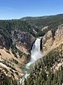
A part of Yellowstone National Park is in Idaho. Other parts are in Montana and Wyoming.

