Iranian Plateau facts for kids
Quick facts for kids Iranian Plateau |
|
|---|---|
| Persian Plateau | |

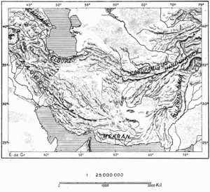
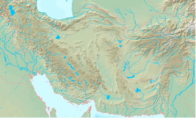
Topographic map of the Iranian Plateau, connected to the Armenian highlands and Anatolia in the west, and to the Hindu Kush and the Himalayas in the east
|
|
| Location | Central Asia, South Asia, West Asia (including the South Caucasus) |
| Part of | Afghanistan, Azerbaijan, Iran, Iraq (Iraqi Kurdistan), (Khyber Pakhtunkhwa) (Baluchistan), and Turkmenistan |
| Highest point – elevation |
Noshaq 7,492 m (24,580 ft) |
| Length | 2,000 km (1,200 mi) |
| Area | 3,700,000 km2 (1,400,000 sq mi) |
| Geology | Eurasian Plate |
The Iranian Plateau, also known as the Persian Plateau, is a huge land area in Asia. It covers parts of Central Asia, South Asia, and West Asia. This plateau is part of the Eurasian Plate, which is one of Earth's large tectonic plates. It sits between the Arabian Plate and the Indian Plate.
The plateau has natural borders all around it. To the west are the Zagros Mountains. To the north, you'll find the Caspian Sea and the Köpet Dag mountains. The Armenian highlands and Caucasus Mountains are to the northwest. To the south are the Strait of Hormuz and the Persian Gulf. Finally, the Indian subcontinent lies to its east.
Historically, this region was home to ancient kingdoms like Parthia and Media. Even though it's called a plateau, it's not flat at all! It has many mountain ranges. The highest point is Noshaq in the Hindu Kush mountains, which is about 7,492 meters (24,580 feet) tall. The lowest point is the Lut Desert in Iran, which is below 300 meters (980 feet). The Iranian Plateau stretches for about 2,000 kilometers (1,200 miles). It covers a big part of Iran, all of Afghanistan, and parts of Pakistan west of the Indus River. This whole area is about 3,700,000 square kilometers (1,400,000 square miles).
Contents
How the Plateau Formed
The Iranian Plateau was mainly formed when the Arabian Plate slowly pushed into the Eurasian continent. This pushing and colliding of Earth's plates created the mountains and raised land we see today. Scientists study this area a lot. This is because it's a great example of what happens when continents collide.
Where is the Iranian Plateau?
In terms of geology, the Iranian Plateau is the land north of the big mountain belts. These mountains were formed by the collision of the Arabian Plate and the Eurasian Plate. So, the southwestern part of Iran is not usually included in this geological definition.
The plateau stretches from the northwest of Iran all the way to Afghanistan and parts of Pakistan. It also includes smaller areas of Azerbaijan, Iraqi Kurdistan, and Turkmenistan.
The northwestern part of the Iranian Plateau is very rugged. It has high mountains like the Anti-Taurus range. The weather here is often harsh, with lots of rain and snow. Mount Ararat, Turkey's highest point at 5,137 meters (16,854 feet), is in this region. Lake Van is also found here, sitting high in the mountains.
Many important rivers start in the Anti-Taurus mountains. The Aras River flows east into the Caspian Sea. The Euphrates and Tigris rivers flow south, joining in Iraq before reaching the Persian Gulf. The Indus River starts in Tibet and flows along the eastern edge of the plateau through Pakistan.
South of the Anti-Taurus Mountains is Southeast Anatolia. This area has rolling hills and a wide plateau that extends into Syria. The land gets lower as you go south. Farmers here traditionally grow wheat and barley.
Mountain Ranges of the Plateau
The Iranian Plateau has several important mountain ranges. They are grouped into five main areas:
Northwest Iranian Mountains
- Alborz
- Damavand (5,610 meters or 18,406 feet)
Southwest Iranian Mountains
- Zagros
- Dena (4,409 meters or 14,465 feet)
Central Iranian Plateau Mountains
- Kūh-e Hazār (4,500 meters or 14,764 feet)
- Kuh-e Jebal Barez
Eastern Iranian Mountains
- Kopet Dag
- Kuh-e Siah Khvani (3,314 meters or 10,873 feet)
- Eshdeger Range
- (2,920 meters or 9,580 feet)
- Balochistan
- Sikaram (4,755 meters or 15,590 feet)
- Kuh-e Taftan (3,941 meters or 12,930 feet)
- Zargun (3,578 meters or 11,739 feet)
Rivers and Flat Areas
The plateau also has large deserts and important river basins:
- Kavir Desert
- Lut Desert
- Hamun-e Jaz Murian
- Halil River
- Gavkhouni
- Zayandeh River
- Sistan Basin
History of the Plateau
The Iranian Plateau might have been a very important place for early humans. After humans moved out of Africa, this plateau may have been a "population hub." From here, different groups of people spread out across Europe and Asia around 50,000 years ago.
During the Bronze Age, the ancient kingdom of Elam stretched across the Zagros mountains. This connected Mesopotamia with the Iranian Plateau. Later, the region became known as Persia. This was because the Achaemenid dynasty came from the Fars region of Persia.
Ancient Discoveries
Many important archaeological sites have been found on the Iranian Plateau. These sites help us learn about ancient cultures. Some famous ones include:
- Mehrgarh: This site is a predecessor to the Indus Valley civilization.
- Central Iranian Plateau ("Jiroft culture")
- Shahr-i Sokhta
- Konar Sandal
- Tepe Yahya
- Zayandeh River Civilization
- Tappeh Sialk
- Paleolithic sites (from the Stone Age)
- Niasar
- Sefid-Ab
- Kaftar Khoun
- Qaleh Bozi Caves
- Mirak
- Delazian
- Tabas
- Masileh
Plant Life
The Iranian Plateau has historical forests of oak and poplar trees. Oak forests are common around the city of Shiraz. You can also find aspen, elm, ash, willow, walnut, pine, and cypress trees. Poplar wood was used to make doors in the past. Elm wood was used for ploughs.
For decoration, people used trees like acacia, cypress, and Turkestan elm. The plateau is also home to beautiful flowers like lilac, jasmine, and roses. Hawthorn and Cercis siliquastrum are common shrubs. Their branches are often used for basket weaving.
Animal Life
The plateau is rich in wildlife. You can find leopards, bears, hyenas, wild boars, ibex, gazelles, and mouflons. These animals mostly live in the wooded mountain areas. Near the shores of the Caspian Sea and the Persian Gulf, you can see water birds like seagulls, ducks, and geese.
In the semi-desert areas, there are deer, hedgehogs, foxes, and many types of rodents. Palm squirrels and Asiatic black bears live in the Baluchistan region.
A wide variety of amphibians and reptiles also live here. These include toads, frogs, tortoises, lizards, salamanders, and different kinds of snakes like racers and vipers. The Persian Gulf is home to about 200 types of fish. The Caspian Sea is known for its Sturgeon, which is an important commercial fish.
Economy and Agriculture
The Iranian Plateau is important for farming and growing various crops. Trees are harvested for making doors, ploughs, and baskets. Many kinds of fruit are grown here. In the 20th century, common fruits included pears, apples, apricots, quince, plums, nectarines, cherries, mulberries, and peaches.
In warmer areas, almonds and pistachios are common. Other fruits like dates, oranges, grapes, melon, and limes are also grown. Vegetables like potatoes and cauliflower became easier to grow after irrigation improved. Other vegetables include cabbage, tomatoes, artichokes, cucumbers, spinach, radishes, lettuce, and eggplants.
The plateau also produces wheat, barley, millet, beans, cotton, lucerne, and tobacco. Barley is mainly used to feed horses. Sesame is grown to make sesame oil. In the early 1900s, mushrooms and manna were also found. Caraway is grown in the Kerman Province.
See also
 In Spanish: Meseta iraní para niños
- Biosphere reserves of Iran
- Geography of Iran
- List of Iranian four-thousanders
 | Roy Wilkins |
 | John Lewis |
 | Linda Carol Brown |


