
Sahara facts for kids
This article is about the desert. The article about the country can be found at Western Sahara
Quick facts for kids Sahara |
|
|---|---|

The Sahara taken by Apollo 17 astronauts, 1972
|
|

Geographical map of the Sahara
|
|
| Length | 4,800 km (3,000 mi) |
| Width | 1,800 km (1,100 mi) |
| Area | 9,200,000 km2 (3,600,000 sq mi) |
| Geography | |
| Countries | |

The Sahara is a huge desert in North Africa. It is one of the largest deserts on Earth. Even though it's very big, Antarctica is actually a larger desert.
The Sahara is surrounded by the Atlantic Ocean, the Atlas Mountains, the Mediterranean Sea, the Red Sea, and the Sahel region. Many countries have parts of the Sahara within their borders. These include Morocco, Algeria, Tunisia, Libya, Egypt, Mauritania, Mali, Niger, Chad, and Sudan. Most of the Sahara is empty, but some people live in places where water can be found.
The Sahara Desert covers about 9,065,000 square kilometers (about 3.5 million square miles). This is roughly the same size as the entire United States. The desert has changed in size over time, sometimes growing larger and sometimes shrinking. After the last ice age, it was more fertile before drying up again. It is known as the hottest place on Earth, but it is not the driest. The driest desert is the Atacama Desert in South America.
Contents
Climate and Weather in the Sahara

The Sahara is the world's largest hot desert. It gets very little to no rain. The climate here is hot and dry all year round.
Most of the rain in the Sahara comes from something called the Intertropical Convergence Zone. This is a low-pressure belt near the equator. It brings short, irregular rainy seasons to the Sahel region and the southern Sahara.
Rainfall in this huge desert is very rare. The Sahara's harsh climate has several key features:
- Very low and unpredictable rainfall.
- Extremely long hours of sunshine.
- High temperatures all year.
- Very low relative humidity.
- Big changes in temperature between day and night.
- Extremely high rates of potential evaporation, which means water evaporates very quickly.
Geography of the Sahara Desert


The Sahara covers large parts of many countries. These include Algeria, Chad, Egypt, Libya, Mali, Mauritania, Niger, Western Sahara, and Sudan. It also touches southern Morocco and Tunisia. The desert makes up about 31% of the African continent. It is so vast and bright that, in theory, it could be seen from other stars as a feature of Earth.
The Sahara is mostly made up of rocky hamada (stone plateaus). Large areas covered with sand dunes, called ergs, make up a smaller part. However, many of these sand dunes can be over 180 meters (590 feet) high. Wind and rare rainfall shape the desert's features. These include sand dunes, stone plateaus, gravel plains (reg), dry valleys (wadi), dry lakes (oued), and salt flats (shatt or chott). One unusual landform is the Richat Structure in Mauritania.
Several mountains rise from the desert. Many of these are volcanic. They include the Aïr Mountains, Ahaggar Mountains, Saharan Atlas, Tibesti Mountains, Adrar des Iforas, and the Red Sea Hills. The highest point in the Sahara is Emi Koussi. It is a volcano in the Tibesti range in northern Chad.
The central Sahara is extremely dry, with very few plants. The northern and southern edges of the desert, along with the highlands, have some sparse grasslands and desert shrubs. Trees and taller shrubs grow in wadis, where water collects. In the super-dry central region, there are many smaller deserts. These include the Tanezrouft, the Ténéré, the Libyan Desert, the Eastern Desert, and the Nubian Desert. These areas often get no rain for years.
To the north, the Sahara borders the Mediterranean Sea in Egypt and parts of Libya. In other areas, it meets Mediterranean forests, woodlands, and scrub regions. These areas have hot summers and cool, rainy winters. The northern edge of the Sahara is where date palm trees stop growing and a grass called esparto begins. This line also matches where annual rainfall is about 100 millimeters (4 inches).
To the south, the Sahara meets the Sahel. The Sahel is a dry belt of tropical savanna. It stretches across Africa from east to west and has a summer rainy season. The southern edge of the Sahara is marked by the plant Cornulaca monacantha. It also matches where annual rainfall is about 150 millimeters (6 inches).
Important cities in the Sahara include Nouakchott (the capital of Mauritania), Tamanrasset in Algeria, Timbuktu in Mali, and Faya-Largeau in Chad.
Different Parts of the Sahara

The Sahara is made up of several different ecoregions. These regions have different temperatures, rainfall, elevations, and soils. Because of these differences, they are home to unique groups of plants and animals.
- The Atlantic coastal desert is a narrow strip along the Atlantic coast. Fog from the cool Canary Current provides enough moisture for lichens, succulents, and shrubs. It covers about 39,900 square kilometers (15,400 sq mi) in southern Morocco and Mauritania.
- The North Saharan steppe and woodlands is along the northern edge of the desert. Winter rains support shrubs and dry woodlands. These areas form a transition zone between the Mediterranean climate regions to the north and the very dry Sahara to the south. It covers about 1,675,300 square kilometers (646,800 sq mi).
- The Sahara desert ecoregion covers the super-dry central part of the Sahara. Here, rainfall is very low and happens only sometimes. Plants are rare. This region mostly has sand dunes, stone plateaus, gravel plains, dry valleys, and salt flats. It covers about 4,639,900 square kilometers (1,791,500 sq mi).
- The South Saharan steppe and woodlands is a narrow band between the super-dry Sahara and the Sahel savannas to the south. Summer rains in July and August bring about 100 to 200 millimeters (4 to 8 inches) of rain. These rains support summer pastures of grasses and herbs. This ecoregion covers about 1,101,700 square kilometers (425,400 sq mi).
- In the West Saharan montane xeric woodlands, several volcanic highlands offer cooler, wetter conditions. These support woodlands and shrublands. This ecoregion covers about 258,100 square kilometers (99,700 sq mi).
- The Tibesti-Jebel Uweinat montane xeric woodlands ecoregion includes the Tibesti and Jebel Uweinat highlands. More regular rainfall and cooler temperatures support woodlands and shrublands. These include date palms, acacias, myrtle, and other plants. It covers about 82,200 square kilometers (31,700 sq mi).
- The Saharan halophytics are areas of salty depressions that flood seasonally. They are home to halophytic (salt-adapted) plants. These areas cover about 54,000 square kilometers (21,000 sq mi).
- The Tanezrouft is one of the Sahara's driest regions. It has no plants and very little life. It is a flat gravel plain that stretches south of Reggane in Algeria.
Plants and Animals of the Sahara
The plants in the Sahara are very diverse. This is due to the different geographical features of this huge desert. The Sahara has three main plant zones based on how much rain they get: the Northern (Mediterranean), Central, and Southern Zones. There are also two transition zones.
The Sahara is home to about 2,800 types of vascular plants. About a quarter of these are endemic, meaning they are found only there. About half of these species are also found in the Arabian deserts.

The central Sahara is thought to have about 500 plant species. This is a very low number for such a huge area. Plants like acacia trees, palms, succulents, spiny shrubs, and grasses have adapted to the dry conditions. They grow low to the ground to avoid losing water from strong winds. They store water in their thick stems for dry times. They have long roots that spread out to find any moisture. Their small, thick leaves or needles help prevent water loss through evapotranspiration. Some plant leaves can dry out completely and then recover when water is available.
Animals of the Sahara
Several types of fox live in the Sahara. These include the fennec fox, pale fox, and Rüppell's fox. The addax, a large white antelope, can go almost a year without drinking water. The dorcas gazelle is a North African gazelle that can also survive a long time without water. Other notable gazelles are the rhim gazelle and dama gazelle.
The Saharan cheetah (also called the northwest African cheetah) lives in Algeria, Niger, and Mali. There are fewer than 250 of these cheetahs left. They are very shy and run away from humans. They are active from April to October, seeking shade under shrubs like balanites and acacias. They are unusually pale in color. Another cheetah type, the northeast African cheetah, lives in Chad and Sudan. There are about 2,000 of these cheetahs left in the wild.

Other animals in the Sahara include monitor lizards, hyrax, sand vipers, and small groups of African wild dog. You can also find red-necked ostrich. Many birds live in the Sahara, such as the African silverbill and black-faced firefinch. There are even small desert crocodiles in Mauritania and Chad.
The deathstalker scorpion can be up to 10 centimeters (4 inches) long. Its venom is very dangerous, but a sting rarely kills a healthy adult. The Saharan silver ant is special because it is only active outside its nest for about ten minutes a day. This is due to the extremely high temperatures and the threat of predators.
Dromedary camels and goats are the most common domesticated animals in the Sahara. Camels are favored by nomads because they are strong and fast.
Human activities can affect the environment in areas with permanent water, like oases. Here, the pressure on natural resources can be high. Hunting for food and fun has greatly reduced the number of large mammals. In recent years, development projects in Algeria and Tunisia have used water pumped from underground. These projects can sometimes lead to soil degradation and salinization, where the soil becomes too salty.
Scientists have found that Saharan soil may contain useful iron and other nutrients. These could be used as fertilizer for growing wheat.
History of the Sahara

People have lived on the edge of the desert for thousands of years, since the end of the last ice age. In the Central Sahara, people created engraved and painted rock art as early as 10,000 years ago. The Sahara was much wetter back then. Over 30,000 petroglyphs (rock carvings) of river animals like crocodiles have been found. Half of these are in the Tassili n'Ajjer in southeast Algeria. Fossils of dinosaurs, including Afrovenator and Ouranosaurus, have also been found here.
Today, the Sahara is not full of plants, except in the Nile Valley, at a few oases, and in the northern highlands. In these northern areas, Mediterranean plants like the olive tree can grow. About 5,400 years ago, changes in Earth's axis caused temperatures to rise and rainfall to decrease. This led to the Sahara becoming a desert very quickly.
Ancient People of the Sahara
Kiffian Culture
The Kiffian culture was a group of people who lived in the Sahara between 10,000 and 8,000 years ago. This was during a wet period called the Neolithic Subpluvial. Human remains from this culture were found in 2000 at a site called Gobero in Niger. This site is the largest and oldest Stone Age burial ground in the Sahara.
The Kiffians were skilled hunters. Bones of large savannah animals found nearby suggest they lived by a lake. This lake existed during a time when the Sahara was green and wet. Kiffian people were tall, often over six feet. They were related to other ancient groups in North Africa. After 8,000 years ago, the Sahara became dry again for about a thousand years, and traces of the Kiffian culture disappear.
Tenerian Culture
Gobero was discovered in 2000 by an archaeological team looking for dinosaur remains. They found two different ancient cultures there: the Kiffian and the Tenerian culture. The dry period after the Kiffians ended around 4600 BCE. The oldest items from the Tenerians date back to this time.
About 200 skeletons have been found at Gobero. The Tenerians were shorter and less strong than the Kiffians. Their skulls were also different, more like people from the Mediterranean region. Graves show that the Tenerians had spiritual traditions. They were buried with items like jewelry made from hippo tusks and clay pots.
One amazing find is a triple burial from 5,300 years ago. It contained an adult woman and two children, aged five and eight, hugging each other. Pollen suggests they were buried on a bed of flowers. They likely died within 24 hours of each other, but the cause of their deaths is a mystery.
Nubians and Egyptians

During the Neolithic Era, before the Sahara became a desert around 9500 BCE, central Sudan was a rich environment. It supported a large population. By 5000 BCE, people in Nubia were farming and raising animals. Rock art shows they had a cattle cult, similar to groups in Sudan today.
Large stone structures found at Nabta Playa are thought to be the world's first known archaeoastronomy devices. They are about 2,000 years older than Stonehenge. This complex society in Nubia likely helped form the structure of early Egyptian society.
By 6000 BCE, early Egyptians in the southwest were raising cattle and building large structures. Their lives centered on farming cereals and animals like cattle, goats, pigs, and sheep. They also worked with metal, tanned animal skins, made pottery, and wove cloth.
By 3400 BCE, the Sahara was as dry as it is today. This was due to less rain and higher temperatures from a shift in Earth's orbit. The desert became a huge barrier for people. Settlements were mainly found around the many oases. Little trade happened through the desert, except along the Nile Valley. However, the Nile had several cataracts, making boat travel difficult.
Tichitt Culture
Around 4000 BCE, a complex social structure began to develop among herders in the Sahara. This included trading cattle as valuable goods. By 1800 BCE, this Saharan herding culture had spread across the Sahara and Sahel regions.
The Tichitt culture, in eastern Mauritania, existed from 2200 BCE to 200 BCE. This culture had a four-level social structure, farmed cereals, used metallurgy, built many tombs, and created rock art. They may have also started growing pearl millet independently. The Tichitt culture may have been the earliest large, complex society in West Africa. It might have led to the formation of states in West Africa.
Iron tools were found from the 1st millennium BCE. Copper was also used. After its decline in Mauritania, the Tichitt culture spread to the Middle Niger region of Mali. It later developed into the Ghana Empire in the 1st millennium CE.
Phoenicians and Greeks

The people of Phoenicia, who lived from 1200 to 800 BCE, built settlements along the North African coast. They traded a lot with the local people. This connected them with the ancient Libyans, who were ancestors of today's Berber speakers in North Africa and the Sahara.
The ancient Libyan alphabet seems to have been based on Phoenician. Its descendant, Tifinagh, is still used by the Tuareg of the central Sahara today.
By 500 BCE, Greeks arrived in the desert. Greek traders set up trading posts along the Red Sea. The Carthaginians explored the Atlantic coast. However, rough waters and few markets meant they didn't go much further south than modern Morocco. This meant that the desert remained outside the control of these powerful states. Raids from nomadic Berber people were a constant worry for those living near the desert.
Garamantes Civilization

An urban civilization called the Garamantes appeared around 500 BCE. They lived in the heart of the Sahara, in a valley in Fezzan, Libya. The Garamantes built a successful empire in the desert. They did this by digging long tunnels into the mountains to reach fossil water and bring it to their fields.
The Garamantes grew strong and conquered their neighbors. They captured and enslaved many people, forcing them to extend the tunnels. The ancient Greeks and Romans knew about the Garamantes. They traded with them, and a Roman bath was found in the Garamantes' capital, Garama. Archaeologists have found eight major towns and many other settlements in their territory.
The Garamantes' civilization eventually collapsed. This happened because they used up the available water in the aquifers. They could no longer keep digging tunnels further into the mountains. Between the 1st century BCE and the 4th century CE, several Roman expeditions went into the Sahara.
Islamic Expansion and Trade
The Byzantine Empire ruled the northern parts of the Sahara from the 5th to the 7th centuries. After the Muslim conquest of Arabia, the Muslim conquest of North Africa began in the mid-7th century. Islamic influence quickly spread across the Sahara. By the end of 641, all of Egypt was under Muslim control.
Trade across the desert grew, and a large slave trade developed. It is estimated that from the 10th to the 19th centuries, about 6,000 to 7,000 enslaved people were taken north each year.
The Beni Ḥassān and other nomadic Arab tribes took control of the Sanhaja Berber tribes in the western Sahara after a war in the 17th century. As a result, Arabian culture and language became dominant.
European Colonialism
European colonialism in the Sahara started in the 19th century. France conquered Algeria from the Ottomans in 1830. French rule then spread south and east. This included present-day Algeria, Chad, Mali, Mauritania, Niger, and Tunisia. By the early 20th century, trade across the Sahara had declined. Goods were now moved by more modern ways, like airplanes.

The French Colonial Empire was the main power in the Sahara. They set up regular air routes from Toulouse to Oran and over the Hoggar Mountains to Timbuktu. They also had bus services across the Sahara. A film from 1933 shows the first crossing by a large truck convoy from Algiers to Chad.
Egypt, under Muhammad Ali and his successors, conquered Nubia in 1820–22. Egypt, including Sudan, became a British protectorate in 1882. Spain took control of present-day Western Sahara after 1874. In 1912, Italy captured parts of what would become Libya from the Ottomans.
Modern Sahara and Its Future

.jpg)
Egypt became independent from Britain in 1936. Most of the Saharan states gained independence after World War II. Libya in 1951, Morocco, Sudan, and Tunisia in 1956, Chad, Mali, Mauritania, and Niger in 1960, and Algeria in 1962. Spain left Western Sahara in 1975. Mauritania later withdrew, but Morocco still controls the territory.
Tuareg people in Mali have rebelled several times. Islamist rebels in the Sahara have increased their violence in recent years.
After World War II, several mines and communities developed to use the desert's natural resources. These include large deposits of oil and natural gas in Algeria and Libya. There are also large deposits of phosphates in Morocco and Western Sahara. Libya's Great Man-Made River is the world's largest irrigation project. It uses pipelines to pump fossil water from underground to cities on the Libyan coast.
Several Trans-African highways have been planned across the Sahara. These include the Cairo–Dakar Highway and the Trans-Sahara Highway. Each of these highways is partly finished, but they still have big gaps and unpaved sections.
People, Culture, and Languages

The people of the Sahara come from different backgrounds. They include the Amazigh, like the Tuareg. There are also Arabized Amazigh groups, such as the Hassaniya-speaking Sahrawis. Other major groups are the Toubou, Nubians, Zaghawa, Kanuri, Hausa, Songhai, Beja, and Fula/Fulani.
Archaeological evidence shows that Nilo-Saharan speaking groups lived in the central and southern Sahara before Berber and Arabic speakers arrived about 1,500 years ago. Today, Arabic dialects are the most widely spoken languages in the Sahara. Arabic, Berber, and Beja languages are part of the Afro-Asiatic family.
Unlike neighboring West Africa, the French language is not very important for daily talks and trade in the Sahara. People in the region keep strong ties to Tuareg and Berber leaders and culture. The legacy of French colonial rule is mostly seen in the new borders they created. These borders divided a region that used to be more open. Diplomacy with local groups was mainly done in Arabic, which was the traditional language for official matters.
Images for kids
-
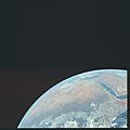
The Sahara desert taken in space by Apollo 17 crew
-
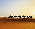
Sunset in Sahara
-
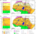
Vegetation and water bodies in the Eemian (bottom) and Holocene (top)
-
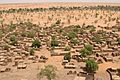
Sahel region of Mali
.jpg)


See also
 In Spanish: Desierto del Sahara para niños
