
History of Hobart facts for kids
Hobart, once called 'Hobart Town', is a city in Tasmania, Australia. It was founded in 1804 as a British colony. Before the British arrived, the area was home to the Mouheneener tribe for thousands of years. These people were part of the Nuenonne group. Today, their descendants are known as 'Palawa'.
Hobart started as a penal colony in 1803 at Risdon Cove. This was because Britain was worried about French explorers in the area. In 1804, the settlement moved to a better spot at Sullivans Cove. This makes Hobart the second oldest city in Australia.
For many years, the city's past as a convict settlement was a big part of its identity. Many old buildings from that time, called Georgian architecture, reminded people of this history. But many former convicts were hard-working. They started businesses and families that are still important in Tasmania today.
Hobart has grown from a small area around Sullivans Cove. It now stretches along both sides of the Derwent River. The city is built on low hills at the base of Mount Wellington. Since 1856, when Tasmania gained self-government, Hobart has been its capital city.
Hobart's growth has been slow because it is far away from other places. It has had times of economic success and difficulty. It went from a defensive outpost to a major center for whaling and shipbuilding. But then it faced a big economic downturn in the late 1800s.
The early 1900s brought new growth from mining and farming. But the world wars caused a loss of many working-age men. After the wars, many new people moved to Hobart from Europe. Later, more migrants came from Asia. Even with these new arrivals, most people in Hobart are of Anglo-Celtic background.
Hobart is an important deep-water port for ships heading to the Southern Ocean. It is the last stop for Australian and French trips to Antarctica. Many naval ships also visit Hobart because of the deep harbour.
The city's look is shaped by its location and history. You can see many old buildings in Georgian, Victorian, and Edwardian architecture styles. These buildings give Hobart its special character.
Recently, tourism has grown in Hobart. Many people are moving there because it costs less to live there and has a relaxed lifestyle. Even though Hobart has grown slower than other Australian cities, it has a steady population, a good economy, a clean environment, and a lively sports, arts, and culture scene.
Contents
- What Does the Name Hobart Mean?
- Where is Hobart Located?
- Who Lived in Hobart Before Europeans?
- Who Explored Hobart First?
- How Did British Settlement Begin in 1803?
- Hobart's Convict Past
- Hobart's Early Years (Early 1800s)
- Hobart in the Mid-1800s
- Hobart in the Late 1800s
- Hobart in the Early 1900s
- Hobart in the Late 1900s
- Hobart in the 21st Century
- How Has Hobart's Population Changed?
- Important Historical Places in Hobart
- Images for kids
What Does the Name Hobart Mean?
The name Hobart comes from Robert Hobart, 4th Earl of Buckinghamshire, who was an important British official. The first Lieutenant-Governor of Van Diemen's Land, David Collins, named the new settlement after him.
It was first called 'Hobart Town' or 'Hobarton'. By 1842, it was big enough to be called a city. From 1881, the 'Town' was officially dropped, and it became simply 'Hobart'.
Where is Hobart Located?

Hobart is in the southeastern part of Tasmania, at 42°S, 147°E. It is about 22 kilometers from where the Derwent River meets Storm Bay. Hobart is built around Sullivans Cove, a small bay where the Hobart Rivulet joins the Derwent River. This spot was chosen because it has a deep harbour for ships, a sheltered area for boats, and fresh water from the Hobart Rivulet.
Most of the city is along the western side of the Derwent River. But there are also many homes on the eastern side. The eastern side has low hills and a small mountain range called the Meehan Range. The western side is flat near the water but rises steeply into foothills.
Deep valleys are found between the hills, which are usually 500 to 800 meters high. Mount Wellington is the most famous part of the Wellington Range. The Derwent Valley stretches north with flat farmland and green hills following the river.
Who Lived in Hobart Before Europeans?

Not much is known about the Hobart area before Europeans arrived. When the British settled, about 1,000 to 5,000 Aboriginal people lived in Tasmania, divided into eight groups. The Mouheneener tribe, part of the Nuennone or 'South-East' tribe, were the first to be affected by European settlement. Hobart Town was built on their traditional hunting lands.
The Nuenonne people did not have permanent homes. They were nomadic hunter-gatherers, meaning they moved around to find food. Early Europeans said the Nuenonne lived in simple bark huts around fires.
French explorers described them as friendly and peaceful. Captain James Cook also wrote about them when he visited the Derwent River in 1777. At first, the Nuenonne were welcoming to European explorers. They would exchange food and water for small items. They thought the European ships were spirits riding on giant birds. But soon, tension grew as they realized the British planned to stay.
By the 1820s, European settlements were expanding across the island. This meant less land for Aboriginal people, who began to fight back. Clashes became more common, and killings happened on both sides. Many Aboriginal people died during this time. The conflict became so bad that martial law was declared, leading to the Black War.
By 1831, only about 200 Aboriginal people were left. Attempts to move them to Flinders Island led to more deaths from European diseases like smallpox and influenza. By 1847, only 44 native Tasmanians remained. The last full-blooded Aboriginal Australian, Trugannini, died in 1876. Today, their descendants are people of mixed heritage.
The growth of Hobart has destroyed much of the old evidence of Aboriginal life. But Aboriginal middens (piles of shells and other waste) can still be found in coastal areas. This makes it hard for scientists to fully understand their way of life before Europeans arrived.
Who Explored Hobart First?

The first Europeans to see Tasmania were Dutch sailors led by Abel Janszoon Tasman in 1642. They named it Van Diemen's Land. They did not meet the local people, but their ships might have inspired myths about spirits riding seabirds.
The next visit to the Derwent River was by French explorer Marc-Joseph Marion du Fresne in 1773. As France and Britain became rivals, both sent scientific trips to the area.
English explorers Tobias Furneaux (in 1773) and James Cook (in 1777) both said the Derwent shores were good for resupplying ships. William Bligh, who was on Cook's ship, returned to the Derwent River in 1788 on his famous ship, the Bounty.
In the 1790s, French explorers Bruni d'Entrecasteaux and Jean-Michel Huon de Kermadec sailed into the river in 1793. They mapped it more closely and named it 'Riviere du Nord'. They also planted a vegetable garden at Recherche Bay for future trips.
A few months later, English captain Sir John Hayes also stopped there. He named the river the 'Derwent River', after a river in England.
George Bass and Matthew Flinders visited in 1798 and 1799. They sailed around Tasmania, proving it was an island. After this, British interest in the island lessened for a few years.
How Did British Settlement Begin in 1803?

Although Europeans had explored Tasmania's coast, strong British interest in the Derwent River began with Captain William Bligh's return in 1792.
From 1792 to 1802, France and Great Britain were at war. French interest in the South Pacific worried the British in Sydney. When French explorers Nicolas Baudin and Louis de Freycinet surveyed Van Diemen's Land in 1802, it caused alarm. They stopped in the Derwent River to study the indigenous Tasmanians and local plants and animals.
Because Bass and Flinders had confirmed Tasmania was an island, the British claim to the east coast of Australia didn't legally cover Van Diemen's Land. Baudin's presence made the British worry France might start a colony there. So, the Governor of New South Wales, Philip Gidley King, asked London for permission to create a new settlement.
While waiting for London's reply, news arrived that the peace with France had ended, and the Napoleonic Wars had begun. King decided he couldn't wait. He sent an expedition led by 23-year-old Lieutenant John Bowen to establish a colony. Bowen commanded the ship Albion, with 21 male and three female convicts, and a few marines and free settlers. The supply ship Lady Nelson arrived on September 8, 1803, and Albion on September 13, 1803. This marked the British presence in Van Diemen's Land.

At the same time, David Collins was sent from London to establish a colony at Port Phillip. Collins had been part of the First Fleet that founded Sydney. He arrived at Port Phillip Bay in October 1803. After a brief settlement at Sullivan Bay, he wrote to Governor King. He was unhappy with the location and asked to move the settlement to the Derwent River. King agreed, knowing Collins' arrival would strengthen the small settlement at Risdon Cove.
Collins arrived at the Derwent River on February 16, 1804. He immediately took command from Lieutenant Bowen. Collins found Bowen's settlement at Risdon Cove poorly located. It had problems with tides and water supply. After exploring, Collins decided to move the settlement about 5 kilometers downriver, to the other side. They landed at Sullivans Cove on February 21, 1804. This new settlement became Hobart, making it the second oldest established colony in Australia.
In October 1804, Lieutenant-Colonel William Paterson was sent to start a second colony in the north of the island. He founded Launceston. In January 1807, Lieutenant Thomas Laycock became the first person to travel overland from Launceston to Hobart Town. His journey helped create the route for the modern Midland Highway.
Hobart's Convict Past

Hobart Town was first built to stop the French from settling there. But its isolated location soon made it useful as a secondary penal colony. Convicts were sent to help build the colony. It was decided that Sydney's growing convict population could be better managed by splitting them up. Some went to Norfolk Island, and others to Hobart Town.
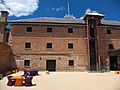
Early on, there was a strike among the soldiers guarding the convicts. They felt there weren't enough of them to control the large number of convicts. An agreement was made to increase the number of soldiers. While some convicts were kept in Hobart Town's jail, other sites like Sarah Island and Port Arthur were created for stricter confinement of repeat offenders.
By 1817, more female convicts were arriving in Hobart Town. There wasn't enough space in the first jail. In 1821, permission was given to build a separate jail for women. It took nearly eight years to build. In December 1828, the first female convicts moved to the Cascades Female Factory.

New penal settlements opened at Maria Island (1825) and Port Arthur (1832). This made the island's East Coast more important. Richmond Gaol opened in 1825, and the Richmond Bridge, Australia's oldest surviving bridge, was built in 1823.

Port Arthur, though now known as a harsh prison, was advanced for its time. Improvements were made with the "model prison" in 1853, based on London's Pentonville prison. Conditions were fair, and efforts were made to reform men. Boys were taught trades and given religious lessons. Port Arthur was guarded by soldiers and dogs.
In 1831, the Campbell Street Gaol opened in Hobart Town. It had a beautiful Penitentiary Chapel and an execution yard. Law Courts were added and used until 1983. The jail had underground passages and solitary confinement cells.
Most convicts in Hobart were not kept in jails. They worked on government projects, like the Sorell Causeway, or as servants for free settlers. Some still caused trouble and were punished with heavy leg irons or flogging.
Convict transportation to Van Diemen's Land lasted 50 years. In the 1840s, a group in Hobart Town called the Anti-Transportation League pushed for it to end. By 1853, transportation was abolished. This led to calls for self-government, which was granted in 1856. Hobart Town remained the capital.
Hobart's Early Years (Early 1800s)
The first ten years of the settlement on the Derwent River were tough. Being so far away, even from Sydney, made people feel down. Settlers struggled with the new environment. Summers were hot, and winters were cold, almost like England.
The settlement faced many problems. The workforce was mostly unskilled convicts and unwilling soldiers. Supplies were often insufficient, and authorities neglected them. Disease was common, and there was a constant threat from Aboriginal attacks. The land was difficult, and there weren't enough tools. Building permanent homes was slow because of the thick forests.
Lieutenant Bowen's first settlement at Risdon Cove was poorly chosen. It was picked during a wet winter when the creek was full. But after a long, dry summer, the creek dried up, and the land became parched. Launching ships was hard due to tides, and the soil was bad for farming. Mosquitoes and flies were a big problem. Wildfires also became frequent.
By the time Captain David Collins arrived in February 1804, the soldiers were almost rebelling. They were tired of poor food and forced labor. Collins decided to move the settlement. Surveyor George Harris found a good sheltered cove at the mouth of a fast-flowing stream. This stream was fed by melted snow from Table Mountain (now Mount Wellington). This spot offered plenty of drinking water and protected ships.
Most tents were moved to Sullivans Cove on February 20, 1804. The colony's chaplain, Reverend Robert Knopwood, held the first church service there on February 26, 1804.
Before Risdon Cove was fully abandoned, a violent conflict happened between British forces and Indigenous Australians. On May 3, 1804, a group of about 300 Aboriginal people, looking for kangaroos, came over the hills above Risdon Cove. Both the soldiers and the hunting party were surprised. It seems the soldiers, feeling threatened, fired on the Aboriginal people. Between three and fifty Aboriginal people were reportedly killed. This event marked the start of bad relations between the British and the indigenous people. This led to many bloody encounters and the Black War.
Within two days of landing at Sullivans Cove, tents were set up for everyone. Building permanent shelters was a priority, but it was slow. Getting timber from the thick forests was harder than expected due to a lack of tools. A wharf was built by the fourth day to unload supplies. A storehouse was also built on Hunter Island, which could be reached at low tide.
By July, the Risdon Cove settlement was abandoned. Many of Bowen's original party returned to Sydney. The winter of 1804 was very wet, making conditions unpleasant. Many suffered from cold and disease.
The Hobart Town colony struggled to survive at first. Supply ships didn't arrive in the first year. A lack of wheat farming, bad droughts, and high temperatures in 1805 and 1806 almost ended the colony. Everyone was put on short food rations.
By early 1806, whaling began in the Derwent River. But by October 1806, conditions were still bad. Reverend Robert Knopwood wrote in his diary about the "distress of the colony." He noted the dry weather and how grubs destroyed vegetables. On Christmas Day, it was so hot that his thermometer broke.
Supplies from Sydney were cut off in 1806 due to floods. Hobart's wheat crop also failed due to drought. Settlers turned to fishing and even gathering seaweed to eat. They survived by using farm animals sent on early supply ships, like cattle, sheep, and pigs. They had more animals than equipment.

As the area was explored, places like the Coal River Valley were found to be good for farming. They soon produced large harvests. Unlike Sydney, where farming was hard, Hobart Town's crops in 1806 and 1807 were very successful.
The colony soon became stable. Local food production replaced the need for outside supplies. The climate was good for fruit orchards, especially apples and pears, and for raising livestock. The best resource was the sea. The Derwent River has one of the best deep-water harbours in the world, with plenty of marine life. Whaling and sealing became important industries, providing the economic base for Hobart Town in its early years.
The first overland journey across the island happened in February 1807. Lieutenant Thomas Laycock led soldiers from Port Dalrymple (later Launceston) in the north to Hobart Town in the south. They sought supplies for the struggling northern colony. Their journey took nine days. Their return trip followed a flatter route, which is now the Midlands Highway. A road between the two settlements was established by 1808.
Despite this, exploring and building roads into the interior was slow. Hobart Town mainly used sea routes for transport. By 1808, docks were built using convict labor. Important buildings like the government store were also built. The Commissariat's Store, completed in 1810, is Hobart's oldest surviving building. The Bond Store, finished in 1824, also still stands.
At first, most arrivals were convicts and soldiers. But soon, rumors of Van Diemen's Land attracted free settlers, helping Hobart Town grow. However, its isolation also drew people trying to escape the law or seeking a solitary life.
The 1810s saw Hobart Town grow from a pioneer camp into a town. Governor Lachlan Macquarie visited in 1811. He was disappointed by the poor state of defense and disorganization. He described the town as "untidy."
Macquarie planned to widen streets and build new roads in an organized way. He divided Hobart Town into a main square and seven streets, including Macquarie, Elizabeth, and Collins. He ordered buildings to be properly built or repaired, and planned a new church and courthouse. He also located major public places like a hospital and barracks. His plans still shape modern Hobart. In 1811, he decided that the northern settlement would be managed from Hobart Town. By 1813, Thomas Davey became the first Lieutenant-Governor for both North and South Van Diemen's Land.
Macquarie ordered the construction of the Bond Store, completed in 1815. He also commissioned Anglesea Barracks, which opened in 1814. It is now Australia's oldest continuously used barracks. By 1818, the Mulgrave Battery was built, giving Hobart Town two basic forts.
By 1814, several farms were outside the main settlement. These were mostly land grants given to hard-working free settlers or convicts who had finished their sentences. These grants were in areas that are now Hobart suburbs like Battery Point and Sandy Bay.
By 1820, Hobart Town had over 10,000 people. It became an important base for the Royal Navy in the Pacific. The island's natural resources, like timber, were useful for the Navy. Hobart became a busy port, shipping materials and rum. It was a vital stop for international shipping and trade, bringing wealth to the port. In 1823, the Van Diemen's Land Bank, the first in the colony, opened.
In the 20 years after settlement, Hobart Town became a center for whaling and sealing. Hobart's shipyards built and repaired many whaling ships. Whale oil became a major export, used to light London's street lamps. The wool industry also became a major export. By 1818, there were 12,000 cattle and 20,000 sheep. Merino sheep farms grew in the Midlands. Van Diemen's Land became known for its fine wool. Wheat crops were so plentiful that they were exported to Sydney. The Van Diemen's Land Company was formed in 1825 to raise sheep for British cloth makers.
The Van Diemen's Land Company was not popular in Hobart Town. Settlers worried it would use all the convict labor. The company tried to grow wheat and barley, but heavy rain often ruined crops. It faced financial trouble in the 1850s. However, the company successfully grew potatoes, oats, peas, and hay.
Education and religion became more important. In 1828, there were eight government primary schools. By 1835, that number grew to 29. Secondary education remained private. Libraries came early to Hobart Town. A reading room opened in 1822, and the Hobart Town Book Society in 1826. The Tasmanian Public Library opened in 1870.
Hobart in the Mid-1800s
By 1830, most of the fertile land on the island was settled. Until 1831, the governor had great power over land grants and convict labor. After 1831, land was sold by auction. This attracted "gentry farmers" who knew more about farming and had more money. Many became successful sheep farmers, benefiting from the Australian wool booms of the 1820s and 30s.
After focusing on settling the island and establishing basic industries, industrial development began to expand. It was found that Tasmania's climate was excellent for growing fruit. Apple orchards were planted in the Huon Valley in the 1840s, and many still operate today. Hops for beer were first grown in Hobart Town in 1806. Robert Clarke became the first beer brewer in the colony.
Many small breweries started. Large-scale operations began in 1824 when Charles Degreaves established the Cascade Brewery near Mount Wellington. The brewery expanded and is still operating today, making it Australia's longest continually running brewery.
This was also a key time for whaling and shipbuilding in Hobart Town. The waterfront was upgraded in the 1830s for more ships. The area north of the town, now called the Kings Domain (later Queen's Domain), was set aside as a public space in the early 1820s.
Van Diemen's Land became a separate colony from New South Wales in 1824. By 1825, Hobart Town was chosen as the new capital. An Executive Council, a Legislative Council, and the Supreme Court of Tasmania were established in Hobart Town. The Supreme Court Building was built in 1824.
Governor Arthur planned a Botanical Gardens on the domain, which opened in 1828. He also planned a grand new Government House, opened in 1829. A convict-built brick wall was added, heated inside to grow exotic plants. A second, 280-meter wall was added later, becoming Australia's longest surviving convict-built wall.

By 1830, Hobart Town's population was over 20,000. It had become a charming and busy southern ocean port. Whaling, sealing, wool, and wattle oil industries were thriving, as were farming crops like wheat and apples. The economy was strong, and life was comfortable for merchants and free residents.
Some early settlers who arrived with little became very wealthy. Henry Hopkins, for example, arrived in 1822. He made a large profit selling boots and invested in wool for export. After ten years, he was rich enough to build "Westella House," then the biggest house in Hobart Town, which still stands today. It had 48 rooms and a dining room for 60 guests.
Hopkins was important in early Van Diemen's Land history. He became a community leader and magistrate. He strongly campaigned to end convict transportation. He helped found congregationalism in Hobart Town and built a chapel. He also helped fund St. David's Anglican Cathedral and other churches.
As Hobart Town became more successful, the number of convicts sent from England increased in the late 1820s and 1830s. The Campbell Street Gaol opened in 1831, with its beautiful penitentiary chapel designed by John Lee Archer. This chapel is a fine example of colonial Georgian architecture. Two more wings were added in 1860, which became Criminal Courts used until 1985.
Charles Darwin visited Hobart Town on February 5, 1836, during the HMS Beagle expedition. He wrote about Hobart Town and the Derwent estuary, noting the "luxuriant" fields of corn and potatoes. He said he would prefer to live there if he had to move.

Hobart Town became dependent on outside trade. While many industries were successful, they weren't large enough for lasting wealth. By the 1830s, sealing declined, and whaling lessened. But Tasmanian wool exports continued to thrive. New industries were needed, and shipbuilding became a success in the 1830s. Tasmania's hardwood timber, excellent port facilities, and access to shipping routes meant that by 1850, Hobart Town built more wooden ships than all other Australian ports combined.
However, the world changed faster than Hobart. As Hobart Town dominated shipbuilding, a labor shortage hit the industry. Many men moved to the Victorian goldfields. Also, the shift to steam and steel ships hurt Hobart's wooden shipbuilding.
Hobart Town had a reputation as a rowdy town. The area north of the docks, called 'Wapping', was full of crowded houses, pubs, hotels, and gambling places for sailors. Cock-fighting and dog fighting were popular. The Theatre Royal, built in 1834, is in this area. Wapping was seen as the entertainment district.

Outside Wapping, the town grew well. Many grand sandstone buildings and colonial homes were built. While Wapping remained a crowded area, wealthier residents moved south to Battery Point and Sandy Bay. Battery Point, once farmland, became a collection of cottages and fine homes by the mid-1830s. It was dominated by the battery of guns it was named after. In 1839, 'Kelly's Steps' were built by Captain James Kelly. These steps provided a shortcut from Battery Point to the warehouses and dockyards of Salamanca Place.
In 1835, John Lee Archer designed the sandstone Customs House facing Sullivans Cove, completed in 1840. This building later became Tasmania's parliament house. A pub named after the Customs House (built 1844) is now popular with yachtsmen after the Sydney to Hobart yacht race.
Many beautiful churches were built. Scot's Church was built from 1834–36. The Salamanca Place warehouses and the Theatre Royal were also built then. St George's Anglican Church in Battery Point was completed in 1838. St Joseph's was built in 1840.
Sir John Franklin arrived in Hobart Town on January 5, 1837, with his wife Lady Jane Franklin. He became the 5th Lieutenant-Governor. The colony was focused on business but lacked culture and education. Lady Jane was eager to improve the town. However, their liberal views were not always popular.
Despite this, the Franklins did much to improve Hobart Town. Lady Jane Franklin ordered a replica Greek Temple built in Lenah Valley, which opened in 1841. Inside, she housed the Lady Jane Franklin Museum with replicas of the Elgin Marbles. The Franklins started the Royal Hobart Regatta in 1838, a popular annual event. They also founded Christ College, now part of the University of Tasmania, the city's first higher education institution.
Lieutenant-Governor Franklin opened the Tasmanian Museum and Art Gallery in October 1843. In 1844, he founded the Royal Society of Tasmania, the first Royal Society outside the United Kingdom. The Franklins' leadership brought much social and cultural improvement. Hobart Town became a city in 1842. It had grown from a defensive outpost to a penal settlement, and then to a successful trading port. Free settlers were outnumbering convicts, and people wanted an end to transportation and more self-rule.
By the mid-1800s, elegant sandstone buildings replaced the early mud and timber structures. Many grand colonial mansions were built by successful citizens. Many fine cottages from this period also survive. Hobart Town's main streets were lit by oil lamps from the 1840s, and by gas lamps in 1857.
Hobart in the Late 1800s
.JPG)
By the mid-1800s, Hobart Town was a busy port. Local businesses were thriving. The docks struggled with demand as the town's population neared 60,000. New docks and sandstone warehouses were built in an area called 'Cottage Green'. This area became known as the New Wharf, with access via Salamanca Place, named after the Battle of Salamanca. Many original warehouses still stand, now used as galleries, cafes, and restaurants.
Hobart's first major problems came with an economic downturn in the 1840s, followed by the Victorian gold rush in the early 1850s. Many people moved to the goldfields, causing a labor shortage and economic decline in Hobart. Despite this, the 1850s brought social and cultural progress. Convict transportation ended in 1853. Van Diemen's Land became an independent British Colony in 1856 and changed its name to Tasmania to distance itself from its convict past.
Hobart Town was declared the capital. The Customs House at Sullivans Cove was renovated to become the Parliament House. In 1858, the elegant Tudor-Gothic style Government House was completed. By 1866, a magnificent Italian Renaissance style Town Hall was finished. As the colony grew, more administrative buildings were needed, like the Treasury Offices (1859–1864) and a Registry of Deeds Office (1884).

Not only administrative needs were met, but also spiritual ones. Construction on a Catholic Cathedral began in 1860. In 1866, St Mary's Catholic Cathedral opened. The magnificent St David's Anglican Cathedral was completed in 1868.
By the late 1800s, the central waterfront area of Wapping declined due to efforts to control gambling and excessive drinking. Battery Point and Sandy Bay became home to wealthier residents. Wapping's shanties were torn down for new developments, like the wool store, which is now the Old Woolstore Hotel. Part of the area was used for the Hobart Gas Works, opened in 1857, bringing gas lighting to the streets.

In 1870, the 48-meter high Shot Tower was built by Joseph Moir at Taroona, south of Hobart. It was used to make shot for the Tasmanian Colonial Forces by dropping molten lead from the top.
The Hobart Electric Tramway Company started in 1893, providing Hobart with the first complete electric tramway in the Southern Hemisphere. The tramway was very popular and expanded rapidly. By the early 1900s, tramlines ran to many suburbs. The Hobart City Council took over in 1912. Electric trolley buses were introduced in 1935.
An economic depression hit Hobart in the early 1890s. But some companies succeeded. In 1891, Henry Jones started a jam factory using local fruit. His company, Henry Jones IXL, soon exported jam throughout the British Empire.
In 1895, American writer Mark Twain visited Hobart and wrote about it in his book Following the Equator. He described the region as beautiful but noted its dark past with convicts and conflicts.
Hobart in the Early 1900s
Hobart was badly affected by the 1890s depression. The population dropped, and the economy struggled. The early 1900s saw a shift from farming to industry. Henry Jones IXL built a grand new factory in 1911, the first reinforced concrete building in Australia. Several new buildings changed Hobart's skyline. In 1911, the grand new Hobart City Hall opened.

A new Customs House opened in 1902. The iconic sandstone Hobart General Post Office, with its classical clock-tower, opened on September 2, 1905. It was built with funds donated by the people to celebrate Australian Federation. A telephone exchange was added in 1907. The Hobart GPO is famous because Roald Amundsen telegraphed the news from there on March 7, 1912, that he had reached the South Pole.
While many bushfires had occurred around Hobart, few caused serious damage until the summer of 1913–14. Several small bushfires on Mount Wellington destroyed orchards, buildings, and livestock.
With the economy lagging, Premier Walter Lee visited Germany. He was inspired by their hydro-electricity schemes. He realized cheap electricity could help Tasmania. In 1914, the state government created the Hydro-Electric Department to provide cheap electricity and attract industry.
Upriver from the city, key industries were established, including the Pasminco Electrolytic Zinc Company, Cadbury's Chocolate Factory (1920), and the Boyer Newsprint Mills. Since the early 1900s, cheap hydro-electric power has helped Hobart maintain a small industrial base. However, it never attracted the heavy industry politicians hoped for, making Hobart the least industrialized Australian capital city.
The Cadbury Chocolate Factory project followed the company's Quaker principles of improving workers' lives. Architects designed the Cadbury Estate next to the factory, providing comfortable housing, shops, and recreation for workers.
Hobart's local economy continued to rely on farming and fishing, and smaller industries like canneries, fruit processing, and furniture making. Craft industries like pottery and woodwork also continued.
The first radio broadcast in Tasmania was in Hobart on December 17, 1924. This was part of a government plan to develop radio broadcasting in each state capital. At first, only those who bought licenses could listen. By mid-1925, 526 people in Hobart had licenses. The first station, 7ZL, was later bought by the Australian Broadcasting Commission in 1932, bringing free broadcasting to Hobart.
This allowed Hobart listeners to hear news that the first Tasmanian-born Prime Minister, Joseph Lyons, had been appointed. By 1937, Hobart had a second station, 7ZR. The next year, listeners tuned in to hear Don Bradman score 144 in a match against Tasmanians. 7ZR is now part of the Radio National network as 936 ABC Hobart.
In the 1930s, Modern architecture became popular in Hobart. One example is the Sunray Flats (1938). The 1930s saw another building boom, cut short by World War II.
On February 9, 1934, Hobart was hit by bad bushfires, known as 'Black Friday'. Several homes were destroyed, and many animals died, but no people were killed.
On January 23, 1937, the first road to the summit of Mount Wellington was completed. Named 'Pinnacle Road', it cost £26,000 and allowed easy access to the summit, which offers spectacular views of Hobart.
Hobart in the Late 1900s
After World War II, Hobart was a thriving small city. But it was mostly on the western side of the Derwent River.
Plans for a bridge across the Derwent River were first made in 1832, but the river's width and depth made it difficult. A pontoon bridge solution was found, and in 1943, the Hobart Bridge opened, connecting the two sides for the first time. It had a lifting section for ships to pass through.
The Hobart Bridge encouraged homes to be built on the eastern side. But by the mid-1950s, so many people lived there that the bridge had huge traffic jams. Stormy weather also made the roadway dangerous, with waves sometimes sweeping over cars.
By the late 1950s, a larger bridge was needed. Construction on the concrete arch Tasman Bridge began in May 1960 and finished on August 18, 1964. It cost £7 million. The bridge originally had four lanes and greatly improved access to the eastern shore.
The 1950s brought more travel for Australians. Tourism increased in Tasmania. In the early 1950s, the state government invested £2,000,000 to build the 4700-ton Princess of Tasmania. Built in 1958, it was the first ferry that allowed tourists to drive their cars from Melbourne to Devonport. Despite the ferry's popularity, it was clear that air travel was the future. In 1956, Lanherne Airport (now Hobart International Airport) opened 20 kilometers east of Hobart, bringing more tourists.

Hobart's trams were most popular in the 1930s and 40s. But by 1960, more private cars and buses led to financial problems for both passenger trains and trams.
The end for the trams came on April 29, 1960. A tram was hit by a lorry and rolled backward down Elizabeth Street during rush hour. The conductor, Raymond Donoghue, bravely stayed at his post, warning motorists and trying to stop the tram. He was killed when the tram crashed, but he saved the lives of all passengers. He was awarded the George Cross for his heroism.
After the accident and economic issues, Hobart's trams were replaced by petrol-powered buses. Most trams were sold for scrap. In the early 2000s, there were calls to bring back a tram service, possibly for tourism along the waterfront.
1967 was a terrible year for Hobart. On February 7, 1967, high winds, a heat wave, and arson led to the worst urban bushfire in Hobart's history. The fires, known as 'Black Tuesday', swept down both sides of the Derwent River. They destroyed countless homes and property. 52 people died in the Hobart area alone.
Tourism continued to boom in the 1960s. Local hotelier Greg Farrell pushed the State government to allow Australia's first legal Casino.

The idea divided locals and politicians. A referendum was held in 1968, and with 58% approval, it passed. Construction began on the 17-story octagonal tower of the Wrest Point Hotel Casino. It opened in 1973, bringing another tourism boom with gamblers and celebrities.
Despite the tourism booms, Tasmania's isolation prevented foreign investment in industry. Hobart experienced short building booms followed by longer periods of stagnation, a cycle that continued into the 1990s.
On Sunday, January 5, 1975, a disaster struck Hobart. The ship MV Lake Illawarra collided with the Tasman Bridge. The ship hit two pylons, causing a 127-meter section of the bridge to collapse onto the ship. The Illawarra sank, killing seven crew members. Five motorists also died when they drove off the collapsed section into the river.
Many ferry services were launched to help commuters stranded by the disaster. Others had to travel 20 kilometers to a temporary bridge near Risdon Cove. While it isolated many workers, the disaster led to a boom in local businesses on the eastern shore, in places like Rosny Park.
The disaster led to the development of a second major bridge across the Derwent River. The $49 million Bowen Bridge opened on February 23, 1984. It was named after Lieutenant John Bowen, who established the first British settlement at Risdon Cove.

The Tasman Bridge was repaired, taking over two years and costing an additional $44 million. Safety features were added, and the bridge was expanded to five lanes. The fifth lane is a central reversible lane used for peak hour traffic.
One of Hobart's largest building projects was completed in 1987: the waterfront Hobart Sheraton Hotel (now the Grand Chancellor). Its construction was unpopular because it blocked views for some residents. The builders were also criticized for running out of sandstone-colored bricks and using a pinker shade. The hotel broke Wrest Point Hotel Casino's monopoly on luxury hotels.
The 1990s brought big changes to Hobart. A nationwide recession caused high unemployment. But a shift in politics followed the 1989 state election. There was strong opposition to building another paper pulp mill and growing support for the Tasmanian Greens party. In 1998, 6 houses and over 3,000 hectares of land in Hobart were destroyed by bushfires.
In the late 1990s, a partnership between the Hotel Grand Chancellor, the Australian government, and the Tasmanian Government created a permanent home for the Tasmanian Symphony Orchestra. The 1,100-seat Federation Concert Hall opened on September 4, 2002. Its design sparked controversy due to its polished brass exterior. The hall was part of a larger redevelopment of the Wapping area.
Hobart in the 21st Century

In the early 2000s, Hobart benefited from Tasmania's economic recovery. Unemployment dropped, and housing prices rose. Many people from other Australian states and overseas moved to Hobart for its affordable and high standard of living. Population growth, which had been slow, began to rise steadily again.
The city is home to a creative community that is connected to its local environment. However, the issue of logging in Tasmanian old-growth forests continues to divide opinions.
Hobart has a thriving arts community, and the Tasmanian Symphony Orchestra is world-renowned. The Hobart City Council supports the arts by offering an annual City of Hobart Art Prize and funding various cultural activities. They support the City of Hobart Eisteddfod Society, the Salamanca Arts Centre, the Tasmanian Museum and Art Gallery, the Tasmanian Symphony Orchestra, and the Theatre Royal.
In 2008, discussions began about redeveloping large parts of Hobart's waterfront, especially around Macquarie Point and the old railyards. This project could change Hobart's look. This area was once a major rail hub, and the old Hobart Railway Station (now part of the ABC studios) is nearby. Another possible use for the area is new buildings for the Royal Hobart Hospital.
How Has Hobart's Population Changed?
Hobart's population has grown slowly, usually slower than other state capitals. Its growth has often depended on economic factors. While there have been times when the population decreased, generally, it has risen steadily since settlement. In the early 2000s, Hobart's population began to increase strongly again.
Modern Tasmania is a diverse society with people from many different backgrounds. Hobart shows this more than any other region in the state.
More and more migrants come from Asia. But over 90% of people in Hobart have a European background. Of those, 37.5% are described as Anglo-Celtic Australians, meaning they have British and Irish ancestors. 31% are of English ancestry, 9% of Irish, and 7% of Scottish.
Since the end of World War II, migrants have also come from other parts of Europe. There are notable communities of Italians, Greeks, Poles, Dutch, and Germans. The largest non-European communities in Hobart are Chinese and Hmong.
| City of Hobart Population by year |
|
|---|---|
| 1803 | 433 |
| 1810 | 2,500 |
| 1824 | 5,000 |
| 1835 | 38,959 |
| 1842 | 57,420 |
| 1850 | |
| 1860 | |
| 1870 | |
| 1880 | |
| 1890 | |
| 1900 | |
| 1910 | |
| 1920 | |
| 1930 | |
| 1968 | 140,000 |
| 1976 | 164,400 |
| 1981 | 173,700 |
| 1986 | 182,100 |
| 1991 | 183,500 |
| 1996 | 195,800 |
| 2001 | 197,282 |
| 2006 | 205,566 |
| 2020 | (projected) |
Important Historical Places in Hobart
- Arthur Circus
- Cascade Brewery
- Hobart Cenotaph
- Hobart coastal defences
- Kelly's Steps
- Old Hobart Gaol
- Runnymede House
- Salamanca Place
- Shot Tower
- St David's Cathedral
- Parliament House, Hobart
- Theatre Royal
Images for kids
-
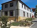
Commissariat Store
-
Bond Store
-

Hobart Gas Company
-
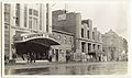
Elizabeth Street in 1920. Featuring Hobart's Palace Theatre, located opposite the Hobart GPO. Also pictured is the construction of a new building and the former Bank of Van Diemen's Land.


.jpg)
