
List of longest rivers of Canada facts for kids
Canada is a huge country, and it's home to some incredibly long rivers! These rivers are like giant watery highways that flow across the land, connecting different places and even crossing into other countries.
This article explores the longest rivers of Canada. We're talking about rivers that stretch for at least 600 kilometers (about 373 miles). Some rivers are measured by their main channel, called the main stem. Others are measured by adding the length of their main stem to one or more of their biggest connecting streams, called tributaries. We won't be looking at very short rivers that just connect lakes, or rivers that mostly flow outside of Canada, even if some of their smaller branches reach into Canada.
Many of these long rivers cross international borders or form them. For example, the Yukon River, Columbia River, Porcupine River, and Kootenay River all start in Canada and flow into the United States. On the other hand, the Milk River, Pend d'Oreille River, Saint Lawrence River, Red River, and Saint John River begin in the United States and flow into Canada. The Milk and Kootenay rivers are special because they cross the border twice! Even if a river stays entirely within Canada, its drainage basin (the area of land where all the water flows into that river) might extend into the United States. This is true for rivers like the Fraser River, Assiniboine River, and Saskatchewan River.
Canada's Longest Rivers: A Closer Look
The information in the table below comes mostly from The Atlas of Canada. The "discharge" means how much water flows out of the river at its end, unless noted otherwise. You'll see U.S. states written in italic letters.
Here's a quick guide to the symbols in the table:
| Key | |||||
|---|---|---|---|---|---|
| # | Name | Where it Ends | Length | Where it Starts | Watershed Area |
Water Flow (Discharge) |
Provinces, States |
Image |
|---|---|---|---|---|---|---|---|---|
| 1 | Mackenzie River | Beaufort Sea 69°21′59″N 133°54′10″W / 69.36639°N 133.90278°W |
4,241 km 2,635 mi |
Thutade Lake 56°44′00″N 127°31′00″W / 56.73333°N 127.51667°W |
1,805,200 km2 697,000 mi2 |
9,700 m3/s 340,000 ft3/s |
Northwest Territories |
 |
| 2 | Yukon River | Bering Sea 62°35′55″N 164°48′00″W / 62.59861°N 164.80000°W |
3,185 km 1,979 mi |
Teslin Lake 59°37′00″N 132°09′00″W / 59.61667°N 132.15000°W |
839,200 km2 324,000 mi2 |
6,340 m3/s 224,000 ft3/s |
British Columbia, Yukon, Alaska |
 |
| 3 | Saint Lawrence River | Gulf of Saint Lawrence 49°40′00″N 64°30′00″W / 49.66667°N 64.50000°W |
3,058 km 1,900 mi |
Seven Beaver Lake 47°30′04″N 91°49′51″W / 47.50111°N 91.83083°W |
1,344,200 km2 519,000 mi2 |
9,850 m3/s 348,000 ft3/s |
Minnesota, Wisconsin, Ontario, Michigan, Ohio, New York, Quebec |
 |
| 4 | Nelson River | Hudson Bay 57°04′05″N 92°30′08″W / 57.06806°N 92.50222°W |
2,575 km 1,600 mi |
Bow Glacier 51°40′00″N 116°27′00″W / 51.66667°N 116.45000°W |
892,300 km2 344,500 mi2 |
2,370 m3/s 84,000 ft3/s |
Manitoba |
 |
| 5 | Slave River | Great Slave Lake 61°18′00″N 113°40′04″W / 61.30000°N 113.66778°W |
2,338 km 1,453 mi |
Thutade Lake 56°44′00″N 127°31′00″W / 56.73333°N 127.51667°W |
616,400 km2 238,000 mi2 |
3,437 m3/s 121,400 ft3/s |
Alberta, Northwest Territories |
 |
| 6 | Columbia River | Pacific Ocean 46°14′39″N 124°03′29″W / 46.24417°N 124.05806°W |
2,000 km 1,243 mi |
Columbia Lake 50°09′53″N 115°50′19″W / 50.16472°N 115.83861°W |
671,300 km2 259,200 mi2 |
7,730 m3/s 273,000 ft3/s |
British Columbia, Washington, Oregon |
 |
| 7 | Saskatchewan River | Lake Winnipeg 53°11′20″N 99°15′18″W / 53.18889°N 99.25500°W |
1,939 km 1,205 mi |
Bow Glacier 51°40′00″N 116°27′00″W / 51.66667°N 116.45000°W |
335,900 km2 129,700 mi2 |
700 m3/s 25,000 ft3/s |
Alberta, Saskatchewan, Manitoba |
 |
| 8 | Peace River | Slave River 59°00′01″N 111°24′47″W / 59.00028°N 111.41306°W |
1,923 km 1,195 mi |
Thutade Lake 56°44′00″N 127°31′00″W / 56.73333°N 127.51667°W |
302,500 km2 116,800 mi2 |
2,118 m3/s 74,800 ft3/s |
British Columbia, Alberta |
 |
| 9 | Churchill River (Hudson Bay) | Hudson Bay 58°47′45″N 94°12′15″W / 58.79583°N 94.20417°W |
1,609 km 1,000 mi |
Churchill Lake 55°49′02″N 108°22′52″W / 55.81722°N 108.38111°W |
281,300 km2 108,600 mi2 |
1,200 m3/s 42,000 ft3/s |
Alberta, Saskatchewan, Manitoba |
 |
| 10 | South Saskatchewan River | Saskatchewan River 53°15′00″N 105°05′02″W / 53.25000°N 105.08389°W |
1,392 km 865 mi |
Bow Glacier 51°40′00″N 116°27′00″W / 51.66667°N 116.45000°W |
146,100 km2 56,400 mi2 |
280 m3/s 9,900 ft3/s |
Alberta, Saskatchewan |
 |
| 11 | Fraser River | Strait of Georgia 49°07′00″N 123°10′59″W / 49.11667°N 123.18306°W |
1,375 km 854 mi |
Fraser Pass 52°32′01″N 118°19′39″W / 52.53361°N 118.32750°W |
233,100 km2 90,000 mi2 |
3,540 m3/s 125,000 ft3/s |
British Columbia |
 |
| 12 | North Saskatchewan River | Saskatchewan River 53°15′00″N 105°05′02″W / 53.25000°N 105.08389°W |
1,287 km 800 mi |
Saskatchewan Glacier 52°14′33″N 117°09′05″W / 52.24250°N 117.15139°W |
122,800 km2 47,400 mi2 |
245 m3/s 8,700 ft3/s |
Alberta, Saskatchewan |
 |
| 13 | Ottawa River | Saint Lawrence River 45°33′59″N 74°23′11″W / 45.56639°N 74.38639°W |
1,271 km 790 mi |
Laurentian Mountains 47°36′00″N 75°43′40″W / 47.60000°N 75.72778°W |
146,300 km2 56,500 mi2 |
1,950 m3/s 69,000 ft3/s |
Quebec, Ontario |
 |
| 14 | Athabasca River | Lake Athabasca 58°59′05″N 110°51′23″W / 58.98472°N 110.85639°W |
1,231 km 765 mi |
Columbia Icefield 52°11′14″N 117°28′27″W / 52.18722°N 117.47417°W |
95,300 km2 36,800 mi2 |
783 m3/s 27,700 ft3/s |
Alberta |
 |
| 15 | Liard River | MacKenzie River 61°50′55″N 121°18′35″W / 61.84861°N 121.30972°W |
1,115 km 693 mi |
Saint Cyr Range 61°11′08″N 131°45′36″W / 61.18556°N 131.76000°W |
277,100 km2 107,000 mi2 |
2,446 m3/s 86,400 ft3/s |
Yukon, British Columbia, Northwest Territories |
 |
| 16 | Assiniboine River | Red River 49°53′09″N 97°07′41″W / 49.88583°N 97.12806°W |
1,070 km 660 mi |
near Hazel Dell 52°15′53″N 103°08′48″W / 52.26472°N 103.14667°W |
182,000 km2 70,000 mi2 |
45 m3/s 1,600 ft3/s |
Saskatchewan, Manitoba |
 |
| 17 | Milk River | Missouri River 48°03′26″N 106°19′07″W / 48.05722°N 106.31861°W |
1,005 km 625 mi |
Blackfeet Indian Reservation 48°51′20″N 113°01′10″W / 48.85556°N 113.01944°W |
61,200 km2 23,600 mi2 |
18.9 m3/s 670 ft3/s |
Alberta, Montana |
|
| 18 | Albany River | James Bay 52°17′00″N 81°30′59″W / 52.28333°N 81.51639°W |
982 km 610 mi |
Cat Lake 51°45′00″N 91°53′00″W / 51.75000°N 91.88333°W |
135,200 km2 52,200 mi2 |
251 m3/s 8,900 ft3/s |
Ontario |
 |
| 19 | Severn River | Hudson Bay 56°03′22″N 87°34′36″W / 56.05611°N 87.57667°W |
982 km 610 mi |
Deer Lake 52°37′00″N 94°40′00″W / 52.61667°N 94.66667°W |
102,800 km2 39,700 mi2 |
645 m3/s 22,800 ft3/s |
Ontario | |
| 20 | Back River | Chantrey Inlet 67°16′00″N 95°15′00″W / 67.26667°N 95.25000°W |
974 km 605 mi |
near Aylmer Lake 64°25′00″N 108°27′00″W / 64.41667°N 108.45000°W |
106,500 km2 41,120 mi2 |
612 m3/s 21,600 ft3/s |
Northwest Territories, Nunavut |
.jpg) |
| 21 | Thelon River | Baker Lake 64°16′30″N 96°04′35″W / 64.27500°N 96.07639°W |
904 km 562 mi |
Lynx Lake 62°20′36″N 106°02′18″W / 62.34333°N 106.03833°W |
142,400 km2 55,000 mi2 |
840 m3/s 30,000 ft3/s |
Northwest Territories, Nunavut |
 |
| 22 | La Grande River | James Bay 53°50′03″N 79°03′20″W / 53.83417°N 79.05556°W |
893 km 555 mi |
Lac Nichicun 53°12′30″N 70°56′00″W / 53.20833°N 70.93333°W |
97,600 km2 37,700 mi2 |
1,690 m3/s 60,000 ft3/s |
Quebec |
 |
| 23 | Red River | Lake Winnipeg 50°23′47″N 96°48′39″W / 50.39639°N 96.81083°W |
890 km 545 mi |
Wahpeton and Breckinridge 46°15′52″N 96°35′55″W / 46.26444°N 96.59861°W |
287,500 km2 111,000 mi2 |
236 m3/s 8,300 ft3/s |
North Dakota, Minnesota, Manitoba |
 |
| 24 | Koksoak River | Ungava Bay 58°32′11″N 68°09′29″W / 58.53639°N 68.15806°W |
874 km 543 mi |
Lake Sevestre 52°32′23″N 68°01′15″W / 52.53972°N 68.02083°W |
133,400 km2 51,500 mi2 |
2,800 m3/s 99,000 ft3/s |
Quebec |
|
| 25 | Churchill River (Atlantic) | Lake Melville 53°20′58″N 60°10′39″W / 53.34944°N 60.17750°W |
856 km 532 mi |
Ashuanipi Lake 52°59′20″N 66°14′28″W / 52.98889°N 66.24111°W |
79,800 km2 30,800 mi2 |
1,580 m3/s 56,000 ft3/s |
Newfoundland and Labrador |
 |
| 26 | Coppermine River | Coronation Gulf 67°49′09″N 115°03′50″W / 67.81917°N 115.06389°W |
845 km 525 mi |
Lac de Gras 64°35′02″N 111°11′24″W / 64.58389°N 111.19000°W |
50,800 km2 19,600 mi2 |
262 m3/s 9,300 ft3/s |
Northwest Territories, Nunavut |
 |
| 27 | Dubawnt River | Thelon River 64°32′59″N 100°06′00″W / 64.54972°N 100.10000°W |
842 km 523 mi |
Abitau Lake 60°21′00″N 107°09′00″W / 60.35000°N 107.15000°W |
57,500 km2 22,200 mi2 |
366 m3/s 12,900 ft3/s |
Northwest Territories, Nunavut | |
| 28 | Winnipeg River | Lake Winnipeg 50°37′54″N 96°19′13″W / 50.63167°N 96.32028°W |
813 km 505 mi |
Trap Lake 49°12′42″N 90°26′58″W / 49.21167°N 90.44944°W |
135,800 km2 52,400 mi2 |
850 m3/s 30,000 ft3/s |
Ontario, Manitoba |
 |
| 29 | Kootenay River | Columbia River 49°19′0″N 117°39′0″W / 49.31667°N 117.65000°W |
780 km 485 mi |
Beaverfoot Range 51°03′21″N 116°21′55″W / 51.05583°N 116.36528°W |
50,300 km2 19,400 mi2 |
850 m3/s 30,000 ft3/s |
British Columbia, Montana, Idaho |
 |
| 30 | Nottaway River | James Bay 51°22′33″N 78°55′45″W / 51.37583°N 78.92917°W |
776 km 482 mi |
Lake Gilles 48°07′00″N 75°38′00″W / 48.11667°N 75.63333°W |
65,800 km2 25,400 mi2 |
1,190 m3/s 42000 ft3/s |
Quebec | |
| 31 | Rupert River | James Bay 51°29′35″N 78°45′01″W / 51.49306°N 78.75028°W |
763 km 474 mi |
north of Lake Mistassini 52°13′11″N 71°32′19″W / 52.21972°N 71.53861°W |
43,400 km2 16,800 mi2 |
900 m3/s 32,000 ft3/s |
Quebec |
 |
| 32 | Eastmain River | James Bay 52°14′30″N 78°33′38″W / 52.24167°N 78.56056°W |
756 km 470 mi |
Lac Bréhat 52°31′30″N 70°52′00″W / 52.52500°N 70.86667°W |
46,400 km2 17,900 mi2 |
930 m3/s 33,000 ft3/s |
Quebec |
 |
| 33 | Attawapiskat River | James Bay 52°57′12″N 82°17′43″W / 52.95333°N 82.29528°W |
748 km 465 mi |
Attawapiskat Lake 52°10′00″N 87°37′00″W / 52.16667°N 87.61667°W |
50,500 km2 19,500 mi2 |
263 m3/s 9,300 ft3/s |
Ontario | |
| 34 | Kazan River | Thelon River 64°02′30″N 95°29′04″W / 64.04167°N 95.48444°W |
732 km 455 mi |
Ennadai Lake 60°55′00″N 101°20′00″W / 60.91667°N 101.33333°W |
71,500 km2 27,600 mi2 |
540 m3/s 19,000 ft3/s |
Nunavut |
 |
| 35 | Red Deer River | South Saskatchewan River 50°58′05″N 110°00′00″W / 50.96806°N 110.00000°W |
724 km 450 mi |
Sawback Range 51°32′19″N 116°02′46″W / 51.53861°N 116.04611°W |
45,100 km2 17,400 mi2 |
70 m3/s 2,500 ft3/s |
Alberta |
 |
| 36 | Great Whale River | Hudson Bay 55°15′58″N 77°47′04″W / 55.26611°N 77.78444°W |
724 km 450 mi |
Lake Saint-Lusson 54°49′30″N 70°32′17″W / 54.82500°N 70.53806°W |
42,700 km2 16,500 mi2 |
680 m3/s 24,000 ft3/s |
Quebec |
 |
| 37 | Porcupine River | Yukon River 66°35′42″N 145°18′32″W / 66.59500°N 145.30889°W |
721 km 448 mi |
Ogilvie Mountains 66°32′10″N 138°22′16″W / 66.53611°N 138.37111°W |
117,900 km2 45,500 mi2 |
414 m3/s 14,600 ft3/s |
Yukon, Alaska |
 |
| 38 | Pend d'Oreille River | Columbia River 48°59′59″N 117°37′00″W / 48.99972°N 117.61667°W |
703 km 437 mi |
near Butte 46°04′32″N 112°27′56″W / 46.07556°N 112.46556°W |
66,900 km2 25,800 mi2 |
820 m3/s 29,000 ft3/s |
Idaho, Washington, British Columbia |
 |
| 39 | Hay River | Great Slave Lake 60°51′50″N 115°44′04″W / 60.86389°N 115.73444°W |
702 km 436 mi |
near Zama Lake 58°14′14″N 118°51′34″W / 58.23722°N 118.85944°W |
48,200 km2 18,600 mi2 |
113 m3/s 4,000 ft3/s |
Alberta, Northwest Territories |
 |
| 40 | Saguenay River | Saint Lawrence River 48°07′59″N 69°43′59″W / 48.13306°N 69.73306°W |
698 km 434 mi |
near Otish Mountains 52°16′17″N 70°48′38″W / 52.27139°N 70.81056°W |
88,000 km2 34,000 mi2 |
1,750 m3/s 62,000 ft3/s |
Quebec |
 |
| 41 | Anderson River | Beaufort Sea 69°43′00″N 129°00′09″W / 69.71667°N 129.00250°W |
692 km 430 mi |
northwest of Great Bear Lake 66°57′00″N 124°36′00″W / 66.95000°N 124.60000°W |
142 m3/s 5,000 ft3/s |
Northwest Territories | ||
| 42 | Peel River | Mackenzie River 67°41′49″N 134°31′58″W / 67.69694°N 134.53278°W |
684 km 425 mi |
Gill Lake 65°19′00″N 139°49′00″W / 65.31667°N 139.81667°W |
73,600 km2 28,400 mi2 |
103 m3/s 3,600 ft3/s |
Yukon, Northwest Territories |
.jpg) |
| 43 | Saint John River | Bay of Fundy 45°16′00″N 66°04′00″W / 45.26667°N 66.06667°W |
673 km 418 mi |
Somerset County 46°33′47″N 69°53′05″W / 46.56306°N 69.88472°W |
55,200 km2 21,300 mi2 |
1,130 m3/s 40,000 ft3/s |
Maine, New Brunswick |
 |
| 44 | Stewart River | Yukon River 63°17′30″N 139°24′42″W / 63.29167°N 139.41167°W |
644 km 400 mi |
Selwyn Mountains 64°06′35″N 131°42′25″W / 64.10972°N 131.70694°W |
51,000 km2 20,000 mi2 |
675 m3/s 23,800 ft3/s |
Yukon |
 |
| 45 | Horton River | Franklin Bay 69°56′00″N 126°48′09″W / 69.93333°N 126.80250°W |
618 km 384 mi |
Kitikmeot Region, Nunavut 67°51′00″N 120°33′00″W / 67.85000°N 120.55000°W |
26,680 km2 10,300 mi2 |
Nunavut, Northwest Territories |
 |
|
| 46 | English River | Winnipeg River 50°12′04″N 95°00′12″W / 50.20111°N 95.00333°W |
615 km 382 mi |
near Marmion Lake 49°06′00″N 91°16′00″W / 49.10000°N 91.26667°W |
52,300 km2 20,200 mi2 |
Ontario | ||
| 47 | Pelly River | Yukon River 62°46′46″N 137°20′13″W / 62.77944°N 137.33694°W |
608 km 378 mi |
Mackenzie Mountains 62°49′00″N 129°53′00″W / 62.81667°N 129.88333°W |
51,000 km2 20,000 mi2 |
410 m3/s 14,000 ft3/s |
Yukon |
 |
Images for kids
-
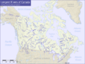
Rivers on this list shown on a map of Canada
-
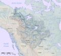
The Mackenzie River is the longest stream in Canada. It's measured from its mouth on the Beaufort Sea to the start of the Finlay River. The main part of the Mackenzie River is shown in dark blue.


See also
