
Marine navigation facts for kids

Marine navigation is the skill and science of guiding a ship from one place to another. It's about getting to your destination safely and efficiently. It's an art because it takes skill to avoid dangers. It's also a science because it uses knowledge from physics, math, oceanography, and astronomy.
Marine navigation can happen on the surface of the water or underwater, like with submarines.
Contents
The word "navigation" comes from the Latin word navigatio, which means "the act of sailing or voyaging." The word "nautical" also comes from Latin and Greek. It means anything related to sailing and the art of guiding a ship. "Naval" refers to ships and navigation, especially for a country's navy.
In Ancient Rome, people called navicularii were in charge of long-distance sea trade.
A Brief History of Sailing
People have been sailing along coasts for a very long time. Ancient stories, like the one about Noah's Ark, show that people in places like Mesopotamia (where the Tigris and Euphrates rivers are) used boats. The ancient Egyptians also sailed on the Nile River and in the Mediterranean Sea. They used sea routes that had been around since the Stone Age. These routes helped spread ideas and skills, like how to work with metals.
The people of Crete were very powerful at sea, ruling the seas until the Mycenaean period (around 2000 BC). Later, the Hittites fought the first recorded naval battle against Cyprus around 1210 BC. Around the same time, many civilizations in the eastern Mediterranean faced attacks from groups called the "Sea Peoples".
Early Ocean Explorers
The Phoenicians were known as great sailors in the Mediterranean. They were probably the first to sail far out into the high seas. They used the sun during the day and the North Star at night to guide them. They sailed through the Strait of Gibraltar into the Atlantic Ocean. They explored south along the coast of Africa and north to the British Isles. It's not clear if they sailed all the way around Africa or reached America. However, the Norsemen (Vikings) definitely reached North America around the 10th century.


.jpg)

.jpg)


.jpg)
-
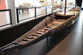
Remains of a 1st-century Gallo-Roman ship called Arles Rhône 3.
-
A Roman ship shown on a coin.
-
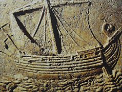
A carving on a 2nd-century sarcophagus showing a trading ship.
-
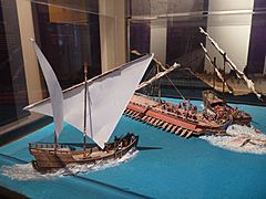
A model showing a naval fight between a Roman ship and Omani ships in the Indian Ocean, 2nd century.
.jpg)


Sailing the Oceans
In the Indian Ocean and Pacific Ocean, people sailed vast distances to settle islands like those in Polynesia. However, whether they reached South America is still debated. In the early 1400s, Chinese expeditions led by Zheng He reached the African coasts of the Indian Ocean. Some people suggest they might have sailed even further, but this is not widely accepted.

The Mediterranean Sea was controlled by the Romans for a long time. But in the Middle Ages, it became a battleground again. The Vandals attacked Italy from the sea. Later, the Byzantine Empire and then the Arabs gained control. Even the Vikings sailed there. During the Crusades, sailors from Venice, Genoa, and Aragon became very important.
The Age of Discovery
New inventions and knowledge made long ocean voyages possible. Europeans learned about the compass from the Arabs, who got it from the Chinese. Other tools like the astrolabe and sextant helped sailors find their position using stars. Better maps (like portulans) and new ship designs (like the caravel and galleon) also helped.
This led to the Age of Discovery, with Portugal and Spain leading the way. Prince Henry the Navigator helped start the Sagres school, which taught navigation. In 1492, Christopher Columbus made his first voyage to America. In 1488, Bartolomeu Dias sailed around the Cape of Good Hope, opening a sea route to the Indian Ocean. Vasco da Gama reached India in 1498.
Between 1519 and 1521, the Magellan-Elcano expedition sailed around the entire world. Spanish and Portuguese sailors were experts in navigation and mapping until the 16th century. Their knowledge helped European countries become very powerful around the world.
-
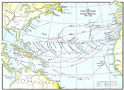
The four voyages of Columbus to America, 1492–1504.
-
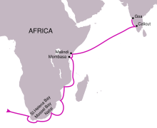
The route of Vasco de Gama's first voyage, 1498.
-
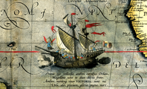
The Victoria, Magellan-Elcano expedition ship (1519-1521), in a map by Abraham Ortelius, 1590.
-
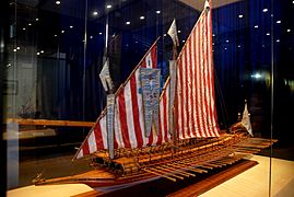
A model of the galley Real, the main ship of the Christian navy in the Battle of Lepanto (1571).
-
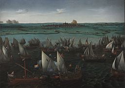
Dutch ships fighting the Spanish at the battle of Haarlemmermeer, 1573.
-
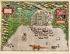
Francis Drake's fleet in front of Santo Domingo in 1585.
-
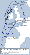
The route of the Spanish Armada, 1588.


-
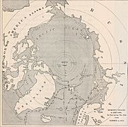
The navigation of Henry Hudson searching for the Northeast Passage, 1607–1608.
-
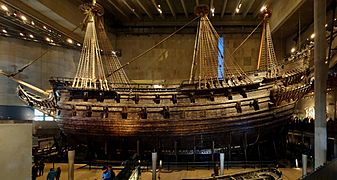
The Vasa, a Swedish navy ship that sank on its first trip, 1628.
_(14778654772).jpg)


From the 18th century, England became the leading naval power. This was confirmed after the Battle of Trafalgar in 1805. Famous English expeditions included those of Captain Cook (1768-1779) and the second voyage of the HMS Beagle (1831-1836). The Beagle's journey was very important for Charles Darwin's theory of evolution.
With the age of steam navigation, ships and techniques continued to improve. Fast sailing ships called clippers were still used for trade until the 20th century. The opening of the Panama Canal also changed shipping routes. However, a big shock to naval design happened with the sinking of the Titanic in 1912.
-
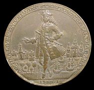
A medal used by the British navy to celebrate the capture of Cartagena de Indias, which did not happen (1741).
-
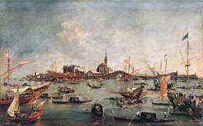
Venetian ships at a festival, painted by Francesco Guardi, around 1775.
-
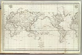
The expedition of Jean-François de La Perouse, 1785–1788.
-
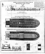
The layout of a slave ship for the slave trade in 1788.
-
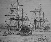
The Descubierta and Atrevida in the Philippines during the Malaspina expedition, 1789–1794.
-
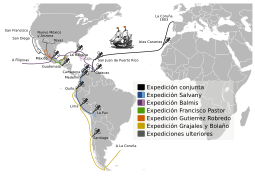
The voyages of the Royal Philanthropic Vaccine Expedition, 1803–1814.
-
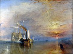
The Fighting Temeraire tugged to her last berth to be broken up, by J. M. W. Turner, 1838.
-
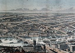
Busy navigation on the Thames in the mid-19th century.
-
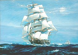
The "Ariel" and "Taeping" racing in the Great Tea Race of 1866.
-
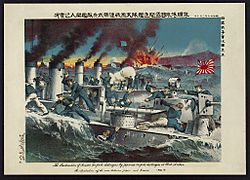
Naval fight between Russian and Japanese destroyers at Port Arthur during the Russo-Japanese War, 1904.
-
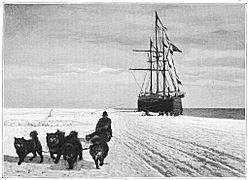
The Amundsen expedition to the South Pole, 1913.
-
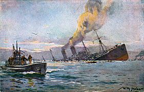
A German "U-boat" sinking an enemy ship in 1917.
-
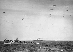
Operation Overlord (June 1944) was the largest naval operation in history.
-
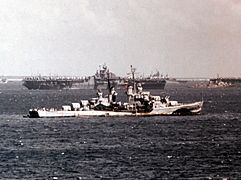
The United States Fifth Fleet leaving for Okinawa in March 1945.


-_D-day_6_June_1944_A24096.jpg)
_at_anchor_in_March_1945_(80-G-K-3813).jpg)
Today, most people travel by air instead of by sea. However, cruise ships are popular for leisure travel. Also, some people try to cross oceans illegally. Since the Second Industrial Revolution, most goods transported by sea are oil and gas in huge oil tankers. Other raw materials are carried in bulk on cargo ships. Since 1956, many goods are shipped in standardized containers. These containers make loading and unloading much faster. Modern navigation uses advanced technology, meaning fewer crew members are needed on very large ships.
-
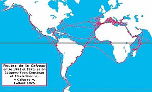
Routes of the Calypso, Commander Cousteau's research ship.
-
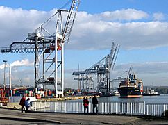
A cargo vessel using container cranes at the port of Le Havre.
-
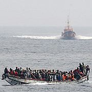
A boat overloaded with people, next to a Spanish coast guard vessel.


Sailors use different methods to solve three main problems:
- Finding the right direction (the "course").
- Knowing the "time," "speed," and "distance" for the trip.
- Knowing the "depth" of the water to avoid running aground.
This method involves finding the ship's position by looking at landmarks on the coast. These can be lighthouses, capes, or buoys. Sailors use tools like a pelorus (for visual bearings) or a sextant (for horizontal angles). They can also use electronic methods like radar to find their position.
Dead Reckoning
Dead reckoning is a way to estimate a ship's current position. It uses the last known position, the direction the ship has traveled, and its speed. Sailors also consider things that might have pushed the ship off course, like wind (called leeway) or ocean currents. The estimated position is called the "Dead reckoning location." It's also sometimes called a "Fantasy point."

This type of navigation follows a "rhumb line". A rhumb line crosses all lines of longitude at the same angle. On a nautical chart that uses the Mercator projection, a rhumb line looks like a straight line.
This method is good for shorter distances because it lets the ship keep a steady course. However, it doesn't always give you the shortest path between two points.
This method follows the shortest path between two points on the Earth. This path is called a "great circle". To figure out the direction and distance, sailors use a special kind of math called spherical trigonometry. This involves solving a triangle on a sphere, with the starting point, the destination, and one of the Earth's poles as the corners.


Celestial navigation is about finding a ship's position by observing stars and other celestial bodies. Sailors measure the angle of a star above the horizon using a sextant. They also need to know the exact time using a chronometer.
Here's the basic idea:
- Knowing the time and using a nautical calendar, sailors can find the star's position in the sky.
- If you know the star's position and how high it appeared above the horizon, you know you are somewhere on a circle around the point directly below that star.
- Every sailor on that circle would see the star at the same height. So, you know your ship is somewhere on that circle.
In the past, the math for this was complex. Sailors used tables and logarithms to help. With the invention of calculators and computers, it became easier. But now, with GPS, celestial navigation is mostly used as a backup or for fun.
Electronic navigation uses global positioning systems like GPS, GLONASS, or GALILEO. These systems use satellites to pinpoint a ship's location. It's the most common and easiest method to use today, even though it can sometimes have small errors.
Inertial navigation uses special sensors called accelerometers and gyroscopes on board the ship. These sensors measure how the ship moves and turns. Complex electronic systems then use this data to calculate the ship's speed and direction. From this, they can figure out the ship's exact location.
In ancient times, the dolphin was seen as a sign of a safe journey. Because of this, ships often had dolphin symbols.
More recently, navigation has been shown as a woman. She wears clothes that look like they are blowing in the wind. She might have a ship's stern (the back part) on her head. She holds a rudder in one hand and a tool for measuring height in the other. At her feet, you might see an hourglass, a compass, Neptune's trident, and symbols of trade. In the background, there's often the sea with a lighthouse and ships sailing.
See also
 In Spanish: Navegación marítima para niños
- World Cruising Routes
- Navigation
