Indo-Gangetic Plain facts for kids

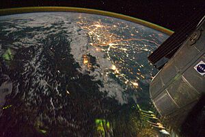
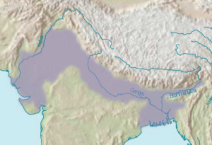
The Indo-Gangetic Plain, also called the North Indian River Plain, is a huge, fertile flatland. It covers about 700,000 square kilometers (270,000 square miles). This area includes most of northern and eastern India, much of eastern Pakistan, almost all of Bangladesh, and the southern plains of Nepal.
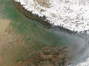
The plain gets its name from two important rivers: the Indus and the Ganges. Many big cities like Delhi, Dhaka, Kolkata, Lahore, and Karachi are found here. To the north, the plain is bordered by the mighty Himalayas. These mountains feed the plain's many rivers. The rivers bring rich, fertile soil called alluvium to the land. To the south, the plain meets the Deccan Plateau. To the west, the Iranian Plateau rises.
Contents
History of the Plain
This region is famous for the ancient Indus Valley civilization. This was one of the world's first great cultures. Because the land is flat and fertile, it was easy for many powerful empires to rise and grow here. These included the Maurya Empire, Kushan Empire, Gupta Empire, Mughal Empire, and Maratha Empire. Their main centers of power and population were always in the Indo-Gangetic Plain.
Ancient Names for the Region
During ancient times, this area was sometimes called "Aryavarta". This means "Land of the Aryans". An old text, the Manusmṛti, described Aryavarta as the land between the Himalayas and the Vindhya Range. It stretched from the Bay of Bengal in the east to the Arabian Sea in the west.
The region was also known as "Hindustan", or the "Land of the Hindus". The name 'Hindustan' comes from Persian. It means 'country of the Hindus or Indians'. The word Hindu comes from the Sanskrit word sindhu, meaning 'river'. The word stān means 'a place'. Later, 'Hindustan' was used to describe the entire Indian subcontinent. The term "Hindustani" also refers to the people, music, and culture of this area.
Rajput Kingdoms and Battles
In the 12th century, much of the Indo-Gangetic Plain was ruled by Rajputs. Important Rajput kingdoms included the Chauhans of Ajmer and the Gahadavals of Varanasi. The Rajput people also became a distinct group in Indian society around the time of the Ghurid invasions.
In 1191, the Rajput king Prithviraj Chauhan of Ajmer and Delhi united several Rajput states. He bravely defeated the invading army of Shihabuddin Ghori in the First Battle of Tarain.
However, Shihabuddin Ghori returned in 1192. Even though he had fewer soldiers, he strongly defeated Prithviraj's Rajput army in the Second Battle of Tarain. Prithviraj tried to escape but was captured and executed. This defeat was a major turning point in India's history. It weakened the Rajput power in the Indo-Gangetic Plain. It also firmly established Muslim rule in the region. After this battle, the Delhi Sultanate became very powerful. Muslim control spread across northern India within a generation.
Geography of the Plain
The Indo-Gangetic Plain is split into two main river systems by the Delhi Ridge. The western part flows into the Indus, while the eastern part flows into the Ganga and Brahmaputra rivers. This dividing ridge is only about 350 meters (1,150 feet) above sea level. This makes the plain seem like one continuous flat area from Sindh in the west to Bengal and Assam in the east.
Different Land Types
Near the foothills of the Himalayas, there is a narrow strip of land called the Bhabar. This area has porous ground with many boulders and pebbles washed down from the mountains. It's not good for farming and is mostly forested. Small streams often disappear underground here.
Below the Bhabar are the grasslands of Terai and Dooars.
The many smaller rivers that flow into the Indus and Ganga divide the plain into areas called doabs. These are strips of land between two rivers. Close to the rivers, there is khadar land. This is new, fertile soil that gets flooded often. Higher up, away from the floodwaters, is bangar land. This is older soil that was deposited a long time ago.
Rainfall and Rivers
The amount of rainfall increases as you move from west to east across the plain. The Lower Ganges Plains and the Assam Valley are greener than the middle Ganga plain. The lower Ganga flows through West Bengal and into Bangladesh. There, it joins the Jamuna (a branch of the Brahmaputra). Together, they form the huge Ganges Delta. The Brahmaputra River starts in Tibet as the Yarlung Zangbo River. It flows through Arunachal Pradesh and Assam before entering Bangladesh.
Regions of the Plain
Some experts divide the Indo-Gangetic Plain into several regions. These include Gujarat, Sindh, Punjab, Doab, Rohilkhand, Awadh, Bihar, Bengal, and the Assam regions.
Generally, the Indo-Gangetic Plain stretches across:
- The Jammu Plains in the north.
- The Punjab Plains in eastern Pakistan and northwestern India.
- The Sindh Plains in southern Pakistan.
- The Indus Delta in southern Pakistan and western India.
- The Ganga-Yamuna Doab.
- The Rohilkhand (Katehr) Plains.
- The Awadh Plains.
- The Purvanchal Plains.
- The Bihar Plains.
- The North Bengal plains.
- The Ganges Delta in India and Bangladesh.
- The Brahmaputra Valley in the east.
The fertile Terai region is found in Southern Nepal and Northern India. It lies along the foothills of the Himalayas. Important rivers in this area include the Beas, Chambal, Chenab, Ganga, Gomti, Indus, Ravi, Sutlej, and Yamuna. The soil is very rich in silt. This makes the plain one of the most intensely farmed areas in the world. Even rural areas here have many people living in them.
The Indus–Ganga plains are also known as the "Great Plains". They are huge floodplains created by the Indus, Ganga, and Brahmaputra river systems. They run next to the Himalaya mountains, from Jammu and Kashmir and Khyber Pakhtunkhwa in the west to Assam in the east. They drain most of Northern and Eastern India. The plains cover about 700,000 square kilometers (270,000 square miles). Their width changes along their length, sometimes by hundreds of kilometers. The main rivers are the Ganga and the Indus, along with their smaller rivers like the Beas, Yamuna, Gomti, Ravi, Chambal, Sutlej, and Chenab.
This area is the world's largest stretch of unbroken fertile soil. It was formed by silt deposited by many rivers. The plains are flat and mostly treeless. This makes them perfect for irrigation using canals. The area also has lots of underground water. These plains are the world's most intensely farmed areas. The main crops are rice and wheat, which are grown one after the other. Other crops include maize, sugarcane, and cotton. The Indo-Gangetic plains are among the most densely populated places on Earth, with over 400 million people.
Animals of the Plain
Not long ago, the open grasslands of the Indus-Ganga Plain were home to many large animals. These open plains were like the landscapes of modern Africa. They had huge numbers of plant-eating animals. This included all three types of Asian rhinoceros: the Indian rhinoceros, Javan rhinoceros, and Sumatran rhinoceros.
Large herds of Indian elephants, gazelles, antelopes, and horses lived here. There were also several types of wild cattle, including the now-extinct aurochs. In the forested areas, there were different kinds of wild pig, deer, and muntjac. In the wetter areas near the Ganga, large herds of water buffalo grazed along the riverbanks. There were also extinct types of hippopotamus.
So many large animals meant there were also many predators. Indian wolves, dholes, striped hyenas, Asiatic cheetahs, and Asiatic lions hunted large animals on the open plains. Bengal tigers and leopards hunted in the nearby woods. Sloth bears looked for termites in both areas. In the Ganges River, there were many gharials, mugger crocodiles, and river dolphins. They helped control fish populations and sometimes hunted animals crossing the river.
Farming in the Plain
Farming on the Indus-Ganga Plain mainly involves growing rice and wheat. Farmers often switch between these two crops. Other crops grown include maize, millets, barley, sugarcane, and cotton.
The main source of rain is the southwest monsoon. This rain is usually enough for general farming. The many rivers flowing from the Himalayas provide water for big irrigation projects.
Because the population is growing very fast, this area might face water shortages in the future. The plain includes the land between the Brahmaputra River and the Aravalli Range. The Ganga and other rivers like the Yamuna, Ghaghara, and Chambal River flow through this area.
Administrative Divisions
It's hard to draw exact borders for the Indo-Gangetic Plain. So, it's also hard to list every administrative area that is part of it.
However, here are the areas that are completely or mostly within the plain:
- Bangladesh (except the Chittagong Hill Tracts)
- Bhutan (only the southern edges bordering India)
- India
- Arunachal Pradesh (the southern edges bordering Assam)
- Assam (the Brahmaputra and Barak Valley)
- Bihar (almost entirely)
- Chandigarh
- Delhi (almost entirely)
- Haryana
- Himachal Pradesh (Una district and the southern edges bordering Punjab and Haryana)
- Jammu and Kashmir (the 3 southernmost districts of the Jammu Division)
- Madhya Pradesh (Gird Region including the Chambal division)
- Punjab
- Rajasthan (Sri Ganganagar and Hanumangarh districts)
- Uttarakhand (Terai Region including Haridwar and Udham Singh Nagar districts)
- Uttar Pradesh (except the Chitrakoot division)
- West Bengal (except the Darjeeling Himalayan hill region)
- Nepal
- Pakistan
- Balochistan (Kacchi Plains)
- Punjab (except Salt Range and Cholistan desert)
- Sindh (except the Kirthar Range and the Thar desert)
- Khyber Pakhtunkhwa (Derajat region and the Peshawar Valley)
See also
 In Spanish: Llanura indogangética para niños


