Dunedin facts for kids
Quick facts for kids
Dunedin
Ōtepoti (Māori)
|
|||
|---|---|---|---|
|
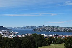
Cityscape seen from Signal Hill
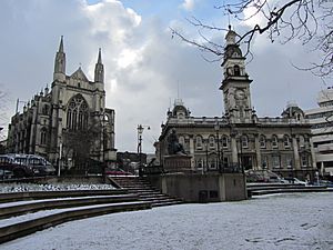
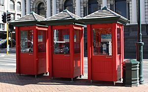
Princes Street
|
|||
|
|||
| Nicknames:
Edinburgh of the South;
Dunners (colloquial) |
|||
| Motto(s):
Maiorum Institutis Utendo
(By following in the Steps of our Forefathers) |
|||
| Country | New Zealand | ||
| Region | Otago | ||
| Communities |
|
||
| Settled by Māori | c. 1300 | ||
| Settled by Europeans | 1848 | ||
| Incorporated | 1855 | ||
| Named for | Dùn Èideann – Scottish Gaelic name for Edinburgh | ||
| NZ Parliament | Dunedin Taieri Te Tai Tonga (Māori) |
||
| Area | |||
| • Territorial | 3,286.14 km2 (1,268.79 sq mi) | ||
| • Urban | 91.16 km2 (35.20 sq mi) | ||
| Population
(June 2023)
|
|||
| • Territorial | 134,600 | ||
| • Density | 40.960/km2 (106.09/sq mi) | ||
| • Urban | 106,200 | ||
| • Urban density | 1,165.0/km2 (3,017.3/sq mi) | ||
| Demonym(s) | Dunedinite | ||
| Time zone | UTC+12:00 (NZST) | ||
| • Summer (DST) | UTC+13:00 (NZDT) | ||
| Postcodes |
9010, 9011, 9012, 9013, 9014, 9016, 9018, 9022, 9023, 9024, 9035, 9076, 9077, 9081, 9082, 9092
|
||
| Area code(s) | 03 | ||
| Local iwi | Ngāi Tahu | ||
| Website | DunedinNZ.com | ||
Dunedin (pronounced duh-NEE-din; Māori: Ōtepoti) is a major city in the South Island of New Zealand. It's the second largest city on the South Island, after Christchurch. Dunedin is the main city in the Otago region.
The city's name comes from Dùn Èideann, which is the Scottish Gaelic name for Edinburgh. Edinburgh is the capital city of Scotland. Dunedin has a rich history, with influences from Māori, Scottish, and Chinese cultures.
Dunedin is New Zealand's seventh-largest city area. It has a population of about 134,600 people. For a long time, Dunedin has been seen as one of New Zealand's four most important cities. The city is located on the central-eastern coast of Otago. It sits around the top of Otago Harbour. The harbour and the hills around Dunedin are actually what's left of an old volcano! The city's suburbs spread out into the nearby valleys and hills. They also reach onto the narrow strip of land of the Otago Peninsula.
People from the Māori tribe lived in the Dunedin area for a long time before Europeans arrived. The Otago region gets its name from the Ngāi Tahu village of Otakou. This village was at the mouth of the harbour and became a place for whaling in the 1830s.
In 1848, Scottish settlers arrived and created a new town. Between 1855 and 1900, many more Scottish people moved to Dunedin. The city grew very quickly and became wealthy during the Otago gold rush in the 1860s. For a short time, it was New Zealand's biggest city. Many Chinese people also moved to Dunedin during this period, mostly from Guangdong and Guangxi. Dunedin is home to New Zealand's oldest Chinese community.
Today, Dunedin has many different types of businesses. These include manufacturing, publishing, arts, tourism, and technology. A big part of the city's economy comes from universities and colleges. Many students attend the University of Otago, which is New Zealand's oldest university, and the Otago Polytechnic. These students make up a large part of Dunedin's population. In 2006, about 21.6% of the city's population was aged 15 to 24. This is much higher than the New Zealand average of 14.2%.
Dunedin is also famous for its exciting music scene. In the 1980s, it was the birthplace of the "Dunedin sound". This music style had a big impact on grunge, indie, and modern alternative rock. In 2014, UNESCO named Dunedin a City of Literature.
Contents
Discovering Dunedin's Past
Early Māori Life in Dunedin
Evidence from old sites shows that Māori first lived in New Zealand between 1250 and 1300 AD. They mostly lived along the southeast coast. A camp at Kaikai Beach, near Long Beach, dates back to this time.
Many ancient Māori sites, some quite large, are found in what is now Dunedin. These were often lived in all year round, especially in the 1300s. Later, the population changed, and new fortified settlements called pā were built. One important pā was Pukekura at Taiaroa Head, built around 1650. There was also a settlement in central Dunedin (Ōtepoti) until about 1785.
Māori stories tell of early people called Kahui Tipua living here. Then came Te Rapuwai, followed by Waitaha, Kāti Mamoe, and finally Kai Tahu in the mid-1600s. These movements of people were similar to European migrations.
European Settlers Arrive
Lieutenant James Cook sailed near Dunedin's coast in 1770. He named Cape Saunders and Saddle Hill. He saw penguins and seals, which brought sealers to the area in the early 1800s.
William Tucker was the first European to settle here in 1815. More permanent European settlement began in 1831. The Weller brothers started a whaling station at Otago, now Otakou, on the harbour. Sadly, diseases greatly reduced the Māori population. By the late 1830s, the harbour was a busy international whaling port. Johnny Jones started a farm and a mission station, the first in the South Island, at Waikouaiti in 1840.
In 1844, a ship called the Deborah arrived. On board was Frederick Tuckett from the New Zealand Company. He was looking for a good spot for a new Scottish settlement. After looking at many places, Tuckett chose the area that would become Dunedin. He thought the land near Christchurch was too swampy.
The Free Church of Scotland founded Dunedin in 1848. It was meant to be the main town of their special settlement. The name Dùn Èideann is the Scottish Gaelic name for Edinburgh, Scotland's capital.
Charles Kettle, the city's surveyor, designed Dunedin to be like Edinburgh. This led to some grand and unusual streets as builders tried to create his bold plan on the challenging land. Captain William Cargill, a soldier from the Napoleonic Wars, was the leader of the new colony. The Reverend Thomas Burns, a relative of the poet Robert Burns, guided the settlers spiritually.
The Gold Rush Boom
In 1852, Dunedin became the capital of the Otago Province. This province covered all of New Zealand south of the Waitaki. In 1861, gold was found at Gabriel's Gully nearby. This led to a huge number of people moving to Dunedin. By 1865, Dunedin became New Zealand's largest city because of this growth. Many new people came from Ireland, Italy, Lebanon, France, Germany, and China.
Dunedin quickly became an industrial city. The Main South Line railway connected the city to Christchurch in 1878 and Invercargill in 1879. Important schools like Otago Boys' High School (1863) and Otago Girls' High School (1871) were founded. The University of Otago, New Zealand's oldest university, opened in 1869.
From 1881 to 1957, Dunedin had cable trams. It was one of the first and last cities in the world to use them. In the early 1880s, the frozen meat industry began. The first shipment left from Port Chalmers in 1882. This started a major national industry.
After the gold rush, the economy slowed down. But a plan by Julius Vogel brought thousands more people, especially to Dunedin and Otago. Many important businesses and buildings were built during these prosperous times. New Zealand's first daily newspaper, art school, medical school, and public art gallery (the Dunedin Public Art Gallery) were all established here.
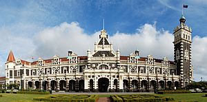
Many beautiful and grand buildings were constructed. R.A. Lawson designed the First Church of Otago and Knox Church. Other famous buildings include the Railway Station and Olveston.
Dunedin in the 20th Century
By 1900, Dunedin was no longer the biggest city in New Zealand. Other cities to the north grew more. But the university kept growing, and a student area developed. People started to appreciate Dunedin's older, grand buildings. Writers like E.H. McCormick noted its special charm.
In the 1930s and early 1940s, new artists like M.T. (Toss) Woollaston and Colin McCahon emerged. They were some of the country's best talents.
Many large companies started in Dunedin and became national leaders. These included Fletcher Construction, Kempthorne Prosser (a fertiliser and drug maker), G. Methven (a metalworking firm), and H. E. Shacklock (an appliance maker). Other well-known Dunedin companies were Mosgiel Woollens, Hallensteins (menswear), and department stores like the DIC and Arthur Barnett.
Modern Dunedin
After World War II, Dunedin's population and economy grew again. However, it was now the fourth largest city. Some older buildings were unfortunately torn down during this time. The university continued to grow, and the city became a hub for arts. Famous artists and writers like James K. Baxter and Janet Frame came to live here.
In the 1980s, Dunedin's popular music scene became very active. Bands like The Chills and The Clean became famous nationally and internationally. This style of music was called "The Dunedin Sound". Today, many bands and musicians still play and record in Dunedin.
By 1990, the city's population stopped shrinking and started to grow slowly. Dunedin became known as a "heritage city." Its main streets were updated to look like they did in Victorian times. The Dunedin Town Hall was beautifully restored. The city is also known for its excellent universities and research.
Dunedin continues to improve itself. The art gallery, railway station, and Toitū Otago Settlers Museum have all been redeveloped.
The city has a population of about 130,500 (June 2018) people.
Dunedin has many special industries. These include engineering, software, bio-technology, and fashion. Port Chalmers on the Otago Harbour is a deep-water port for Dunedin. It is connected by a railway line that goes from Christchurch through Dunedin to Invercargill.
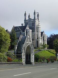
Dunedin is famous for its beautiful Victorian and Edwardian buildings. These show how wealthy the city was during the gold rush. Many, like First Church and Otago Boys' High School, were designed by the famous architect R A Lawson. Other important buildings include Olveston and the Dunedin Railway Station.
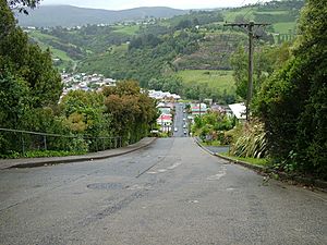
Other unique places are Baldwin Street, which is said to be the steepest residential street in the world. There's also the Cadbury Chocolate Factory (Cadbury World) and the local Speight's brewery.
Dunedin is also a great place for ecotourism. The world's only mainland royal albatross colony is here. You can also see penguins and seal colonies on the Otago Peninsula. To the south, you can visit the Sinclair Wetlands.
The large number of university students creates a lively youth culture. Students are sometimes called 'Scarfies'. This culture includes the music scene and a growing fashion industry. Dunedin also has a strong visual arts community, especially in Port Chalmers and other towns along the Otago Harbour.
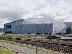
Dunedin has many sports facilities. These include Forsyth Barr Stadium for rugby and University Oval, Dunedin for cricket. There's also the new Caledonian Ground for football and athletics. The Edgar Centre is a large indoor sports centre. Dunedin Ice Stadium is for ice sports. There are also many golf courses and parks. St Clair Beach is a popular place for surfing. The harbour is great for windsurfers and kitesurfers. Dunedin has four public swimming pools.
Exploring Dunedin's Landscape
How Big is Dunedin City?
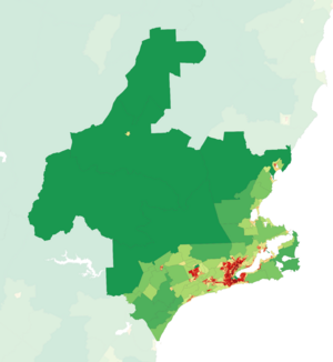
Dunedin City covers a land area of about 3,314.8 square kilometres. This is a bit larger than the American state of Rhode Island. It's also slightly smaller than Cornwall in England. Until 2010, Dunedin was the largest city in New Zealand by land area.
The city's boundaries have been set since 1989. They reach to Middlemarch in the west. To the north, they go to Waikouaiti. The Pacific Ocean is to the east and south-east. The Waipori/Taieri River and the town of Henley are in the south-west.
Dunedin is one of the farthest cities in the world from London. It is about 19,100 kilometres away. It is also about 18,200 kilometres from Berlin.
Dunedin is located at the top of Otago Harbour. This is a narrow inlet that stretches for about 24 kilometres. The harbour was formed when two river valleys flooded. Since it was founded in 1848, the city has slowly grown over the flat areas and nearby hills. It also spread across the narrow strip of land to the Otago Peninsula.
 |
Ranfurly and Alexandra | Oamaru and Timaru |  |
|
| Taieri Plains | ||||
| Invercargill and Balclutha | The Catlins |
Inside Dunedin City
The very centre of Dunedin is called the Octagon. This area used to be a gully, but it was filled in during the mid-1800s to create the plaza you see today. The first part of the city was built to the south, on the other side of Bell Hill. This large hill had to be made smaller to make it easier to get between the two parts of the settlement.
The central city runs mostly from northeast to southwest. The main streets, George Street and Princes Street, meet at The Octagon. Here, they are joined by Stuart Street. Stuart Street runs across them, from the Dunedin Railway Station in the southeast, and then steeply up to the suburb of Roslyn in the northwest. Many of the city's important old buildings are in the southern part of this area. They are also on the inner ring of lower hills around the city centre. Most of these hills, like Maori Hill, Pine Hill, and Maryhill, rise to about 200 metres above the flat land.
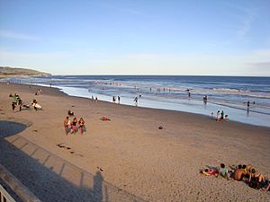
The top of the harbour includes a large area of land that was created by filling in water. This area is called "The Southern Endowment." Much of it is used for light industry and storage. A large flat area, known as "The Flat," is to the south and southwest of the city centre. It includes several older and larger suburbs, such as South Dunedin and St. Kilda. These areas are protected from the Pacific Ocean by a long line of sand dunes. These dunes run east-west along the city's southern coast. They separate the houses from Ocean Beach, which is divided into St. Clair Beach at the western end and St. Kilda Beach to the east.
Dunedin is home to Baldwin Street. The Guinness Book of Records says it is the steepest street in the world. Its slope is 1 in 2.9, which means for every 2.9 metres you walk horizontally, you go up 1 metre.
Beyond the inner hills are Dunedin's outer suburbs, especially to the northwest, past Roslyn. This area includes Taieri Road and Three Mile Hill. These formed the original road to the Taieri Plains. The modern State Highway 1 takes a different path, going through Caversham in the west and past Saddle Hill. Between Saddle Hill and Caversham are the outer suburbs of Green Island and Abbotsford. Between Green Island and Roslyn is the steep valley of the Kaikorai Stream. This area is now used for homes and light industry.
Suburban towns also lie along both sides of the Otago Harbour. Important ones include Portobello and Macandrew Bay on the Otago Peninsula coast. Port Chalmers is on the opposite side of the harbour. Port Chalmers is Dunedin's main deep-water port, including its container port.
Dunedin's skyline is dominated by a ring of hills. These hills are what is left of an old volcanic crater. Some of the notable hills are Mount Cargill (700 metres high), Flagstaff (680 metres high), Saddle Hill (480 metres high), Signal Hill (390 metres high), and Harbour Cone (320 metres high).
Beyond the City: Dunedin's Hinterland
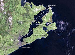
Dunedin's surrounding area has many different types of land. To the southwest are the Taieri Plains. These are wide, fertile lowlands formed by the Taieri River and its main branch, the Waipori. These plains are quite populated and include the towns of Mosgiel and Allanton. Low hills, about 300 metres high, separate them from the coast.
Inland from the Taieri Plain is rough, hilly country. Close to the plain, much of this land is covered in forests. This is especially true around Berwick and Lake Mahinerangi. It's also true around the Silverpeaks Range, which is northwest of Dunedin. Further inland, the land becomes drier and is covered in grass and tussock. A high, wide valley called the Strath-Taieri is in Dunedin's far northwest. It contains the town of Middlemarch, one of the few populated areas there.
To the north of the city is rolling hill country. It has several small towns, mostly along the coast. These include Waitati, Warrington, Seacliff, and Waikouaiti. State Highway 1 winds steeply through these hills, especially The Kilmog. These hills are like a coastal extension of the Silverpeaks Range.
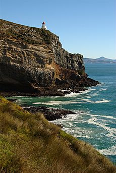
To the east, Dunedin City includes all of the Otago Peninsula. This is a long piece of land that was once the southeastern edge of the Dunedin Volcano. The peninsula is not very populated, mostly along the harbour coast. Much of it is kept as a natural home for animals by the Otago Peninsula Trust. The peninsula has several beautiful beaches. It is home to many rare species, such as yellow-eyed and little penguins, seals, and shags. Most importantly, it has the world's only mainland breeding colony of royal albatross. This colony is at Taiaroa Head on the peninsula's northeastern tip.
Dunedin's Climate
The weather in Dunedin is generally mild. However, the city has many different "microclimates." This means the weather can change a lot between different suburbs. This is mostly because of the city's hills and valleys. Dunedin has cool summers and mild winters, which is quite unique for its location.
Dunedin doesn't get as much rain as many other New Zealand cities. It only gets about 750 millimetres of rain each year. Even so, people sometimes think it's a damp city. This is probably because the rain often falls as light drizzle instead of heavy downpours. Dunedin is one of the cloudiest major cities in the country. It gets about 1650 hours of sunshine each year.
The main wind in the city is usually a cool southwesterly. In late spring, it can switch to northeasterlies. Warmer, dry northwest winds, called Foehn winds, also occur. The ring of hills around the city centre protects it from much of the strong weather. Hills just to the west of the city can also push bad weather around the city.
Inland, away from the city centre and into inland Otago, the climate is different. Winters are quite cold and dry, while summers are hot and dry. Thick, freezing fogs are common in winter in the upper parts of the Taieri River around Middlemarch. In summer, the temperature can sometimes reach 30 degrees Celsius.
| Climate data for Dunedin (1981–2010) | |||||||||||||
|---|---|---|---|---|---|---|---|---|---|---|---|---|---|
| Month | Jan | Feb | Mar | Apr | May | Jun | Jul | Aug | Sep | Oct | Nov | Dec | Year |
| Mean daily maximum °C (°F) | 18.9 (66.0) |
18.6 (65.5) |
17.3 (63.1) |
15.3 (59.5) |
12.7 (54.9) |
10.6 (51.1) |
10.0 (50.0) |
11.2 (52.2) |
13.2 (55.8) |
14.7 (58.5) |
16.1 (61.0) |
17.3 (63.1) |
14.6 (58.3) |
| Daily mean °C (°F) | 15.3 (59.5) |
15.0 (59.0) |
13.7 (56.7) |
11.7 (53.1) |
9.3 (48.7) |
7.3 (45.1) |
6.6 (43.9) |
7.7 (45.9) |
9.5 (49.1) |
10.9 (51.6) |
12.4 (54.3) |
13.9 (57.0) |
11.1 (52.0) |
| Mean daily minimum °C (°F) | 11.6 (52.9) |
11.5 (52.7) |
10.2 (50.4) |
8.2 (46.8) |
5.9 (42.6) |
4.0 (39.2) |
3.1 (37.6) |
4.2 (39.6) |
5.9 (42.6) |
7.2 (45.0) |
8.6 (47.5) |
10.4 (50.7) |
7.6 (45.7) |
| Average precipitation mm (inches) | 72.9 (2.87) |
67.8 (2.67) |
64.0 (2.52) |
50.9 (2.00) |
64.7 (2.55) |
57.9 (2.28) |
57.1 (2.25) |
55.7 (2.19) |
48.3 (1.90) |
61.7 (2.43) |
56.4 (2.22) |
80.2 (3.16) |
737.6 (29.04) |
| Average precipitation days (≥ 1.0 mm) | 9.7 | 8.5 | 8.9 | 8.3 | 9.8 | 9.4 | 9.3 | 9.6 | 8.7 | 10.1 | 10.0 | 12.0 | 114.2 |
| Average relative humidity (%) | 74.2 | 77.6 | 77.1 | 76.9 | 79.5 | 79.7 | 80.2 | 77.6 | 72.1 | 71.6 | 70.6 | 73.2 | 75.9 |
| Mean monthly sunshine hours | 179.6 | 158.0 | 146.1 | 125.9 | 108.4 | 95.3 | 110.6 | 122.2 | 136.8 | 165.5 | 166.9 | 168.3 | 1,683.7 |
| Source: NIWA Climate Data | |||||||||||||
People of Dunedin
Population and Demographics
The Dunedin City area has a population of about 134,600 people as of June 2023. This includes about 106,200 people in the main Dunedin urban area. It also includes people in Mosgiel (14,800), Brighton (1,540), and Waikouaiti (1,260). The rest live in smaller towns and rural areas.
| Historical population for the territorial area | ||
|---|---|---|
| Year | Pop. | ±% p.a. |
| 2006 | 118,683 | — |
| 2013 | 120,249 | +0.19% |
| 2018 | 126,255 | +0.98% |
| 2023 | 128,901 | +0.42% |
In the 2023 New Zealand census, Dunedin City had 128,901 people. This was an increase of 2,646 people since 2018. The median age was 37.0 years. About 14.8% of people were under 15 years old. About 26.7% were aged 15 to 29.
People could choose more than one ethnicity. The results showed that 85.1% were European (Pākehā). About 10.8% were Māori, and 9.3% were Asian. English was spoken by 97.6% of people.
When asked about religion, 27.6% identified as Christian. About 60.5% said they had no religion.
Of those aged 15 or older, 22.0% had a university degree or higher. The median income was $33,500. About 44.5% of people aged 15 or older worked full-time.
Dunedin's Culture and Arts
Dunedin as a City of Literature
In December 2014, Dunedin was named a UNESCO Creative City of Literature. This means the city is recognized worldwide for its strong literary heritage. Dunedin joined other famous literary cities like Edinburgh and Dublin.
Dunedin's application highlighted its rich history of writers, its many literary events, and its active community of authors. The city's website, www.cityofliterature.co.nz, shows off Dunedin's literary strengths.
UNESCO created the Creative Cities Network to help cities work together. They want to encourage cities to use culture for development. Dunedin is New Zealand's first city to join this network.
Music Scene in Dunedin
Choirs and Vocal Groups
Dunedin is home to many choirs.
- The City of Dunedin Choir has 140 members and performs large choral works.
- The Southern Consort of Voices is a smaller choir that also performs choral pieces.
- The Royal Dunedin Male Choir performs two concerts each year.
- The Dunedin RSA Choir performs regularly and plays a special role in ANZAC Day events.
- The all-female Dunedin Harmony Chorus is an important part of the city's culture.
- The Southern Children's Choir is the main children's choir in Dunedin.
- The Southern Youth Choir is a concert-based youth choir.
- The University of Otago has three official choirs, including the traveling Cantores choir.
- Many churches in Dunedin also have choirs, such as St. Joseph's Catholic Cathedral and Knox Church.
- The Dunedin Red Cross Choir is one of only three Red Cross choirs in the world.
Instrumental Music
The Dunedin Symphony Orchestra is a semi-professional orchestra based in the city. Other groups include the Rare Byrds early music ensemble and the Dunedin Youth Orchestra. Many schools also have orchestras and bands.
Dunedin also has three brass bands: St. Kilda Brass, Kaikorai Brass, and Mosgiel Brass. The Otago Symphonic Band and City of Dunedin Pipe Band are also important musical groups.
Popular Music and the Dunedin Sound
Dunedin is famous for the "Dunedin sound." This was a type of indie rock music that started in the city in the 1980s. Many Dunedin bands recorded with the Flying Nun Records label. Bands like The Chills, The Clean, and The Verlaines became well-known in New Zealand and overseas.
Dunedin continues to be a home for new music. Bands like Six60 and artists like Nadia Reid are from Dunedin.
Sports in Dunedin
Major Sports Teams
Dunedin is home to several professional sports teams:
- Highlanders – a Super Rugby rugby union team. They won the Super Rugby championship in 2015.
- Otago Rugby Football Union – a Mitre 10 Cup rugby union team.
- Otago Volts and Otago Sparks – men's and women's cricket teams.
- Southern Steel – a netball team.
- Southern United – an association football (soccer) team.
- Otago Nuggets and Southern Hoiho – men's and women's basketball teams.
- Dunedin Thunder – an ice hockey team.
- Otago Whalers – a Rugby League team.
Sports Grounds and Stadiums
Dunedin has many places for sports:
- Caledonian Ground
- Dunedin Ice Stadium
- The Edgar Centre (indoor sports)
- Forsyth Barr Stadium at University Plaza (rugby, football)
- Logan Park
- Moana Pool (swimming)
- University Oval (cricket)
Theatre and Performing Arts
The city has a large theatre, the Regent Theatre, located in the Octagon. Dunedin was home to the world's southernmost professional theatre company, the Fortune Theatre, until it closed in 2018.
Smaller theatres in Dunedin include the Globe Theatre, the Mayfair Theatre, and the Playhouse Theatre.
Visual Arts
Dunedin has a significant public art gallery, the Dunedin Public Art Gallery, also in the Octagon. There are many other galleries in the city, including over a dozen dealer galleries. Many of these are found along Princes Street, Moray Place, and Dowling Street. There are also more experimental art spaces, like the Blue Oyster.
Many famous artists have strong connections to Dunedin. These include Ralph Hotere, Frances Hodgkins, and Grahame Sydney.
Marae: Māori Meeting Places
Dunedin has three marae (Māori meeting grounds) for the Ngāi Tahu tribe. Each marae has its own wharenui (meeting house).
- Ārai-te-uru marae in Wakari has the Ārai-te-uru wharenui.
- Ōtākou Marae in Otakou has the Tamatea wharenui.
- Huirapa / Puketeraki marae in Karitāne has the Huirapa wharenui.
Special Recognition
An asteroid, 101461 Dunedin, was named after the city. It was discovered by astronomer Ian P. Griffin in 1998.
Media and Communication
News and Publications
The main daily newspaper in Dunedin is the Otago Daily Times. It is the oldest daily newspaper in New Zealand. Other local newspapers include The Star and Taieri Herald. The university also has its student magazine, Critic Te Ārohi.
Radio and Television
Dunedin receives all major national radio and television stations. The city's main TV and FM radio transmitter is on top of Mount Cargill. The main AM radio transmitter is at Highcliff on the Otago Peninsula.
Local radio stations include Radio Dunedin, Otago Access Radio, and the university station, Radio One.
Television broadcasts started in Dunedin on July 31, 1962, with channel DNTV2. In 1969, DNTV2 became part of the national NZBC TV network. Later, in 1975, the Dunedin studios became part of Television One (now TVNZ 1).
The city has a local television station called Channel 39. Major news broadcasters like 1News and Newshub also have offices in Dunedin.
Dunedin is home to several important media production companies. These include Natural History New Zealand and Taylormade Media.
Education in Dunedin
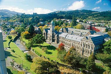
High Schools
Dunedin has 12 high schools. Eight are state schools, and four are state-integrated schools.
- The oldest high school is Otago Boys' High School, founded in 1863.
- Its sister school, Otago Girls' High School (1871), is the oldest state girls' high school in New Zealand.
- Other state schools include Bayfield High School, Kaikorai Valley College, and Logan Park High School.
- King's High School and Queen's High School are single-sex schools in St Clair.
- Taieri College is in Mosgiel.
- The four state-integrated schools are Columba College (Presbyterian girls' school), St. Hilda's Collegiate School (Anglican girls' school), John McGlashan College (Presbyterian boys' school), and Trinity Catholic College (Catholic co-educational school).
Universities and Colleges
- University of Otago
- Dunedin College of Education
- Otago Polytechnic
Getting Around Dunedin
Roads and Highways
Dunedin's main urban area is served by two state highways. Two more state highways and one tourist route serve other parts of the district.
- The main highway is State Highway 1. It runs north to south-west through the city. It connects Dunedin to Invercargill in the south and Timaru and Christchurch in the north.
- Between The Oval and Mosgiel, State Highway 1 uses the 11-kilometre Dunedin Southern Motorway.
- State Highway 88 connects central Dunedin to the port at Port Chalmers.
- State Highway 86 connects State Highway 1 at Allanton to Dunedin International Airport.
- State Highway 87 connects State Highway 1 at Kinmont to State Highway 85 at Kyeburn, going through Middlemarch.
- Dunedin is the start of the Southern Scenic Route. This is a tourist highway that connects Dunedin to Te Anau.
Bus Services
Buses in Dunedin are managed by the Otago Regional Council. There are 64 buses that run on 17 routes during weekdays. There are also 13 routes for evenings, weekends, and holidays. Two companies, Ritchies Transport and Go Bus Transport, operate the buses.
Rail Travel
Dunedin Railway Station, located east of the Octagon, is the city's main train station. It used to be the busiest station in the country. However, most train services have stopped over the years. Local train services ended in 1982. The last regular passenger train, The Southerner, stopped running in 2002.
The Taieri Gorge Railway now runs tourist trains from the station. The most popular is the Taieri Gorge Limited. It runs daily along the old Otago Central Railway through the beautiful Taieri Gorge. The Taieri Gorge Railway also goes to Palmerston once a week.
Air Travel
Dunedin International Airport is about 22 kilometres southwest of the city. It is located on the Taieri Plains at Momona. The airport has one terminal and a 1900-metre runway. It is the third-busiest airport in the South Island.
The airport is mainly used for flights within New Zealand. There are regular flights to and from Auckland, Christchurch, and Wellington. There are also charter flights to Queenstown, Wānaka, and Invercargill. International flights to and from Brisbane also operate year-round.
Sea Travel
A ferry service started in 2018 between Port Chalmers and Portobello. This is the first ferry service on this route since the early 1900s.
Annual Events in Dunedin
- January – Whare Flat Folk Festival ends
- February – New Zealand Masters Games (every two years)
- February – Otago University Students' Association & Otago Polytechnic Orientation Weeks
- February – Dunedin Summer Festival
- March – Dunedin Fringe Festival
- March/April – iD Dunedin Fashion Week
- May – Capping week (University of Otago) including the Capping Show
- May – International Rally of Otago
- May – Dunedin Writers & Readers Festival
- May – Regent Theatre 24-hour book sale (said to be the largest regular second-hand book sale in the Southern Hemisphere)
- June – Dunedin Midwinter Carnival
- June – St. Clair Polar Plunge
- July – University Reorientation
- July – New Zealand International Science Festival (every two years)
- July – Taste Otago Dunedin Food and Wine Festival
- July – Dunedin International Film Festival
- September – Dunedin City Marathon
- September – Dunedin Beer Festival
- October – Dunedin Arts Festival (every two years, even-numbered years)
- October – Rhododendron Week
- December – Samstock Music Festival
- December – Santa Parade
- December – Whare Flat Folk Festival begins
- December – New Year's Eve Party Octagon
Places to See in Dunedin
- Dunedin Railway Station
- Dunedin Town Hall
- Larnach Castle
- Cargill's Castle
- Olveston
- Speight's Brewery
- University of Otago Registry Building
- University of Otago Clocktower complex
- Regent Theatre
- The Octagon
- Orokonui Ecosanctuary
- Royal Albatross Centre
- St. Clair Beach
- Forsyth Barr Stadium
Museums, Art Galleries, and Libraries
- Otago Museum
- Toitū Otago Settlers Museum
- Dunedin Public Art Gallery
- Dunedin Public Libraries
- Hocken Collections
Churches to Visit
- All Saints' Church
- First Church
- Hanover Street Baptist Church
- Kaikorai Presbyterian Church
- Knox Church
- St. Joseph's Cathedral
- St Michael's Antiochian Orthodox Church
- St. Matthew's Church
- St. Paul's Cathedral
- Trinity Wesleyan Church – now the Fortune Theatre
Parks and Gardens
- Botanic Garden
- Dunedin Chinese Garden
- Woodhaugh Gardens
International Connections
Sister Cities
Dunedin has special connections with several cities around the world. These are called sister cities:
- Edinburgh, Scotland (since 1974)
- Otaru, Hokkaido, Japan (since 1980)
- Portsmouth, Virginia, United States of America (since 1962)
- Shanghai, China (since 1994)
See also
 In Spanish: Dunedin para niños


