
List of National Historic Landmarks in South Carolina facts for kids
South Carolina is home to many amazing places that are super important to American history! These special spots are called National Historic Landmarks (NHLs). The National Park Service helps protect and celebrate these landmarks. They can be buildings, historical sites, structures, or even whole neighborhoods. To be an NHL, a place must be really important to the history of the United States.
South Carolina has 76 NHLs. Plus, there are 3 other historic areas managed by the National Park Service. Many of these landmarks were designed by famous architects like Robert Mills, Edward Brickell White, and Gabriel Manigault.
You'll find five places on this list that are famous because of artists and writers who lived or worked there. Also, four museum ships from World War II are here! They are all docked at Patriot's Point in Charleston Harbor.
Contents
Cool Historic Landmarks in South Carolina
South Carolina's 76 National Historic Landmarks are spread across 16 of its 46 counties. A lot of them, 42 out of 76, are in Charleston County.
| Landmark name | Image | Date designated | Location | County | Description | |
|---|---|---|---|---|---|---|
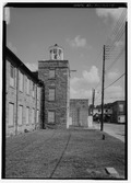
| 1 | William Aiken House and Associated Railroad Structures |
.jpg) |
(#66000698) |
Charleston 32°47′21″N 79°56′15″W / 32.789167°N 79.9375°W |
Charleston | This landmark includes the home of William Aiken, who founded the South Carolina Canal and Railroad Company. This railroad was the longest operating one in the world in 1833! |
| 2 | Atalaya and Brookgreen Gardens |
 |
(#84002045) |
Murrells Inlet 33°30′50″N 79°05′07″W / 33.513889°N 79.085278°W |
Georgetown | This landmark combines Atalaya and parts of Brookgreen Gardens. It's connected to the famous artist Anna Hyatt Huntington. |
| 3 | Beaufort Historic District |
 |
(#69000159) |
Beaufort 32°26′08″N 80°40′04″W / 32.435556°N 80.667778°W |
Beaufort | A historic area in Beaufort with many old and important buildings. |
| 4 | Bethesda Presbyterian Church |
.jpg) |
(#85003258) |
Camden 34°14′48″N 80°36′19″W / 34.246589°N 80.605213°W |
Kershaw | This church was designed by the famous architect Robert Mills. |
| 5 | William Blacklock House |
.jpg) |
(#73001681) |
Charleston 32°46′59″N 79°56′22″W / 32.782927°N 79.939353°W |
Charleston | An Adamesque style house, possibly designed by Gabriel Manigault. |
| 6 | Borough House |
.jpg) |
(#72001224) |
Stateburg 33°57′14″N 80°32′16″W / 33.953889°N 80.537778°W |
Sumter | This site has the oldest and largest collection of 'pise de terre' (which means rammed earth) buildings in the United States. |
| 7 | Miles Brewton House |
 |
(#66000699) |
Charleston 32°46′20″N 79°55′56″W / 32.772131°N 79.932201°W |
Charleston | A great example of a "double house" in Charleston, meaning it has four main rooms on each floor. |
| 8 | Robert Brewton House |
 |
(#66000700) |
Charleston 32°46′28″N 79°55′45″W / 32.774388°N 79.929041°W |
Charleston | This is Charleston's oldest known "single" house. It's one room wide, with the narrow side facing the street. |
| 9 | Brick House Ruins |
.jpg) |
(#70000580) |
Edisto Island 32°35′59″N 80°19′32″W / 32.599774°N 80.325420°W |
Charleston | These are the ruins of a plantation house that burned down in 1929. |
| 10 | Burt-Stark Mansion |
.jpg) |
(#70000559) |
Abbeville 34°10′49″N 82°22′55″W / 34.180317°N 82.382023°W |
Abbeville | This is the place where the American Civil War officially ended. |
| 11 | Camden Battlefield |
.jpg) |
(#66000707) |
Camden 34°20′47″N 80°36′27″W / 34.346389°N 80.6075°W |
Kershaw | This field was the site of the Battle of Camden in 1780, a big British victory during the Revolutionary War. |
| 12 | Chapelle Administration Building |
.jpg) |
(#76001710) |
Columbia 34°00′37″N 81°01′15″W / 34.010263°N 81.020966°W |
Richland | This building at Allen University was designed by John A. Lankford, who was known as the "dean of black architecture." |
| 13 | Charlesfort-Santa Elena Site |
.jpg) |
(#74001822) |
Parris Island 32°18′23″N 80°40′32″W / 32.306389°N 80.675556°W |
Beaufort | This archaeological site holds the remains of a French fort built in 1562 and Spanish forts from 1566. |
| 14 | Charleston Historic District |
.jpg) |
(#78002497) |
Charleston 32°47′08″N 79°56′13″W / 32.785556°N 79.936944°W |
Charleston | A large historic area in Charleston with many important buildings. |
| 15 | Church of the Holy Cross |
 |
(#73001732) |
Stateburg 33°57′39″N 80°31′55″W / 33.960744°N 80.531944°W |
Sumter | This Gothic Revival church was built in 1852 using rammed earth. It's right across from Borough House. |
| 16 | USS Clamagore |
 |
(#89001229) |
Mount Pleasant 32°47′16″N 79°54′28″W / 32.787883°N 79.907744°W |
Charleston | This submarine was being trained when World War II ended. |
| 17 | Coker Experimental Farms |
.jpg) |
(#66000706) |
Hartsville 34°21′47″N 80°03′35″W / 34.363056°N 80.059722°W |
Darlington | This is where important experiments happened that helped improve crops. These experiments greatly changed farming in the South. |
| 18 | College of Charleston |
 |
(#71000748) |
Charleston 32°47′03″N 79°56′17″W / 32.784167°N 79.938056°W |
Charleston | The historic center of this college campus is very beautiful. Buildings like Randolph Hall were designed by famous architects. |
| 19 | Drayton Hall |
 |
(#66000701) |
Charleston 32°52′15″N 80°04′35″W / 32.8709°N 80.0763°W |
Charleston | A plantation house built in 1742 in the Palladian style. |
| 20 | Exchange and Provost |
 |
(#69000160) |
Charleston 32°46′37″N 79°55′37″W / 32.776842°N 79.927009°W |
Charleston | This building has been many things: a customhouse, a market, a military prison, a post office, and even where the State Legislature met in 1790. |
| 21 | Farmers' and Exchange Bank |
.jpg) |
(#73001685) |
Charleston 32°46′39″N 79°55′37″W / 32.777435°N 79.926964°W |
Charleston | A very unique bank building built in 1854, designed in a Moorish style. |
| 22 | Fig Island |
(#70000585) |
Charleston 32°34′13″N 80°12′55″W / 32.5703°N 80.2153°W |
Charleston | This archaeological site is one of the most complex shell-ring sites in the United States. | |
| 23 | Fireproof Building |
 |
(#69000161) |
Charleston 32°46′37″N 79°55′52″W / 32.776923°N 79.931052°W |
Charleston | Designed by Robert Mills, this building was meant to be the most fireproof in America. Today, it houses the South Carolina Historical Society. |
| 24 | First Baptist Church |
 |
(#71000800) |
Columbia 34°00′21″N 81°02′00″W / 34.005864°N 81.033450°W |
Richland | This is where the American Civil War began, when South Carolina decided to leave the Union. |
| 25 | Fort Hill (John C. Calhoun House) |
 |
(#66000708) |
Clemson 34°40′34″N 82°50′21″W / 34.675976°N 82.839208°W |
Pickens | This was the home of John C. Calhoun, an important political leader. It's now part of the Clemson University campus. |
| 26 | William Gibbes House |
 |
(#70000575) |
Charleston 32°46′15″N 79°56′04″W / 32.770701°N 79.934493°W |
Charleston | An Adamesque style home with a beautiful ballroom, fancy ironwork, and marble steps. |
| 27 | Graniteville Historic District |
 |
(#78002491) |
Graniteville 33°34′01″N 81°48′30″W / 33.566893°N 81.808377°W |
Aiken | This is a textile mill town with a Gothic revival church and unique homes. |
| 28 | Hampton Plantation |
 |
(#70000582) |
McClellanville 33°11′54″N 79°26′16″W / 33.198333°N 79.437778°W |
Charleston | This is a great example of a large, two-and-a-half story Georgian plantation house in South Carolina. |
| 29 | Dubose Heyward House |
.jpg) |
(#71000749) |
Charleston 32°46′29″N 79°55′45″W / 32.774663°N 79.929029°W |
Charleston | This was the home of Dubose Heyward, who wrote the famous novel Porgy. |
| 30 | Heyward-Washington House |
 |
(#70000576) |
Charleston 32°46′31″N 79°55′45″W / 32.775337°N 79.929125°W |
Charleston | George Washington stayed in this house when he visited Charleston in 1792. |
| 31 | Hibernian Hall |
 |
(#73001686) |
Charleston 32°46′39″N 79°55′52″W / 32.777469°N 79.931148°W |
Charleston | A historic hall in Charleston. |
| 32 | Hopsewee |
.jpg) |
(#71000782) |
Georgetown 33°12′38″N 79°23′05″W / 33.210556°N 79.384722°W |
Georgetown | This plantation mansion was built in 1749. It's the birthplace of Thomas Lynch Jr., who signed the Declaration of Independence. |
| 33 | Huguenot Church |
 |
(#73001687) |
Charleston 32°46′41″N 79°55′46″W / 32.778090°N 79.929312°W |
Charleston | A Gothic Revival church built in 1844, designed by architect E. B. White. |
| 34 | Kahal Kadosh Beth Elohim |
 |
(#78002499) |
Charleston 32°46′55″N 79°55′59″W / 32.781979°N 79.932948°W |
Charleston | This Greek Revival building from 1840 is the second oldest synagogue in the United States that has been used continuously. |
| 35 | USS Laffey |
 |
(#83002189) |
Mount Pleasant 32°47′16″N 79°54′28″W / 32.787883°N 79.907744°W |
Charleston | A famous destroyer ship. |
| 36 | Lancaster County Courthouse |
,_Lancaster,_South_Carolina.jpg) |
(#71000788) |
Lancaster 34°43′17″N 80°46′17″W / 34.721264°N 80.771369°W |
Lancaster | This courthouse has been used since 1828. It was designed by Robert Mills. |
| 37 | Lancaster County Jail |
_Jail.jpg) |
(#71000789) |
Lancaster 34°43′06″N 80°46′17″W / 34.718335°N 80.771270°W |
Lancaster | This old jail building was built in 1823. It's a great example of Robert Mills's innovative jail designs. |
| 38 | Joseph Manigault House |
 |
(#73001688) |
Charleston 32°47′19″N 79°56′08″W / 32.788703°N 79.935558°W |
Charleston | This home was designed by Gabriel Manigault for his brother. |
| 39 | Market Hall and Sheds |
 |
(#73001689) |
Charleston 32°46′51″N 79°55′53″W / 32.780720°N 79.931515°W |
Charleston | A Greek Revival meat market with sheds where vegetables and fish were sold. |
| 40 | Marshlands |
 |
(#73001674) |
Beaufort 32°26′01″N 80°39′57″W / 32.433520°N 80.665831°W |
Beaufort | This was the home of Dr. James Robert Verdier, who found a way to treat yellow fever. |
| 41 | Middleburg Plantation |
.jpg) |
(#70000568) |
Huger 33°04′52″N 79°50′35″W / 33.081111°N 79.843056°W |
Berkeley | One of the earliest frame plantation houses in South Carolina. |
| 42 | Middleton Place |
 |
(#71000770) |
Summerville 32°53′59″N 80°08′12″W / 32.899722°N 80.136667°W |
Dorchester | A beautiful plantation mansion with amazing gardens along the Ashley River. |
| 43 | Millford Plantation |
 |
(#71000808) |
Pinewood 33°44′54″N 80°32′15″W / 33.7484°N 80.53745°W |
Sumter | A huge, two-story Greek Revival mansion built in 1839. It was carefully restored in the 1990s. |
| 44 | Mills Building, South Carolina State Hospital |
 |
(#70000890) |
Columbia 34°00′55″N 81°02′03″W / 34.015160°N 81.034151°W |
Richland | Designed by Robert Mills, this building was used from 1827 to 1937. It's one of the first mental hospitals built with public money. |
| 45 | Clark Mills Studio |
.jpg) |
(#66000703) |
Charleston 32°46′36″N 79°55′46″W / 32.776597°N 79.929503°W |
Charleston | This was the studio of Clark Mills, a sculptor who taught himself art. |
| 46 | Robert Mills House |
 |
(#70000595) |
Columbia 34°00′34″N 81°01′45″W / 34.009444°N 81.029167°W |
Richland | This home was designed by the famous architect Robert Mills. |
| 47 | Mulberry Plantation |
.jpg) |
(#66000697) |
Moncks Corner 33°08′31″N 80°01′04″W / 33.141944°N 80.017778°W |
Berkeley | Built in 1714 for a Royal governor, this is one of the earliest plantation homes in the United States. |
| 48 | Mulberry Plantation (James and Mary Boykin Chesnut House) |
.jpg) |
(#80003673) |
Camden 34°12′24″N 80°35′31″W / 34.206528°N 80.591944°W |
Kershaw | This was the home of Mary Boykin Chesnut. Her diary about Southern society during the Civil War is considered very important. |
| 49 | Ninety-Six and Star Fort |
 |
(#69000169) |
Ninety Six 34°08′49″N 82°01′28″W / 34.146944°N 82.024444°W |
Greenwood | A historic site that played a role in the Revolutionary War. |
| 50 | Old Marine Hospital |
.jpg) |
(#73001690) |
Charleston 32°46′39″N 79°56′15″W / 32.777621°N 79.937483°W |
Charleston | This Gothic Revival building was designed by Robert Mills and built in 1833 to help sick sailors. |
| 51 | Parish House of the Circular Congregational Church |
.jpg) |
(#73001683) |
Charleston 32°46′45″N 79°55′53″W / 32.779032°N 79.931308°W |
Charleston | This parish house was designed by Robert Mills. |
| 52 | Penn School Historic District |
 |
(#74001824) |
Frogmore 32°23′18″N 80°34′31″W / 32.3883°N 80.5753°W |
Beaufort | This school was for freed slaves, known as Gullahs, on St. Helena Island during the Civil War. |
| 53 | Pompion Hill Chapel |
.jpg) |
(#70000567) |
Huger 33°05′12″N 79°50′12″W / 33.086667°N 79.836667°W |
Berkeley | An Episcopal chapel built in 1763 that remains unchanged. |
| 54 | Powder Magazine |
 |
(#72001200) |
Charleston 32°46′47″N 79°55′47″W / 32.779656°N 79.929791°W |
Charleston | This is the oldest public building in Charleston. |
| 55 | Joseph H. Rainey House |
 |
(#84003877) |
Georgetown 33°22′07″N 79°17′02″W / 33.368607°N 79.283817°W |
Georgetown | This was the home of Joseph H. Rainey, the first black U.S. Congressman, who was formerly enslaved. |
| 56 | Robert Barnwell Rhett House |
 |
(#73001691) |
Charleston 32°47′11″N 79°56′33″W / 32.786250°N 79.942502°W |
Charleston | The home of Robert Barnwell Rhett, a politician who strongly supported states leaving the Union before the Civil War. |
| 57 | Robert William Roper House |
.jpg) |
(#73001692) |
Charleston 32°46′14″N 79°55′42″W / 32.770529°N 79.928419°W |
Charleston | A historic house in Charleston. |
| 58 | Nathaniel Russell House |
.JPG) |
(#71000750) |
Charleston 32°46′27″N 79°55′51″W / 32.774177°N 79.930737°W |
Charleston | An Adamesque style house finished in 1808. |
| 59 | Edward Rutledge House |
.jpg) |
(#71000751) |
Charleston 32°46′34″N 79°56′01″W / 32.776202°N 79.933560°W |
Charleston | This was the home of Edward Rutledge, who signed the Declaration of Independence and was a governor of South Carolina. |
| 60 | John Rutledge House |
 |
(#71000752) |
Charleston 32°46′34″N 79°56′01″W / 32.776231°N 79.933563°W |
Charleston | The home of Governor John Rutledge, who signed the U.S. Constitution. |
| 61 | St. James Church, Goose Creek |
.jpg) |
(#70000566) |
Goose Creek 32°58′25″N 80°01′47″W / 32.973616°N 80.029594°W |
Berkeley | An Episcopal chapel. |
| 62 | St. James Church, Santee |
.jpg) |
(#70000581) |
Georgetown 33°10′13″N 79°27′56″W / 33.170166°N 79.46569°W |
Charleston | A historic church. |
| 63 | Saint Michael's Episcopal Church |
.jpg) |
(#66000704) |
Charleston 32°46′33″N 79°55′51″W / 32.775963°N 79.930931°W |
Charleston | Built in the 1750s, this is Charleston's oldest church building. |
| 64 | St. Philip's Episcopal Church |
.jpg) |
(#73001695) |
Charleston 32°46′44″N 79°55′46″W / 32.778874°N 79.929469°W |
Charleston | This church has a steeple designed by E. B. White. |
| 65 | St. Stephen's Episcopal Church |
.jpg) |
(#70000570) |
St. Stephen 33°24′19″N 79°55′00″W / 33.4054°N 79.9166°W |
Berkeley | A small Georgian brick country church with a high roof. |
| 66 | Simmons-Edwards House |
.jpg) |
(#71000753) |
Charleston 32°46′22″N 79°56′02″W / 32.7729°N 79.93397°W |
Charleston | Locals call this the "Pineapple Gate House" because of the pineapple shapes on its large brick gates. |
| 67 | Robert Smalls House |
.jpg) |
(#74001823) |
Beaufort 32°26′07″N 80°40′05″W / 32.435156°N 80.668186°W |
Beaufort | This was the home of U.S. congressman Robert Smalls. He was formerly enslaved and became famous for taking a Confederate ship to Union lines during the Civil War. |
| 68 | Snee Farm |
 |
(#73001702) |
Mount Pleasant 32°50′46″N 79°49′29″W / 32.846111°N 79.824722°W |
Charleston | The home of early South Carolina Governor Charles Pinckney. |
| 69 | Snow's Island |
(#73001708) |
Across the Peedee River from Dunham Bluff, near Johnsonville 33°50′13″N 79°20′28″W / 33.8369°N 79.3411°W |
Florence | This island was a hiding place for the "Swamp Fox," Francis Marion, during the Revolutionary War. | |
| 70 | South Carolina State House |
 |
(#70000598) |
Columbia 34°00′02″N 81°01′59″W / 34.000433°N 81.033147°W |
Richland | This Greek Revival capitol building was finished in 1907. It had big updates in 1959 and 1998. |
| 71 | Stono River Slave Rebellion Site |
 |
(#74001840) |
Rantowles 32°47′08″N 80°08′44″W / 32.785501°N 80.145560°W |
Charleston | This is where one of the earliest slave revolts in the United States began. |
| 72 | Colonel John Stuart House |
 |
(#70000578) |
Charleston 32°46′28″N 79°56′02″W / 32.774370°N 79.933807°W |
Charleston | The home of Colonel John Stuart. |
| 73 | Unitarian Church |
.jpg) |
(#73001696) |
Charleston 32°46′41″N 79°56′04″W / 32.778149°N 79.934554°W |
Charleston | This church was built in 1772 and later updated in a Gothic style between 1852 and 1854. |
| 74 | Denmark Vesey House |
 |
(#76001698) |
Charleston 32°46′56″N 79°56′28″W / 32.782209°N 79.941180°W |
Charleston | This is believed to be the home of Denmark Vesey, who was accused of planning a slave rebellion in 1822. |
| 75 | Woodlands |
.jpg) |
(#71000742) |
Bamberg 33°17′27″N 80°55′53″W / 33.29085°N 80.931271°W |
Bamberg | This was the main home of author William Gilmore Simms. His main house burned down in 1865, but the remaining parts are still an important literary landmark. |
| 76 | USS Yorktown |
 |
(#82001519) |
Mount Pleasant 32°47′20″N 79°54′31″W / 32.788792°N 79.908588°W |
Charleston | A famous aircraft carrier from World War II. |
Other Important National Park Sites
Besides the National Historic Landmarks, there are other special historic places in South Carolina that are part of the National Park System. These sites are already highly protected. Two of them, Charles Pinckney National Historic Site (also called Snee Farm) and Ninety Six National Historic Site, are also listed as NHLs above. Here are three more:
| Landmark Name | Image | Date Established | Location | County | Description | |
|---|---|---|---|---|---|---|
| 1 | Cowpens National Battlefield |  |
March 4, 1929 | Gaffney | Cherokee | This is where the Battle of Cowpens happened in 1781, a key battle in the Revolutionary War. |
| 2 | Fort Sumter National Monument | April 28, 1948 | Charleston | Charleston | The first shots of the American Civil War were fired here on January 9, 1861. The Battle of Fort Sumter followed soon after. | |
| 3 | Kings Mountain National Military Park | March 3, 1931 | Blacksburg | Cherokee | The site of the Battle of Kings Mountain on October 7, 1780, another important Revolutionary War battle. |
Former National Historic Landmarks
Sometimes, a place might lose its National Historic Landmark status. This can happen if it's moved or if it's destroyed. For example, the nuclear-powered ship NS Savannah was moved to Virginia. Also, Piedmont Number One, an old textile mill, sadly burned down in 1983.
| Landmark Name | Image | Date Designated | Date Moved or Removed |
Location | County | Description | |
|---|---|---|---|---|---|---|---|
| 1 | NS Savannah |  |
July 17, 1991 | 1994 | Patriot's Point, Charleston | Charleston | This was a nuclear-powered cargo and passenger ship. It was at Patriot's Point from 1982 to 1994, then moved to Baltimore, Maryland, and later to Virginia. |
| 2 | Piedmont Number One | .jpg) |
June 2, 1978 | March 5, 1986 | Piedmont | Greenville | This historic textile mill burned down in 1983. Its National Historic Landmark status was removed in 1986. |
See also
