
National Register of Historic Places listings in Breckinridge County, Kentucky facts for kids

Have you ever wondered about old buildings or special places that tell a story about the past? In Breckinridge County, Kentucky, there are several important spots that are officially recognized for their history! These places are listed on the National Register of Historic Places. It's like a special list kept by the United States government to protect and celebrate places that are important to American history, architecture, archaeology, engineering, or culture.
When a place is added to this list, it means it's considered valuable and worth preserving for future generations. It helps people learn about what life was like long ago and understand how communities grew. In Breckinridge County, there are 11 different places and areas that have earned a spot on this special list. They include old homes, entire historic neighborhoods, and even ancient sites where people lived thousands of years ago!
Historic Places in Breckinridge County
These are some of the fascinating places in Breckinridge County that are listed on the National Register of Historic Places. Each one has a unique story to tell about the area's past.
Historic Districts
Historic districts are areas that include several buildings or structures that are important together. They often show how a town or neighborhood looked and functioned a long time ago.
Cloverport Historic District
The Cloverport Historic District is located in the town of Cloverport. It includes many buildings that show the history and architecture of the town. This district was added to the National Register on June 21, 1983. It's a great place to see what a historic Kentucky town looks like.
Falls of Rough Historic District
The Falls of Rough Historic District is found in Falls of Rough. This area is special because it shows how communities developed around natural features like rivers. It was recognized on January 31, 1978.
Irvington Historic District
In Irvington, the Irvington Historic District includes a section of the town with important historical buildings. It was added to the list on June 29, 1998, helping to preserve the town's unique character.
Historic Homes and Buildings
Many individual homes and buildings are also recognized for their historical importance, often because of their age, unique design, or connection to famous people.
Fisher Homestead
The Fisher Homestead is an old farm home located near Cloverport. It was listed on the National Register on June 21, 1983. Homesteads like this give us a glimpse into how families lived and worked in the past.
Joseph Holt House and Chapel
The Joseph Holt House and Chapel is southwest of Addison. This historic property belonged to Joseph Holt, a very important person in American history. He served as a judge and even as a cabinet member for President Abraham Lincoln. The house and chapel were added to the list on July 12, 1976.
Oglesby-Conrad House
Another historic home near Cloverport is the Oglesby-Conrad House. It was recognized on June 21, 1983. This house is a good example of the architecture from its time period.
Skillman House
The Skillman House, also in Cloverport, is another important historic residence. It was listed on the National Register on June 21, 1983.
Ancient Sites and Petroglyphs
Some of the most fascinating listings are archaeological sites and petroglyphs, which are ancient rock carvings. These places help us understand the very first people who lived in Kentucky.
Holt Bottoms Archeological District
The Holt Bottoms Archeological District near Holt is a very important archaeological site. Because these sites are so delicate and important for research, their exact locations are often kept secret to protect them. This district was added to the National Register on November 16, 1978.
Mattingly Petroglyphs
The Mattingly Petroglyphs are ancient rock carvings found near Mattingly. Petroglyphs are like drawings or symbols carved into rock by early inhabitants, giving us clues about their lives and beliefs. These were listed on September 8, 1989.
North Fork Rough River Petroglyph
Another important rock carving site is the North Fork Rough River Petroglyph (15BC130), located near Roff. Like other archaeological sites, its exact location is restricted to protect it. It was added to the National Register on September 8, 1989.
Tar Springs Petroglyphs
The Tar Springs Petroglyphs (15BC129), found near Cloverport, are also ancient rock carvings. These sites are like open-air museums, showing us art and messages from people who lived thousands of years ago. They were listed on September 8, 1989.
Images for kids
-
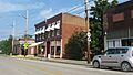
A building in the Cloverport Historic District.
-
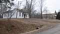
A view of the Falls of Rough area.
-
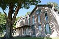
The historic Joseph Holt House.
-
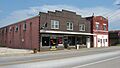
A street view in the Irvington Historic District.


