
National Register of Historic Places listings in Butler County, Kentucky facts for kids

Welcome to Butler County, Kentucky! This page is all about the amazing and important places here that are listed on the National Register of Historic Places. Think of this register as a special list of buildings, sites, and objects that are super important to America's history. By putting them on this list, we help protect them for future generations.
In Butler County, there are 16 different places on this list. Six of these are part of a much bigger historic area that spreads across several counties. One place used to be on the list but was later removed. Let's explore some of these cool historic spots!
What is the National Register of Historic Places?
The National Register of Historic Places (NRHP) is the official list of places in the United States that are worth saving. These places could be buildings, structures, objects, sites, or even entire historic districts. They are important because they tell us stories about the past. They might show us how people lived, worked, or what events happened there.
When a place is added to the NRHP, it gets special recognition. This helps people understand why it's important and encourages them to protect it. It also means that certain rules apply to make sure these historic treasures are not damaged or destroyed.
Discovering Butler County's Historic Sites
Butler County is home to many fascinating places that have earned a spot on the National Register. These sites offer a peek into different times in history, from ancient Native American settlements to buildings from more recent centuries. Let's take a closer look at some of them.
Ancient Sites and Shell Mounds
Many of Butler County's oldest historic sites are connected to the Green River. Long ago, Native American communities lived along this river. They left behind clues about their lives, often in the form of "shell mounds." These mounds are like ancient trash heaps, made up of shells from mussels and other foods they ate. They also contain tools, pottery, and other artifacts. These sites help archaeologists learn about early human history.
- Annis Mound and Village Site is located on the western bank of the Green River, near Logansport. It's a significant spot where ancient people lived.
- Carlston Annis Shell Mound is another important shell mound found on the eastern side of the Green River. It's part of a larger area called the Green River Shell Middens Archeological District.
- DeWeese Shell Mound is also on the eastern bank of the Green River. This site, like Carlston Annis, is part of the Green River Shell Middens Archeological District.
- Rayburn Johnson Shell Mound is another shell mound found on the eastern bank of the Green River. It's also part of the important Green River Shell Middens Archeological District.
- Read Shell Mound is located on the northern side of the Green River, west of Morgantown. This site also belongs to the Green River Shell Middens Archeological District.
- Russell Shell Mound is on the eastern bank of the Green River near Logansport. It is another part of the Green River Shell Middens Archeological District.
- Woodbury Shell Midden is found on the left bank of the Green River, right above Woodbury. This site is also part of the Green River Shell Middens Archeological District.
Mysterious Rock Carvings (Petroglyphs)
Some of Butler County's historic sites feature ancient rock carvings, known as petroglyphs. These carvings were made by early people and can show animals, symbols, or other designs. They are like ancient art or messages left on stone.
- Baby Track Rock Petroglyphs are located near Morgantown. The exact address is kept secret to protect these fragile carvings.
- Reedyville Petroglyphs are found near the Green River in Reedyville.
- Turkey Rock Petroglyphs are another set of rock carvings near Morgantown. Like the Baby Track Rock Petroglyphs, their location is restricted for protection.
Historic Buildings and Farms
Butler County also has several historic buildings and farms that tell us about life in the 19th and 20th centuries.
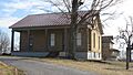
- John Carson House is a historic home located at 205 South Main Street in Morgantown. It was listed in 1991.
- Carson-Annis Ferry Farm is a historic farm at 1086 Annis Ferry Road near Morgantown. It was first listed in 1998 and later had its boundaries expanded in 2007.
- Finney Hotel is an old hotel located at the junction of Kentucky Route 403 and Hime Street in Woodbury. It was listed in 1995.
- Ice House on Little Muddy Creek is a unique historic structure found on U.S. Route 231 near Morgantown. It was listed in 1987.
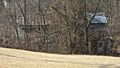
- U.S. Army Corps of Engineers Superintendent's House and Workmen's Office are historic buildings located in Woodbury Park. These buildings were important for managing the river navigation system. They were listed in 1980.
Monuments and Memorials
Monuments often mark important events or honor people from the past.
- Confederate-Union Veterans' Monument in Morgantown is a special monument that honors soldiers from both sides of the American Civil War. It is located one block north of the junction of U.S. Route 231 and Kentucky Route 403 in Morgantown. It was listed in 1997.
Former Listing
Sometimes, a place that was once on the National Register of Historic Places might be removed. This can happen if the building is destroyed, or if it changes so much that it no longer has its historic importance.
- Butler County Jail was located at South Warren and East Logan Streets in Morgantown. It was listed in 1984 but was removed from the list in 1990.
Images for kids
-
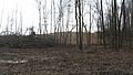
The Annis Village Site, an important archaeological area.
-
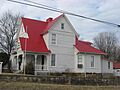
The historic John Carson House in Morgantown.
-
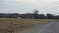
The Carson-Annis Ferry Farm.
-
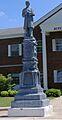
The Confederate-Union Veterans' Monument in Morgantown.
-
The Finney Hotel in Woodbury.
-
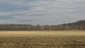
The site of the Rayburn Johnson Shell Mound.
-
Historic buildings at Woodbury Lock 4.
-
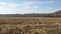
The Woodbury Shell Midden site.


