
National Register of Historic Places listings in Clark County, Kentucky facts for kids

Welcome to Clark County, Kentucky! This page is all about special places in our county that are listed on the National Register of Historic Places. Think of it like a Hall of Fame for buildings, areas, and sites that are important to history. These places are protected because they tell us stories about the past.
There are 68 amazing properties and historic areas in Clark County that have been added to this important list. They include old homes, churches, schools, and even entire neighborhoods! Let's explore some of these cool historic spots.
Historic Buildings and Homes
Many of the places on the National Register are old buildings and houses. They show us how people lived, worked, and built things long ago.
Important Houses
Clark County has many historic homes, each with its own story.
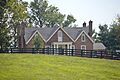
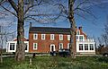
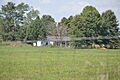
Boot Hill Farm

Boot Hill Farm is a historic farm located near Athens. It was added to the list in 1985. Farms like this one are important because they show us how agriculture shaped our county.
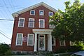
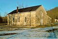
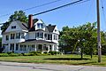
Capt. Robert V. Bush House
The Capt. Robert V. Bush House is a historic home in Becknerville. It was recognized in 1979. This house helps us remember the people who lived here many years ago.
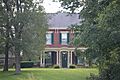
W. Bush-Dykes House

The W. Bush-Dykes House, located near Forest Grove, is another historic home listed in 1979. It includes the main house and other old buildings, giving us a peek into past farm life.
Tarleton Chiles House

The Tarleton Chiles House, also in Becknerville, was added to the list in 1979. Even if only the site remains, it marks a place of historical importance.
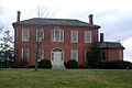
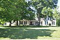
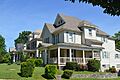
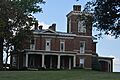
Governor Clark House

The Governor James A. Clark Mansion in Winchester was listed in 1974. This grand house was once home to Governor James A. Clark, an important figure in Kentucky's history.
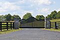
William Clinkenbeard House

The William Clinkenbeard House, found on Old Paris Pike near Winchester, became historic in 1980. Its gate gives us a glimpse of its old-world charm.
Colby Tavern

Colby Tavern, located at the junction of Colby and Becknerville Roads, was listed in 1979. Taverns were like hotels and restaurants in the past, important stops for travelers.
Gen. Thomas Hart House

The Gen. Thomas Hart House on Ecton Road near Winchester was added in 1979. General Thomas Hart was a notable person in the early history of the area.
William Hickman House

The William Hickman House, located on West Hickman Street in Winchester, was listed in 1982. This house is a great example of older architecture in the city.
Hodgkins House

The Hodgkins House, on Old Boonesborough Road near Winchester, was recognized in 1979. It's another example of the many historic homes in the area.
Hood-Tucker House

The Hood-Tucker House on French Avenue in Winchester was added to the list in 2007. It's a more recent addition, showing that history is always being discovered.
Maj. John Martin House

The Maj. John Martin House, on Basin Springs Road near Pine Grove, was listed in 1982. This house tells us about the people who settled and built up the region.
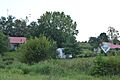
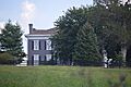
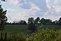
Owen-Gay Farm

The Owen-Gay Farm, located at the Bourbon County line, was listed in 1997. This farm is special because it extends into another county, showing how history connects places.
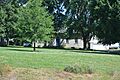
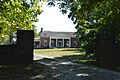
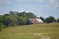
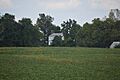
Maj. Walter Preston House

The Maj. Walter Preston House, on Basin Springs Road in Becknerville, was listed in 1979. The image shows a barn from the farm, reminding us of the agricultural past.
W. Pruett House

The W. Pruett House on Ecton Road near Winchester was added in 1980. It's another example of a well-preserved historic home.
J. Quisenberry House

The J. Quisenberry House, on Quisenberry Road near Forest Grove, was listed in 1979. This house is part of the rich history of homes in Clark County.
Springhill

Springhill, located north of Winchester on Colby Road, was added in 1978. It's a beautiful historic property that has stood for many years.
Stanley F. Tebbs House

The Stanley F. Tebbs House, on Todd's Road near Pine Grove, was listed in 1979. This house is a great example of the architecture from its time.
Van Meter Distillery

The Van Meter Distillery on Van Meter Road in Winchester was listed in 1979. Distilleries were important businesses in Kentucky's history.
Vinewood

Vinewood, northeast of Winchester on US Route 60, was added in 1977. This property is a significant part of the county's heritage.
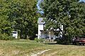
Wade Farmstead

The Wade Farmstead on Donaldson Road in Winchester was listed in 1979. This farmhouse represents the long history of farming in the area.
Woodford-Fishback-Venable Farm

The Woodford-Fishback-Venable Farm on Combs Ferry Road in Winchester was added in 2008. This farm shows how important agriculture has been to Clark County.
Churches and Schools
Some historic places are community buildings like churches and schools.
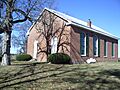
Corinth Christian Methodist Episcopal Church
.jpg)
The Corinth Christian Methodist Episcopal Church on L E Junction Road in Winchester was listed in 2007. Churches often serve as important centers for communities for many years.
Goshen Primitive Baptist Church

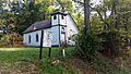
The Goshen Primitive Baptist Church on Goshen Road in Winchester was added in 1979. This church is a historic landmark for its religious and community importance.
Old Providence Church

Old Providence Church, southwest of Winchester, was listed in 1976. This old church has seen many years of history unfold.
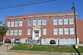
Oliver School

Oliver School on Oliver Street in Winchester was added in 2004. Old schools like this one remind us of how education has changed over time.
Victory Heights Elementary School

Victory Heights Elementary School on Maryland Avenue in Winchester was listed in 2004. It's another example of a school building that holds historical value.
Other Notable Buildings
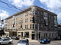
Brown-Proctoria Hotel

The Brown-Proctoria Hotel, located at Main Street and Lexington Avenue in Winchester, was listed in 1977. This old hotel was once a busy place for travelers and visitors.
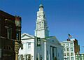
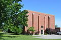
Clark County Court House

The Clark County Court House on Main Street in Winchester was added in 1974. This building is important because it's where many local government decisions have been made for decades.
Historic Districts and Areas
Sometimes, it's not just one building that's historic, but a whole area! These are called "historic districts."
Boone Creek Rural Historic District
The Boone Creek Rural Historic District is a large area that extends into Fayette County. It was listed in 1994. These rural districts protect the historic landscape and farms.
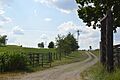
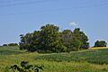
Middle Reaches of Boone Creek Rural Historic District
Another part of the Boone Creek area, this district was listed in 1996. It helps preserve the historic feel of the countryside.
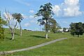
Upper Reaches of Boone Creek Rural Historic District
The Upper Reaches of Boone Creek Rural Historic District was added in 2009. Together, these districts protect a large, important rural landscape.
South Park Neighborhood

The South Park Neighborhood in Winchester was listed in 2008. This district includes many historic homes and streets, showing how people lived in a neighborhood setting.
Thomson Neighborhood District

The Thomson Neighborhood District in Winchester was added in 1992. It's another area where many historic homes are preserved together.
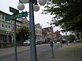
Winchester Downtown Commercial District

The Winchester Downtown Commercial District was listed in 1982. This area includes many historic shops and businesses in the heart of Winchester. It shows how the town grew and developed.
Ancient Sites
Clark County also has very old sites that tell us about people who lived here long, long ago.
Civil War Fort at Boonesboro
The Civil War Fort at Boonesboro, north of Ford, was listed in 2003. This site is important because it was used during the American Civil War.
Mound Hill Archaeological Site

The Mound Hill Archaeological Site, west of the Devil's Backbone, was added in 1978. This site contains clues about ancient cultures that lived in the area thousands of years ago.
Indian Fort Earthworks (15CK7)
The Indian Fort Earthworks are an ancient site near Goffs Corner, listed in 1985. Earthworks are structures made from earth, often built by early Native American groups.
Images for kids
-
Capt. Robert V. Bush House
-
W. Bush-Dykes House and outbuildings
-
Tarleton Chiles House site
-
Clark County Court House
-
Governor James A. Clark Mansion
-
William Clinkenbeard House gate
-
Colby Tavern
-
Corinth Christian Methodist Episcopal Church
-
Goshen Primitive Baptist Church
-
Gen. Thomas Hart House
-
William Hickman House
-
Hodgkins House
-
Hood-Tucker House
-

Maj. John Martin House
-
Mound Hill Archeological Site
-
Oliver School
-
Owen-Gay Farmhouse
-
Barn at Maj. Walter Preston House
-
Old Providence Church
-
W. Pruett House
-
J. Quisenberry House
-
French Avenue in South Park Neighborhood
-
Springhill
-
Stanley F. Tebbs House
-
Maple and Belmont in Thomson Neighborhood District
-
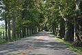
Kentucky Route 1927 near Pine Grove, in the Upper Reaches of Boone Creek Rural Historic District
-
Van Meter Distillery driveway
-
Victory Heights Elementary School
-
Vinewood
-
Wade Farmhouse
-
Downtown Winchester
-
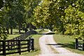
Woodford-Fishback-Venable Farm driveway and barns
-
Boot Hill Farm
-
Brown-Proctoria Hotel


