
National Register of Historic Places listings in Warren County, Kentucky facts for kids

Welcome to a list of awesome historic places in Warren County, Kentucky! These special spots are all listed on the National Register of Historic Places. This means they are important buildings, areas, or sites that tell us about the past of Kentucky and the United States.
You can see where some of these places are on a map if their exact location details are shared. There are 102 amazing places in Warren County that have made it onto this important list!
Cool Historic Places to Explore
Here are some of the interesting places in Warren County that are listed on the National Register of Historic Places. Each one has a story to tell!
Historic Homes and Buildings
Many old houses and buildings in Warren County are on the list because of their unique history or architecture.
Adams-Kentucky District
This area in Bowling Green includes several blocks of Adams Street and Kentucky Street. It's a historic district, meaning a whole group of buildings in this area are important together.

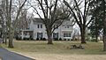
Thomas Allen House
Located in Smiths Grove, this house is a historic home that was added to the list in 1979. It's a great example of older homes in the area.

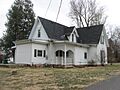
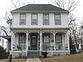
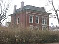
W.H. Blakeley House
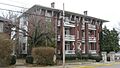
You can find this house at 1162 College Street in Bowling Green. It was recognized for its historical value in 1979.

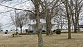
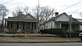
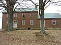
Aubrey Burnett House
This house is in Oakland on Aubrey Burnett Street. It's another example of a well-preserved historic home from 1979.

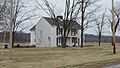
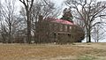
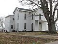
David C. Campbell House
Near Plum Springs, this house on Beech Bend Road was added to the list in 1979. It shows us what homes looked like long ago.

W.H. Everhardt House
This house at 1223 College Street in Bowling Green is a historic building from 1979.

James F. Ewing House
On Cemetery Road in Bowling Green, this house was listed in 1979. It's a significant part of the local history.

John Jackson Ford House
This historic house is located off U.S. Route 31W in Smiths Grove. It was added to the list in 1979.

William Gossom House
Found on U.S. Route 31W in Bowling Green, this house was recognized in 1979 for its historical importance.

Grider House
The Grider House at 1320 Park Street in Bowling Green is another historic home from 1979.

Tobias Grider House
Also in Bowling Green, this house at 864A Fairview Avenue was listed in 1979.

Hall House
The Hall House at 104 West Main Street in Bowling Green is a historic building from 1979.

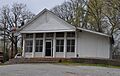
The Hardcastle Store
This old store at 7286 Cemetery Road in Bowling Green was added to the list in 2011. It gives us a peek into how people used to shop.

Hines House
The Hines House at 1103 Adams Street in Bowling Green was a historic home listed in 1979. Sadly, it burned down in 1995.

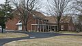
Elouise B. Houchens Center for Women
Located at 1115 Adams Street in Bowling Green, this building was listed in 1979. It's now a center for women.

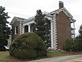
Ironwood
This historic place on Old Richardsville Road in Bowling Green was listed way back in 1973.

James Kelley House
This house on U.S. Route 68 in Bowling Green was added to the list in 1979.

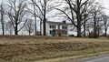
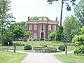
Kinlock
About 1.5 miles north of Bowling Green, Kinlock was listed in 1979. It's a beautiful old estate.

Merritt-Hardin House
This house on U.S. Route 31W in Bowling Green was listed in 1979.

Jesse Middleton House
In Oakland, on Tuckertown Road, this house was added to the list in 1979.

Milliken Building
The Milliken Building at 1039 College Street in Bowling Green was listed in 2010. It's a historic commercial building.

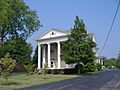
Maria Moore House
This house at 801 State Street in Bowling Green was one of the earlier listings, from 1972.

Samuel Murrell House
About 8 miles northeast of Bowling Green on U.S. Route 31W, this house was listed in 1976.

William P. Neale House
North of Woodburn, this house was added to the list in 1980.

Newton-Kemp Houses
These two houses at 804-806 Chestnut Street in Bowling Green were listed together in 1979.

Nine Hearths
Located at 1244 Park Street in Bowling Green, this unique property was listed in 1979.

Polk House
In Woodburn, on Meng Road, the Polk House was added to the list in 1979.

Rauscher House
This house at 818 Adams Street in Bowling Green was listed in 1978.

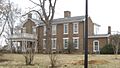
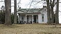
Riverview at Hobson Grove
Found in Hobson Grove Park at the end of Main Street in Bowling Green, Riverview was listed in 1972. It's a beautiful historic home.

Dr. William Robb House
On Market Street in Woodburn, this house was added to the list in 1979.

Rose-Daughtry Farmstead
This farm at 6487 Louisville Road in Bristow was listed in 2013. It's a great example of an old farm.

St. James Apartments
These apartments at 1133 Chestnut Street in Bowling Green were listed in 1984.

Edward B. Seeley House
On Beech Bend Road near Plum Springs, this house was added to the list in 1979.

Moses Shobe House
Located on U.S. Route 31W in Smiths Grove, this house was listed in 1979.

John Sloss House
On Old Springfield Road in Bowling Green, this house was added to the list in 1979.

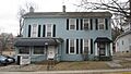
Underwood-Jones House
This house at 506 State Street in Bowling Green was listed in 1978.

Walnut Lawn
West of Bowling Green on Morgantown Road, Walnut Lawn was listed in 1983.

J.L. Wright House
On 1st Street in Smiths Grove, this house was added to the list in 1979.

Important Bridges
Bridges are also important historical structures, showing us how people traveled and built things in the past.
Barren River L & N Railroad Bridge
This railroad bridge spans the Barren River in Bowling Green. It was listed in 1980 and is a cool example of old railway engineering.

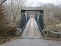
College Street Bridge
Also spanning the Barren River in Bowling Green, the College Street Bridge was listed in 1980.

Richardsville Road Bridge
This bridge also crosses the Barren River in Bowling Green and was listed in 1980.

Historic Churches
Churches often play a big role in a community's history and are important landmarks.
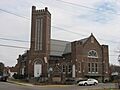
Cecelia Memorial Christian Church
Located at 716 College Street in Bowling Green, this church was listed in 1979.

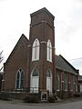
Drakes Creek Baptist Church
On Cemetery Road in Bowling Green, this church was listed in 1979. It was originally called Drakes Creek Baptist Church but was renamed Burton Memorial Baptist Church in 1911.

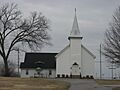
Fairview Methodist Church
This church on Kentucky Route 526 in Oakland was added to the list in 1979.

First Colored Baptist Church
Known today as State Street Baptist Church, this building at 340 State Street in Bowling Green was listed in 1979. It's an important part of the local community's history.

Mount Olivet Cumberland Presbyterian Church
This church on Kentucky Route 526 in Bowling Green was listed in 1979.

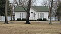
Smiths Grove Baptist Church
At Main and 5th Streets in Smiths Grove, this church was added to the list in 1979.

Smiths Grove Presbyterian Church
On College and 2nd Streets in Smiths Grove, this church was listed in 1979.

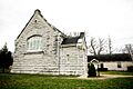
St. Joseph Roman Catholic Church
This church at 430 Church Street in Bowling Green was listed in 1975. It's a beautiful and important religious building.

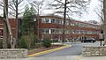
University Buildings and Sites
Western Kentucky University has several historic buildings on its campus that are recognized for their history.
Henry Hardin Cherry Hall
Known as Cherry Hall, this building on College Street at the Western Kentucky University campus in Bowling Green was listed in 1979. It's a very recognizable building on campus.

Health Buildings-Gymnasium
On Normal Drive at the Western Kentucky University campus, this building was listed in 1979.

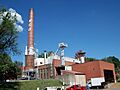
Heating Plant
The Heating Plant on Dogwood Drive at the Western Kentucky University campus was listed in 1979.

Home Economics Building
This building on State Street at the Western Kentucky University campus was listed in 1979 but was sadly destroyed in 1982.

Industrial Arts Building
On State Street at the Western Kentucky University campus, this building was listed in 1979.

Kentucky Building
Located on Russellville Road at the Western Kentucky University campus, the Kentucky Building was listed in 1979. It's home to the Kentucky Museum.

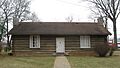
Pioneer Log Cabin
This log cabin on Kentucky Street, near University Drive, in Bowling Green was listed in 2004. It's a cool example of early pioneer homes.

President's Home
The President's Home on State Street at the Western Kentucky University campus was listed in 1979.

Perry Snell Hall
On State Street at the Western Kentucky University campus, Perry Snell Hall was listed in 1979. It was later torn down for a new building and was the last remaining building of Ogden College.

Stadium
The Stadium, including the Amphitheatre and Colonnade, on Russellville Road at the Western Kentucky University campus was listed in 1979.

Van Meter Hall
Located on 15th Street at the Western Kentucky University campus, Van Meter Hall was listed in 1979. It's a very famous building on campus.

West Hall
On Virginia Garrett Avenue at the Western Kentucky University campus, West Hall was listed in 1979.

Gordon Wilson Hall
This building on 15th Street at the Western Kentucky University campus was listed in 1979.

Other Historic Sites and Districts
Warren County also has other important historic places, like forts and commercial areas.
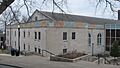
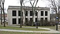
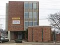
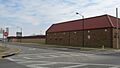
Bowling Green Organizational Maintenance Shop No. 10
This shop at 719 Old Morgantown Road in Bowling Green was listed in 2002. It's a unique example of a military maintenance facility.

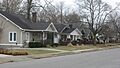
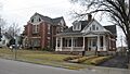
College Hill District
This historic district in Bowling Green is roughly bounded by College and Chestnut Streets, and 11th and 15th Avenues. It was listed in 1979 and expanded in 1996.

Confederate Monument of Bowling Green
This monument is in Fairview Cemetery in Bowling Green. It was listed in 1997 and is a significant historical marker.

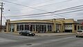
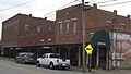
Downtown Commercial District
This busy area in Bowling Green is roughly bounded by Adams and State Streets, and 8th and 10th Avenues. It was listed in 1979 and shows what the downtown looked like long ago.

Fort C.F. Smith
Located on East Main Street in Bowling Green, this historic fort site was listed in 1984. It played a role in past conflicts.

Fort Lytle
This fort site is on the Western Kentucky University campus in Bowling Green. It was listed in 1984.

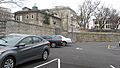
Fort Webb
On Country Club Drive in Bowling Green, Fort Webb was listed in 1984. These forts are reminders of important historical events.

Horse Shoe Camp
This camp at 8241 Louisville Road in Bowling Green was listed in 1997. It's a historic camping or gathering spot.

Lost River Archeological Cave
Also known as "Lost River Cave," this amazing underground river at 2818 Nashville Road in Bowling Green was listed in 1975. It's now a popular place for visitors!

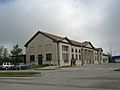
Louisville and Nashville Railroad Station
This old train station on Kentucky Street in Bowling Green was listed in 1979. It's a cool reminder of when trains were the main way to travel.

Magnolia Street Historic District
This district on Magnolia Street between Broadway and 10th Street in Bowling Green was listed in 1989. It's another area with many historic buildings.

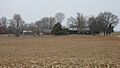
Mitchell-Estes Farmstead
This farm at 1706 Upper Smiths Grove Road in Smiths Grove was listed in 1996. Part of it even extends into Edmonson County.

Modern Automotive District
This district includes 538, 600, and 601 State Street in Bowling Green. It was listed in 2006, showing how car-related businesses became important.

Oakland-Freeport Historic District
This large district in Oakland includes many streets like Vine, Young, Lee, and Main. It was listed in 2004, preserving a whole historic part of the town.

William F. Perry Monument
This monument is also in Fairview Cemetery in Bowling Green and was listed in 1997.

Shake Rag Historic District
This district in Bowling Green is roughly bounded by the U.S. Route 31W bypass, Chestnut Street, East 5th Avenue, and College Street. It was listed in 2000 and is an important part of the city's history.

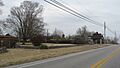
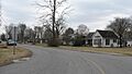
Smiths Grove Historic District
This district in Smiths Grove includes areas around 1st and Main Streets. It was listed in 1979 and expanded in 1987.

Standard Oil Company Filling Station
This old gas station at 638 College Street in Bowling Green was listed in 2010. It's a cool example of early car culture.

Upper East Main Street District
This district in Bowling Green includes East Main and Elm Streets. It was listed in 1979.

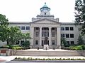
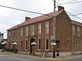
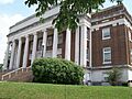
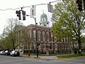
Warren County Courthouse
The courthouse at 429 East 10th Street in Bowling Green was listed in 1977. Courthouses are often central to a county's history and government.

Images for kids
-
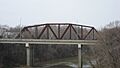
The Barren River L&N Railroad Bridge.
-

The W.H. Blakeley House.
-

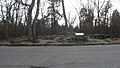
Bowling Green OMS#10.
-
The Aubrey Burnett House.
-
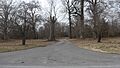
The driveway leading to the David C. Campbell House.
-

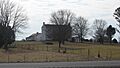
Cave Spring Farm.
-

Cecelia Memorial Presbyterian Church.
-
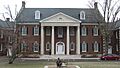
Henry Hardin Cherry Hall.
-
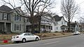
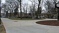
A view of the College Hill Historic District.
-
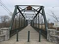
The College Street Bridge.
-
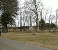
The Confederate Monument of Bowling Green.
-

The Peyton Cooke House.
-

The Curd-Moss House.
-
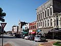
Shops along Fountain Square in Bowling Green.
-
Burton Memorial Baptist Church.
-
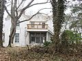
The Willis Ennis House.
-
The W.H. Everhardt House.
-
The James F. Ewing House.
-
Fairview United Methodist Church.
-
State Street Baptist Church.
-
The John Jackson Ford House.
-
Fort C.F. Smith.
-
Fort Lytle at WKU.
-
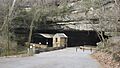
The parking area near Fort Webb.
-
The William Gossom House.
-

The Grider House.
-
The Tobias Grider House.
-

The Hall House.
-
The historic Hardcastle Store.
-
The Health Buildings-Gymnasium.
-
The Heating Plant at WKU.
-
The site where the Hines House once stood.
-
The site of the former Home Economics Building at WKU.
-
Horse Shoe Camp.
-
The Elouise B. Houchens Center for Women.
-
The Industrial Arts Building at WKU.
-
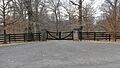
The gates at Ironwood.
-
The James Kelley House.
-
The Kentucky Building at WKU.
-

Kinlock, seen from the street.
-
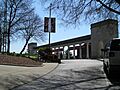
The entrance to Lost River Cave.
-
The Louisville and Nashville Railroad Station.
-
A view of the Magnolia Street Historic District.
-
The Merritt-Hardin House.
-
The Jesse Middleton House.
-
The Milliken Building.
-
The Mitchell-Estes Farmhouse.
-
A building in the Modern Automotive District.
-
The Maria Moore House.
-
Mount Olivet Cumberland Presbyterian Church.
-
The Samuel Murrell House.
-
The William P. Neale House.
-
The Newton-Kemp Houses.
-
Nine Hearths.
-
Houses on Church Street in the Oakland-Freeport Historic District.
-

The William F. Perry Monument.
-
The Pioneer Log Cabin at WKU.
-
The Polk House.
-

The President's Home at WKU.
-
The Rauscher House.
-
The Richardsville Road Bridge.
-
Riverview at Hobson Grove.
-

The Dr. William Robb House.
-
The Rose-Daughtry Farmstead.
-
The St. James Apartments.
-
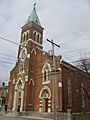
St. Joseph Roman Catholic Church.
-

A street in the St. Joseph's District.
-
The Edward B. Seeley House.
-
State Street in the Shake Rag Historic District.
-

The Moses Shobe House.
-
The John Sloss House.
-

Smiths Grove Baptist Church.
-
Main Street in downtown Smiths Grove.
-
Smiths Grove Presbyterian Church.
-
Perry Snell Hall.
-
The WKU Colonnade.
-
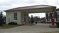
The Standard Oil Company Filling Station.
-
The Underwood-Jones House.
-
Elm and Main Streets in Bowling Green.
-
Van Meter Hall.
-

Walnut Lawn.
-
The Warren County Courthouse.
-
West Hall at WKU.
-

Gordon Wilson Hall.
-

The J.L. Wright House.


