
National Register of Historic Places listings in Barren County, Kentucky facts for kids

Have you ever wondered about the old buildings and special places in your town or county? Many of these places have amazing stories to tell! In Barren County, Kentucky, there's a special list called the National Register of Historic Places. This list helps protect and celebrate important historical spots in the United States.
It's like a hall of fame for buildings, neighborhoods, and other sites that are super important to our history. When a place is on this list, it means it's recognized for its unique past, cool architecture, or its role in big events. Barren County is home to 34 of these amazing historic places!
What is the National Register of Historic Places?
The National Register of Historic Places is the official list of the nation's historic places. It's part of a program by the U.S. government to help people understand and save important parts of our history.
When a building or area is added to this list, it doesn't mean the government owns it. It just means it's recognized as special. This recognition can help protect the place and sometimes even provide money for its upkeep. It's a way to make sure these cool places last for many more years!
Historic Places in Barren County
Barren County has many different types of places on the National Register. These include old homes, churches, banks, and even entire neighborhoods! Each one tells a piece of Barren County's story.
You can see where these places are located on a map if their exact coordinates are shared. It's like a treasure hunt for history!
Exploring Barren County's History
Here are some of the interesting places in Barren County that are on the National Register of Historic Places. Each one has a unique story and helps us learn about the past.
Belle's Tavern
Belle's Tavern is an old tavern located near Park City, Kentucky. It was added to the National Register in 1987. Imagine travelers stopping here long ago for a rest! It's a reminder of how people used to travel and where they would stay.
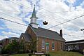
Ralph Bunche Historic District
The Ralph Bunche Historic District is a special neighborhood in Glasgow, Kentucky. It was recognized in 2004. Historic districts are areas with many buildings that together tell a story. This district is important for understanding the community's history.
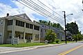
Bybee House
The Bybee House, located in Glasgow, was added to the list in 2012. Old houses like this often show us how people lived many years ago. They can have unique architectural styles that were popular in the past.
Cave City Commercial District
In Cave City, Kentucky, the Commercial District on Broadway was listed in 1983. This area was once the bustling center of trade and business. It's cool to see how the main street of a town looked and functioned in earlier times.
Confederate Monument in Glasgow
The Confederate Monument in Glasgow is a monument that was added to the National Register in 1997. Monuments like this help us remember important events and people from history, even if those times were difficult.
First National Bank (Glasgow, Kentucky)
The First National Bank building on Main Street in Glasgow became a historic site in 1983. Banks are often important buildings in a town's history, showing how the economy and community grew over time.
First Presbyterian Church (Glasgow, Kentucky)
The First Presbyterian Church, located at Washington and Broadway in Glasgow, was listed in 1983. Churches are often central to a community's social and spiritual life and can have beautiful old designs.
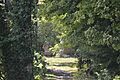
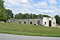
Fort Williams (Glasgow, Kentucky)
Fort Williams, located near the Glasgow Municipal Cemetery, was added to the list in 1975. This fort played a role in historical conflicts. Learning about forts helps us understand military history and how towns were protected.
Glasgow Central Business District
The Glasgow Central Business District is another large historic area in Glasgow, listed in 1993. It includes many important buildings that were part of the city's main business and public life. It's like a snapshot of the city's past.
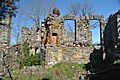
Gullian Gerig's Mill
Gullian Gerig's Mill, located on Beaver Valley Road in Glasgow, was added in 1987. Mills were very important in the past for grinding grain and other tasks. They show us how people used to produce food and goods.
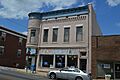
Morris Building
The Morris Building, at Washington and Green Streets in Glasgow, was listed in 1983. This building is an example of the kind of commercial buildings that were once common in town centers.
North Race Street Historic District
The North Race Street Historic District in Glasgow was recognized in 1983. This area includes many homes and buildings that show how people lived and worked in Glasgow's past.
Southwest Glasgow Residential District
The Southwest Glasgow Residential District is another important neighborhood in Glasgow, listed in 1983. It's a great example of a historic residential area, showing different styles of homes from earlier times.
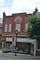
Third National Bank (Glasgow, Kentucky)
The Third National Bank building, at N. Green and Main Streets in Glasgow, was added to the list in 1983. Like the First National Bank, it's a reminder of Glasgow's financial history.
U.S. Post Office (Glasgow, Kentucky)
The U.S. Post Office and Board of Education Building in Glasgow was listed in 1983. Post offices were vital for communication, and this building shows the importance of public services in the community.
Wigwam Village 2
Wigwam Village No. 2, located near Cave City, Kentucky, is a very unique place! It was added to the National Register in 1988. It's a motel where the rooms are shaped like teepees or wigwams. It's a fun example of roadside architecture from the past.
| Name on the Register | Image | Date listed | Location | City or town | Description | |
|---|---|---|---|---|---|---|
| 1 | Belle's Tavern |
 |
(#87000169) |
Kentucky Route 255 37°05′30″N 86°02′59″W / 37.091667°N 86.049722°W |
Park City | |
| 2 | Ralph Bunche Historic District |
 |
(#04000247) |
Roughly bound by E. College St., Landrum St., Twyman Court, and S. Lewis St. 36°59′29″N 85°54′42″W / 36.991250°N 85.911529°W |
Glasgow | |
| 3 | Bybee House |
 |
(#12000444) |
3297 N. Jackson Highway 37°02′20″N 85°54′13″W / 37.038889°N 85.903611°W |
Glasgow | |
| 4 | Cave City Commercial District |
 |
(#83002529) |
Broadway between 1st and 2nd Sts. 37°08′18″N 85°57′31″W / 37.138333°N 85.958611°W |
Cave City | |
| 5 | Confederate Monument in Glasgow |
 |
(#97000717) |
Junction of Main and Green Sts. 36°59′44″N 85°54′45″W / 36.995556°N 85.9125°W |
Glasgow | |
| 6 | Charles Penn Edmunds House |
(#83002530) |
East of Becton 36°59′06″N 86°01′14″W / 36.985°N 86.020556°W |
Beckton | ||
| 7 | First National Bank |
 |
(#83002531) |
Main St. 36°59′47″N 85°54′46″W / 36.996389°N 85.912778°W |
Glasgow | |
| 8 | First Presbyterian Church |
 |
(#83002532) |
Washington and Broadway 36°59′40″N 85°54′40″W / 36.994306°N 85.911111°W |
Glasgow | |
| 9 | Fort Williams |
 |
(#75000732) |
Between Glasgow Municipal Cemetery and U.S. Route 31E 36°59′53″N 85°55′33″W / 36.998056°N 85.925833°W |
Glasgow | |
| 10 | Glasgow Central Business District |
 |
(#93000051) |
207 W. Main-117 E. Main, 100-114 S. Green, and 104 and 109 N. Race Sts.; also roughly bounded by Water St., Broadway St., Wayne St., and Liberty St. 36°59′46″N 85°54′44″W / 36.996111°N 85.912222°W |
Glasgow | Second group of addresses represents a boundary increase of February 11, 2004 |
| 11 | Glasgow OMS#9 |
(#02000922) |
Cavalry Dr. 36°58′50″N 85°56′06″W / 36.980556°N 85.935000°W |
Glasgow | ||
| 12 | Gullian Gerig's Mill |
 |
(#87002050) |
Beaver Valley Rd. 37°01′32″N 85°57′53″W / 37.025556°N 85.964722°W |
Glasgow | |
| 13 | William Hicks House |
(#83002533) |
Jeff Hicks Rd. 36°48′45″N 86°01′56″W / 36.8125°N 86.032222°W |
Austin | ||
| 14 | Landrum |
(#83002534) |
Kentucky Route 1318 36°52′56″N 85°56′05″W / 36.882222°N 85.934722°W |
Roseville | ||
| 15 | Benjamin Martin House |
(#83002535) |
Berry Store Rd. 36°55′44″N 86°07′34″W / 36.928889°N 86.126111°W |
Finney | ||
| 16 | John Mayfield House |
(#83002536) |
Southwest of Glasgow 36°59′06″N 85°58′54″W / 36.985°N 85.981667°W |
Glasgow | ||
| 17 | Andrew McCoy House |
(#83002537) |
Railroad Ave. 37°08′17″N 85°57′43″W / 37.138056°N 85.961944°W |
Cave City | ||
| 18 | Morris Building |
 |
(#83002538) |
Washington and Green Sts. 36°59′42″N 85°54′46″W / 36.995000°N 85.912639°W |
Glasgow | |
| 19 | North Race Street Historic District |
 |
(#83002539) |
N. Race St. between Front and Cherry Sts.; also roughly bounded by Happy Valley Rd., Green St., Garmon Ave. and Front St. 37°00′03″N 85°54′35″W / 37.000833°N 85.909722°W |
Glasgow | Second group of addresses represents a boundary increase |
| 20 | Octagon Cottage |
(#83002540) |
Off Kentucky Route 1297 36°58′10″N 86°02′44″W / 36.969444°N 86.045556°W |
Rocky Hill | ||
| 21 | Old Zion Methodist Church |
(#83002541) |
Kentucky Route 1297 36°59′00″N 86°03′53″W / 36.983333°N 86.064722°W |
Park City | ||
| 22 | William Page House |
(#83002542) |
South of Glasgow off Kentucky Route 249 36°54′51″N 85°55′18″W / 36.914167°N 85.921667°W |
Glasgow | ||
| 23 | G.F. Quigley and Son Grocery |
(#83002544) |
Off U.S. Route 31E 37°05′34″N 85°52′50″W / 37.092778°N 85.880556°W |
Goodnight | ||
| 24 | Renfro Hotel |
(#83002543) |
S. Dixie Ave. 37°05′31″N 86°02′53″W / 37.091944°N 86.048056°W |
Park City | ||
| 25 | Franklin Settle House |
(#83002545) |
Kentucky Routes 252 and 255 36°56′13″N 86°04′14″W / 36.936944°N 86.070556°W |
Rocky Hill | ||
| 26 | Site Bn-54 |
(#83002546) |
Roseville Rd. 36°54′52″N 85°55′17″W / 36.914444°N 85.921389°W |
Bristletown | Located on the Rora Brown farm: One and one-half story double pen log house. It has fantastic late Federal mantles and chairrail and wainscoting in right pen-later trim in the left pen. Step shouldered brick end chimneys flank the i block and the rear. | |
| 27 | Southwest Glasgow Residential District |
 |
(#83002547) |
Green St. between Cottage and College Sts., Leslie Ave., Liberty, Brown, and Washington Sts.; also roughly bounded by Washington St., Broadway St., Brookdale Dr., Cottage Ave., and Jefferson St. 36°59′15″N 85°55′12″W / 36.987500°N 85.920000°W |
Glasgow | Second group of addresses represents a boundary increase |
| 28 | Third National Bank |
 |
(#83002548) |
N. Green and Main Sts. 36°59′45″N 85°54′42″W / 36.995972°N 85.911667°W |
Glasgow | |
| 29 | U.S. Post Office/Board of Education Building |
 |
(#83002549) |
202 W. Washington St. 36°59′44″N 85°54′50″W / 36.995417°N 85.913750°W |
Glasgow | |
| 30 | Jesse and Simon White House |
(#83002550) |
Off U.S. Route 31E 36°52′45″N 86°01′27″W / 36.879167°N 86.024167°W |
Lucas | ||
| 31 | Wigwam Village No. 2 |
 |
(#88000180) |
Northwestern side of U.S. Route 31W, 1.6 miles (2.6 km) northeast of its junction with Kentucky Route 70 37°08′41″N 85°56′43″W / 37.144722°N 85.945278°W |
Cave City | |
| 32 | William Johnson Wood House |
(#83002551) |
East of Hiseville 37°05′46″N 85°45′46″W / 37.096111°N 85.762778°W |
Hiseville | ||
| 33 | Joseph Wooten House |
(#83002552) |
Crabtree Rd. 36°50′13″N 85°47′40″W / 36.836944°N 85.794444°W |
Tracy | ||
| 34 | Asa E. Young House |
(#83002553) |
Off Kentucky Route 921 36°47′50″N 85°55′42″W / 36.797222°N 85.928333°W |
Tracy |
Images for kids
-
Belle's Tavern
-
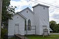
Johnston Chapel CME in the Ralph Bunche Historic District
-
The Bybee House
-
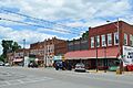
Broadway in Cave City
-

Confederate Monument in Glasgow
-
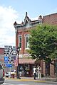
First National Bank of Glasgow
-
Glasgow First Presbyterian Church
-
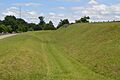
Fort Williams ditch
-
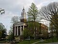
Barren County Kentucky courthouse
-
Gullian Gerig's Mill
-
Morris Building in Glasgow
-
North Race Street Historic District in Glasgow
-

South Green Street Glasgow Kentucky
-
Third National Bank of Glasgow
-

Glasgow USPS, Board of Education
-

Wigwam Village Motel
