
Geography of Poland facts for kids
 |
|
| Continent | Europe |
|---|---|
| Region | North European Plain |
| Coordinates | 52°00′N 20°00′E / 52.000°N 20.000°E |
| Area | Ranked 69th |
| • Total | 312,696 km2 (120,733 sq mi) |
| • Land | 98.52% |
| • Water | 1.48% |
| Coastline | 770 km (480 mi) |
| Borders | 3,582 km (2,226 mi) |
| Highest point | Rysy, 2,499 meters (8,199 ft) |
| Lowest point | Raczki Elbląskie, −1.8 meters (−6 ft) |
| Longest river | Vistula, 1,047 km (651 mi) |
| Largest lake | Lake Śniardwy, 113.4 km2 (43.8 sq mi) |
| Climate | temperate climate |
| Terrain | swamps, level terrain, hills, mountains |
| Natural resources | coal, sulfur, copper, silver, natural gas, iron, zinc, lead, salt, arable land |
| Exclusive economic zone | 30,533 km2 (11,789 sq mi) |
| Maps of Poland | |
|---|---|
| Topography | |
| Major agglomerations | |

Interactive map with links to articles
|
|
| Provinces and highways | |
 |
|
| Satellite photo by NASA Landsat 7 | |
 |
|
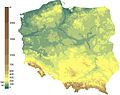
| Hypsometry | |
 |
|
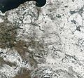
| Satellite photo, winter 2003 | |

Snow cover in mid-winter
|
Poland (Polish: Polska) is a country in Europe. It stretches from the Sudetes and Carpathian Mountains in the south to the sandy beaches of the Baltic Sea in the north. Poland is the fifth-most populated country in the European Union. It is also the ninth-largest country in Europe by size.
Poland covers about 312,696 km2 (120,733 sq mi). Most of this area (98.52%) is land, and a small part (1.48%) is water. The Polish coastline is about 770 km (478 mi) long. The highest point in Poland is Mount Rysy, which is 2,501 m (8,205 ft) tall.
Poland has many different types of land. While the middle of the country is mostly flat, you can find lots of lakes, rivers, hills, swamps, beaches, islands, and forests. The Baltic coast has two natural harbours. The biggest one is near Gdańsk and Gdynia. The smaller one is close to Szczecin in the northwest.
In the northeast, there is the Masurian Lake District. This area has more than 2,000 lakes. It is also very wooded and not many people live there. South of the lake district, and across central Poland, are wide plains. These plains reach all the way to the Sudetes mountains in the southwest. They also extend to the Carpathians in the southeast. These central lowlands were shaped by glaciers during the Pleistocene ice age.
Poland's longest and most important river is the Vistula. It is 1,047 kilometres (651 miles) long and is the ninth-longest river in Europe. Other important rivers are the Warta (808.2 km (502.2 mi)) and the Oder (742 km (461 mi)). Poland's largest lake is Śniardwy, covering 113.4 km2 (43.8 sq mi). The second largest is Mamry, which is 104 km2 (40 sq mi).
Contents
- Poland's Diverse Landscape
- Poland's Geological Features
- Land Use and Protected Areas
- Wildlife and Nature
- Rivers and Lakes
- Poland's Climate
- How Poland is Divided (Political Geography)
- Historical Regions of Poland
- Quick Facts and Figures
- Natural Resources and Land Use
- Environmental Concerns
- Images for kids
- See also
Poland's Diverse Landscape
Poland stretches 649 kilometres (403 mi) from north to south and 689 kilometres (428 mi) from east to west. Its total area is 312,696 square kilometres (120,733 sq mi), including its inland waters. The average height of the land is 173 metres (568 ft). Only 3% of Poland's land, along its southern border, is higher than 500 metres (1,600 ft). The highest peak is Mount Rysy, which is 2,499 metres (8,199 ft) high. It is part of the Tatra Mountains in the Carpathian Mountains, located south of Kraków. About 63 square kilometres (24 sq mi) of land along the Gulf of Gdańsk is actually below sea level. Poland also has an exclusive economic zone of 30,533 square kilometres (11,789 sq mi) in the Baltic Sea. This is an area where Poland has special rights to explore and use marine resources.
Main Land Regions
Poland is usually divided into five main land regions from north to south.
The largest region is the central lowlands, also called the "Polish Plain" (Polish: Niż Polski). This area is narrow in the west but gets wider as it goes east. It is very flat. Old glacial lakes here have been filled in with dirt and sand over time. Several major rivers flow through this region. These include the Oder (Odra) in the southwest and the Vistula (Polish: Wisła) in east-central Poland.
South of the lowlands are the Lesser Poland uplands. This is a belt of land between 90 kilometres (56 mi) and 200 kilometres (120 mi) wide. It is made up of gently sloping hills that lead to the Sudeten and Carpathian mountains. In the western part of this area, called the Silesia-Kraków Upthrust, there are rich coal deposits.
The third main land area is along Poland's southern border. It is formed by the Sudeten and Carpathian mountain ranges. These mountains are not so high that people cannot live there. The Carpathians are not very crowded. The Sudeten range has a rugged shape from old geological changes. Its highest point is Śnieżka (1,602 metres (5,256 ft)) in the Karkonosze Mountains. The Carpathians in Poland are the highest mountains in the country. They are the northern edge of a much larger mountain range that goes into other countries like the Czech Republic and Slovakia. In Poland, the Carpathians have two large basins, Oświęcim and Sandomierz. These areas are rich in minerals and natural gas.
North of the central lowlands is the lake region. This area includes the Białowieża Forest, which is one of the last remaining ancient forests in Europe. Glaciers shaped this region, creating lakes and low hills in the otherwise flat land near Lithuania and the Baltic Sea. Many small lakes are found across the northern half of Poland. The glacial features extend far inland in western Poland. Wide river valleys divide the lake region into three parts. In the northwest, Pomerania is located south of the Baltic coast. Masuria covers the rest of northern Poland and has many large lakes. Most of Poland's 9,300 lakes that are larger than 10,000 square metres (110,000 sq ft) are in this northern lake region. They cover about 10% of the land here.
The Baltic coastal plains are a low-lying area. They were formed by sand and dirt left behind by the sea. The coastline was shaped as the sea level rose after the Scandinavian ice sheet melted. The two main inlets on the smooth coast are the Pomeranian Bay near the German border and the Gulf of Gdańsk in the east. The Oder River flows into the Pomeranian Bay, and the Vistula River forms a large delta at the head of the Gulf of Gdańsk. Sandbars with big dunes create lagoons and coastal lakes along much of the coast.
Poland's Geological Features

Poland's geology has been shaped by two main things. First, the collision of the European and African continents over the last 60 million years. Second, the Quaternary glaciers that covered northern Europe. Both of these events helped form the Sudetes and the Carpathian Mountains. The northern part of Poland has soils made mostly of sand or loam from glaciers. The old ice age river valleys in the south often have loess, which is a type of fine, fertile soil.
The Kraków-Częstochowa Upland, the Pieniny, and the Western Tatras are made of limestone. The High Tatras, the Beskids, and the Karkonosze mountains are mostly made of hard rocks like granite and basalt. The Polish Jura Chain is one of the oldest mountain ranges on Earth.

Poland has 70 mountains that are over 2,000 metres (6,600 feet) high. All of these are in the Tatras. The Polish Tatras, which include the High Tatras and the Western Tatras, are the highest mountains in Poland and in the entire Carpathian range. Poland's highest point, the northwestern summit of Rysy, is in the High Tatras. It is 2,501 metres (8,205 ft) high. At the foot of Rysy are mountain lakes like Czarny Staw pod Rysami (Black Lake below Mount Rysy) and Morskie Oko (the Marine Eye).
The second highest mountain group in Poland is the Beskids. Their highest peak is Babia Góra, at 1,725 metres (5,659 ft). The next highest mountains are the Karkonosze in the Sudetes. Their highest point is Śnieżka, at 1,603 metres (5,259 ft). The Śnieżnik Mountains have a highest point of Śnieżnik, at 1,425 metres (4,675 ft).
Tourists also like to visit the Bieszczady Mountains in the far southeast of Poland. The highest point there is Tarnica, at 1,346 metres (4,416 ft). Other popular mountains are the Gorce Mountains in Gorce National Park, with Turbacz at 1,310 metres (4,298 ft). The Pieniny National Park in the Pieniny Mountains has Trzy Korony as its highest point at 982 metres (3,222 ft). The lowest point in Poland is at Raczki Elbląskie, near Elbląg in the Vistula Delta. It is 2 metres (6.6 ft) below sea level.

Poland has one desert called the Błędów Desert. It is located in southern Poland and covers 32 square kilometres (12 sq mi). It is one of only five natural deserts in Europe. It is also the warmest desert at this latitude. The Błędów Desert was formed thousands of years ago by a melting glacier. The sand layer is usually 40 metres (131 ft) thick, but can be up to 70 metres (230 ft). This allowed water to drain away quickly, helping to create the desert.
The Baltic Sea has created sand dunes in Słowiński National Park. Over time, these dunes separated the bay from the sea. Waves and wind move the sand inland, causing the dunes to slowly shift. They move at a speed of 3 to 10 metres (9.8 to 32.8 ft) per year. Some dunes are very high, up to 30 metres (98 ft). The highest point in the park, Rowokol (115 metres or 377 feet above sea level), is a great spot for viewing.
Land Use and Protected Areas

Poland is the fourth most forested country in Europe. Forests cover about 30.5% of Poland's land. This percentage is still growing. The forests are managed by the National Program of Reforestation. This program aims to increase forest coverage to 33% by 2050. Polish forests are very rich, with more than twice the average amount of trees compared to other European countries. The largest forest area in Poland is the Lower Silesian Wilderness.
More than 1% of Poland's land, which is 3,145 square kilometres (1,214 sq mi), is protected within 23 Polish national parks. Three more national parks are planned for Masuria, the Kraków-Częstochowa Upland, and the eastern Beskids. Also, wetlands along lakes and rivers in central Poland are protected by law. Coastal areas in the north are also protected. There are over 120 areas called landscape parks, plus many nature reserves and other protected areas.
Today, Poland is a good country for farming. It has over two million private farms. Poland is the top producer of potatoes and rye in Europe. It is also the world's largest producer of triticale, which is a mix of wheat and rye. Poland is an important producer of barley, oats, sugar beets, flax, and various fruits. It is also the European Union's fourth largest supplier of pork.
Wildlife and Nature

In terms of plants, Poland is part of the Central European area within the Boreal Kingdom. This means it has plants typical of northern parts of the world. According to the World Wide Fund for Nature, Poland has three main types of natural areas. These include continental forests, mixed forests, and mountain conifer forests.

Many animals that have disappeared from other parts of Europe still live in Poland. For example, the wisent (European bison) can be found in the ancient woodland of the Białowieża Forest. Other animals include the brown bear in Białowieża, the Tatras, and the Beskids. You can also find the gray wolf and the Eurasian lynx in various forests. Moose live in northern Poland, and beavers are found in Masuria, Pomerania, and Podlaskie.
In the forests, you can also see game animals like red deer, roe deer, and wild boars. Eastern Poland has many ancient forests, like Białowieża Forest, that have never been cut down by people. There are also large forested areas in the mountains, Masuria, Pomerania, and Lower Silesia.
Poland is a very important place for many European migratory birds to breed. One quarter of all the white storks in the world (40,000 breeding pairs) live in Poland. They especially like the lake districts and wetlands along the Biebrza, Narew, and Warta rivers. These areas are part of nature reserves or national parks.
Rivers and Lakes

Poland's longest rivers are the Vistula (Polish: Wisła), which is 1,047 kilometres (651 mi) long. The Oder (Polish: Odra) forms part of Poland's western border and is 854 kilometres (531 mi) long. Its branch, the Warta, is 808 kilometres (502 mi) long. The Bug, another branch of the Vistula, is 772 kilometres (480 mi) long. The Vistula and the Oder both flow into the Baltic Sea, as do many smaller rivers in Pomerania.
The Łyna and the Angrapa flow to the Baltic Sea through the Pregolya river. The Czarna Hańcza flows into the Baltic through the Neman. Most of Poland's rivers drain into the Baltic Sea. However, some rivers in Poland's Beskids mountains are the source of branches of the Orava. This river flows through the Váh and the Danube to the Black Sea. The eastern Beskids also have streams that flow through the Dniester to the Black Sea.
Poland's rivers have been used for travel and trade for a very long time. For example, the Vikings traveled up the Vistula and Oder rivers in their longships. In the Middle Ages, when Poland was a major producer of grain for Europe, shipping grain and other farm products down the Vistula to Gdańsk was very important.

Poland has almost ten thousand closed bodies of water that are larger than 1 hectare (2.47 acres) each. This means Poland has one of the highest numbers of lakes in the world. In Europe, only Finland has more lakes per area. The largest lakes, covering more than 100 square kilometres (39 sq mi), are Lake Śniardwy and Lake Mamry in Masuria. Also, Lake Łebsko and Lake Drawsko in Pomerania are very large.
Besides the lake regions in the north, there are also many mountain lakes in the Tatras. The Morskie Oko is the largest lake in the Tatras. The deepest lake in Poland is Lake Hańcza. It is more than 100 metres (328 ft) deep. It is located in the Wigry Lake District, east of Masuria.

Some of the first lakes where people settled were in the Greater Polish Lake District. The stilt house settlement of Biskupin was built before 700 BC. It was home to over a thousand people. Lakes have always been important in Polish history. The ancestors of today's Poles, the Polanie, built their first forts on islands in these lakes. The legendary Prince Popiel ruled from a tower in Kruszwica on Lake Gopło. The first ruler of Poland, Duke Mieszko I, had his palace on an island in the Warta River in Poznań. Today, Polish lakes are popular for water sports like yachting and wind-surfing.

The Polish Baltic coast is about 528 kilometres (328 mi) long. It stretches from Świnoujście in the west to Krynica Morska in the east. Poland's coastline is mostly smooth. It has been shaped by the constant movement of sand by currents and winds. This movement has created cliffs, dunes, and spits. Many of these have moved inland, closing off old lagoons like Łebsko Lake in Słowiński National Park.
Before the end of Second World War and the changes in national borders, Poland had only a very small coastline. This was at the end of the 'Polish Corridor', which was the only way Poland could reach the sea. After World War II, Poland's borders changed, giving it a much larger coastline. This allowed Poland to have much better access to the sea. This event was very important for Poland's future as an industrial country. It was even celebrated in 1945 as the Wedding to the Sea.
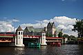
The largest sand spits are Hel Peninsula and the Vistula Spit. The largest Polish Baltic island is Wolin. The biggest sea harbours are Szczecin, Świnoujście, Gdańsk, Gdynia, Police, and Kołobrzeg. Popular coastal resorts include Świnoujście, Międzyzdroje, Kołobrzeg, Łeba, Sopot, Władysławowo, and the Hel Peninsula.
River Systems

Almost all of Poland's water flows north into the Baltic Sea. This happens through the Vistula, the Oder, and their branches. About half of the country is drained by the Vistula, which starts in the Silesian Beskids in south-central Poland.
The Vistula Basin covers most of the eastern half of Poland. It is drained by many rivers that mostly join the Vistula from the east. One of these branches, the Bug, forms 280 kilometres (170 mi) of Poland's eastern border with Ukraine and Belarus.
The Oder River and its main branch, the Warta, along with a few smaller rivers, form a basin that drains the western third of Poland into the Bay of Szczecin. However, in many parts of Poland, especially in the lake region and the areas south of it, water does not drain very well. This is because of the many swamplands, flat areas, and small, shallow lakes.
Poland's rivers have two high-water periods each year. The first is in spring, when melting snow and ice add water to the lowland rivers. The second is in July, caused by heavy rains.
Poland's Climate

.jpg)
Poland's weather changes a lot because different air masses meet over the country. Air from the sea moves across Western Europe. Cold air from the North Atlantic Ocean sweeps down. Warm air from the South Atlantic Ocean also arrives. Cold polar air is present for much of the year. But when it mixes with warmer air, it usually makes temperatures milder. This also brings a lot of rain, clouds, and fog. If these warmer influences are not there, winter temperatures in mountain valleys can drop to as low as −20 °C (−4 °F).
Spring arrives slowly in March or April. It brings mostly sunny days after a period of mixed winter and spring weather. Summer lasts from June to August. It is usually less humid than winter. Showers and thunderstorms happen, but they are mixed with dry, sunny weather. This sunny weather occurs when winds come from the south and east. Early autumn is generally sunny and warm. Then, a period of rainy, colder weather in November starts the change into winter. Winter can last from one to three months. It brings frequent snowstorms but not a lot of total snow.

The average temperatures range from 6 °C (42.8 °F) in the northeast to 10 °C (50 °F) in the southwest. However, temperatures in different regions of Poland vary a lot by season. On the highest mountain peaks, the average temperature is below 0 °C (32 °F). The Baltic coast, especially near Świnoujście and Szczecin, has cooler summers and warmer winters. This is because of the moderating west winds. The other temperature extreme is in the southeast, near the border with Ukraine. Here, the biggest seasonal differences happen. Winter temperatures average 4.5°C lower than in western Poland. The hottest cities in Poland are Tarnów, Wrocław, and Słubice.
.JPG)
Average temperatures are rising in Poland. From 1980 to 2010, there were 19 Decembers without snow. From 2000 to 2010, there were seven. December 2006 was the warmest December in Poland since 1779. In most of Poland, average temperatures rose by 3-5 degrees Celsius over the last thirty years.
The average yearly rainfall for the whole country is 600 mm (23.6 in). But some mountain areas get as much as 1,300 mm (51.2 in) per year. The total rainfall is a bit higher in the southern uplands than in the central plains. A few areas, like along the Vistula between Warsaw and the Baltic Sea, get less than 500 mm (19.7 in). In winter, about half the rain in the lowlands and all the rain in the mountains falls as snow. On average, summer rainfall is twice that of winter. This provides a good water supply for crops. The growing season is about 40 days longer in the southwest than in the northeast, where spring arrives later.
|
|
|
||||||||||||||||||||||||||||||||||||||||||||||||||||||||||||||||||||||||||||||||||||||||||||||||||||||||||||||||||||||||||||||||||||||||||||||||||||||||||||||||||||||||||||||||||||||||||||||||||||||||||||||||||||||||||||||||||||||||||||||||||||||||||||||||||||||||||||||||||||||||||||||||
| Climate data for Poland | |||||||||||||
|---|---|---|---|---|---|---|---|---|---|---|---|---|---|
| Month | Jan | Feb | Mar | Apr | May | Jun | Jul | Aug | Sep | Oct | Nov | Dec | Year |
| Record high °C (°F) | 18.9 (66.0) |
22.1 (71.8) |
25.6 (78.1) |
32.5 (90.5) |
36.2 (97.2) |
38.3 (100.9) |
40.2 (104.4) |
39 (102) |
36.8 (98.2) |
28.9 (84.0) |
26.2 (79.2) |
20.4 (68.7) |
40.2 (104.4) |
| Record low °C (°F) | −41 (−42) |
−40.6 (−41.1) |
−34.7 (−30.5) |
−21.8 (−7.2) |
−9 (16) |
−4.6 (23.7) |
−5.5 (22.1) |
−3.2 (26.2) |
−9.2 (15.4) |
−18.5 (−1.3) |
−29 (−20) |
−40 (−40) |
−41 (−42) |
The highest temperature ever recorded in Poland was 40.2 °C (104.4 °F) on July 29, 1921, in Prószków. The lowest temperature ever recorded was −41 °C (−42 °F) on January 11, 1940, in Siedlce. The highest winter temperature was 25.6 °C (78.1 °F) on March 20, 2021. The lowest summer temperature was −5.5 °C (22.1 °F) on July 21, 1996. On January 1, 2022, Warsaw had a temperature of 18.9 °C (66.0 °F), which was the highest ever recorded in January. New Year's Eve night was also one of the warmest winter nights in history, with temperatures reaching 17 °C (63 °F) in Słubice around midnight.
How Poland is Divided (Political Geography)
Poland is divided into areas called voivodeships, which are like provinces. These are mostly based on Poland's old historical regions. In the past, these areas were named after individual cities. The new voivodeships vary in size. Opole Voivodeship is smaller than 10,000 square kilometres (3,900 sq mi), while Masovian Voivodeship is larger than 35,000 square kilometres (14,000 sq mi).
At the voivodeship level, power is shared. There is a governor (called a voivode) chosen by the government. There is also an elected regional assembly (called a sejmik). This assembly then chooses an executive group to run things.
Voivodeships are further divided into powiats, which are like counties. These counties are then divided into gminas, also known as communes or municipalities. Large cities usually have the status of both a gmina and a powiat. Poland has 16 voivodeships, 379 powiats (including 65 cities that are also powiats), and 2,478 gminas.
|
||||||||||||||||||||||||||||||||||||||||||||||||||||||
Historical Regions of Poland

Within Poland's current borders, you can find these historical regions:
- Greater Poland (Wielkopolska)
- Kuyavia (Kujawy)
- Lesser Poland (Małopolska) with parts of Red Ruthenia
- Lithuania Minor (Litwa Mniejsza), only a small part is in Poland
- Lubusz Land (Ziemia Lubuska)
- Lusatia (Łużyce), a smaller part is in Poland, a larger part in Germany
- Masovia (Mazowsze)
- Masuria (Mazury)
- New March (Nowa Marchia), partly in Poland, historically part of Brandenburg
- Podlaskie (Podlasie)
- Pomerania (Pomorze)
- Pomerelia (Pomorze Gdańskie)
- Prussia (Prusy), only partly in modern Poland, also a German historical region
- Silesia (Śląsk), also extends into parts of the Czech Republic and Germany.
- Warmia (Ermland)
Quick Facts and Figures
- Area compared to other countries: Poland is slightly larger than Oman.
- Land borders: The total length of Poland's land borders is 2,888 km (1,795 mi).
- Countries bordering Poland and their lengths:
- Belarus: 416 km (258 mi)
- Czech Republic: 790 km (490 mi)
- Germany: 467 km (290 mi)
- Lithuania: 103 km (64 mi)
- Russia (via Kaliningrad Oblast): 210 km (130 mi)
- Slovakia: 541 km (336 mi)
- Ukraine: 528 km (328 mi)
- Coastline: 770 km (480 mi).
- Maritime claims: Poland has an exclusive economic zone of 30,533 square kilometres (11,789 sq mi). This area is defined by international agreements.
- Territorial sea: 12 nmi (22.2 km; 13.8 mi) (this is the part of the sea closest to the coast that a country fully controls).
- Highest and lowest points:
- Lowest point: Raczki Elbląskie at −1.8 m (−5.9 ft) below sea level.
- Highest point: Rysy at 2,499 m (8,199 ft) above sea level.
- Sea islands: Wolin, eastern part of Uznam (Usedom).
Natural Resources and Land Use
- Natural resources: Poland has many natural resources. These include coal, sulfur, copper, natural gas, iron, zinc, lead, salt, and good land for farming (arable land).
- Land use:
- arable land (land used for growing crops): 47%
- permanent crops (land with crops that are harvested over many years, like fruit trees): 15%
- permanent pastures (land for grazing animals): 13%
- Forests of Poland and woodlands: 29%
- Other land uses: 10% (as of 1993)
- Irrigated land: 1,000 square kilometres (390 sq mi) (as of 1993). This is land where water is supplied for farming.
- Important rivers: The main rivers are the Vistula (Wisła), Oder (Odra), Bug, Warta River, Narew, and San.
Environmental Concerns

Natural hazards: Poland sometimes experiences flooding.
National parks are important protected areas.
Current environmental issues: The environment in Poland has improved since 1989. This is because heavy industry has decreased, and governments have become more concerned about the environment. However, air pollution is still a serious problem. This is mainly due to sulfur dioxide released from coal-fired power plants. The resulting acid rain has damaged forests. Water pollution from factories and cities is also an issue, as is getting rid of hazardous waste. The country uses revegetation to help manage coal ash disposal. Studies show that certain bush species naturally help clean up fly ash dumps.
International environmental agreements: Poland is part of many international agreements to protect the environment. These include agreements on:
- Air Pollution
- Antarctic-Environmental Protocol
- Antarctic Treaty
- Biodiversity
- Climate Change
- Endangered Species
- Environmental Modification
- Hazardous Wastes
- Law of the Sea
- Marine Dumping
- Nuclear Test Ban
- Ozone Layer Protection
- Ship Pollution
- Wetlands
Poland has also signed, but not yet fully agreed to, agreements on:
- Air Pollution-Nitrogen Oxides
- Air Pollution-Persistent Organic Pollutants
- Air Pollution-Sulphur 1994
- Climate Change-Kyoto Protocol
Geography note: Historically, Poland has been an area of conflict. This is because of its flat land and lack of natural barriers on the North European Plain.
Images for kids
-
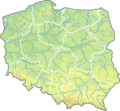
Topographic map of Poland
-
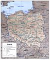
Provinces and highways map
-
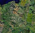
Satellite photo by NASA Landsat 7
-
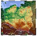
Hypsometry map of Poland
-
Satellite photo of Poland in winter 2003, showing snow cover
-
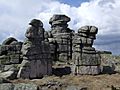
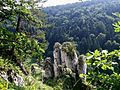
Granite outcrop Silesian Rocks at Karkonosze in the Sudetes, south-western Poland
-
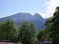
Giewont in the Tatra Mountains; the mountainous south is a popular destination for hikers
-
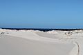
Dunes in Słowiński National Park
-
Forests of the Ojców National Park
-
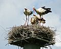
Family of white stork. Poland hosts the largest white stork population.
-
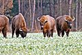
A herd of wisents in Białowieża Forest
-
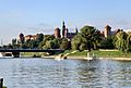
The Vistula river in Kraków
-
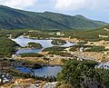
Kurtkowiec, oligotrophic lake in southeastern Poland
-
Lake Solina near Lesko in southeastern Poland
-
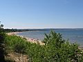
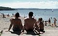
Baltic beaches of the Gdańsk Bay, one of Poland's popular destinations.
-
The Oder river in Szczecin
-

Köppen climate classification types of Poland
-
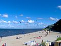
The average daytime summer temperature at sea level along the Baltic coast is 22 °C (71.6 °F). Bay of Puck (Zatoka Pucka)
-
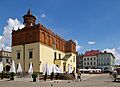
A sunny morning in Tarnów
-
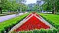
Summer in the Spa-Park in the resort of Świnoujście
-
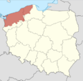
The historical Pomerania region in contemporary Poland
-
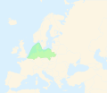
North European Plain colored in green.
See also
 In Spanish: Geografía de Polonia para niños
