Geography of Texas facts for kids
 |
|
| Region | South Central United States |
|---|---|
| Coordinates | 31°N 100°W / 31°N 100°W |
| Area | |
| • Total | 268,581 sq mi (695,620 km2) |
| Coastline | 367 mi (591 km) |
| Highest point | Guadalupe Peak, 8,749 feet (2,667 m) |
| Lowest point | Gulf of Mexico, sea level |
The geography of Texas is super varied and huge! Texas covers about 7% of the total land and water area of the United States. It's the second-largest state, right after Alaska. Texas is located in the South Central United States. People often think of it as part of both the U.S. South and the U.S. Southwest.
People in Texas often divide the state into different areas like North Texas, East Texas, Central Texas, South Texas, West Texas, and sometimes the Panhandle. But if you look at the land itself, Texas has four main natural regions: the Gulf Coastal Plains, Interior Lowlands, Great Plains, and Basin and Range Province. This shows how people see the state differently from how geographers describe its natural features. Texas is so big that some parts feel more like the Midwest, while others are like the American Southeast or the Southwest. For example, El Paso in West Texas is closer to New Mexico than to cities like Austin or Dallas.
Contents
Texas's Amazing Size and Features
Texas is a really big state, covering about 268,581 square miles (695,662 km²). It's so wide that if you travel from the far northwest corner to the very south near Brownsville, it's about 801 miles (1,289 km)! Going from east to west, it's about 773 miles (1,244 km) from the Sabine River to El Paso.
Because Texas is so huge, some cities are closer to cities in other states than to their own capital, Austin. For example, El Paso is closer to San Diego, California, than to Houston. Also, Dalhart in the Panhandle is closer to the capitals of Kansas, Nebraska, Colorado, New Mexico, Oklahoma, and Wyoming than it is to Austin!
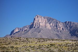
The middle of Texas is about 15 miles (24 km) northeast of Brady. The highest point in Texas is Guadalupe Peak, which is 8,749 feet (2,667 meters) above sea level. The lowest point is at sea level along the Gulf of Mexico. Texas has many state forests and 120 state parks, covering over 605,000 acres (2,448 km²). There are also 3,700 named streams and 15 major river systems. These rivers flow for over 191,000 miles (307,389 km) and fill more than 212 reservoirs.
Texas has 10 different climate regions, 14 types of soil regions, and 11 unique ecological regions. This means the state has a huge variety of land, weather, and plant and animal life!
Texas Coast and Estuaries
Texas has about 367 miles (591 km) of coastline along the Gulf of Mexico. Many barrier islands run along this coast. These islands create calm areas called estuaries, where rivers meet the ocean. These estuaries are very important for nature and the economy of Texas. They are home to many different plants and animals.
Coastal Plains Region
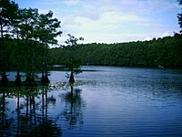
The Gulf Coastal Plains stretch from the Gulf of Mexico far inland. This big area includes cities like Paris, San Antonio, and Del Rio. It gets about 20 to 58 inches (508 to 1,473 mm) of rain each year. The land is mostly flat and drained by rivers flowing into the coastal estuaries and marshes. You can find sandy areas, grasslands, and salt marshes near the sea. Important national parks here include Big Thicket National Preserve, Padre Island National Seashore, and the Palo Alto Battlefield National Historic Site.
North Central Plains Region
The North Central Plains are bordered by the Caprock Escarpment to the west and the Edwards Plateau to the south. This region includes areas around Abilene and Wichita Falls. It gets about 35 to 50 inches (889 to 1,270 mm) of rain each year. The land is gently rolling and has forests with oaks, hickories, elm, and gum trees. The soils here can be sandy or made of clay and shale.
Great Plains Region
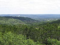
The Great Plains region includes the Llano Estacado, the Panhandle, and the Edwards Plateau. It's bordered by the Caprock Escarpment to the east. Cities in this area include Midland, Odessa, Lubbock, and Amarillo. The Hill Country is a popular name for the hilly area that connects the Great Plains and the Gulf Coastal Plains.
This region gets about 15 to 31 inches (381 to 787 mm) of rain each year. The southern part of the Great Plains has rolling grasslands and shrubs. It's also home to amazing places like Caprock Canyons and Palo Duro Canyon state parks. The Southern High Plains of Texas has the most playa lakes in the world, with nearly 22,000!
Texas's blackland prairies were some of the first places farmed in the state. These areas have dark, rich clay soils, which are great for farming. National Parks in this area include the Lyndon B. Johnson National Historical Park and the San Antonio Missions National Historical Park.
Mountains and Basins Region
The Trans-Pecos region, also known as the Mountains and Basins, gets less than 12 inches (305 mm) of rain each year. This is the most complex natural region in Texas. It has sand dunes, desert valleys, wooded mountain slopes, and desert grasslands. This area is west of the Pecos River and includes the Davis Mountains. It's the only part of Texas that is truly mountainous, with seven peaks taller than 8,000 feet (2,438 meters).
This region has a huge variety of plants, including at least 268 types of grass and 447 types of woody plants. National Parks here include Big Bend National Park and Guadalupe Mountains National Park. This area is part of the Chihuahuan Desert.
Texas Climate

Texas has three main climates: Continental, Mountain, and Modified Marine. The Modified Marine, or subtropical, climate covers most of the state. The amount of rain Texas gets each year varies a lot, from about 60.57 inches (1,538 mm) in East Texas to only 9.43 inches (240 mm) in El Paso.
The hottest temperature ever recorded in Texas was 120°F (49°C) in Seymour in 1936 and Monahans in 1994. The coldest temperature was -23°F (-31°C) in Tulia in 1899 and Seminole in 1933.
Texas Geology
Texas is mostly made of sedimentary rocks. East Texas has layers of sediments from the Cretaceous period and later, which show where ancient shorelines used to be. These layers sit on top of older rocks that formed when mountains pushed together a long time ago. West of these old mountains, the rocks are from the Permian and Triassic periods.
Oil is found in the Cretaceous rocks in the east, the Permian rocks in the west, and along the Gulf coast. There are also some very old Precambrian igneous and metamorphic rocks in the central and western parts of the state. In far West Texas, near the Big Bend area, you can find Oligocene volcanic rocks. A thick layer of Miocene sediments, called the Ogallala formation, in the western high plains is an important source of groundwater. Texas does not have active volcanoes and rarely has earthquakes because it's far from where Earth's plates meet. The Big Bend area has the most earthquakes, but they are usually small and don't cause much damage.
Texas Resources
Texas has many natural resources, making it a big state for farming and industry. It produces a lot of oil, cattle, sheep, and cotton. The state also produces poultry, eggs, dairy products, wheat, rice, sugar cane, peanuts, and various fruits and vegetables.
Here are some of the natural resources found in Texas:
- Asphalt: Found in rocks, mainly limestone, in counties like Bexar and Uvalde.
- Cement: Produced in many counties, including Dallas and Houston. Texas usually makes about 10% of the cement in the U.S.
- Clay: Texas is one of the top producers of different types of clays.
- Coal: Bituminous coal is found in central Texas counties. Lignite, or brown coal, is found in the Texas Coastal Plain.
- Fluorspar: An important mineral used to make steel, aluminum, and glass. It's found in the Trans-Pecos and Llano regions.
- Gemstones: People enjoy collecting agate, jasper, topaz, opal, and petrified wood in Texas.
- Graphite: Found in the Llano region.
- Guano: Bat guano (bat droppings) is found in many caves in the Edwards Plateau.
- Gypsum: Found in large amounts in West Texas and along the Gulf Coast.
- Helium: Texas is the leading producer of helium in the U.S., from a gas field near Amarillo.
- Iron Ore: Deposits are found in northeastern and central Texas.
- Rare-earth elements: These special elements are found in some rocks in the Trans-Pecos area.
- Limestone: Very common in Texas and used to make lime.
- Magnesium salts: Found in West Texas.
- Manganese: Found in various counties like Mason and Val Verde.
- Mica: Found in the Llano region.
- Opal: Common opal is found on the Texas Coastal Plain.
- Salt: Found in large amounts in salt domes along the Texas Coastal Plain and in West Texas.
- Sand: Used for industrial purposes and found in many parts of Texas.
- Silver: Silver mining started in the late 1880s in Presidio County. Texas produced a lot of silver between 1885 and 1955.
- Sulfur: Found in salt domes along the Gulf Coastal Plain and in West Texas.
- Uranium: In the past, uranium was mined in several counties, but all uranium mines are now closed.
- Natural Gas: The Barnett Shale in the Fort Worth basin is a big source of natural gas.
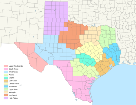
Texas Regions
There are many ways to describe the different parts of Texas, based on their land, geology, and even culture. These regions often overlap. Here are some of the accepted regions in Texas:
- Alamo: An economic region.
- Big Bend: A sub-region in the south of the Trans-Pecos area, along the Rio Grande.
- Blackland Prairies: A natural region stretching between North Texas and the Alamo region.
- Brazos Valley: Seven counties in Central Texas.
- Canadian River Valley: Around a river in Northwest Texas.
- Central Texas: One of the regions used by the Texas Comptroller. It overlaps with Texas Hill Country.
- Concho Valley: A sub-region of West Texas.
- Coastal Bend: A curved part of Texas's Gulf Coast.
- Cross Timbers
- East Texas
- Edwards Plateau
- Gulf Coast: Can mean an economic region or the entire coastline.
- Llano Estacado
- North Texas
- Northeast Texas
- Northwest Texas: An economic region.
- Permian Basin
- Piney Woods
- Red River Valley
- Rio Grande Valley
- South Plains: Part of the Llano Estacado.
- South Texas
- Southeast Texas
- Texas Hill Country
- Texas Panhandle: Also known as the High Plains.
- Texas Urban Triangle
- Trans-Pecos
- West Texas
Geographical Regions that Extend into Texas
Some larger regions of the United States also include parts of Texas:
- Southwestern United States
- Southern United States
- Deep South
- Black Belt
- Great Plains
- Chihuahuan Desert
- High Plains
- Piney Woods
See also
 In Spanish: Geografía de Texas para niños
 | Misty Copeland |
 | Raven Wilkinson |
 | Debra Austin |
 | Aesha Ash |


