
Cordillera Central (Puerto Rico) facts for kids
Quick facts for kids Cordillera Central |
|
|---|---|

Cordillera Central runs through the municipality of Corozal, among others in central Puerto Rico.
|
|
| Highest point | |
| Peak | Cerro de Punta |
| Elevation | 4,390 ft (1,340 m) |
| Geography | |

Cordillera Central
Location in Puerto Rico
|
|
| Location | |
| State/Province | Caribbean |
The Cordillera Central (which means Central Mountain Range in English) is the main mountain range in Puerto Rico. It stretches across the island from west to east. This mountain range acts like a natural wall, dividing Puerto Rico into its northern and southern flat coastal areas.
The Cordillera Central starts in the western town of Maricao. It then goes eastward through the middle of the island to Aibonito. From there, it continues southeast towards the Caribbean Sea, forming a part called the Sierra Cayey. The Cordillera Central includes its main part and many smaller mountain groups, hills, and ridges all over the island. Cerro de Punta is the tallest peak in the Cordillera Central. It is also the highest point in all of Puerto Rico! The Sierra de Luquillo, where El Yunque rainforest is, is sometimes thought of as an extension of this mountain range.
Contents
A Look at the Past: How the Mountains Shaped History
The Cordillera Central area has been home to people for a very long time. Even before Spanish explorers arrived, the Taíno people lived here. Different Taíno groups, called cacicazgos or chiefdoms, likely shared this mountainous region. When the Spanish came to Puerto Rico, many Taínos found safety in these central mountains. Today, you can still find many old Taíno sites here.
These mountains have always been important for Puerto Rico's economy. The cool climate is perfect for growing fruits, vegetables, and especially coffee. Coffee farming grew a lot in the 1800s. This helped the mountain towns grow and attracted many new people. Immigrants came from coastal cities like San Juan and Ponce. People also came from Europe, encouraged by a special rule called the Royal Decree of Graces of 1815. This rule made it easier for non-Spanish Europeans to settle and farm the land. Coffee became a very profitable business, especially for Corsican immigrants.
The first paved road to cross the mountains was the Carretera Central. It was finished in 1898. This road connected San Juan on the Atlantic coast to Ponce on the Caribbean coast. Many workers helped build it, including some Chinese workers from Cuba. This road was the most important building project by the Spanish government in Puerto Rico during the 1800s. It greatly changed how people lived and traveled in the region. The original road is now a historic site in the US. It was also known as the Military Road because it was important for armies. Both the Spanish and US armies used it during the Spanish-American War in 1898.
Exploring the Geography of the Central Mountains
The Cordillera Central is the biggest of Puerto Rico's three main land regions. It starts in the west, near towns like Maricao and Mayagüez. Sometimes, the Santa Marta Hills in the southwest are also included. These hills separate two valleys: the Lajas Valley and the Guanajibo Valley.
The main part of the Cordillera Central continues eastward. It goes through many towns like Jayuya, Villalba, and Aibonito. This section has the highest peaks in Puerto Rico, including Cerro de Punta. The Aibonito Pass is a natural break that separates the main Cordillera Central from its eastern part, the Sierra de Cayey. The Sierra de Cayey crosses towns like Cayey and Guayama. From there, the range splits into two smaller ridges that end near the southeastern coast of Puerto Rico.

The Sierra de Luquillo is often seen as part of the Cordillera Central. However, it is actually separated by a large river basin and other natural features.
-
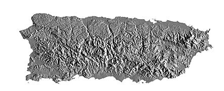
Relief map with the Cordillera Central.
-
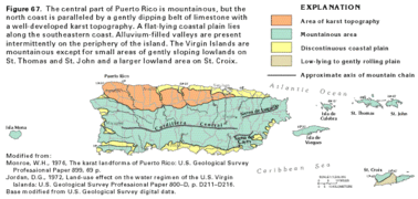
Physiographic map of the geographic provinces.


How the Mountains Were Formed: Geology
The Cordillera Central was formed over millions of years. It happened because the North American and Caribbean tectonic plates slowly moved and crashed into each other. This movement caused the land to fold and rise, like an accordion.
Besides these plate movements, volcanoes also helped create the mountains. About 120 million years ago, during the Early Cretaceous period, this area had many small volcanic islands. What we see as the Cordillera Central today used to be the tops of these ancient islands.
Because of its volcanic past, most of the rocks here are from old volcanic eruptions. There are also rocks formed from sediments and some deeper rocks like quartz diorite. In the western part, you can find metamorphic rocks, which are rocks changed by heat and pressure.
Nature's Home: Ecology
The Cordillera Central is a very special place for plants and animals. Many species found here live nowhere else in the world! Most of the area is covered in Puerto Rican moist forests. These are like tropical jungles and are part of the tropical and subtropical moist broadleaf forest ecoregion of the Caribbean.
Plants of the Mountains
The Cordillera Central has different types of forests. These include tropical mountain forests, which have cloud forests and dwarf forests. Trees in the middle parts of the mountains are usually the tallest. Trees closer to the mountain tops tend to be smaller.
Some common trees you might see are the West Indian treefern, the trumpet tree, and the candlewood or tabonuco tree. You can also find the Puerto Rican magnolia and the Sierra palm tree. The lower hills have plants like the coroso palm tree. Many of the endangered plant species are found only here. These include the Cordillera maiden fern and Cook's holly. Some trees like the Caribbean pine and mahogany have been brought here and have adapted well.
Animals of the Mountains
This region is home to many unique animals, especially birds and amphibians. Besides the common coqui frog, there are at least 10 other types of coqui frogs here. Some of these are endangered.
Reptiles you might find include the Puerto Rican ground lizard and the blind worm lizard. The endangered Puerto Rican boa and the Puerto Rican racer snake also live here. Common birds include the Puerto Rican woodpecker, the Puerto Rican tody, and the Puerto Rican emerald hummingbird. The Puerto Rican parrot used to be common but is now critically endangered. Other endangered birds are the Puerto Rican broad-winged hawk and the Puerto Rican sharp-shinned hawk.
The rivers and streams in the mountains are home to fish like the mountain mullet and gata shrimp. Several types of bats also live here, such as the Antillean ghost-faced bat. Unfortunately, some animals like the small Indian mongoose and black rat have been introduced and are a threat to the native species.
Special Protected Areas
The Cordillera Central has most of Puerto Rico's protected state forests. These areas help protect the unique nature of the mountains:
- Carite
- Cerrillos
- Guilarte
- Los Tres Picachos
- Maricao (Monte del Estado)
- Monte Choca
- Pueblo
- Susúa
- Toro Negro
Mountain Weather: Climate
The Cordillera Central stretches from west to east, creating a natural border for the island's weather. These tall mountains block the easterly winds that bring rain. This creates a "rain shadow" effect. Because of this, the southern plains are drier and more like a desert, while the northern part of the island is more tropical and humid.
The Cordillera Central is one of the rainiest places in Puerto Rico, second only to the Sierra de Luquillo. The most rain falls between May and December, which is also the hurricane season. The months from December to March are usually the driest.
Some of the coldest temperatures in Puerto Rico have been recorded in the mountain towns. The lowest temperature ever recorded was 38°F (3°C) in Aibonito in March 1911. It has also been 40°F (4°C) in Adjuntas in 1966 and 1993. Because of the warm climate, it is impossible for it to snow in the Cordillera Central or anywhere else in Puerto Rico.
Highest Peaks in the Cordillera Central

Here are some of the highest mountain peaks in the Cordillera Central, including those in the Sierra de Cayey.
| Rank | Mountain Peak | Municipality and (Barrio) | Location Reference |
Elevation | Elevation Reference |
|---|---|---|---|---|---|
| 1 | Cerro de Punta | Ponce (Anón) | 4,357 ft (1,328 m) | ||
| 2 | Monte Jayuya | Jayuya (Saliente), Ponce (Anón) | 4,252 ft (1,296 m) | ||
| 3 | Cerro Rosa | Ciales (Toro Negro), Jayuya (Saliente) | 4,144 ft (1,263 m) | ||
| 4 | Piedra Blanca | Jayuya (Veguitas) | 4,042 ft (1,232 m) | ||
| 5 | Cerro Maravilla | Ponce (Anón) | 3,960 ft (1,207 m) | ||
| 6 | Monte Guilarte | Adjuntas (Guilarte) | 3,934 ft (1,199 m) | ||
| 7 | Los Tres Picachos | Ciales (Toro Negro), Jayuya (Coabey) | 3,894 ft (1,187 m) | ||
| 8 | Cerro Saliente | Jayuya (Saliente) | 3,845 ft (1,172 m) | ||
| 9 | Monte Membrillo | Yauco (Río Prieto) | 3,579 ft (1,091 m) | ||
| 10 | Cerro El Bolo | Orocovis (Ala de la Piedra), Villalba (Villalba Arriba) | 3,527 ft (1,075 m) | ||
| 11 | Cerro Doña Juana | Orocovis (Ala de la Piedra) | 3,471 ft (1,058 m) | ||
| 12 | Cerro Vaquiña | Adjuntas (Guilarte) | 3,369 ft (1,027 m) | ||
| 13 | Cerro Garrote | Peñuelas (Rucio) | 3,356 ft (1,023 m) | ||
| 14 | Cerrote de Peñuelas | Peñuelas (Rucio) | 3,307 ft (1,008 m) | ||
| 15 | Cerro El Gigante | Adjuntas (Saltillo) | 3,175 ft (968 m) | ||
| 16 | Cerro Morales | Jayuya (Jayuya Abajo), Utuado (Tetuán) | 3,126 ft (953 m) | ||
| 17 | Las Tres Palmas | Jayuya (Coabey) | 3,106 ft (947 m) | ||
| 18 | La Torrecilla | Barranquitas (Barrancas) | 3,057 ft (932 m) | ||
| 19 | Cerro Roncador | Utuado (Guaonico) | 3,038 ft (926 m) | ||
| 20 | Peña La Francia | Orocovis (Bauta Abajo) | 3,028 ft (923 m) | ||
| 21 | Cerro Prieto | Utuado (Viví Arriba) | 3,021 ft (921 m) | ||
| 22 | Cerro El Malo | Orocovis (Bermejales) | 3,005 ft (916 m) | ||
| 23 | Cerro Taita | Orocovis (Bauta Abajo) | 2,985 ft (910 m) | ||
| 24 | Cerro Novillo | Adjuntas (Portillo) | 2,952 ft (900 m) | ||
| 25 | Cerro La Santa | Caguas (San Salvador), Cayey (Farallón), San Lorenzo (Espino) | 2,903 ft (885 m) | ||
| 26 | Cerro Palo de Café | Jayuya (Mameyes Arriba) | 2,896 ft (883 m) | ||
| 27 | Cerro El Peligro | Guayanilla (Jagua Pasto, Quebrada Honda), Peñuelas (Macaná) | 2,890 ft (880 m) | ||
| 28 | Cerro Lloroso | Adjuntas (Tanamá, Yayales) | 2,883 ft (879 m) | ||
| 29 | Pico Rodadero | Yauco (Aguas Blancas, Duey, Sierra Alta) | 2,864 ft (873 m) | ||
| 30 | Cerro Pío | Orocovis (Damián Arriba, Saltos) | 2,841 ft (866 m) | ||
| 31 | Cerro Lucero | Caguas (San Salvador), Cayey (Farallón) | 2,831 ft (863 m) | ||
| 32 | Monte Hormiga | Adjuntas (Capáez) | 2,831 ft (863 m) | ||
| 33 | Cerro Medina | Adjuntas (Tanamá, Yayales) | 2,824 ft (861 m) | ||
| 34 | Cerro de La Tabla | Cayey (Jájome Alto), Guayama (Carite, Guamaní) | 2,808 ft (856 m) | ||
| 35 | Cerro Honoré | Patillas (Muñoz Rivera), San Lorenzo (Espino) | 2,795 ft (852 m) | ||
| 36 | Cerro Avispa | Cayey (Cercadillo) | 2,778 ft (847 m) | ||
| 37 | Cerro Magoyo | Jayuya (Mameyes Arriba) | 2,762 ft (842 m) | ||
| 38 | Cerro Las Tetas | Salinas (Lapa) | 2,759 ft (841 m) | ||
| 39 | Cerro La Chorrera | Adjuntas (Capáez), Utuado (Guaonico) | 2,739 ft (835 m) | ||
| 40 | Cerro Pulguillas | Coamo (Pulguillas) | 2,739 ft (835 m) | ||
| 41 | Cerro Curet | Yauco (Aguas Blancas) | 2,690 ft (820 m) | ||
| 42 | Cerro Mata de Plátano | Peñuelas (Jaguas) | 2,673 ft (815 m) | ||
| 43 | Monte El Gato | Cayey (Sumido) | 2,673 ft (815 m) | ||
| 44 | Cerro Garzas | Adjuntas (Garzas) | 2,641 ft (805 m) | ||
| 45 | Peña Domingo | Cayey (Pasto Viejo, Piedras) | 2,637 ft (804 m) | ||
| 46 | Cerro Don Quiño | Adjuntas (Yahuecas, Yayales) | 2,621 ft (799 m) | ||
| 47 | Cerro El Pico | Coamo (Pulguillas) | 2,598 ft (792 m) | ||
| 48 | Peñon de los Soldados | Cayey (Cercadillo), Salinas (Palmas) | 2,552 ft (778 m) | ||
| 49 | Cerro Mercado | Adjuntas (Portillo, Yahuecas) | 2,532 ft (772 m) | ||
| 50 | Cerro Farallón | Barranquitas (Quebradillas) | 2,552 ft (778 m) |
Images for kids
-
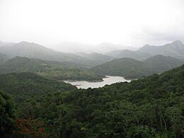
Cordillera Central and tabonuco forest in Sabana Grande.
-
View of the Cordillera from the north in Piletas, Lares.
-
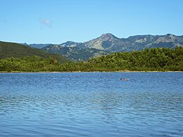
Yauco Lake reservoir.
-
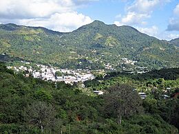
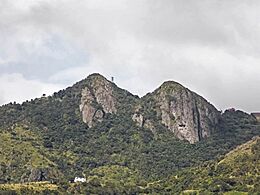
Adjuntas Pueblo and El Gigante Dormido.
-
Cordillera Central from Guayanilla Bay.
-
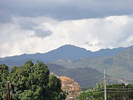
Cerro de Punta, Puerto Rico's highest peak, from downtown Ponce.
-
Cerro Las Tetas in Salinas close to the Aibonito Pass.
-
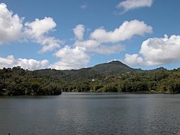
Sierra de Cayey from Patillas Lake.
-
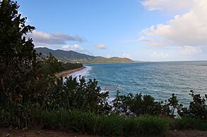
View of Sierra de Guardarraya, the easternmost end of the Cordillera Central physiographic province, from Punta Tuna, Maunabo.


.jpg)


See also
 In Spanish: Cordillera Central (Puerto Rico) para niños
