Inner Banks facts for kids
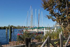
The Inner Banks is a name created by people who develop land and promote tourism. It describes the inland coastal area of eastern North Carolina. This name is fairly new, from the early 2000s. It helps make this farming region more appealing to tourists and people who want to retire there.
Contents
What is the Inner Banks Region?
The Inner Banks region was once known as the Piney Woods. This was around the time of the US Civil War. People from this area were sometimes called "Goobers." Over time, these old names were used less as forests were cut down.
The name "Inner Banks" suggests a connection to the Outer Banks. The Outer Banks are a chain of barrier islands off the coast of North Carolina. They have been a popular place for tourists for a long time.
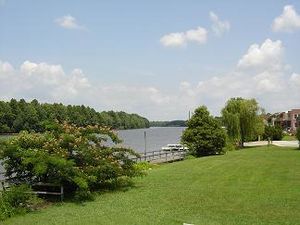
Many people want to buy land near the water in eastern North Carolina. They want to build second homes there. This has made waterfront property much more expensive. For example, a piece of land by the Trent River might be worth a lot more than a similar piece of land just across the road.
People who promote tourism say the Inner Banks covers a large area. It is about 22,227 square miles (57,568 km²). This area has over 3,000 miles of coastline along rivers and sounds. About 2.5 million people live here. The Inner Banks includes regions like the Crystal Coast and Albemarle. The area has a mild climate. It is becoming a popular place for people to retire. It also attracts small business owners. Sometimes, "Inner Banks" is shortened to IBX.
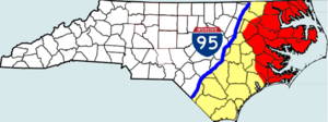
The Inner Banks generally stretches from Interstate 95 in the west to the Outer Banks in the east. It goes from the Virginia border down to the South Carolina border. This region includes 41 counties. It is three times bigger than the state of New Jersey. Some areas farther from the sounds and rivers are not usually called part of the Inner Banks. Eastern North Carolina used to rely on farming and textile factories. Now, it is working to find new ways to grow its economy.
Six small towns in the Inner Banks are working together. They call their effort the Creative Communities Initiative. They want to create places that attract artists and other creative people. These towns are: Ayden, Edenton, Hertford, Murfreesboro, Plymouth, and Tarboro.
Albemarle Region
Northeastern North Carolina is also called the Albemarle Region. It has 16 counties in the very northeast of North Carolina. These counties surround Albemarle Sound and its rivers, like the Chowan and Roanoke. This area has many beautiful, undeveloped beaches, rivers, and small towns. You can find historic places along the Historic Albemarle Tour.
History of the Albemarle Region
This region has many waterways. For thousands of years, different groups of indigenous peoples lived here. When Europeans arrived, Algonquian-speaking tribes mainly lived along the coast. Other major language groups in the state were Siouan languages and Iroquoian languages.
After Europeans came, this area was one of the first in North America to be settled by English people. Virginia Dare was born on nearby Roanoke Island in 1587. This is now part of North Carolina. She was the first English child born in North America. However, the Roanoke colony did not survive.
From the 1600s until the American Civil War, farmers grew tobacco and cotton. These crops needed a lot of work. Plantation owners brought thousands of enslaved Africans to work their fields. This continued until 1808, when the Atlantic slave trade was stopped. Enslaved people and their descendants were very important to the success of North Carolina. Tobacco wore out the soil quickly. Some early tobacco farmers started growing different crops by the late 1700s to help their land recover.
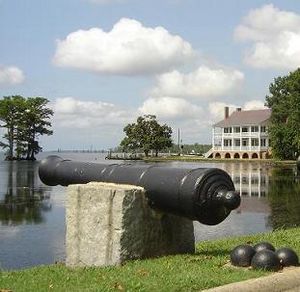
Most white farmers in the region were quite successful until the American Civil War. The good farmland and shipping businesses became targets for the Union during the war. Several towns were burned by Union troops. These included Plymouth and Winton. At Plymouth, Confederate forces used an ironclad warship for the first time. It was called the CSS Albemarle.
After the war, the region's economy changed slowly. It continued to rely on farming. However, farming faced difficulties through the late 1800s.
Counties of the Inner Banks
Here are some of the counties usually considered part of the Inner Banks:
- Beaufort County
- Bertie County
- Camden County
- Carteret County
- Chowan County
- Craven County
- mainland Currituck County
- mainland Dare County
- eastern Edgecombe County
- Gates County
- eastern Halifax
- Hertford County
- mainland Hyde County
- eastern Jones County
- Martin County
- Northampton County
- eastern Onslow County
- Pamlico County
- Pasquotank County
- Perquimans County
- Pitt County
- Tyrrell County
- Washington County
- Wayne County
Cities and Towns in the Inner Banks
Here are some of the towns and communities in the Inner Banks:
- Ahoskie
- Ayden
- Arapahoe
- Aurora
- Bath
- Bayboro
- Beaufort
- Belhaven
- Bethel
- Camden
- Chocowinity
- Columbia
- Corapeake
- Creswell
- Currituck
- Edenton
- Elizabeth City
- Eure
- Eureka
- Farmville
- Fremont
- Gates
- Gatesville
- Greenville
- Goldsboro
- Grifton
- Hampstead
- Harkers Island
- Havelock
- Hertford
- Hobbsville
- Jacksonville
- Knotts Island
- Morehead City
- Moyock
- Murfreesboro
- New Bern
- Newport
- Oak City
- Oriental
- Pantego
- Plymouth
- Robersonville
- Roducco
- Roper
- Stantonsburg
- Sunbury
- Swan Quarter
- Swansboro
- Tarboro
- Trenton
- Vanceboro
- Washington
- Williamston
- Windsor
- Winfall
- Winterville
- Winton
Parks to Visit
The Inner Banks region has several state parks where you can explore nature:
Wildlife Refuges
These special areas protect animals and their homes:
- Alligator River National Wildlife Refuge
- Cedar Island National Wildlife Refuge
- Great Dismal Swamp National Wildlife Refuge
- Mattamuskeet National Wildlife Refuge
- Pocosin Lakes National Wildlife Refuge
- Roanoke River National Wildlife Refuge
- Swanquarter National Wildlife Refuge
Colleges and Universities
Here are some of the colleges and universities in the Inner Banks area:
- Chowan University
- East Carolina University
- Elizabeth City State University
- Mid-Atlantic Christian University
- Beaufort County Community College
- Carteret Community College
- Coastal Carolina Community College
- College of the Albemarle
- Craven Community College
- Edgecombe Community College
- Halifax Community College
- Martin Community College
- Pamlico Community College
- Pitt Community College
- Roanoke-Chowan Community College
div col end}}


