
Greater Western Sydney facts for kids
Quick facts for kids Greater Western SydneyNew South Wales |
|||||||||||||||
|---|---|---|---|---|---|---|---|---|---|---|---|---|---|---|---|
   .jpg)   From top, bottom to right: Parramatta skyline; Suburban neighbourhood in Prestons; Western Sydney Parklands; Stadium Australia; Boothtown Aqueduct; Liverpool at night
|
|||||||||||||||
 |
|||||||||||||||
| State electorate(s) | Several | ||||||||||||||
| Federal Division(s) | Blaxland, Chifley, Fowler, Greenway, Hughes, Lindsay, Macarthur, McMahon, Mitchell, Parramatta, Werriwa | ||||||||||||||
|
|||||||||||||||
Greater Western Sydney (GWS) is a big area in Greater Sydney, New South Wales (NSW), Australia. It covers the north-west, south-west, central-west, and far western parts of Sydney. It also includes the Blue Mountains.
This large region is made up of 11 different local government areas. These include Blacktown, Blue Mountains, Camden, and Parramatta.
Greater Western Sydney is also called "Western Sydney" by the NSW Government. It's a very important and growing part of Australia.
Scientists believe people have lived in the Sydney area for about 30,000 years. The Darug people lived in what is now Greater Western Sydney. They found lots of food from the rivers and forests.
Parramatta was founded in 1788, the same year as Sydney. This makes it Australia's second oldest city. Parramatta Road, opened in 1811, was Australia's first highway. It connected Sydney's main city area to Parramatta.
After World War II, many soldiers and new people settled here. This made Greater Western Sydney one of the most developed areas. It is now a very important region for Australia.
The region covers about 5,800 square kilometers. It has a fast-growing population, with over 2.2 million people in 2017. Greater Western Sydney has many different cultures. About 38% of people speak a language other than English at home. In some areas, this number is as high as 90%.
This region has about 9% of Australia's population. It also has 44% of Sydney's population. Most people here work in industries and trades.
Greater Western Sydney also has beautiful national parks and waterways. It has farms, natural bushland, and sports facilities. You can find rare Cumberland Plain Woodland here. The Blue Mountains are also a World Heritage-listed area.
The Hawkesbury and Nepean River provide Sydney's water. They are also important for farming and fishing. The Warragamba Dam, which supplies water to Sydney, is located here.
Contents
- History of Greater Western Sydney
- Geography of Greater Western Sydney
- Climate of Greater Western Sydney
- People and Culture in GWS
- Economy of Greater Western Sydney
- Transport in Greater Western Sydney
- Media in Greater Western Sydney
- Sports in Greater Western Sydney
- Education in Greater Western Sydney
- Landmarks to Explore
- Images for kids
History of Greater Western Sydney
Early Indigenous Life
Near Penrith, very old stone tools have been found. They are about 45,000 to 50,000 years old. Aboriginal people, like the Gandangara tribe, lived in the Fairfield area for over 30,000 years.
The Mulgoa tribe of the Dharug people lived near Penrith. They built simple huts and hunted animals like kangaroos. They also fished in the Nepean River. The Auburn area was a trading place for different Aboriginal groups.
Many native people sadly died from new diseases like smallpox. These diseases arrived after the First Fleet. The remaining people were often moved to special farms or settlements.
British Settlement and Growth


In 1788, Governor Arthur Phillip chose Parramatta for a large farm. This made it the second European settlement in Australia. The first settlement in Sydney Cove was not good for farming. So, many convicts were moved to Parramatta to grow food.
In 1793, the Auburn area became the first free farming settlement. Other areas like Prospect and Greystanes were settled later. In 1789, explorers found the wide Nepean River near Penrith.
Windsor Road, one of Sydney's oldest roads, opened in 1794. Early explorers also found good land along the Georges River. The first European settlement in the Fairfield area was recorded in 1795.
In 1797, a big battle happened in Parramatta. Pemulwuy, an Aboriginal leader, led warriors against a government farm. In 1804, Irish convicts rebelled in what is known as the Castle Hill convict rebellion.
Governor Lachlan Macquarie liked Parramatta's clean air. He made Old Government House, Parramatta into a beautiful home. This building is Australia's oldest public building. It became a World Heritage site in 2010.
Farms were set up in Riverstone and Smithfield in 1803. This was because of good water and land. Windsor is the fourth oldest British settlement in Australia. Farmers used its fertile river flats for crops.
Modern Urban Development

Liverpool Hospital was built by the Georges River. It is Australia's second oldest hospital. Fairfield railway station opened in 1856. It has the oldest railway building still standing in NSW.
Quarrying began in Prospect in the 1820s. Charles Darwin visited Prospect Hill in 1836 to study its geology. Prospect Reservoir was built in the 1880s for Sydney's water supply.
Lansvale was a popular place for fun in the early 1900s. During World War II, Bankstown Airport became an important air base. In the 1960s, Campbelltown was planned as a new city for Sydney's southwest.
Until the 1950s, Liverpool was a farming town. But as Sydney grew, Liverpool became a busy suburb. It has many factories and a strong working-class community. In the 1950s and 60s, Blacktown grew quickly. New suburbs appeared, and Blacktown Hospital opened in 1965.
Diverse Communities
In the 1960s and 70s, many people from Southeast Asia moved to Cabramatta. This was after the Vietnam War. Cabramatta became a lively Asian community. Also in the 1970s, many Middle Eastern people, especially from Lebanon, settled in Lidcombe and Bankstown.
Wonderland Sydney opened in 1985 in Eastern Creek. It was the biggest amusement park in the southern hemisphere. It closed in 2004. In 2015, many Assyrian people from the Middle East settled in Fairfield and Liverpool. They came to Australia seeking safety.
Geography of Greater Western Sydney
Landscape and Features

Greater Western Sydney stretches from Windsor in the north to Campbelltown in the south. It goes from Lidcombe in the east to Penrith and the Blue Mountains in the far west.
Most of Greater Western Sydney is on the Cumberland Plain. This area is quite flat. It is also a bit drier than the coast. This is because of a "rain shadow" effect from the Hills District.
However, there are some hilly areas. Western Sydney Parklands, one of the world's largest parklands, has hills. Prospect Hill is also a high point. It is the only place in Sydney with ancient volcanic activity.
Some suburbs are quite high up. These include Leppington and Oran Park in the southwest. Also, Pemulwuy and Horsley Park in the west are elevated.
Plants and Animals

The main plant types in Greater Western Sydney are grassy woodlands. These are like savannas with eucalyptus trees. There are also dry forests and some wet forests. About half of the native plants that were here before Europeans arrived still remain.
Many native birds, insects, reptiles, and mammals live here. You can often see them in urban areas. Birds like sparrows and mynas are common in city centers. Possums, bandicoots, lizards, snakes, and frogs can also be found.
Rocks and Rivers
.jpg)
The Sydney area sits on Triassic shales and sandstones. It has low hills and wide valleys. The soils in western Sydney are usually red and yellow. They are rich in clay and are acidic.
The Blue Mountains are made of sandstone. This sandstone was pushed up long ago. The center of the Sydney basin is under Fairfield.
The Prospect dolerite intrusion in Pemulwuy is Sydney's largest area of igneous rock. This oval-shaped ridge formed millions of years ago. Hot volcanic material moved up from deep inside the Earth.
Swamps and lagoons are found along the Nepean River. One example is Bents Basin, a popular swimming spot. The Parramatta River drains a large part of Sydney's western suburbs.
The Georges River drains the south and southwest of Sydney. It flows north from Appin, then east towards Botany Bay. Other waterways like South Creek and Prospect Creek also drain the area.
Climate of Greater Western Sydney
Greater Western Sydney has a humid subtropical climate. This means it has warm, humid summers and mild winters. Average high temperatures are around 23°C, and lows are around 12°C. The region is a few degrees warmer than Sydney's city center.
Summer temperatures average between 27°C and 32°C. Winter temperatures are mild, usually 15°C to 20°C. Spring and autumn are transition seasons. Spring often has bigger temperature changes than autumn.
Rainfall is spread out through the year. February to April tend to be wetter. July to December are usually drier. Thunderstorms are common in late summer and early autumn. Winters are cool and sunny, especially in August.
Most western suburbs get about 700 to 900 mm of rain each year. This is less than Sydney's city center, which gets about 1217 mm.
Sydney often experiences a "föhn effect." This is when winds from the Great Dividing Range warm up as they come down into the Sydney basin. This can make fire danger worse in warm months. Richmond has the biggest temperature range ever recorded in Australia. It has gone from -8.3°C to 47.8°C.
- Summer
Western Sydney is much hotter than Sydney city in summer. Daytime temperatures can be 5°C warmer. Sometimes, they can even be 10°C hotter. This is because cool sea breezes don't reach inland areas. Hot winds from the desert can raise temperatures above 40°C.
- Autumn
In early autumn, hot days are still possible. Temperatures can reach above 37°C in March. April is cooler, with days above 30°C happening rarely. Days cooler than 20°C become more common in May. May days are usually mild, from 17°C to 24°C. Nights start getting cooler, often falling below 10°C in April.
- Winter
Winter temperatures are usually mild, between 15°C and 20°C. Sometimes it can be cooler, around 10°C to 14°C. Winter nights average 6.9°C. A few nights a year, temperatures drop below 2°C, mostly in July. Nights below 0°C happen more often in far-western suburbs. These include Campbelltown and Penrith. Frost is also common in these areas.
- Spring
Spring temperatures change a lot. In September, it can reach above 30°C. Cool days below 15°C can also happen. October and November have big changes. Hot winds can push temperatures above 35°C, or even 40°C in November. But cool days below 20°C are also common. Nights in September can still fall below 5°C.
Climate data
| Climate data for Parramatta | |||||||||||||
|---|---|---|---|---|---|---|---|---|---|---|---|---|---|
| Month | Jan | Feb | Mar | Apr | May | Jun | Jul | Aug | Sep | Oct | Nov | Dec | Year |
| Record high °C (°F) | 45.5 (113.9) |
41.9 (107.4) |
40.5 (104.9) |
37.0 (98.6) |
29.2 (84.6) |
25.5 (77.9) |
25.9 (78.6) |
30.6 (87.1) |
35.4 (95.7) |
40.1 (104.2) |
42.7 (108.9) |
43.9 (111.0) |
45.5 (113.9) |
| Mean daily maximum °C (°F) | 28.4 (83.1) |
27.8 (82.0) |
26.2 (79.2) |
23.8 (74.8) |
20.5 (68.9) |
17.8 (64.0) |
17.3 (63.1) |
19.0 (66.2) |
21.6 (70.9) |
23.9 (75.0) |
25.4 (77.7) |
27.4 (81.3) |
23.3 (73.9) |
| Mean daily minimum °C (°F) | 17.5 (63.5) |
17.6 (63.7) |
15.8 (60.4) |
12.8 (55.0) |
9.9 (49.8) |
7.5 (45.5) |
6.2 (43.2) |
7.1 (44.8) |
9.3 (48.7) |
11.9 (53.4) |
14.0 (57.2) |
16.2 (61.2) |
12.2 (54.0) |
| Record low °C (°F) | 10.1 (50.2) |
9.2 (48.6) |
6.8 (44.2) |
4.0 (39.2) |
1.4 (34.5) |
0.8 (33.4) |
−1.0 (30.2) |
0.7 (33.3) |
0.7 (33.3) |
3.6 (38.5) |
4.0 (39.2) |
7.7 (45.9) |
−1.0 (30.2) |
| Average precipitation mm (inches) | 102.3 (4.03) |
126.0 (4.96) |
109.0 (4.29) |
89.8 (3.54) |
72.4 (2.85) |
86.2 (3.39) |
46.8 (1.84) |
54.4 (2.14) |
53.9 (2.12) |
69.1 (2.72) |
85.2 (3.35) |
70.9 (2.79) |
965.6 (38.02) |
| Average precipitation days | 12.0 | 12.1 | 12.5 | 9.2 | 9.9 | 10.5 | 8.2 | 7.9 | 8.0 | 10.3 | 11.6 | 10.3 | 122.5 |
| Climate data for Bankstown Airport | |||||||||||||
|---|---|---|---|---|---|---|---|---|---|---|---|---|---|
| Month | Jan | Feb | Mar | Apr | May | Jun | Jul | Aug | Sep | Oct | Nov | Dec | Year |
| Record high °C (°F) | 44.8 (112.6) |
43.3 (109.9) |
41.6 (106.9) |
36.9 (98.4) |
28.5 (83.3) |
25.4 (77.7) |
26.7 (80.1) |
30.2 (86.4) |
35.6 (96.1) |
39.7 (103.5) |
43.1 (109.6) |
43.6 (110.5) |
44.8 (112.6) |
| Mean daily maximum °C (°F) | 28.2 (82.8) |
27.8 (82.0) |
26.2 (79.2) |
23.7 (74.7) |
20.4 (68.7) |
17.7 (63.9) |
17.2 (63.0) |
18.9 (66.0) |
21.5 (70.7) |
23.7 (74.7) |
25.1 (77.2) |
27.3 (81.1) |
23.1 (73.6) |
| Mean daily minimum °C (°F) | 18.1 (64.6) |
18.1 (64.6) |
16.2 (61.2) |
12.7 (54.9) |
9.6 (49.3) |
6.6 (43.9) |
5.1 (41.2) |
6.0 (42.8) |
8.7 (47.7) |
11.8 (53.2) |
14.3 (57.7) |
16.6 (61.9) |
12.0 (53.6) |
| Record low °C (°F) | 10.4 (50.7) |
10.0 (50.0) |
7.8 (46.0) |
2.4 (36.3) |
1.3 (34.3) |
−1.9 (28.6) |
−4.0 (24.8) |
−0.7 (30.7) |
0.0 (32.0) |
4.4 (39.9) |
6.8 (44.2) |
6.3 (43.3) |
−4.0 (24.8) |
| Average precipitation mm (inches) | 90.3 (3.56) |
106.4 (4.19) |
97.7 (3.85) |
83.2 (3.28) |
71.1 (2.80) |
73.1 (2.88) |
44.6 (1.76) |
49.1 (1.93) |
44.7 (1.76) |
62.1 (2.44) |
77.2 (3.04) |
67.2 (2.65) |
867.0 (34.13) |
| Average precipitation days | 11.1 | 10.9 | 11.3 | 8.8 | 9.8 | 9.3 | 8.0 | 7.3 | 7.7 | 9.5 | 11.0 | 9.8 | 114.5 |
| Climate data for Prospect Reservoir | |||||||||||||
|---|---|---|---|---|---|---|---|---|---|---|---|---|---|
| Month | Jan | Feb | Mar | Apr | May | Jun | Jul | Aug | Sep | Oct | Nov | Dec | Year |
| Record high °C (°F) | 44.7 (112.5) |
42.5 (108.5) |
39.5 (103.1) |
37.1 (98.8) |
29.4 (84.9) |
25.6 (78.1) |
26.5 (79.7) |
29.4 (84.9) |
35.0 (95.0) |
39.0 (102.2) |
42.0 (107.6) |
42.7 (108.9) |
44.7 (112.5) |
| Mean daily maximum °C (°F) | 28.4 (83.1) |
27.9 (82.2) |
26.3 (79.3) |
23.6 (74.5) |
20.3 (68.5) |
17.3 (63.1) |
16.8 (62.2) |
18.7 (65.7) |
21.3 (70.3) |
23.7 (74.7) |
25.3 (77.5) |
27.5 (81.5) |
23.1 (73.6) |
| Mean daily minimum °C (°F) | 17.6 (63.7) |
17.7 (63.9) |
16.1 (61.0) |
13.0 (55.4) |
10.0 (50.0) |
7.4 (45.3) |
6.1 (43.0) |
6.8 (44.2) |
9.4 (48.9) |
12.1 (53.8) |
14.2 (57.6) |
16.4 (61.5) |
12.2 (54.0) |
| Record low °C (°F) | 10.0 (50.0) |
10.8 (51.4) |
7.9 (46.2) |
3.6 (38.5) |
1.2 (34.2) |
−0.8 (30.6) |
−0.6 (30.9) |
−0.5 (31.1) |
2.6 (36.7) |
4.5 (40.1) |
6.8 (44.2) |
7.8 (46.0) |
−0.8 (30.6) |
| Average precipitation mm (inches) | 93.7 (3.69) |
96.0 (3.78) |
95.6 (3.76) |
74.1 (2.92) |
72.0 (2.83) |
74.9 (2.95) |
57.0 (2.24) |
50.3 (1.98) |
47.1 (1.85) |
59.4 (2.34) |
72.4 (2.85) |
75.2 (2.96) |
868.1 (34.18) |
| Average precipitation days | 10.7 | 10.6 | 10.9 | 9.3 | 9.0 | 9.4 | 7.8 | 8.0 | 8.5 | 9.4 | 9.5 | 9.9 | 113.0 |
| Climate data for Richmond | |||||||||||||
|---|---|---|---|---|---|---|---|---|---|---|---|---|---|
| Month | Jan | Feb | Mar | Apr | May | Jun | Jul | Aug | Sep | Oct | Nov | Dec | Year |
| Record high °C (°F) | 47.8 (118.0) |
43.7 (110.7) |
41.9 (107.4) |
38.2 (100.8) |
30.0 (86.0) |
26.8 (80.2) |
27.6 (81.7) |
32.8 (91.0) |
35.9 (96.6) |
40.4 (104.7) |
43.6 (110.5) |
43.7 (110.7) |
47.8 (118.0) |
| Mean daily maximum °C (°F) | 30.0 (86.0) |
29.1 (84.4) |
26.8 (80.2) |
23.9 (75.0) |
20.6 (69.1) |
17.9 (64.2) |
17.4 (63.3) |
19.7 (67.5) |
22.7 (72.9) |
25.0 (77.0) |
26.7 (80.1) |
28.5 (83.3) |
24.0 (75.2) |
| Mean daily minimum °C (°F) | 17.6 (63.7) |
17.7 (63.9) |
15.6 (60.1) |
11.4 (52.5) |
7.6 (45.7) |
4.9 (40.8) |
3.6 (38.5) |
4.4 (39.9) |
8.0 (46.4) |
11.0 (51.8) |
14.1 (57.4) |
16.0 (60.8) |
11.0 (51.8) |
| Record low °C (°F) | 8.9 (48.0) |
6.4 (43.5) |
3.9 (39.0) |
−0.4 (31.3) |
−2.4 (27.7) |
−6.7 (19.9) |
−8.3 (17.1) |
−4.0 (24.8) |
−1.4 (29.5) |
1.7 (35.1) |
3.7 (38.7) |
5.0 (41.0) |
−8.3 (17.1) |
| Average precipitation mm (inches) | 78.5 (3.09) |
125.8 (4.95) |
74.2 (2.92) |
48.9 (1.93) |
52.4 (2.06) |
48.0 (1.89) |
31.2 (1.23) |
30.7 (1.21) |
49.7 (1.96) |
52.8 (2.08) |
83.5 (3.29) |
61.6 (2.43) |
738.5 (29.07) |
| Source 1: (averages and records) | |||||||||||||
| Source 2: (records only) | |||||||||||||
| Climate data for Camden Airport | |||||||||||||
|---|---|---|---|---|---|---|---|---|---|---|---|---|---|
| Month | Jan | Feb | Mar | Apr | May | Jun | Jul | Aug | Sep | Oct | Nov | Dec | Year |
| Record high °C (°F) | 46.4 (115.5) |
43.2 (109.8) |
41.0 (105.8) |
38.5 (101.3) |
27.5 (81.5) |
24.9 (76.8) |
25.4 (77.7) |
30.2 (86.4) |
36.0 (96.8) |
40.5 (104.9) |
42.6 (108.7) |
43.1 (109.6) |
46.4 (115.5) |
| Mean daily maximum °C (°F) | 29.5 (85.1) |
28.6 (83.5) |
26.7 (80.1) |
23.8 (74.8) |
20.5 (68.9) |
17.7 (63.9) |
17.2 (63.0) |
19.0 (66.2) |
21.9 (71.4) |
24.1 (75.4) |
26.1 (79.0) |
28.4 (83.1) |
23.6 (74.5) |
| Mean daily minimum °C (°F) | 16.8 (62.2) |
16.8 (62.2) |
14.8 (58.6) |
11.0 (51.8) |
7.0 (44.6) |
4.5 (40.1) |
3.0 (37.4) |
3.8 (38.8) |
6.7 (44.1) |
9.9 (49.8) |
12.9 (55.2) |
15.1 (59.2) |
10.2 (50.4) |
| Record low °C (°F) | 7.9 (46.2) |
7.2 (45.0) |
5.9 (42.6) |
−0.7 (30.7) |
−2.2 (28.0) |
−5.4 (22.3) |
−6.0 (21.2) |
−4.0 (24.8) |
−1.8 (28.8) |
1.3 (34.3) |
3.8 (38.8) |
5.7 (42.3) |
−6.0 (21.2) |
| Average precipitation mm (inches) | 77.9 (3.07) |
100.9 (3.97) |
85.8 (3.38) |
66.9 (2.63) |
57.4 (2.26) |
59.0 (2.32) |
38.7 (1.52) |
42.4 (1.67) |
39.6 (1.56) |
65.3 (2.57) |
77.0 (3.03) |
54.9 (2.16) |
767.3 (30.21) |
| Average precipitation days (≥ 0.2 mm) | 10.1 | 10.9 | 10.3 | 9.2 | 8.7 | 8.7 | 8.1 | 7.6 | 7.9 | 9.8 | 10.6 | 9.0 | 110.9 |
| Average relative humidity (%) | 49 | 52 | 52 | 52 | 52 | 53 | 50 | 43 | 44 | 47 | 50 | 46 | 49 |
| Climate data for Holsworthy Control Range | |||||||||||||
|---|---|---|---|---|---|---|---|---|---|---|---|---|---|
| Month | Jan | Feb | Mar | Apr | May | Jun | Jul | Aug | Sep | Oct | Nov | Dec | Year |
| Record high °C (°F) | 45.7 (114.3) |
41.7 (107.1) |
38.5 (101.3) |
33.6 (92.5) |
27.7 (81.9) |
24.9 (76.8) |
24.8 (76.6) |
28.9 (84.0) |
35.0 (95.0) |
3.7 (38.7) |
5.0 (41.0) |
7.0 (44.6) |
−4.0 (24.8) |
| Mean daily maximum °C (°F) | 29.1 (84.4) |
28.3 (82.9) |
26.3 (79.3) |
23.5 (74.3) |
20.5 (68.9) |
17.8 (64.0) |
17.3 (63.1) |
19.1 (66.4) |
22.3 (72.1) |
24.1 (75.4) |
25.5 (77.9) |
27.4 (81.3) |
23.4 (74.1) |
| Mean daily minimum °C (°F) | 17.5 (63.5) |
17.5 (63.5) |
15.5 (59.9) |
12.1 (53.8) |
8.1 (46.6) |
6.2 (43.2) |
4.9 (40.8) |
5.4 (41.7) |
8.4 (47.1) |
10.8 (51.4) |
13.8 (56.8) |
15.7 (60.3) |
11.3 (52.3) |
| Record low °C (°F) | 9.2 (48.6) |
10.8 (51.4) |
6.6 (43.9) |
2.8 (37.0) |
−2.0 (28.4) |
−2.6 (27.3) |
−4.0 (24.8) |
−2.0 (28.4) |
0.8 (33.4) |
— | — | — | −4.0 (24.8) |
| Average precipitation mm (inches) | 59.5 (2.34) |
113.7 (4.48) |
67.4 (2.65) |
54.8 (2.16) |
53.8 (2.12) |
69.1 (2.72) |
43.1 (1.70) |
37.6 (1.48) |
32.6 (1.28) |
52.2 (2.06) |
73.7 (2.90) |
56.6 (2.23) |
709.4 (27.93) |
| Average precipitation days (≥ 0.1mm) | 8.7 | 10.3 | 11.1 | 11.2 | 10.0 | 10.6 | 10.1 | 7.4 | 7.5 | 9.5 | 11.9 | 10.5 | 118.8 |
| Average relative humidity (%) | 50 | 56 | 55 | 53 | 52 | 53 | 49 | 44 | 43 | 48 | 51 | 50 | 50 |
People and Culture in GWS
Languages Spoken

People in Greater Western Sydney come from over 170 countries. They speak more than 100 different languages. About 12% of new residents are still learning English.
Cabramatta has the highest number of people from non-English speaking backgrounds in Australia. This is about 87.7% of its population. Other suburbs like Fairfield and Bankstown also have over 80%.
Many people here were born in Australia. But Greater Western Sydney is still a big place for new arrivals. Between 2006 and 2011, 60% of new immigrants settled here. Most came from India, China, Iraq, the Philippines, and Vietnam.
Greater Western Sydney also has a large Indigenous Australian community. It is bigger than those in South Australia or Victoria.
Here are some of the largest groups of non-English speakers in Western Sydney:
- 62% of Assyrian Neo-Aramaic speakers
- 45% of Arabic speakers
- 29% of Vietnamese speakers
- 28% of Filipino/Tagalog speakers
- 33% of Hindi speakers
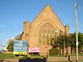
Religious Beliefs
Western Sydney is known for being a very religious area in Sydney. It has a high number of people who follow a faith. This is especially true in areas like Liverpool, Fairfield, and Bankstown.
Many people here are Christian, especially Catholic and Anglican. Suburbs like Bossley Park and Abbotsbury have over 80% Christians.
Some suburbs have many Islamic followers. These include Lakemba and South Granville.
Buddhism is common in suburbs like Cabramatta and Canley Vale. Hinduism is the main religion in Harris Park and Westmead.
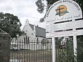
-
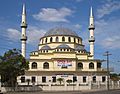
Auburn Gallipoli Mosque
-
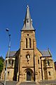
St Patrick's Cathedral
-
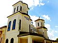
Assyrian Church of the East in Greenfield Park
-
Buddhist temple in Bonnyrigg
-
Arabic Baptist Church in Old Guildford
-
St Mary's Anglican Church in Guildford

St_Patricks_Cathedral_Parramatta-1.jpg)


Community Life and Growth
Parramatta is the main city center in Greater Western Sydney. Other local areas are also growing fast. They offer more jobs and diverse environments.
In the early 2010s, areas like Camden, Campbelltown, and Penrith saw lots of new buildings. Parramatta and Blacktown also grew quickly. The population of Greater Western Sydney grew by 2.1% in 2014. It is expected to reach 3 million people by 2036.
About 1 in every 11 Australians lives in Greater Western Sydney. Over 2 million people live in 743,940 homes. The average household has about 3 people.
Homes in the west are often larger and more modern. This is especially true in newer suburbs. These include Stanhope Gardens, Kellyville Ridge, and Bella Vista.
High school completion rates are lower here than in Northern Sydney. Also, more people aged 15 or older in GWS have not attended school. The region relies a lot on cars for transport. This can affect air quality and health.
How Greater Western Sydney is Divided
The Department of Planning and Infrastructure divides Greater Western Sydney into three main sub-regions:
| Sub-region | Local government areas | Area | Population (2016 census) |
Employment (2016 census) |
Housing (2016 census) |
Gross Regional Product (FY2010/2011) |
|
|---|---|---|---|---|---|---|---|
| km2 | sq mi | ||||||
| West Central and North West | Canterbury-Bankstown, Parramatta, Cumberland Council | 799 | 308 | ~846,000 | ~389,000 | ~302,000 | A$48.5 billion |
| West | Blacktown, Blue Mountains, Hawkesbury, Penrith, The Hills | 4,608 | 1,779 | ~327,000 | ~119,000 | ~127,000 | A$13.0 billion |
| South West | Camden, Campbelltown, Fairfield, Liverpool, and Wollondilly |
3,554 | 1,372 | ~829,000 | ~298,000 | ~286,000 | A$33.5 billion |
| Totals | 8,941 | 3,452 | ~2,002,000 | ~806,000 | ~715,000 | A$95.0 billion | |
"Western Sydney" often refers to a smaller area. This area includes 10 local government authorities. These councils are part of the Western Sydney Regional Organisation of Councils (WSROC).
Economy of Greater Western Sydney
Greater Western Sydney has over 240,000 local businesses. They produced more than $95 billion in goods and services in 2009. The two biggest industries are manufacturing and construction. About 75% of people who live here also work here.
The Smithfield–Wetherill Park Industrial Estate is the largest in the southern hemisphere. It is a major center for manufacturing and distribution. It has over 1,000 businesses and employs more than 20,000 people.

While some areas have lower incomes, Greater Western Sydney also has very wealthy suburbs. For example, The Ponds is one of the most well-off suburbs in NSW.
Other wealthy suburbs include Acacia Gardens, Bella Vista, and Castle Hill. Also, Pemulwuy, Rouse Hill, and Oran Park are considered affluent.
Lower-income areas are often near the centers of Fairfield, Mount Druitt, and Cabramatta. Yennora is known as one of the poorest suburbs. However, most of Greater Western Sydney has a middle-class population.
Why People Love Living Here
Parramatta is becoming "Sydney's second city center." This means that the areas around it are becoming better places to live. Harris Park is ranked as a very livable area. Penrith also made it into the top 200 most livable suburbs.
Many people are buying homes in the west. This is because homes are more affordable here. There are also many cultural activities and new restaurants. New high-rise apartments, jobs, shops, and schools are being built.
An expert said that people are looking further out for homes. This is because of better transport and rising house prices in central Sydney. The new Western Sydney Airport will open in the mid-2020s. This will create 35,000 jobs by 2035. Penrith is expected to become another major city center.
Farming and Rural Areas
_-_Adams_Road.JPG)
Farming is mostly found on the edges of Greater Western Sydney. These are areas like Kemps Creek, Mulgoa, and Horsley Park. They are rural areas near the Blue Mountains.
Some suburbs like Abbotsbury and Glenmore Park used to be farms. They were redeveloped for housing in the 1980s. The area around Regentville is still mostly rural.
In the 1800s, John Blaxland built a flour mill and brewery in Wallacia. The land was also used for growing wheat. Later, these rural areas became popular for tourism. Today, you can find orchards and vineyards in the meadows. Growing vegetables and picking fruit are common activities.
Transport in Greater Western Sydney
.jpg)
Greater Western Sydney has many railway lines. These include the Main Western railway line and Main Southern railway line. They connect the region to central Sydney. Many bus companies also serve the area.
New train projects are being built. These include the Sydney Metro West and Western Sydney Airport Metro.
The M4 Western Motorway is a major highway in western Sydney. It goes from North Strathfield in the east to Glenbrook in the west. It then continues as the Great Western Highway.
The Cumberland Highway connects the Pacific Highway in the northeast to the Hume Highway in Liverpool.
The M5 Motorway is the main route from Liverpool to the Sydney city center.
The A6 is an important road. It links the northern and western suburbs to areas like Bankstown.
Henry Lawson Drive is a scenic road along the Georges River.
The Light Horse Interchange is a huge motorway junction. It is in Eastern Creek. It connects the M4 Western Motorway and the Westlink M7. It opened in 2005 because of the growing population.
Media in Greater Western Sydney
The region has several local radio stations. You can also listen to Sydney's main radio stations.
FM Community Stations:
- SWR Triple 9 (Blacktown) – 99.9 kHz
- Vintage FM (Penrith) – 87.6 kHz
- 2GLF (Liverpool, Fairfield) – 89.3 kHz
- 2BACR (Bankstown) – 100.9 MHz
- Alive 90.5 (Parramatta, Hills, Holroyd) – 90.5 MHz
- 2MCR (Macarthur)
FM Commercial Stations:
- WSFM 101.7 – 101.7 MHz
- Edge 96.1 – 96.1 MHz
- C91.3 (Campbelltown) – 91.3 MHz
Television: Greater Western Sydney receives 5 Sydney television networks:
Sports in Greater Western Sydney
The region is home to many professional sports teams.
The National Rugby League has four teams here:
The Australian Football League team is the Greater Western Sydney Giants. The A-League (soccer) has two teams:
- Western Sydney Wanderers
- Macarthur FC
The Greater Sydney Rams represent the region in rugby. The Sydney Thunder play cricket in the Big Bash League.
Other sports teams include:
- Baseball: Sydney Blue Sox
- Ice hockey: Western Sydney Ice Dogs
- Netball: Greater Western Sydney Giants
Sydney Olympic Park was built for the 2000 Summer Olympics. It has hosted big events like the NRL Grand Final. It also hosts car races and tennis tournaments.
The Sydney Kings basketball team now plays at the Sydney Super Dome in Sydney Olympic Park. They represent all of Sydney.
Education in Greater Western Sydney
Major education places include:
- Western Sydney University: A university with many campuses. It is ranked among the top 300 universities in the world.
- TAFE NSW: Campuses across Western Sydney and South Western Sydney.
- University of Sydney: Has campuses in Camden and Cumberland.
- Australian College of Physical Education
The region also has many primary and secondary schools.
Landmarks to Explore
- West

- Raging Waters Sydney: A fun water park in Prospect.
- Auburn Botanic Gardens: Beautiful gardens in Auburn.
- Central Gardens Nature Reserve: A peaceful reserve in Merrylands West.
- Sydney Olympic Park: A suburb built for the 2000 Summer Olympics.
- Sydney Motorsport Park: A race track in Eastern Creek.
- Boothtown Aqueduct: An old water bridge in Greystanes. It is a heritage site.
- The Blue Mountains: A stunning natural area on the edge of Greater Western Sydney.
- Western Sydney Parklands: A huge urban park. It has picnic areas, lookouts, and attractions. These include Calmsley Hill Farm and Sydney Zoo.
- Fairfield Showground: A place for events in Prairiewood.
- Bents Basin: A nature reserve and swimming spot near Wallacia.
- Prospect Nature Reserve: A large area for recreation with a water reservoir.
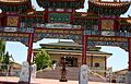
- Auburn Gallipoli Mosque: A beautiful mosque in Auburn.
- Northwest
Old_Government_House_010.jpg)
- Featherdale Wildlife Park: An Australian zoo in Doonside.
- Westfield Parramatta: A large shopping center in Parramatta.
- Old Government House: A historic house and tourist spot in Parramatta. It is Australia's oldest public building.
- Prospect Hill: A historically important ridge in the west.
- Lake Parramatta: A man-made lake for swimming and recreation.
- Balaka Falls: A natural waterfall in Carlingford.
- The Manse: A historic home in Mount Druitt, now a museum.
- Elizabeth Farm: A historic estate in Rosehill.
- Rosehill Gardens Racecourse: A famous horse racing track.
- Granville Town Hall: A historic building in Granville.
- Southwest

- Cecil Hills Farm: A heritage-listed home in Cecil Hills.
- Chipping Norton Lake: A popular recreation area for Liverpool and Fairfield.
- Georges River National Park: A beautiful national park.
- Macarthur Square: A large shopping center in Campbelltown.
- The Bland Oak: One of the oldest and largest trees in Sydney, in Carramar.
- Lansdowne Bridge: A heritage-listed road bridge over Prospect Creek.
- Oran Park (homestead): A historic homestead in Oran Park.
Images for kids
-
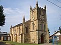
Presbyterian Church Wentworthville
-
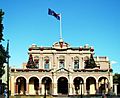
Parramatta Town Hall
-
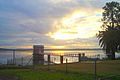
Prospect Reservoir
-
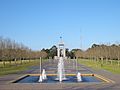
Bicentennial Park at Sydney Olympic Park
-
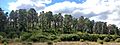
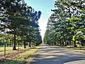
Prospect Hill Laccolith (Monterey Pine forest)
-
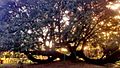
The Bland Oak tree
-
Entrance to Prospect Reservoir recreational area
-
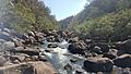
Rocky rapids of Bents Basin


