
Brevard County, Florida facts for kids
Quick facts for kids
Brevard County
|
|||||
|---|---|---|---|---|---|
.JPG)
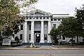
Historic Brevard County Courthouse in Titusville.
|
|||||
|
|||||

Location within the U.S. state of Florida
|
|||||
 Florida's location within the U.S. |
|||||
| Country | |||||
| State | |||||
| Founded | March 14, 1844 | ||||
| Named for | Theodorus W. Brevard | ||||
| Seat | Titusville | ||||
| Largest city | Palm Bay | ||||
| Area | |||||
| • Total | 1,557 sq mi (4,030 km2) | ||||
| • Land | 1,016 sq mi (2,630 km2) | ||||
| • Water | 541 sq mi (1,400 km2) 34.8% | ||||
| Population
(2020)
|
|||||
| • Total | 606,612 |
||||
| • Estimate
(2022)
|
630,692 | ||||
| • Density | 390/sq mi (150/km2) | ||||
| Time zone | UTC−5 (Eastern) | ||||
| • Summer (DST) | UTC−4 (EDT) | ||||
| Congressional district | 8th | ||||


Brevard County is a county in the U.S. state of Florida. It is located on the Atlantic coast in eastern Central Florida. In 2020, about 606,612 people lived here. This makes it the 10th most populated county in Florida.
The main office for the county government is in Titusville. However, a second important center for county work, including a courthouse, was built in 1989 in Viera, Florida. Viera is closer to the middle of the county.
Before European settlers arrived in the 1500s, Native American tribes lived in this area. The Windover Archeological Site in Brevard County shows that people lived here over 7,000 years ago. Brevard County was officially created in 1855. It is named after Theodore Washington Brevard, an early Florida settler and state official. The county's borders have changed many times over the years. The current borders have been in place since 1907.
Brevard County is also known as the Space Coast. This is because of the John F. Kennedy Space Center and the many space-related businesses here. Because of this, the area's telephone area code 321 was chosen to sound like a rocket "3, 2, 1 liftoff!" The county has many cities and towns, mostly along the Atlantic coast. The areas west of Interstate 95 are mostly rural or suburban. Brevard County is part of the Palm Bay–Melbourne–Titusville, FL Metropolitan Statistical Area.
Contents
- History of Brevard County
- Geography of Brevard County
- Population of Brevard County
- Elections in Brevard County
- Economy of Brevard County
- Former Place Names
- Education in Brevard County
- Libraries in Brevard County
- Sports in Brevard County
- Infrastructure in Brevard County
- Media in Brevard County
- Arts and Culture in Brevard County
- Images for kids
- See also
History of Brevard County
The first people, called Paleoindians, came to the Brevard County area about 12,000 to 10,000 years ago. They were semi-nomadic, meaning they moved around in small groups. Later, a new group called "the archaic people" arrived. These people were mainly fishermen.
The Windover Archeological Site, found in 1982, is very important. It has the largest collection of human remains and tools from the early Archaic Period (6,000–5,000 BCE). This site is now a National Historic Landmark. The Windover pond was used by these ancient Floridians as a burial ground. Bodies were wrapped in cloth and placed in the muddy soil. This pond was used for burials for about 1,000 years.
The Ais and Jaega tribes were the main groups living here when Ponce De Leon likely landed near Melbourne Beach in 1513. There were about 10,000 Native Americans in the area then. In 1570, Pedro Menéndez de Avilés wrote about the Ais people after his ship was wrecked near Cape Canaveral. In 1605, Alvero Mexia traveled from St. Augustine to the Indian River area. He helped create a friendly relationship with the Ais chiefs and drew a map of the area.
During the 1800s, Florida often changed county names and borders. St. Lucie County was created from Mosquito County in 1844. St. Lucie County was renamed Brevard County in 1855. It was named after Theodore Washington Brevard, who was a state official. This early "Brevard County" was very different from today's Brevard County. Its borders changed many times, shifting northward over the years. The original county seat was in Susannah, which is now Fort Pierce. Later, the southern part of Brevard split off to form a new St. Lucie County in 1905.
Big changes started when Henry Flagler's Florida East Coast Railroad came to the area. The railroad reached Titusville in 1886 and Melbourne in 1894. This brought more settlers and the first tourists. A large land boom happened in the 1920s after World War I. Many people moved to Florida, and land prices went up a lot. The Great Depression slowed this growth. Before World War II, the main jobs in Brevard were commercial fishing, growing citrus fruits, and tourism.
In the 1930s, Harry T. Moore became a civil rights leader, a teacher, and started the Brevard County NAACP. After the war, he became the head of the state NAACP. He helped many Black citizens register to vote. This was after a court ruled that only white people could vote in primary elections was illegal. He and his wife, Harriette, were fired from their teaching jobs because of their activism. On Christmas night in 1951, a bomb exploded under their home, and they both died. These murders were believed to be racially motivated. Several investigations were done, but no one was ever charged.
In 1940, the U.S. government built Naval Air Station Banana River (now Patrick Space Force Base). This was the first big government project in Brevard County. In the late 1950s, the government opened the Long Range Proving Ground, which later became the Kennedy Space Center. These facilities helped the county grow a lot. Brevard, which was once a quiet area, started attracting many educated workers and scientists. In the 1960s, new high bridges were built across the waterways to let boats pass underneath.
Because the county is long, people in the southern, more populated part felt too far from the county seat in Titusville. Titusville was about 50 miles (80 km) from Palm Bay, the largest city. Some residents even talked about creating a new county. So, the county decided to build a new administration complex in Viera in 1989. Viera is closer to the center of the county. Even though Titusville is still the official county seat, Viera is now where most county business happens.
Geography of Brevard County

Brevard County covers about 1,557 square miles (4,033 km²). About 1,016 square miles (2,631 km²) is land, and 541 square miles (1,401 km²) is water. This means about 34.8% of the county is water. Most of this water is the Atlantic Ocean, the St. Johns River, and the Indian River Lagoon. The county is larger than the country of Samoa.
Brevard County is located halfway between Jacksonville and Miami. It stretches about 72 miles (116 km) from north to south and is about 26.5 miles (42.6 km) wide on average. The St. Johns River starts in the marshes in the western part of the county.
The Atlantic Intracoastal Waterway runs along the eastern side of Brevard County. It includes the Indian River. Other important waterways are Lake Washington, Lake Poinsett, Lake Winder, Sawgrass Lake, and the Banana River.
Brevard County is the only county in the Palm Bay-Melbourne-Titusville, Florida Metropolitan Statistical Area (MSA). This means these three cities are the main cities in the area.
The county is often divided into three parts:
- North County: Includes Titusville, Mims, and Port St. John.
- Central Brevard: Includes Cocoa, Rockledge, Merritt Island, and Cocoa Beach.
- South County: Includes Melbourne, Palm Bay, Grant, Valkaria, and the South Beaches.
There are also many beaches along the coast. These include the North Reach, Patrick Space Force Base beach, Mid Reach, South Reach, and the South Beaches.
In 2012, there was a discussion about officially naming the long barrier island that runs along the coast. It was suggested to name it after the Ais people or Ponce de León Island. However, the island was not officially named.
Communities in Brevard County
Brevard County has 16 cities and towns. The largest city by population is Palm Bay, and the smallest is Melbourne Village.
Cities
Towns
Census-designated places
- Cocoa West
- June Park
- Merritt Island
- Micco
- Mims
- North Merritt Island
- Patrick SFB
- Port St. John
- Scottsmoor
- Sharpes
- South Patrick Shores
- Tropical Park
- Viera East
- Viera West
- West Canaveral Groves
Other unincorporated communities
Climate in Brevard County
Brevard County has a humid subtropical climate. This means it has hot, humid summers and mild winters. There are clear wet and dry seasons. The dry season is from December to May, and the wet season is from June to November. During the dry season, there can be droughts and a high risk of wildfires.
January is the coldest month, with average low temperatures around 50.7°F (10.4°C). July and August are the warmest months, with average high temperatures around 90°F (32°C). April is the driest month, and September is the wettest.
Florida is often affected by hurricanes. Brevard County is on the eastern coast. However, it is less often hit directly by hurricanes than other parts of Florida. This is because storms often curve away from the coast or weaken to tropical storms by the time they reach Brevard. No major hurricane (Category 3 or higher) has hit Brevard directly since 1850.
Even if a storm is not a full hurricane, the beach communities on the barrier island often have to evacuate. This is because of the danger of storm surge, which is when ocean water is pushed onto land.
Some hurricanes that have affected Brevard since 1950 include David (1979), Erin (1995), Charley (2004), Frances (2004), and Jeanne (2004). Tropical Storm Fay (2008) brought a record amount of rainfall.
Environment in Brevard County

Brevard County works with the government to protect nature. There are 250 square miles (647 km²) of protected wildlife refuges. These include the Merritt Island National Wildlife Refuge and the Canaveral National Seashore. These areas help protect wetlands and coastal regions. The ground in Brevard County is relatively young. This means it does not often have sinkholes, which are common in other parts of Florida.
Neighboring Counties
- Volusia County – north
- Indian River County – south
- Osceola County – southwest
- Orange County – west
Animals in Brevard County
There are about 4,000 different kinds of animals in Brevard County. Common mammals include North American river otters, bobcats, white-tailed deer, raccoons, and opossum. There are about 3,500 endangered gopher tortoises.
In 2015, there were 1,677 manatees in Brevard County. This was a big increase from 2014. However, many manatees still face dangers. Bottlenose dolphins are often seen in the Intracoastal Waterway. Other animals include alligators, sea turtles, and the rare North Atlantic right whale, which gives birth near the coast.
The brown recluse spider is not from this area, but it has adapted well here. The Florida Butterfly Monitoring Network has counted 45 different kinds of butterflies. Lovebug season happens twice a year, in May and August–September.
Birds in Brevard County
There are at least 163 different kinds of birds in the county. Turkey vultures migrate here and are protected by law. The most common winter bird is the lesser scaup, a diving duck. Other birds include the red-shouldered hawk, the endangered Florida scrub jay, and wood storks.
Plants in Brevard County
Native trees include the cabbage palm (Florida's state tree), fringetree, and geiger tree. Other native plants include sea grape, blackberry, and dandelion. On the east coast, mangroves usually grow from Cocoa Beach southward. North of there, they might compete with salt marshes.
Population of Brevard County
| Historical population | |||
|---|---|---|---|
| Census | Pop. | %± | |
| 1860 | 246 | — | |
| 1870 | 1,216 | 394.3% | |
| 1880 | 1,478 | 21.5% | |
| 1890 | 3,401 | 130.1% | |
| 1900 | 5,158 | 51.7% | |
| 1910 | 4,717 | −8.5% | |
| 1920 | 8,505 | 80.3% | |
| 1930 | 13,283 | 56.2% | |
| 1940 | 16,142 | 21.5% | |
| 1950 | 23,653 | 46.5% | |
| 1960 | 111,435 | 371.1% | |
| 1970 | 230,006 | 106.4% | |
| 1980 | 272,959 | 18.7% | |
| 1990 | 398,978 | 46.2% | |
| 2000 | 476,320 | 19.4% | |
| 2010 | 543,376 | 14.1% | |
| 2020 | 606,612 | 11.6% | |
| 2023 (est.) | 643,979 | 18.5% | |
| U.S. Decennial Census 1790–1960 1900–1990 1990–2000 2010–2015 2020–2022 |
|||
| Race | Pop 2010 | Pop 2020 | % 2010 | % 2020 |
|---|---|---|---|---|
| White (NH) | 421,466 | 430,936 | 77.56% | 71.04% |
| Black or African American (NH) | 52,677 | 56,498 | 9.69% | 9.31% |
| Native American or Alaska Native (NH) | 1,709 | 1,569 | 0.31% | 0.26% |
| Asian (NH) | 11,098 | 15,587 | 2.04% | 2.57% |
| Pacific Islander (NH) | 385 | 482 | 0.07% | 0.08% |
| Some Other Race (NH) | 1,075 | 3,389 | 0.2% | 0.56% |
| Mixed/Multi-Racial (NH) | 11,023 | 30,244 | 2.03% | 4.99% |
| Hispanic or Latino | 43,943 | 67,907 | 8.09% | 11.19% |
| Total | 543,376 | 606,612 |
In 2020, there were 606,612 people living in Brevard County. About 18.2% of residents were under 18 years old, and 24.2% were 65 or older. Most homes were owned by the people living in them.
In 2015, about 29% of all marriages in the county were between people of different races. This was one of the highest rates in the country.
In 2010, the average income for a household was $49,523. The average income for a family was $60,842. About 10.5% of the population lived below the poverty line. This included 14.4% of those under 18.
In 2010, about 8.6% of the people in the county were born in other countries. Most of these people had become U.S. citizens.
About 90% of residents in 2010 had a high school degree. About 25.7% had a college degree. Many residents (14.7%) over 25 had degrees in engineering. This is almost twice the national average.
Languages Spoken
In 2010, most residents (90.20%) spoke only English at home. About 5.29% spoke Spanish. Other languages spoken included German, French, and French Creole (like Haitian Creole).
Elections in Brevard County
The Republicans have the most registered voters in Brevard County.
| Brevard County voter registration & party enrollment as of January 31, 2024 | |||||
|---|---|---|---|---|---|
| Political party | Total voters | Percentage | |||
| Republican | 189,821 | 44.85% | |||
| Democratic | 113,961 | 26.93% | |||
| Independent | 106,735 | 25.22% | |||
| Third Parties | 12,711 | 3.00% | |||
| Total | 423,228 | 100% | |||
The county has voted for Republican candidates in every presidential election since 1980.
| Year | Republican | Democratic | Third party | |||
|---|---|---|---|---|---|---|
| No. | % | No. | % | No. | % | |
| 2024 | 216,533 | 59.65% | 141,233 | 38.91% | 5,249 | 1.45% |
| 2020 | 207,883 | 57.48% | 148,549 | 41.08% | 5,221 | 1.44% |
| 2016 | 181,848 | 57.16% | 119,679 | 37.62% | 16,614 | 5.22% |
| 2012 | 159,300 | 55.62% | 122,993 | 42.94% | 4,135 | 1.44% |
| 2008 | 157,589 | 54.54% | 127,620 | 44.17% | 3,718 | 1.29% |
| 2004 | 153,068 | 57.66% | 110,309 | 41.55% | 2,085 | 0.79% |
| 2000 | 115,253 | 52.75% | 97,341 | 44.55% | 5,894 | 2.70% |
| 1996 | 88,022 | 45.11% | 80,445 | 41.23% | 26,666 | 13.67% |
| 1992 | 84,585 | 43.19% | 61,091 | 31.19% | 50,184 | 25.62% |
| 1988 | 104,854 | 70.30% | 43,004 | 28.83% | 1,301 | 0.87% |
| 1984 | 102,477 | 73.45% | 36,985 | 26.51% | 49 | 0.04% |
| 1980 | 69,460 | 60.07% | 39,007 | 33.73% | 7,169 | 6.20% |
| 1976 | 44,470 | 48.15% | 46,421 | 50.26% | 1,473 | 1.59% |
| 1972 | 62,773 | 78.73% | 16,854 | 21.14% | 106 | 0.13% |
| 1968 | 37,124 | 48.02% | 18,281 | 23.65% | 21,909 | 28.34% |
| 1964 | 24,551 | 49.71% | 24,833 | 50.29% | 0 | 0.00% |
| 1960 | 17,585 | 61.37% | 11,069 | 38.63% | 0 | 0.00% |
| 1956 | 10,004 | 71.81% | 3,928 | 28.19% | 0 | 0.00% |
| 1952 | 6,756 | 61.91% | 4,157 | 38.09% | 0 | 0.00% |
| 1948 | 2,315 | 41.61% | 2,348 | 42.20% | 901 | 16.19% |
| 1944 | 1,769 | 40.02% | 2,651 | 59.98% | 0 | 0.00% |
| 1940 | 1,984 | 39.85% | 2,995 | 60.15% | 0 | 0.00% |
| 1936 | 1,147 | 33.28% | 2,300 | 66.72% | 0 | 0.00% |
| 1932 | 956 | 34.05% | 1,852 | 65.95% | 0 | 0.00% |
| 1928 | 1,830 | 62.12% | 1,063 | 36.08% | 53 | 1.80% |
| 1924 | 515 | 34.22% | 872 | 57.94% | 118 | 7.84% |
| 1920 | 659 | 39.30% | 894 | 53.31% | 124 | 7.39% |
| 1916 | 174 | 18.95% | 599 | 65.25% | 145 | 15.80% |
| 1912 | 61 | 10.34% | 357 | 60.51% | 172 | 29.15% |
| 1908 | 225 | 38.86% | 294 | 50.78% | 60 | 10.36% |
| 1904 | 125 | 17.58% | 553 | 77.78% | 33 | 4.64% |
| 1900 | 121 | 17.34% | 513 | 73.50% | 64 | 9.17% |
| 1896 | 337 | 37.36% | 505 | 55.99% | 60 | 6.65% |
| 1892 | 0 | 0.00% | 449 | 88.74% | 57 | 11.26% |
Economy of Brevard County
The total value of goods and services produced in the county was $30.1 billion in 2022. In the early 2010s, Brevard faced some economic challenges, including high unemployment and many home foreclosures. However, the area has since improved.
Even though there are not a huge number of high tech companies, Brevard was ranked as a top high-tech center in 2009. This is because it has many high-tech jobs compared to its total number of jobs.
During 2020, even with the COVID-19 pandemic, the Brevard area was one of the best-performing areas in the country.
Jobs and Income
In 2010, the average income for a person in the county was $27,606. Brevard County ranked 17th in Florida for income per person.
In 2012, about 79,621 people in the county received food stamps.
In 2009, many households received social security and pension payments.
In 2010, about 90% of residents had a high school degree. About 25.7% had a college degree. Many residents (14.7%) over 25 had degrees in engineering. This is almost twice the national average.
Housing in Brevard County
The value of property in the county grew a lot from 2002 to 2007. Then it dropped quickly. By 2017, it had risen again.
In 2011, Brevard County had one of the highest rates of foreclosures in the country. This meant many homes were worth less than their mortgages. However, the situation has improved since then.
In 2010, Kiplinger.com named Brevard County one of the five "best" places in America to retire. They looked at things like cost of living, weather, and crime rates.
Industries in Brevard County
The economy of Brevard is driven by several key areas:
- Trade, Transportation, and Utilities
- Professional and Business Services
- Government jobs
- Education and Health
- Manufacturing
- Leisure and hospitality
- Construction
- Financial services
Port Canaveral is one of the busiest cruise ports in the world. It has many cruise lines and handles a lot of cargo. The port adds about $500 million to the county's economy each year.
Two hospitals are among the largest private employers, with many thousands of workers.
The Kennedy Space Center (KSC) is a very important employer. In 2008, nearly 15,000 people worked there. KSC directly spent $1.82 billion in the county. Each space shuttle launch added $4 million to the county's economy. The Space Center Visitor's Complex also brings in a lot of money from tourists.
L3Harris Technologies, a large company, has the most private sector employees in the county.
In 2014, there were 495 aerospace companies in the county. They had over 36,000 workers and made $3.4 billion in sales.
The county has many restaurants and leisure businesses. In 2006, about 22,600 people worked in leisure and hospitality.
The Shiloh area is being considered as a place for a new commercial spaceport. This location is good because it is near the Kennedy Space Center and has open access to the Atlantic Ocean for launches.
Space Coast Credit Union is the largest local bank in Brevard County.
Military in Brevard County
Military bases in Brevard County include Patrick Space Force Base and Cape Canaveral Space Force Station (CCSFS). These bases employ many civilian federal workers and military personnel.
The United States Coast Guard (USCG) has a station at Port Canaveral. The Navy also has a special area at Port Canaveral for testing weapons on ballistic missile submarines.
Cape Canaveral Space Force Station is home to the Air Force Space & Missile Museum. It also has Launch Complex 26, where many early U.S. rockets were launched, including Explorer 1, America's first satellite.
Agriculture in Brevard County
About 23% of Brevard County's land is used for farming. This includes growing citrus fruits and raising cattle or horses. Large ranches like Deseret and Duda are here.
In 2009, aquaculture (farming seafood) was a $900,000 business. The county produces over 25% of all blue crabs on Florida's East Coast.
There are 40 4-H clubs in the county. These clubs help young people learn about agriculture and animals.
Tourism in Brevard County
In 2016, tourism made up about 9% of the county's total economy. It also employed about 13% of the workers. The county collects a special tax from tourists, which is used for beach improvements, visitor centers, and promoting the area.
In 2008, tourists spent $2.89 billion in the county. This money came from lodging, food, shopping, and visits to places like the Kennedy Space Center and Port Canaveral. Most tourists come from Florida, Ohio, Illinois, and Michigan. International visitors mainly come from Canada, the United Kingdom, and Germany.
About 1.6 million people visited the Space Center Visitor Complex in 2008.
The Space Coast Office of Tourism and the Brevard County Tourist Development Council work to attract visitors. They use tourist tax money for things like beach improvements, the Brevard Zoo, and the Space Coast Stadium.
Many art festivals are held each year, attracting thousands of people. Other annual festivals are held in parks throughout the year. The Brevard Cultural Alliance (BCA) provides information on local events and interesting sites.
The annual Florida Key Lime Pie Festival is held every January. In 2018, The Florida Key Lime Pie Company made the World's largest key lime pie.
The annual Grant Seafood Festival attracts up to 50,000 people. It is the largest and longest-running seafood festival in the Southeast.
Former Place Names
Some places in Brevard County have changed names over time. Some were early settlements, and others were old train stations. A few disappeared when the Kennedy Space Center was built.
Education in Brevard County
For higher education, students can attend Eastern Florida State College (EFSC) and Florida Institute of Technology. There are also smaller campuses for other universities like the University of Central Florida.
For younger students, education is provided by the Brevard Public Schools and private schools. In 2011, six public schools in Brevard were ranked among the top ten schools in Florida.
Libraries in Brevard County
The Brevard County Library System has 17 branches. The Merritt Island Public Library is part of a separate library district, but it is still counted as part of the county system.
Sports in Brevard County
- Minor League Baseball
Brevard County was home to the Brevard County Manatees, a minor league baseball team, until 2016.
- Major League Baseball
The Washington Nationals baseball team used to hold their spring training at Space Coast Stadium in Viera until 2016. They played about 14 games there each March.
- Amateur Sports
Besides school sports, there are youth leagues for many sports. These include basketball, football, soccer, baseball, and swimming.
Infrastructure in Brevard County
Transportation
Brevard County has many ways to get around, including highways, shipping, and airports. What makes it special is its role in space transportation.
Public transportation is provided by Space Coast Area Transit.
Airports
- Arthur Dunn Airpark
- Melbourne Orlando International Airport
- Merritt Island Airport
- Space Coast Regional Airport
- Valkaria Airport
Power
Florida Power & Light (FPL) has a power plant in Sharpes. It provides most of the electricity for the county. In 2008, FPL announced plans to build a new, more efficient natural gas plant.
Florida City Gas provides natural gas to parts of the county.
Communication
The area code for most of the county is "321". This number was chosen to sound like the "3...2...1... lift-off!" countdown for rockets. A small part of the southern county uses the 772 area code.
Waste Management
The county government manages landfills for solid waste. The Brevard County Central Disposal Facility in Cocoa is a large site that receives a lot of waste each year. The county also plans to build a new landfill.
The county contracts with companies to pick up trash for many homes.
Water
In 2013, the county used about 100 million gallons (378 million liters) of water every day. About half of this was used for watering landscapes.
Several cities and the county itself sell water to residents.
Wastewater
The county has six Wastewater Treatment Facilities. Some cities also have their own wastewater treatment plants.
Media in Brevard County
Brevard County is part of the Orlando-Daytona Beach-Melbourne-Cocoa-Clermont television market. This means it receives many TV and radio stations from Orlando.
Newspapers
Florida Today is the main daily newspaper for Brevard County and the Space Coast. El Playero is a monthly newspaper for Spanish speakers. Other local news sources include Brevard Business News, Hometown News, and Space Coast Daily.
Radio
Television
Most homes in Brevard County get cable television from Charter Spectrum. Comcast serves the Micco and Palm Bay areas.
Local TV stations in Brevard County include:
Films and Television Shows
Several films and TV shows have been filmed or set in Brevard County:
- Matinee (1993) was filmed in Cocoa Village.
- Movies like Apollo 13 (1995) and Transformers: Dark of the Moon (2010) used facilities at Cape Canaveral or Kennedy Space Center.
- Marvin's Room (1996) was filmed in Rockledge.
- The 1960s TV show I Dream of Jeannie was set in Cocoa Beach and Cape Canaveral.
Arts and Culture in Brevard County
The Maxwell C. King Center for the Performing Arts is a large theater that hosts local shows, Broadway productions, ballet, and symphony performances.
The Brevard Symphony Orchestra and Space Coast Ballet offer professional shows. There are also community orchestras and choral groups.
The Brevard Zoo is a 75-acre (30-hectare) zoo with over 650 animals from around the world. Visitors can feed giraffes and lorikeets, take kayak tours, and ride a train.
- Ballet
The Space Coast Ballet puts on professional shows, including The Nutcracker every year. They feature both professional dancers and local students.
- Museums and Attractions
The Space Coast has many museums. These include rocket exhibits at the Kennedy Space Center Visitor Complex and the Air Force Space and Missile Museum. There are also local history museums.
The Kennedy Space Center Visitor Complex teaches visitors about America's space program. You can see the Space Shuttle launch pads, the Vehicle Assembly Building, and a huge rocket.
The US Space Walk of Fame in Titusville honors astronauts and the people who helped with space exploration. It has a museum and monuments.
The Brevard Museum of History & Natural Science displays the remains of "Windover Man," the oldest human remains found in North America. It also shows how Native Americans and early Florida pioneers lived.
The Liberty Bell Memorial Museum has a copy of the Liberty Bell and historical items. It also honors military veterans.
The Harry T. and Harriette V. Moore Memorial Park and Cultural Center has a museum about the civil rights movement and the story of Harry T. and Harriette V. Moore.
The Wizard of Oz Museum has a large collection of over 3,000 items related to the Wizard of Oz. This includes early copies of the book and movie scripts. It also has an immersive experience with projectors.
Images for kids
-
Historic Brevard County Courthouse in Titusville.
-
Flag of Brevard County, Florida
-
Seal of Brevard County, Florida
-

Logo of Brevard County, Florida
-
The Brevard–Volusia county line
-
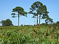
Pine flatwoods and sand pine scrub
See also
 In Spanish: Condado de Brevard para niños
