
Providence, Rhode Island facts for kids
Quick facts for kids
Providence
|
|||
|---|---|---|---|
|
|
|||
|
|||
| Nickname(s):
The Creative Capital, the Renaissance City, the Divine City, PVD, Prov
|
|||
| Motto(s):
"What Cheer?"
|
|||

Providence
Location in the United States
|
|||
| Country | United States | ||
| State | Rhode Island | ||
| County | Providence | ||
| Region | New England | ||
| Settled | 1636 | ||
| Incorporated (city) | November 5, 1832 | ||
| Founded by | Roger Williams | ||
| Named for | Divine providence | ||
| Government | |||
| • Type | Mayor–council | ||
| • Body | Providence City Council | ||
| Area | |||
| • State capital city | 20.58 sq mi (53.31 km2) | ||
| • Land | 18.41 sq mi (47.67 km2) | ||
| • Water | 2.18 sq mi (5.64 km2) | ||
| Elevation | 10 ft (3 m) | ||
| Population
(2020)
|
|||
| • State capital city | 190,934 | ||
| • Rank | US: 134th | ||
| • Density | 10,373.47/sq mi (4,005.25/km2) | ||
| • Urban | 1,285,806 (US: 39th) | ||
| • Urban density | 2,362.5/sq mi (912.2/km2) | ||
| • Metro | 1,676,579 (US: 38th) | ||
| Demonym(s) | Providentian | ||
| GDP | |||
| • Metro | $105.561 billion (2022) | ||
| Time zone | UTC−5 (Eastern Time Zone) | ||
| • Summer (DST) | UTC−4 (EDT) | ||
| ZIP Codes |
02901–02912, 02918-02919, 02940
|
||
| Area code | 401 | ||
| FIPS code | 44-59000 | ||


.jpg)


Providence is the capital city of Rhode Island. It is also the most populated city in the state. Providence is one of the oldest cities in New England. It was started in 1636 by Roger Williams, a religious leader. He named the area "Providence" because he believed God had kindly led him and his followers there.
The city grew into a busy port. It is located where the Providence River meets Narragansett Bay. Providence was one of the first cities in the United States to become industrial. It was known for making textiles (like cloth), tools, jewelry, and silverware.
Today, Providence has eight hospitals and many colleges. This has changed the city's economy to focus more on service industries. However, some manufacturing still happens. In 2020, Providence had a population of 190,934 people. It is the third-largest city in New England, after Boston and Worcester, Massachusetts. The larger Providence metropolitan area has over 1.6 million residents.
Contents
History of Providence
Providence was settled in June 1636 by Roger Williams. He was a religious leader who had been asked to leave the Massachusetts Bay Colony. Williams believed that the church and state should be separate. He also thought it was wrong for colonists to take land from Native Americans.
Williams and his group first settled in Rumford, Rhode Island. They later moved along the Seekonk River and Providence River. They settled where the Moshassuck and Woonasquatucket Rivers meet. He named the settlement "Providence" to thank God.
Unlike some other colonies, Providence did not have a royal charter. The settlers organized themselves. In 1638, they divided land on the eastern side of the Providence River. Over the next 20 years, Providence grew. It became a place where people farmed and fished.
In 1652, Providence tried to limit how long people could be forced to work. This was the first anti-slavery law in the U.S., but it wasn't always followed. Later, in 1703, slavery was made legal again in Rhode Island. Providence became a major port, and some merchants were involved in the slave trade.
In March 1676, much of Providence was burned during King Philip's War. This was a conflict with the Narragansetts. In 1770, Brown University moved to Providence. It was known as Rhode Island College then. This move showed that Providence was becoming more important than Newport.
In 1772, a group from Providence burned a British ship. This event was called the Gaspee Affair. It was the first armed resistance against British rule in America. It happened before the more famous Boston Tea Party. Rhode Island was the first colony to declare its freedom from Britain on May 4, 1776. It was also the last state to approve the United States Constitution. This happened on May 29, 1790, after it was promised that a Bill of Rights would be added.
After the war, Providence was the ninth-largest city in the country. Its economy changed from shipping to manufacturing. The city made machinery, tools, silverware, jewelry, and textiles. By the early 1900s, Providence had some of the biggest factories in the U.S. Many immigrants came to the city for jobs. They came from Ireland, Germany, Italy, and other countries.
Providence became an official city in 1831. The city government was in the Market House until 1878. Then, the city offices moved to the Providence City Hall.
During the American Civil War, people in Providence had mixed feelings about slavery. However, many people volunteered for the army. The city's factories were very important for the Union side. After the war, Providence grew a lot. Its population increased from 54,595 in 1865 to 175,597 by 1900.
By the early 1900s, Providence was a very rich city. It was a major center for making industrial products. Companies like Brown & Sharpe and Gorham Manufacturing were based there. Making jewelry also became a very important local industry. In the 1960s, Providence was called "the jewelry capital of the world."
The city faced challenges in the mid-1920s as factories started to close. The Great Depression caused many people to lose their jobs. In 1938, the New England Hurricane of 1938 flooded downtown. Many textile mills never reopened after the storm. Providence's population dropped from its highest point in 1940. Many middle-class families moved to the suburbs.
From 1975 to 1982, a lot of money was invested to improve the city. In the 1990s, Providence worked hard to rebuild. Major projects included moving railroad tracks and rivers. They also created Waterplace Park and a riverwalk. The Providence Place Mall was also built. The city's population started to grow again in 1980.
In the early 2000s, Providence focused on a new economic plan. It aimed to become a "knowledge-based economy." This meant focusing on science and technology. The old Jewelry District was even renamed the "Knowledge District." Despite new investments, about 21.5% of the city's population lives below the poverty line. Housing prices have also increased, making it harder for some people to afford homes.
Geography of Providence
Providence is a small city. It covers about 20.5 square miles (53.3 square kilometers). About 18.5 square miles (47.9 square kilometers) is land, and 2.1 square miles (5.4 square kilometers) is water. The city is located at the top of Narragansett Bay. The Providence River flows through the city center into the bay. This river is formed by the Moshassuck and Woonasquatucket Rivers joining together.
Waterplace Park and its riverwalks are along the riverbanks in Downtown. Providence is said to be built on seven hills, like the city of Rome.
Providence Neighborhoods
Providence has 25 official neighborhoods. These are often grouped into larger areas:
- The East Side includes Blackstone, Hope, Mount Hope, College Hill, Wayland, and Fox Point.
- The Jewelry District is an area near the highways and the Providence River. The city is trying to rename it the Knowledge District. This is because new science and technology businesses are moving there.
- The North End is made up of Charles, Wanskuck, Smith Hill, Elmhurst, and Mount Pleasant.
- The South Side (or South Providence) includes Elmwood, Lower South Providence, Upper South Providence, Washington Park, and the West End.
- West Broadway is its own neighborhood. It is part of Federal Hill and the northern West End.
Cityscape and Architecture
Providence is a compact city, meaning it's not very spread out. This is common for older cities on the eastern seaboard. The streets are not in a perfect grid. They connect and spread out from busy places like Market Square.
Downtown Providence has many old buildings from the 1800s. These include Federal and Victorian styles. There are also newer postmodern and modernist buildings. The newer area, called "Capitol Center," was built on land that used to be railroad tracks. This part of Downtown has open spaces and wide roads.
Many of Rhode Island's tallest buildings are in Downtown Providence. The tallest is the Industrial National Bank Building, which is 426 feet (130 m) tall. Other important buildings include One Financial Plaza and the Textron Tower. Downtown is also home to the historic Providence Biltmore hotel and the Westminster Arcade. The Westminster Arcade is the oldest enclosed shopping mall in the U.S.
The southern waterfront area has oil tanks, ferry docks, and power plants. The Fox Point Hurricane Barrier is also here. It was built to protect Providence from large storm surges, like those during the 1938 Hurricane and 1954 Hurricane Carol.
Climate and Weather
Providence has a climate with hot summers and cool to cold winters. The Atlantic Ocean helps keep Rhode Island warmer than inland areas of New England.
July is the warmest month, with an average temperature of about 73.5°F (23.1°C). Temperatures can reach 90°F (32°C) or higher about 10 days each summer. January is the coldest month, with an average of 29.2°F (-1.6°C). Temperatures can drop to 10°F (-12°C) or lower about 11 days each winter.
The lowest temperature ever recorded was -17°F (-27°C) in 1934. The highest was 104°F (40°C) in 1975. Temperatures of 0°F (-18°C) or lower are rare. Temperatures of 100°F (38°C) or higher are even rarer.
Providence gets about 3 to 4.5 inches (76 to 114 mm) of rain each month. Summers usually have a bit less rain than winters. In winter, nor'easter storms can bring a lot of rain and snow. Hurricanes have also hit Providence. The city's location at the top of Narragansett Bay makes it open to storm surges. Hurricane Carol in 1954 and the 1938 Hurricane caused a lot of damage.
| Climate data for Providence, Rhode Island (T. F. Green Airport), 1981–2010 normals, extremes 1904–present | |||||||||||||
|---|---|---|---|---|---|---|---|---|---|---|---|---|---|
| Month | Jan | Feb | Mar | Apr | May | Jun | Jul | Aug | Sep | Oct | Nov | Dec | Year |
| Record high °F (°C) | 69 (21) |
72 (22) |
90 (32) |
98 (37) |
96 (36) |
98 (37) |
102 (39) |
104 (40) |
100 (38) |
88 (31) |
81 (27) |
77 (25) |
104 (40) |
| Mean maximum °F (°C) | 57.2 (14.0) |
58.3 (14.6) |
68.4 (20.2) |
80.3 (26.8) |
86.2 (30.1) |
91.3 (32.9) |
94.5 (34.7) |
92.3 (33.5) |
87.0 (30.6) |
78.1 (25.6) |
70.0 (21.1) |
60.8 (16.0) |
96.2 (35.7) |
| Mean daily maximum °F (°C) | 37.4 (3.0) |
40.3 (4.6) |
47.8 (8.8) |
58.6 (14.8) |
68.4 (20.2) |
77.5 (25.3) |
82.8 (28.2) |
81.4 (27.4) |
74.2 (23.4) |
63.3 (17.4) |
53.2 (11.8) |
42.3 (5.7) |
60.6 (15.9) |
| Mean daily minimum °F (°C) | 21.0 (−6.1) |
23.6 (−4.7) |
30.0 (−1.1) |
39.6 (4.2) |
48.6 (9.2) |
58.4 (14.7) |
64.2 (17.9) |
63.2 (17.3) |
55.3 (12.9) |
43.9 (6.6) |
35.7 (2.1) |
26.3 (−3.2) |
42.5 (5.8) |
| Mean minimum °F (°C) | 2.9 (−16.2) |
7.7 (−13.5) |
14.7 (−9.6) |
28.8 (−1.8) |
36.9 (2.7) |
47.1 (8.4) |
55.0 (12.8) |
52.4 (11.3) |
42.2 (5.7) |
31.2 (−0.4) |
21.7 (−5.7) |
10.4 (−12.0) |
0.9 (−17.3) |
| Record low °F (°C) | −13 (−25) |
−17 (−27) |
1 (−17) |
11 (−12) |
29 (−2) |
39 (4) |
48 (9) |
40 (4) |
32 (0) |
20 (−7) |
6 (−14) |
−12 (−24) |
−17 (−27) |
| Average precipitation inches (mm) | 3.86 (98) |
3.29 (84) |
5.01 (127) |
4.36 (111) |
3.55 (90) |
3.64 (92) |
3.29 (84) |
3.60 (91) |
3.92 (100) |
3.93 (100) |
4.51 (115) |
4.22 (107) |
47.18 (1,198) |
| Average snowfall inches (cm) | 9.0 (23) |
8.5 (22) |
5.5 (14) |
0.6 (1.5) |
0 (0) |
0 (0) |
0 (0) |
0 (0) |
0 (0) |
0 (0) |
1.5 (3.8) |
8.7 (22) |
33.8 (86) |
| Average precipitation days (≥ 0.01 in) | 10.9 | 9.7 | 11.9 | 11.3 | 12.0 | 10.9 | 9.4 | 9.0 | 8.7 | 9.4 | 10.1 | 11.6 | 124.9 |
| Average snowy days (≥ 0.1 in) | 5.7 | 4.6 | 3.5 | 0.4 | 0 | 0 | 0 | 0 | 0 | 0 | 0.6 | 3.9 | 18.7 |
| Average relative humidity (%) | 63.9 | 63.0 | 62.9 | 61.4 | 66.6 | 70.1 | 71.0 | 72.5 | 73.0 | 70.2 | 68.9 | 67.0 | 67.5 |
| Mean monthly sunshine hours | 171.7 | 172.6 | 215.6 | 225.1 | 254.9 | 274.1 | 290.6 | 262.8 | 233.0 | 208.7 | 148.0 | 148.6 | 2,605.7 |
| Percent possible sunshine | 58 | 58 | 58 | 56 | 57 | 60 | 63 | 61 | 62 | 61 | 50 | 52 | 58 |
| Source: NOAA (relative humidity and sun 1961–1990), The Weather Channel | |||||||||||||
People and Diversity
| Historical population | ||
|---|---|---|
| Year | Pop. | ±% |
| 1708 | 1,446 | — |
| 1730 | 3,916 | +170.8% |
| 1748 | 3,452 | −11.8% |
| 1755 | 3,159 | −8.5% |
| 1774 | 4,321 | +36.8% |
| 1782 | 4,310 | −0.3% |
| 1790 | 6,380 | +48.0% |
| 1800 | 7,614 | +19.3% |
| 1810 | 10,070 | +32.3% |
| 1820 | 11,767 | +16.9% |
| 1830 | 16,833 | +43.1% |
| 1840 | 23,171 | +37.7% |
| 1850 | 41,513 | +79.2% |
| 1860 | 50,666 | +22.0% |
| 1870 | 68,904 | +36.0% |
| 1880 | 104,857 | +52.2% |
| 1890 | 132,146 | +26.0% |
| 1900 | 175,597 | +32.9% |
| 1910 | 224,326 | +27.8% |
| 1920 | 237,595 | +5.9% |
| 1930 | 252,981 | +6.5% |
| 1940 | 253,504 | +0.2% |
| 1950 | 248,674 | −1.9% |
| 1960 | 207,498 | −16.6% |
| 1970 | 179,213 | −13.6% |
| 1980 | 156,804 | −12.5% |
| 1990 | 160,728 | +2.5% |
| 2000 | 173,618 | +8.0% |
| 2010 | 178,042 | +2.5% |
| 2020 | 190,934 | +7.2% |
| 2022 | 189,563 | −0.7% |
| Source: Largest Cities and Other Urban Places in the United States 1790 to 1990 2022 Estimate 1708 to 1782 |
||
Providence has a very diverse population. In 2020, about 53.1% of the people were white Americans. This includes a large number of white people of Hispanic origin. About 33.8% of the population were non-Hispanic white. Providence has had many Italian Americans since the early 1900s. About 14% of the people say they have Italian ancestors. The 'Little Italy' area in Federal Hill shows this influence. Many Irish immigrants have also shaped the city's history.
In 2020, people of Hispanic or Latino origin made up 43.5% of the city's population. Most Hispanic people in Providence are from the Dominican Republic. This community is one of the largest in the United States. Other large Hispanic groups include Puerto Ricans, Guatemalans, and Colombians. These groups live in many parts of Providence, especially in the Elmwood and West End neighborhoods.
African Americans make up 16.1% of the city's population. They are mostly found in the Mount Hope and South Providence neighborhoods. Providence also has smaller communities from Liberia and Haiti. Asian-Americans are 5.6% of the population. The largest Asian groups are Cambodians, Chinese, and Indians.
Providence has a large community of immigrants from countries where Portuguese is spoken. These include Portugal, Brazil, and Cape Verde. These residents live mostly in the Washington Park and Fox Point neighborhoods. Cape Verdeans make up 2% of the city's population.
The average income per person in 2000 was $15,525. This is lower than the state and national averages. The city has a high rate of poverty. About 29.1% of the population and 23.9% of families live below the poverty line. Poverty affects children even more, with 40.1% of those under 18 living in poverty. These areas are mostly west of Downtown, in neighborhoods like Olneyville.
Providence Economy
More than one-third of Providence's economy comes from trade, transportation, utilities, and education and health services. As the capital of Rhode Island, government services also provide many jobs. The unemployment rate in the city was 5.0% in August 2022.
Many important companies have their main offices in Providence. These include Textron, which is a large industrial company, and United Natural Foods, which distributes natural and organic foods. Other companies include Citizens Bank and Providence Equity. Providence is also home to some of toy maker Hasbro's operations.
The city has the Rhode Island Convention Center, which opened in 1993. It is connected to the Providence Place Mall, a large shopping center.
Arts and Culture in Providence
Providence's culture is very similar to the overall culture of Rhode Island. The city has a unique accent. Providence also loves coffee and doughnuts. It has the most coffee and doughnut shops per person of any city in the country. Providence is also known for having many restaurants per person.
In the summer, the city often hosts WaterFire. This is an art event where about 100 bonfires burn on the three rivers downtown. Classical and world music plays during these events.
Providence has several neighborhoods with strong ethnic cultures. These include Federal Hill (Italian) and Fox Point (Portuguese). There are also many community groups and arts organizations in the city.
Providence is home to the Tony Award-winning theater group Trinity Repertory Company. It also has the Rhode Island Philharmonic Orchestra. The city has several places for performing arts, like the Providence Performing Arts Center. Providence is known for its underground music scene. AS220 is a non-profit arts center with spaces for art, education, and performances.
PVDFest is a yearly outdoor arts festival. It features live music, art, craft markets, and food from around the world.
Places to Visit in Providence
Providence has a large park system, covering 1,200 acres (4.9 square kilometers). Important parks include Waterplace Park and the Riverwalk, Roger Williams Park, and Prospect Terrace Park. Prospect Terrace Park offers great views of downtown. It also has a 15-foot (4.6 m) statue of Roger Williams looking over the city. Since Providence is one of America's first cities, it has many historic buildings. The East Side neighborhood has the largest area of historic buildings listed on the National Register of Historic Places in the U.S. Many houses there were built before the American Revolution.
Providence's East Side is home to the First Baptist Church in America. Roger Williams founded this church in 1638. The Old State House was the state's capitol from 1762 to 1904. The dome of the State House is the fourth-largest self-supporting marble dome in the world. The Westminster Arcade is the oldest enclosed shopping center in the U.S.
The Rhode Island School of Design Museum has one of the largest art collections in the United States. The Providence Athenæum is the fourth oldest library in the U.S. Famous writers like Edgar Allan Poe and H. P. Lovecraft used to visit this library.
The Bank Newport City Center is downtown, near Kennedy Plaza. It is connected to Waterplace Park by a tunnel. Another downtown landmark is the Providence Biltmore, a historic hotel.
In the southern part of the city, you can find the Big Blue Bug. This is a huge termite statue and the mascot for a pest control company. Roger Williams Park has a zoo, a botanical center, and a Museum of Natural History and Planetarium.
Sports in Providence
Providence is home to the Providence Bruins hockey team. They play in the American Hockey League at the Amica Mutual Pavilion. From 1926 to 1972, the Providence Reds (another hockey team) played in the city.
The National Football League's New England Patriots and Major League Soccer's New England Revolution play in Foxborough, Massachusetts. This town is between Providence and Boston. Providence used to have two major league teams: the NFL's Providence Steam Roller and the National Basketball Association's Providence Steamrollers. The Rhode Island Auditorium also hosted 29 boxing matches for Rocky Marciano.
The city's old baseball team, the Providence Grays, played in the National League from 1879 to 1885. They won baseball's first "world championship series" in 1884. In 1914, Babe Ruth played for a minor league team in Providence, also called the Grays, before joining the major leagues. Most baseball fans in Providence follow the Boston Red Sox.
Brown University and Providence College have NCAA Division I sports teams. Providence College is part of the Big East Conference.
Providence has also hosted extreme sports events. It hosted the Gravity Games from 1999 to 2001. It was also the first city to host ESPN's X Games in 1995. Providence has its own roller derby league, started in 2004.
The Providence Hurling Club was founded in 2015. They play in the Junior C division of the Boston GAA. They won titles in 2021 and 2023.
Education in Providence
Schools for Kids and Teens
The Providence Public School District serves about 21,700 students from pre-Kindergarten to grade 12. The district has 21 elementary schools, seven middle schools, and nine high schools. Some of these are magnet schools, like Nathanael Greene and Classical. The public high school graduation rate in 2019 was 74%.
Many private schools also serve students in Providence. Community Preparatory School is a private school for younger students. In the city's East Side, there are private schools like Moses Brown and the Lincoln School. La Salle Academy, a Catholic high school, is in the North End.
Colleges and Universities
The main campuses of five colleges and universities are in Providence:
- Brown University: An Ivy League university and one of the oldest colleges in the nation.
- Johnson & Wales University
- Providence College
- Rhode Island College: The state's oldest public college.
- Rhode Island School of Design (RISD)
Also, the Community College of Rhode Island, Roger Williams University, and University of Rhode Island have smaller campuses in the city. Between these schools, there are about 32,000 to 44,000 college students. Higher education plays a big role in the city's economy. Brown University is the city's second-largest employer.
Media in Providence
Providence is the center for TV and radio in Southern New England. This area also includes cities like Fall River and New Bedford. The city has TV stations for all major American television networks. It also has many local radio stations.
City Services and Transportation
Getting Around Providence
Providence is served by T. F. Green Airport in Warwick. Providence Station is located downtown. It is served by Amtrak trains and MBTA Commuter Rail services. About 2,400 passengers use the station each day.
I-95 runs through Providence from north to south. I-195 connects the city to eastern Rhode Island and southeastern Massachusetts. The city started a project called Iway in 2007. This project moved I-195 to make the area safer and connect parts of the city that were separated by the highway.
The Port of Providence (ProvPort) is the second-largest deep-water seaport in New England. It handles goods like cement, chemicals, and petroleum.
Kennedy Plaza in Downtown Providence is a major hub for public transportation. Local buses are managed by Rhode Island Public Transit Authority (RIPTA). More than 71,000 people use Kennedy Plaza each day. RIPTA also has a "Rapid Bus" service, the R-Line. This connects the suburbs to Downtown Providence. There is also the East Side Trolley Tunnel for RIPTA buses.
The city has several traffic-free bicycle paths. These include the East Bay Bike Path and the Blackstone River Greenway. There are also bike lanes on some city streets.
In 2017, Providence started a bike sharing program. However, it faced problems and was stopped in 2019. A new company, Spin, brought back a bike sharing program in 2021.
In August 2019, a pedestrian bridge opened. It connects the east and west sides of Providence over the Providence River. In 2020, Mayor Jorge Elorza announced a "Great Streets" plan. This plan aims to improve public spaces for walking, biking, and public transit. It includes creating an "Urban Trail Network" with 60 miles (97 km) of bike paths and greenways.
City Utilities
Electricity and natural gas are provided by Rhode Island Energy. Providence Water manages the city's drinking water. Most of the water comes from the Scituate Reservoir. The city is working to replace old lead pipes to improve water safety.
Police and Fire Services
The city's fire and police departments are in a large Public Safety Complex. This building was opened in 2002. The Providence Police Department had a budget of $85.6 million in 2020 and employed 453 officers.
Sister Cities
Providence has four sister cities:
 Praia, Cape Verde (1994)
 Santo Domingo, Dominican Republic (2004)
 Zhuhai, China (2015)
 Guatemala City, Guatemala (2016)
Friendship Cities
 Stepanakert, Artsakh (2023)
Images for kids
-
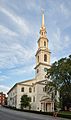
The First Baptist Church in America is the oldest Baptist church in America. It was founded by Roger Williams in 1638. Its current building was first used in 1775.
-
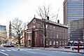
Market Square was the center of city life in the 1800s. Market House was where the city council met before Providence City Hall was built.
-
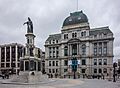
Providence City Hall was built in 1878.
-
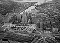
An aerial photo of Downtown Providence taken in 1951.
-
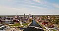
The Providence skyline seen from above the Providence River.
-
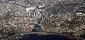
Downtown Providence and the East Side in 2010.
-
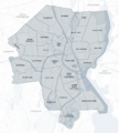
Map of neighborhoods in Providence.
-
The Shepard Company Building in Downtown Providence.
-
Burnside Park in Downtown Providence, facing the city's tall buildings.
-
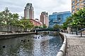
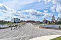
The Providence Riverwalk, at the edge of downtown.
-
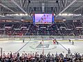
The Amica Mutual Pavilion hosted the NCAA ice hockey East Regionals in 2019.
-
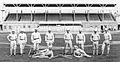
The 1879 National League champion Providence Grays baseball team.
-
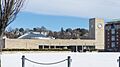
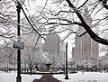
Providence Station in winter.
-
The Michael S. Van Leesten Memorial Bridge opened in August 2019.
-
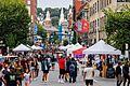
Washington St. in downtown Providence during PVDFest 2024.
-
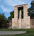
Prospect Terrace Park.
-
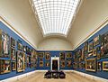
Rhode Island School of Design Museum.
-
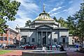
Old Stone Bank.
-
RISD.
-
Johnson & Wales.
-
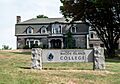
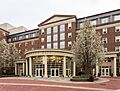
Rhode Island College.
-
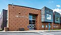
Community College of RI.


_2012.jpg)


See also
 In Spanish: Providence (Rhode Island) para niños
