Geography of Michigan facts for kids
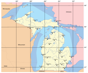
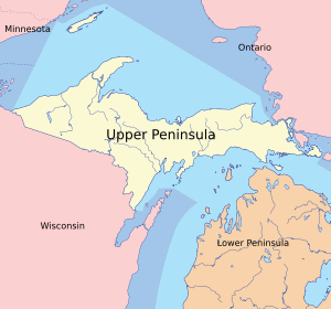
Michigan is a really cool state in the United States, known for its unique shape and being surrounded by four of the five Great Lakes. It's made up of two main parts: the Upper Peninsula (often called the U.P.) and the Lower Peninsula. These two parts are separated by the Straits of Mackinac, a narrow waterway.
The Upper Peninsula shares a border with Wisconsin to the southwest. The Lower Peninsula borders Indiana and Ohio to the south. Both parts of Michigan are also separated from the Canadian province of Ontario by the Great Lakes. Because so much of Michigan is surrounded by these huge lakes, almost all of its rivers and streams flow into the Great Lakes and eventually into the Saint Lawrence River.
Michigan has a lot of water! Its territory includes about half of Lake Superior, Lake Michigan, and Lake Huron. It also has smaller parts of Lake St. Clair and Lake Erie. Inside the state, there are an amazing 11,000 inland lakes. Michigan is a big state, covering about 58,110 square miles (150,500 km2) of land. When you add its Great Lakes waters and inland waters, its total area is about 97,990 square miles (253,800 km2). This makes it the largest state east of the Mississippi River and the eleventh largest state overall. More than half of Michigan's land, about 30,156 square miles (78,100 km2), is covered in forests.
Contents
Exploring the Upper Peninsula
The Upper Peninsula is a wild and beautiful place. It's very heavily forested and has mountains in the west. The Porcupine Mountains are part of one of the oldest mountain chains in the world. They rise almost 2,000 feet (610 m) above sea level. These mountains create a natural divide, sending streams either into Lake Superior or Lake Michigan.
The highest point in Michigan is Mount Arvon, located in the Huron Mountains in the Upper Peninsula. It stands at 1,979 feet (603 m) tall. Even though the U.P. is as big as four smaller states combined (Connecticut, Delaware, Massachusetts, and Rhode Island), it has fewer than 330,000 people living there. This makes it feel very remote and natural.
The Upper Peninsula is quite far from the main population centers of Michigan. For example, Ironwood in the far west of the U.P. is 630 miles (1,015 km) from Lambertville in the Lower Peninsula. This distance makes the U.P. feel culturally and economically different from the rest of the state.
Discovering the Lower Peninsula
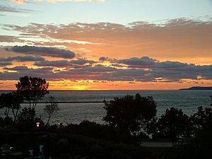
The Lower Peninsula is shaped like a mitten, which is why Michigan is often called the "Mitten State." It's about 277 miles (446 km) long from north to south and 195 miles (314 km) wide from east to west. This part of the state makes up more than two-thirds of Michigan's land area.
The land in the Lower Peninsula is mostly flat. However, you'll find some small, rounded hills and ridges left behind by glaciers. These are usually only a few hundred feet tall. The highest point in the Lower Peninsula is Briar Hill, at 1,705 feet (520 m), or other nearby spots around Cadillac. The lowest point is the surface of Lake Erie, which is 571 feet (174 m) above sea level.
One famous part of the Lower Peninsula's shape is "the Thumb." This is a peninsula that sticks out into Lake Huron and the Saginaw Bay. The Thumb area is mostly flat with some gentle rolling hills. Another interesting area is the Leelanau Peninsula, located in the northern part of the Lower Peninsula.
The Mighty Great Lakes
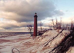
The Great Lakes are a huge part of Michigan's identity. They form most of the state's water boundaries. These lakes are Lake Erie, Lake Huron, Lake Michigan, and Lake Superior. Because shipping on these lakes has been so important throughout history, Michigan has about 150 lighthouses. That's more than any other state!
Michigan shares its southern land and water borders with Ohio and Indiana. To the north, its borders are almost entirely water. In Lake Michigan, it borders Illinois and Wisconsin. Then there's a land border with Wisconsin in the Upper Peninsula, mostly along the Menominee and Montreal Rivers. After that, the water borders continue in Lake Superior with Wisconsin and Minnesota to the west. Finally, the Canadian province of Ontario borders Michigan to the north and east across the lakes.
In southeastern Michigan, there's a water border with Canada along the St. Clair River, Lake St. Clair, and the Detroit River. This includes the Walpole Island First Nation reserve. The southeastern border ends in Lake Erie, where Michigan, Ohio, and Ontario meet.
Almost all of Michigan's rivers and streams flow into the Great Lakes. There are only two tiny exceptions on its borders.
Michigan has many islands in the Great Lakes. Some of the larger ones include Isle Royale and Grand Island in Lake Superior. In the St. Mary's River, you'll find Neebish and Sugar islands. Lake Huron has Drummond Island, the Les Cheneaux Islands, Mackinac Island, Bois Blanc Island, and Charity Island. In Lake Michigan, there's Beaver Island, the Fox Islands, North Manitou Island, and South Manitou Island. Harsens Island is in Lake St. Clair, and Belle Isle and Grosse Ile are in the Detroit River.
The Upper Peninsula has large bays like Keweenaw Bay, Whitefish Bay, and the Big and Little Bay de Noc. In the Lower Peninsula, you'll find the Grand and Little Traverse, Thunder, and Saginaw bays. Michigan has the second-longest shoreline of any state after Alaska, stretching about 3,288 miles (5,292 km). If you include all the islands, it adds another 1,056 miles (1,700 km) of shoreline!
Inland Lakes and Rivers
Michigan is truly a "water wonderland." It has 11,037 inland lakes, covering about 1,305 square miles (3,380 km2) of water. No spot in Michigan is more than 6 miles (9.7 km) from an inland lake. Also, no place is more than 85 miles (137 km) from one of the Great Lakes.
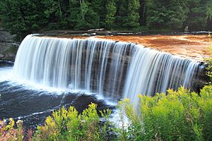
The state's many rivers are generally short and not very deep. However, many are great for recreational boating. Some of the main rivers include the Au Sable, Thunder Bay, Cheboygan, and Saginaw, all of which flow into Lake Huron. The Ontonagon and Tahquamenon rivers flow into Lake Superior. Rivers like the St. Joseph, Kalamazoo, Grand, Muskegon, Manistee, and Escanaba flow into Lake Michigan.
Protected Natural Areas

Michigan is home to many beautiful protected natural areas. The National Park Service manages three special places here:
- Isle Royale National Park: This park is on an island in Lake Superior, about 30 miles (48 km) southeast of Thunder Bay, Ontario.
- Pictured Rocks National Lakeshore: You can find this stunning area on the Lake Superior shore between Munising and Grand Marais.
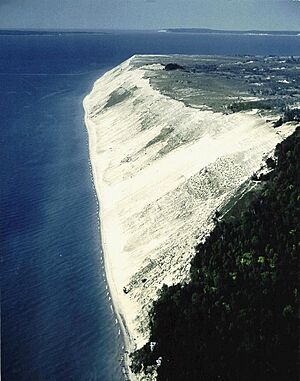
- Sleeping Bear Dunes National Lakeshore: This beautiful lakeshore is on the Lake Michigan shore, near the villages of Frankfort, Empire, and Glen Arbor.
Other national protected areas in Michigan include the Keweenaw National Historical Park, which tells the story of copper mining. There are also four large national forests: Huron National Forest, Manistee National Forest, Hiawatha National Forest, and Ottawa National Forest. Part of the long North Country National Scenic Trail also runs through Michigan.
Michigan has a huge system of state parks and forests. It has 78 state parks, 19 state recreation areas, and 6 state forests. This is the largest state park and forest system of any state! Some well-known examples are Holland State Park, Mackinac Island State Park, Au Sable State Forest, and Mackinaw State Forest.
Michigan's Climate
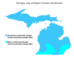
Michigan has a humid continental climate, which means it has warm summers and cold winters. However, there are two different climate regions within the state. The southern third of the Lower Peninsula has hotter summers and cold winters. The northern two-thirds of the Lower Peninsula and the entire Upper Peninsula have a more severe climate. This means they have warm but shorter summers and longer, very cold winters.
In the coldest months, from December through February (and even into early March in the far north), parts of Michigan often have average high temperatures below freezing. During winter, especially until mid-February, many parts of the state get a lot of lake-effect snow. This happens when cold air moves over the warmer Great Lakes, picking up moisture and dropping it as snow.
The state generally gets about 30 to 40 inches (76 to 100 cm) of precipitation each year. Snow cover can come and go in the southern part of the state. But in northern Lower Michigan and especially in the Upper Peninsula, the snow usually stays on the ground for a long time.
Michigan averages about 30 days with thunderstorms each year. These storms can be strong, especially in the southern part of the state. On average, Michigan has 17 tornadoes per year. These are more common in the very southern part of the state, which has historically been almost as vulnerable as parts of "Tornado Alley." Tornadoes are rare farther north in the Upper Peninsula.
Geology of Michigan
The ground beneath Michigan is very diverse. In the Upper Peninsula, you'll find very old, hard rocks, including sandstones, limestones, and rocks containing copper and iron. These rocks are similar to those found in parts of Canada. The central part of the Lower Peninsula has coal deposits and rocks from a later geological period. Older rock layers are found all over the state.
The soil in Michigan varies a lot. In large areas, especially in the south, the soil is very fertile and good for farming. However, most of the Upper Peninsula is rocky and mountainous, so the soil there isn't very good for agriculture. The climate in Michigan is made milder by being close to the Great Lakes. This means it's not as extreme as other places at the same latitude.
Michigan's Ecology and Forests
Michigan's forests are home to many different types of trees. Some of the main forest trees you'll see include basswood, maple, elm, sassafras, butternut, walnut, poplar, hickory, oak, willow, pine, birch, beech, hemlock, witchhazel, tamarack, cedar, locust, dogwood, and ash. These trees support a wide variety of wildlife and make Michigan a beautiful place to explore.
 | Janet Taylor Pickett |
 | Synthia Saint James |
 | Howardena Pindell |
 | Faith Ringgold |


