
National Register of Historic Places listings in Illinois facts for kids

Illinois is home to many amazing places that are super old and important! These places are listed on something called the National Register of Historic Places. It's like a special list of buildings, areas, and sites that tell us about the past.
There are over 1,900 of these special places in Illinois. Imagine that! Out of these, 85 are even more important. They are called National Historic Landmarks. You can find historic places in all 102 counties across Illinois. This list helps everyone know about and protect these cool spots.
Contents
- How Many Historic Places Are in Each County?
- Exploring Historic Sites in Illinois
- Bond County's Historic Buildings
- Boone County's Historic Districts
- Brown County's Historic Areas
- Cass County's Historic Sites
- Christian County's Historic Landmarks
- Clay County's Historic Buildings
- Clinton County's Historic Structures
- Cumberland County's Historic Sites
- DeWitt County's Historic Homes
- Douglas County's Historic Buildings
- Edwards County's Historic Church
- Effingham County's Historic Buildings
- Fayette County's Historic Sites
- Ford County's Historic Places
- Franklin County's Historic Buildings
- Hamilton County's Historic Sites
- Hardin County's Natural and Historic Gems
- Henderson County's Historic Places
- Iroquois County's Historic Buildings
- Jasper County's Historic Bridge
- Jefferson County's Historic Buildings
- Johnson County's Historic Sites
- Lawrence County's Historic Structures
- Marshall County's Historic Sites
- Mason County's Historic Places
- Massac County's Historic Sites
- Menard County's Lincoln Connections
- Moultrie County's Courthouse
- Perry County's Historic Sites
- Piatt County's Historic Areas
- Pope County's Historic Sites
- Pulaski County's Historic Sites
- Putnam County's Historic Buildings
- Richland County's Historic Places
- Saline County's Historic Sites
- Schuyler County's Historic Buildings
- Scott County's Historic Districts
- Shelby County's Historic Places
- Stark County's Historic Depot
- Wabash County's Historic House
- Washington County's Historic Buildings
- Wayne County's Historic Sites
- Williamson County's Historic Places
- Images for kids
How Many Historic Places Are in Each County?
Illinois has 102 counties, and every single one has at least one place on the National Register! Here's a quick look at how many historic sites are in each county:
| County | Number of Sites | |
|---|---|---|
| 1 | Adams | 27 |
| 2 | Alexander | 7 |
| 3 | Bond | 2 |
| 4 | Boone | 6 |
| 5 | Brown | 2 |
| 6 | Bureau | 14 |
| 7 | Calhoun | 7 |
| 8 | Carroll | 7 |
| 9 | Cass | 2 |
| 10 | Champaign | 58 |
| 11 | Christian | 6 |
| 12 | Clark | 9 |
| 13 | Clay | 6 |
| 14 | Clinton | 2 |
| 15 | Coles | 21 |
| 16.1 | Cook: Chicago | 363 |
| 16.2 | Cook: Evanston | 61 |
| 16.3 | Cook: Other | 125 |
| Cook: Duplicates | (1) | |
| Cook: Total | 548 | |
| 17 | Crawford | 7 |
| 18 | Cumberland | 3 |
| 19 | DeKalb | 15 |
| 20 | DeWitt | 2 |
| 21 | Douglas | 2 |
| 22 | DuPage | 46 |
| 23 | Edgar | 8 |
| 24 | Edwards | 1 |
| 25 | Effingham | 2 |
| 26 | Fayette | 4 |
| 27 | Ford | 5 |
| 28 | Franklin | 3 |
| 29 | Fulton | 43 |
| 30 | Gallatin | 7 |
| 31 | Greene | 12 |
| 32 | Grundy | 7 |
| 33 | Hamilton | 4 |
| 34 | Hancock | 12 |
| 35 | Hardin | 5 |
| 36 | Henderson | 4 |
| 37 | Henry | 15 |
| 38 | Iroquois | 5 |
| 39 | Jackson | 17 |
| 40 | Jasper | 1 |
| 41 | Jefferson | 2 |
| 42 | Jersey | 19 |
| 43 | Jo Daviess | 17 |
| 44 | Johnson | 3 |
| 45 | Kane | 73 |
| 46 | Kankakee | 14 |
| 47 | Kendall | 10 |
| 48 | Knox | 7 |
| 49 | LaSalle | 31 |
| 50 | Lake | 95 |
| 51 | Lawrence | 2 |
| 52 | Lee | 10 |
| 53 | Livingston | 13 |
| 54 | Logan | 12 |
| 55 | Macon | 10 |
| 56 | Macoupin | 8 |
| 57 | Madison | 40 |
| 58 | Marion | 8 |
| 59 | Marshall | 2 |
| 60 | Mason | 4 |
| 61 | Massac | 3 |
| 62 | McDonough | 8 |
| 63 | McHenry | 12 |
| 64 | McLean | 33 |
| 65 | Menard | 5 |
| 66 | Mercer | 11 |
| 67 | Monroe | 7 |
| 68 | Montgomery | 13 |
| 69 | Morgan | 9 |
| 70 | Moultrie | 1 |
| 71 | Ogle | 23 |
| 72 | Peoria | 34 |
| 73 | Perry | 2 |
| 74 | Piatt | 5 |
| 75 | Pike | 14 |
| 76 | Pope | 3 |
| 77 | Pulaski | 4 |
| 78 | Putnam | 4 |
| 79 | Randolph | 15 |
| 80 | Richland | 4 |
| 81 | Rock Island | 23 |
| 82 | St. Clair | 28 |
| 83 | Saline | 4 |
| 84 | Sangamon | 63 |
| 85 | Schuyler | 2 |
| 86 | Scott | 2 |
| 87 | Shelby | 6 |
| 88 | Stark | 1 |
| 89 | Stephenson | 17 |
| 90 | Tazewell | 17 |
| 91 | Union | 7 |
| 92 | Vermilion | 13 |
| 93 | Wabash | 1 |
| 94 | Warren | 10 |
| 95 | Washington | 3 |
| 96 | Wayne | 2 |
| 97 | White | 11 |
| 98 | Whiteside | 14 |
| 99 | Will | 36 |
| 100 | Williamson | 5 |
| 101 | Winnebago | 36 |
| 102 | Woodford | 8 |
| (duplicates) | (9) | |
| Total: | 1,844 | |
Exploring Historic Sites in Illinois
Let's look at a few examples of the cool historic places you can find in Illinois!
Bond County's Historic Buildings
Bond County has two special places on the National Register.
- Greenville Public Library: This library, built in 1905, is a beautiful old building where people still go to read and learn. It was added to the list in 1995.
- Old Main, Almira College: This building, now called Hogue Hall, is part of Greenville College. It was built in 1856 and became a historic place in 1975. It's a great example of old college architecture.
Boone County's Historic Districts
Boone County has six historic places. Two of them are entire historic districts!
- Belvidere North State Street Historic District: This area along State Street in Belvidere is special because of its historic buildings. It was added to the list in 2012.
- Belvidere South State Street Historic District: Another part of State Street in Belvidere, this district also has many important old buildings. It joined the list in 2012.
- Belvidere High School: This old high school building, located at Pearl and First Streets, was built in 1894. It became a historic site in 1997.
- Lampert-Wildflower House: This house at 410 E. Lincoln Ave. in Belvidere was added to the list in 2005. It's a beautiful example of historic homes.
- Pettit Memorial Chapel: Found at 1100 N. Main St. in Belvidere, this chapel was built in 1907. It's known for its unique design and was listed in 1978.
- United States Post Office-Belvidere: This post office building at 200 S. State St. in Belvidere was built in 1911. It became a historic site in 2000.
Brown County's Historic Areas
Brown County has two historic places on the list.
- La Grange Lock and Dam Historic District: This district includes a lock and dam on the Illinois River near Versailles. It's an important part of the state's transportation history and was listed in 2004.
- Mount Sterling Commercial Historic District: This area in Mount Sterling includes many historic businesses and the Brown County Courthouse. It was added to the list in 1987.
Cass County's Historic Sites
Cass County has two historic places.
- Beardstown Grand Opera House: This beautiful opera house at 121 State St. in Beardstown was built in 1872. It became a historic site in 2000.
- Andrew Cunningham Farm: This farm, located east of Virginia, is a historic rural property. It was added to the list in 1975.
Christian County's Historic Landmarks
Christian County has six historic places.
- Bolivia Road Bridge: This bridge crosses the North Fork of the Sangamon River near Bolivia. It's an old bridge that was listed in 2004.
- Illinois State Bank Building: Located at 201 N. Chestnut St. in Assumption, this bank building is a historic landmark. It was added to the list in 1984.
- Louis Jehle House: This house at 511 E. 5th St. in Pana is a historic home. It was listed in 1995.
- Kitchell Park: This park in Pana, at the junction of 9th and Kitchell Streets, is a historic district. It was added to the list in 1992.
- Taylorville Chautauqua Auditorium: Found in Manners Park in Taylorville, this auditorium was built in 1914. It's a historic place where people gathered for education and entertainment. It was listed in 1988.
- Taylorville Courthouse Square Historic District: This area around the courthouse in Taylorville is a historic district with many important buildings. It was added to the list in 1985.
Clay County's Historic Buildings
Clay County has six historic places.
- Baltimore and Ohio Railroad Depot: This old train station at 225 W. Railroad St. in Flora was built in 1912. It became a historic site in 1998.
- Clay County Courthouse: The courthouse at 300 Broadway St. in Louisville is a grand building. It was added to the list in 2015.
- Clay County Jail: This old jail at 195 Main St. in Louisville was built in 1891. It became a historic place in 1998.
- Pearl and Bess Meyer House: This house at 233 E. 2nd St. in Flora was listed in 2001.
- Paine House: Located near Xenia, this house was added to the list in 1985.
- Shriver House: This house at 117 E. 3rd St. in Flora was listed in 1983.
Clinton County's Historic Structures
Clinton County has two historic places.
- General Dean Suspension Bridge: This bridge crosses the Kaskaskia River east of Carlyle. It's a unique suspension bridge and was listed in 1973.
- James C. Twiss House: This house at 298 N. Page St. in Aviston was added to the list in 2010.
Cumberland County's Historic Sites
Cumberland County has three historic places.
- Cumberland County Courthouse: The courthouse in Toledo was built in 1888. It became a historic site in 1981.
- Greenup Commercial Historic District: This area in Greenup has many historic commercial buildings. It was added to the list in 1991.
- Thornton Ward Estate: This estate on U.S. Route 40 near Toledo was listed in 2001.
DeWitt County's Historic Homes
DeWitt County has two historic homes.
- Magill House: This house at 100 N. Center St. in Clinton was added to the list in 2003.
- C. H. Moore House: Located at 219 E. Woodlawn St. in Clinton, this house was listed in 1979.
Douglas County's Historic Buildings
Douglas County has two historic places.
- Arcola Carnegie Public Library: This library at 407 E. Main St. in Arcola was built in 1905 with money from Andrew Carnegie. It became a historic site in 2002.
- Streibich Blacksmith Shop: This old blacksmith shop at 1 N. Howard St. in Newman was listed in 1991.
Edwards County's Historic Church
Edwards County has one historic place.
- St. John's Episcopal Church: This church at 20 E. Cherry St. in Albion was built in 1841. It's a very old church and was listed in 2012.
Effingham County's Historic Buildings
Effingham County has two historic places.
- Effingham County Courthouse: The courthouse at 110 E. Jefferson St. in Effingham was built in 1871. It became a historic site in 1985.
- Dr. Charles M. Wright House: This house at 3 W. Jackson St. in Altamont was listed in 1986.
Fayette County's Historic Sites
Fayette County has four historic places.
- Floyd and Glenora Dycus House: This house at 305 S. Second St. in Brownstown was listed in 2001.
- First Presbyterian Church: This church at 301 W. Main St. in Vandalia was built in 1868. It became a historic site in 1982.
- Little Brick House: This small brick house at 621 St. Clair St. in Vandalia was listed in 1973.
- Vandalia Statehouse: This building at 315 W. Gallatin St. in Vandalia was the fourth state capitol building of Illinois. It was built in 1836 and became a historic site in 1974.
Ford County's Historic Places
Ford County has five historic places.
- Dunnan-Hampton House: This house at 511 W. Pells St. in Paxton was listed in 2007.
- Paxton Carnegie Public Library: This library at 254 S. Market St. in Paxton was built in 1904. It became a historic site in 2002.
- Paxton First Schoolhouse: This old schoolhouse at 406 E. Franklin St. in Paxton was listed in 1980.
- Paxton Water Tower and Pump House: This water tower and pump house at 145 S. Market St. in Paxton were listed in 1984.
- Alfred Phillips House: This house at 404 N. Melvin St. in Gibson City was listed in 1999.
Franklin County's Historic Buildings
Franklin County has three historic places.
- Franklin County Jail: This old jail at 209 W. Main St. in Benton was built in 1905. It became a historic site in 1999.
- Sesser Opera House: This opera house at 106 W. Franklin St. in Sesser was listed in 1982.
- West Frankfort City Hall: This city hall building at 108 N. Emma St. in West Frankfort was listed in 2002.
Hamilton County's Historic Sites
Hamilton County has four historic places.
- Cloud State Bank: This bank at 108 S. Washington St. in McLeansboro was listed in 1978.
- Aaron G. Cloud House: This house at 164 S. Washington St. in McLeansboro was listed in 1978.
- Chalon Guard and Emma Blades Cloud House: This house at 300 S. Washington St. in McLeansboro was listed in 2009.
- St. James Episcopal Church: This church at 111 N. Pearl St. in McLeansboro was listed in 1995.
Hardin County's Natural and Historic Gems
Hardin County has five historic places, including some cool natural spots!
- Battery Rock: This unique rock formation on the Ohio River near Cave-in-Rock was listed in 1998.
- Cave-in-Rock: This famous cave, located north of the town of Cave-In-Rock, is a natural landmark with a rich history. It became a historic site in 1998.
- Illinois Iron Furnace: Located in the Shawnee National Forest near Rosiclare, this old iron furnace was listed in 1973. It shows how iron was made long ago.
- Orr-Herl Mound and Village Site: This ancient site on the Ohio River near Rosiclare tells us about early Native American life. It was listed in 1978.
- Rose Hotel: This historic hotel on S. Main St. in Elizabethtown was listed in 1972.
Henderson County's Historic Places
Henderson County has four historic places.
- Lock and Dam No. 18 Historic District: This lock and dam on the Mississippi River near Gladstone is an important part of river transportation history. It was listed in 2004.
- Oquawka Wagon Bridge: This bridge over Henderson Creek south of Oquawka was listed in 1975.
- Alexis Phelps House: This house on the Mississippi River in Oquawka was listed in 1982.
- South Henderson Church and Cemetery: This church and cemetery east of Gladstone were listed in 1976.
Iroquois County's Historic Buildings
Iroquois County has five historic places.
- Old Iroquois County Courthouse: This old courthouse at Cherry St. and 2nd St. in Watseka was built in 1866. It became a historic site in 1975.
- Prairie Dell Meetinghouse: This meetinghouse near Iroquois was listed in 2005.
- A. Herr and E. E. Smith Public Library: This library at 105 Adams St. in Loda was listed in 1995.
- St. Mary's Church: This church at 308 St. Charles Ave. in Beaverville was listed in 1996.
- Watseka Union Depot: This train depot on S. 2nd St. in Watseka was listed in 1999.
Jasper County's Historic Bridge
Jasper County has one historic place.
- Embarras River Bridge: This bridge over the Embarras River near Newton was listed in 1998.
Jefferson County's Historic Buildings
Jefferson County has two historic places.
- Appellate Court, 5th District: This court building at 14th and Main Sts. in Mount Vernon was listed in 1973.
- C. H. Judd House: This house near Belle Rive was listed in 1983.
Johnson County's Historic Sites
Johnson County has three historic places.
- John Dupont House: This house at 130 W. 5th St. in New Burnside was listed in 2016.
- Johnson County Courthouse: The courthouse in Vienna was listed in 2010.
- Vienna Public Library: This library at 401 Poplar St. in Vienna was listed in 1995.
Lawrence County's Historic Structures
Lawrence County has two historic places.
- Bridge at Thirteenth Street: This bridge in St. Francisville was listed in 2016.
- Lawrence County Courthouse: The courthouse at 1100 State St. in Lawrenceville was listed in 2010.
Marshall County's Historic Sites
Marshall County has two historic places.
- Marshall Site: This site near Chillicothe was listed in 2014.
- Robert Waugh House: This unique octagon-shaped house at 202 School St. in Sparland was listed in 1978.
Mason County's Historic Places
Mason County has four historic places.
- Clear Lake Site: This site near Manito was listed in 1978.
- Havana Public Library: This library at 201 W. Adams St. in Havana was listed in 1994.
- Havana Water Tower: This water tower in Havana was listed in 1993.
- Rockwell Mound: This ancient mound in Rockwell Park in Havana was listed in 1987.
Massac County's Historic Sites
Massac County has three historic places.
- Elijah P. Curtis House: This house at 405 Market St. in Metropolis was listed in 1978.
- Fort Massac Site: This historic fort site southeast of Metropolis on the Ohio River was listed in 1971.
- Kincaid Site: This important ancient site near Brookport was listed in 1966. It's a National Historic Landmark.
Menard County's Lincoln Connections
Menard County has five historic places, including some related to Abraham Lincoln!
- Lincoln's New Salem Village: This village south of Petersburg is a recreated village where Abraham Lincoln lived as a young man. It was listed in 1972.
- North Sangamon United Presbyterian Church: This church north of Athens was listed in 1979.
- Petersburg Historic District: This historic area in Petersburg was listed in 1976.
- Robinson-Bonnett Inn: This inn near Bobtown was listed in 1990.
- Col. Matthew Rogers Building: This building at 200 S. Main St. in Athens was listed in 2005.
Moultrie County's Courthouse
Moultrie County has one historic place.
- Moultrie County Courthouse: The courthouse at 10 S. Main St. in Sullivan was listed in 1995.
Perry County's Historic Sites
Perry County has two historic places.
- Du Quoin State Fairgrounds: This fairgrounds north of Du Quoin was listed in 1990.
- Perry County Jail: This old jail at 108 W. Jackson St. in Pinckneyville was listed in 2000.
Piatt County's Historic Areas
Piatt County has five historic places.
- Robert Allerton Estate: This beautiful estate at 515 Old Timber Rd. in Monticello was listed in 2007.
- Monticello Courthouse Square Historic District: This historic area around the courthouse in Monticello was listed in 2009.
- North State Street Historic District: This area along North State Street in Monticello was listed in 1998.
- South Charter Street Historic District: This historic area in Monticello was listed in 2002.
- Voorhies Castle: This unique building south of Bement was listed in 1979.
Pope County's Historic Sites
Pope County has three historic places.
- Golconda Historic District: This historic area in Golconda was listed in 1976.
- Kincaid Site: This important ancient site near Brookport was listed in 1966. It's a National Historic Landmark.
- Millstone Bluff: This site near Glendale was listed in 1973.
Pulaski County's Historic Sites
Pulaski County has four historic places.
- Illinois Central Railroad Depot: This train station at Central Ave. and Ullin Ave. in Ullin was listed in 1999.
- Mound City Civil War Naval Hospital: This hospital at Commercial Ave. and Central St. in Mound City was listed in 1974.
- Mound City National Cemetery: This cemetery at the junction of U.S. Route 51 and Illinois Route 37 in Mound City was listed in 1997.
- Olmstead Depot: This train depot at Front St. and Caledonia Ave. in Olmsted was listed in 1989.
Putnam County's Historic Buildings
Putnam County has four historic places.
- Clear Creek Meeting House: This meeting house at 14365 N. 350th Ave. in McNabb was listed in 1992.
- Cortland Condit House: This house off Illinois Route 29 in Putnam was listed in 1983.
- Edward Pulsifer House: This house on Illinois Route 71 in Hennepin was listed in 1979.
- Putnam County Courthouse: The courthouse at 4th St. in Hennepin was listed in 1975.
Richland County's Historic Places
Richland County has four historic places.
- Elliott Street Historic District: This historic area on S. Elliott St. in Olney was listed in 1980.
- Ambrose Hopkinson House: This house at 122 W. Elm St. in Olney was listed in 2001.
- Larchmound: This property at 1030 S. Morgan St. in Olney was listed in 1980.
- Olney Carnegie Library: This library at 401 E. Main St. in Olney was listed in 2002.
Saline County's Historic Sites
Saline County has four historic places.
- Carrier Mills Archeological District: This ancient site along the Saline River south of Carrier Mills was listed in 1978.
- Eldorado City Hall: This city hall at 1604 Locust St. in Eldorado was listed in 1995.
- Harrisburg City Hall: This city hall at 110 E. Locust in Harrisburg was listed in 1998.
- Saline County Poor Farm: This farm at 1600 Feazel Rd. in Harrisburg was listed in 2001.
Schuyler County's Historic Buildings
Schuyler County has two historic places.
- Phoenix Opera House Block: This block of buildings at 112-122 W. Lafayette St. in Rushville was listed in 1985.
- White Oak Hall: This hall near Rushville was listed in 2003.
Scott County's Historic Districts
Scott County has two historic places.
- Naples Archeological District: This ancient site on the Illinois River south of Naples was listed in 1979.
- Winchester Historic District: This historic area in Winchester was listed in 1979.
Shelby County's Historic Places
Shelby County has six historic places.
- Chautauqua Auditorium: This auditorium in Forest Park in Shelbyville was listed in 1978.
- Clarksburg Schoolhouse: This old schoolhouse near Clarksburg was listed in 2001.
- Shelbyville Historic District: This historic area in Shelbyville was listed in 1976.
- Horace M. Tallman House: This house at 816 W. Main in Shelbyville was listed in 1988.
- Thompson Mill Covered Bridge: This covered bridge over the Kaskaskia River northeast of Cowden was listed in 1975.
- Westervelt Christian Church: This church at 103 W. Main St. in Westervelt was listed in 2006.
Stark County's Historic Depot
Stark County has one historic place.
- Chicago, Burlington & Quincy Railroad Depot: This old train station on Williams St. in Wyoming was listed in 1987.
Wabash County's Historic House
Wabash County has one historic place.
- Beall-Orr House: This house at 503 Cherry St. in Mt. Carmel was listed in 1994.
Washington County's Historic Buildings
Washington County has three historic places.
- Louisville and Nashville Depot: This train station at 101 E. Railroad St. in Nashville was listed in 1985.
- Original Springs Hotel and Bathhouse: This hotel at 506 N. Hanover St. in Okawville was listed in 1978.
- Frank Schlosser Complex: This complex on W. Walnut St. in Okawville was listed in 1983.
Wayne County's Historic Sites
Wayne County has two historic places.
- G.J. George House: This house at 205 W. Center in Fairfield was listed in 2006.
- Mayberry Mound and Village Site: This ancient site northeast of Sims was listed in 1978.
Williamson County's Historic Places
Williamson County has five historic places.
- Willis Allen House: This house at 514 S. Market St. in Marion was listed in 1982.
- Goddard Chapel: This chapel in Rose Hill Cemetery in Marion was listed in 1986.
- Marion Veterans Administration Hospital Historic District: This hospital district at 2401 W. Main St. in Marion was listed in 2013.
- Ed M. Stotlar House: This house at 1304 W. Main St. in Marion was listed in 2002.
- Williamson County Jail: This old jail at 105 S. Van Buren St. in Marion was listed in 2007.
Images for kids
-
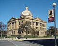
Lincoln Courthouse Square Historic District, Logan County
-
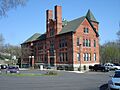
East Dubuque School, Jo Daviess County
-
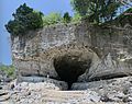
Cave-In-Rock, Hardin County
-

Illinois State Capitol, Sangamon County
-
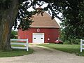
Dennis Otte Round Barn, Stephenson County
-
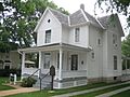
Ronald Reagan Boyhood Home, Lee County
-
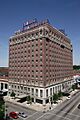
Pere Marquette Hotel, Peoria County
-
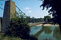
General Dean Suspension Bridge, Clinton County


