Age of Discovery facts for kids
The Age of Discovery or Age of Exploration was a period from the early 15th century that continued into the early 17th century, during which European ships traveled around the world to search for new trading routes and partners.
They were in search of trading goods such as gold, silver, and spices. In the process, Europeans met people and mapped lands previously unknown to them. Among the most famous explorers of the period were Christopher Columbus, Vasco da Gama, Pedro Álvares Cabral, John Cabot, Juan Ponce de León, Juan Sebastian Elcano, Bartholomeu Dias, Ferdinand Magellan, Willem Barentsz, Abel Tasman, Jean Alfonse, Jacques Cartier, Samuel de Champlain, Willem Blaeu, and Captain James Cook.
Contents
Portuguese Empire
Henry the Navigator started by paying Portuguese sailors to explore the west coast of Africa. In 1419, João Gonçalves Zarco discovered the Madeira Islands. Later in the 15th century, Vasco da Gama reached the southwestern tip of Africa and established the city of Cape Town, a Portuguese colony. This opened the way to the Indian Ocean. In the next two centuries, the Portuguese created a great trading empire on the coasts of Africa, the Arabian Peninsula, and India. The Portuguese Empire eventually weakened after the Dutch East India Company rose as the major power in Indian Ocean trade.
Spanish Empire
In a hurry to compete with Portugal for a colonial empire, Spain sent Christopher Columbus in the opposite direction of the Portuguese. Instead of going south along the west coast of Africa, Columbus sailed across the Atlantic Ocean. When his ships landed, he believed that he had come to Asia. Later, some Spanish sailors found out that this land was a different continent than Asia. It is now called the Americas.
In the 16th century, Spanish conquistadores gained the whole of what later became Latin America, except some British and French colonies in northeastern South America, and Brazil, which belonged to Portugal. The Spanish concentrated on conquest, unlike the Portuguese who focused on trading. They eventually developed a vast colonial empire, in contrast to the Portuguese who ruled a few islands and coastal cities along the Indian Ocean. When Spain and Portugal were united under King Philip II of Spain, their combined empire was the largest on earth.
In 1522, the fleet of Ferdinand Magellan returned to Spain. The survivors were the first ever to sail around the world.
Britain, France, and the Netherlands
In the 17th century, political and religious wars with Britain, France, and the Netherlands weakened the Iberian Peninsula. These three nations emerged as the main winners of the wars and became major powers like Spain and Portugal. In the next two centuries, the world became a battlefield of the three nations. Britain and France held land in North America, India, and other distant places. The Dutch colonized smaller parts of the Americas, took the former Portuguese trading centers around the Indian Ocean, and conquered Indonesia. These three new great powers also had influence all around the world.
Eventually, the result was a series of wars that were fought both in Europe and overseas, with Britain emerging victorious. The British took the former land of French Canada and India in the 18th century. They seized power in the Indian Ocean and defeated the Dutch navy. By 1763, the British Empire had become the second global empire after Spain. However, in 1776, thirteen colonies of British America declared independence. With help from the French, Dutch, and Spanish, they defeated Britain in the American Revolution.
Exploration of the Southern Pacific Ocean
In 1778, Captain James Cook of Britain sailed across the South Pacific Ocean looking for a mysterious continent in the Southern Hemisphere. He landed on two large islands. Then he sailed west and found a bigger piece of land. The first, was modern New Zealand; the second was Australia. Captain Cook claimed these lands for Britain. He then explored the Pacific world for another year and died in a fight with the Hawaiians.
Effects of the Age of Discovery
Many slaves brought from Africa were brought to the Americas, which was claimed to be found by Christopher Columbus himself. In conclusion, the Portuguese were weakened after the Dutch rose in the Indian Ocean trade route. Spain gained almost all of Latin America and a massive amount of silver.
When Christopher Columbus tried to find a new trade route to Asia, he thought that he could travel around the world. Instead, he had found a New World. Vikings had briefly visited Vinland around 1000 A.D.
Interesting facts about the Age of Discovery
- Niccolò de' Conti traveled for 25 years, from 1414 to 1439, and suggested that it is possible to reach Asia by sailing around Africa.
- The Ottoman Empire helped to bring about the Age of Discovery. When they conquered Constantinople, they forced Europeans to search for other trade routes to Asia.
- Poland's forests were cleared to build the ships necessary to sail to the East Indies.
- It is speculated that Columbus's ship captain, Rodrigo de Triana, was the first to spot the New World.
- Sailor's meals were made from food that would not spoil and prepared months in advance.
- Abel Tasman, the European often credited with discovering New Zealand, missed Australia the first time he sailed in the area.
- Although Ireland is known for its potatoes, Sir Walter Raleigh is credited with bringing them to Ireland after they were discovered in Peru by the Spanish.
- The Pilgrims at Plymouth Colony were greeted in English by a Native Wampanoag.
- European explorers brought diseases to the New World that the natives had never experienced.
Related pages
Images for kids
-
The Portuguese invention of the caravel, which was maneuverable and able to undertake ocean voyages, was essential to European maritime exploration. The present image shows the "Caravela Vera Cruz", navigating the Tagus river, Lisboa.
-
The Nao Victoria was the Spanish ship that managed to carry out the first circumnavigation in history. The present image shows a replica of Victoria, built in 1992, visiting Nagoya, Japan, for Expo 2005.
-
Ptolemy's world map (2nd century) in a 15th-century reconstruction by Nicolaus Germanus.
-
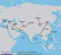
The Silk Road and spice trade routes later blocked by the Ottoman Empire in 1453 spurring exploration to find alternative sea routes
-
Marco Polo travels (1271–1295)
-
"Mao Kun map", believed to be based on Zheng He's travels, showing sailing directions between ports of SE Asia and as far as Malindi, in Wu Bei Zhi (1628)
-
Saharan trade routes c. 1400, with modern Niger highlighted
-
Replica of caravel ship introduced in the mid-15th century for oceanic exploration
-
The 1494 Tordesilhas Treaty meridian (purple) and the later Maluku Islands antimeridian (green), set at the Treaty of Zaragoza (1529)
-
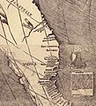
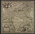
Americae Sive Quartae Orbis Partis Nova Et Exactissima Descriptio by Diego Gutiérrez, the largest map of the Americas until the 17th century, and the first map to use the name "California". British Library, London.
-
Vasco da Gama's 1497–1499 travel to India (black). Previous travels of Pêro da Covilhã (orange) and Afonso de Paiva (blue), and their common route (green)
-
Outward and return voyages of the Portuguese India Armadas in the Atlantic and the Indian oceans, with the North Atlantic Gyre (Volta do mar) picked up by Henry's navigators, and the outward route of the South Atlantic westerlies that Bartolomeu Dias discovered in 1488, followed and explored by the expeditions of Vasco da Gama and Pedro Alvares Cabral
-
Vasco Núñez de Balboa's travel to the "South Sea", 1513
-
Victoria, the single ship to have completed the first world circumnavigation. (Detail from Maris Pacifici by Ortelius, 1589.)
-
Map of the island city Tenochtitlán and Mexico gulf made by one of Cortés' men, 1524, Newberry Library, Chicago
-
Francisco Pizarro's route of exploration during the conquest of Peru (1531–1533)
-
Portuguese trade routes (blue) and the rival Manila-Acapulco galleons trade routes (white) established in 1568
-
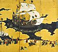
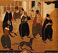
Portuguese carrack in Nagasaki, Nanban art attributed to Kanō Naizen, 1570–1616 Japan
-
In 1570 (May 20) Gilles Coppens de Diest at Antwerp published 53 maps created by Abraham Ortelius under the title Theatrum Orbis Terrarum, considered the "first modern atlas". Three Latin editions of this (besides a Dutch, a French and a German edition) appeared before the end of 1572; the atlas continued to be in demand till about 1612. This is the world map from this atlas.
-
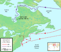
Map of Henry Hudson's 1609–1611 voyages to North America for the Dutch East India Company (VOC)
-
Henry Hudson's ship Halve Maen in the Hudson River
-
1599 map of Arctic exploration by Willem Barentsz in his third voyage
-
The route of Abel Tasman's 1642 and 1644 voyages in New Holland (Australia) in the service of the VOC (Dutch East India Company)
-
Duyfken replica, Swan River, Australia
-
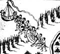
Yermak Timofeyevich and his band of adventurers crossing the Ural Mountains at Tagil, entering Asia from Europe
-
A map of Irkutsk and Lake Baikal in its neighbourhood, as depicted in the late-17th-century Remezov Chronicle
-
A 17th-century koch in a museum in Krasnoyarsk. Kochi were the earliest icebreakers and were widely used by Russians in the Arctic and on Siberian rivers.
-
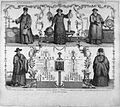
Jesuit scholars collaborated extensively with Chinese astronomers, introducing Copernican principles. Top: Matteo Ricci, Adam Schaal and Ferdinand Verbiest (1623–1688); Bottom: Paul Siu (Xu Guangqi), Colao or Prime Minister of State, and his granddaughter Candide Hiu
-
World map from Johannes Kepler's Rudolphine Tables (1627), incorporating many of the new discoveries.
-
Jan Davidsz. de Heem, detail of silverware from A Richly Laid Table with Parrots, c. 1650
See also
 In Spanish: Era de los Descubrimientos para niños


