
Arkansas facts for kids
Quick facts for kids
Arkansas
|
|||
|---|---|---|---|
|
|||
| Nicknames:
The Natural State (current)
Land of Opportunity (former) |
|||
| Motto(s):
Regnat populus (Latin: The People Rule)
|
|||
| Anthem: "Arkansas", "Arkansas (You Run Deep in Me)", "Oh, Arkansas", and "The Arkansas Traveler" | |||

Location of Arkansas within the United States
|
|||
| Country | United States | ||
| Before statehood | Arkansas Territory | ||
| Admitted to the Union | June 15, 1836 (25th) | ||
| Capital (and largest city) |
Little Rock | ||
| Largest county or equivalent | Pulaski | ||
| Largest metro and urban areas | Central Arkansas Northwest Arkansas | ||
| Legislature | Arkansas General Assembly | ||
| • Upper house | Senate | ||
| • Lower house | House of Representatives | ||
| Judiciary | Arkansas Supreme Court | ||
| U.S. senators | John Boozman (R) Tom Cotton (R) |
||
| U.S. House delegation | 4 Republicans (list) | ||
| Area | |||
| • Total | 53,179 sq mi (137,732 km2) | ||
| • Land | 52,035 sq mi (134,771 km2) | ||
| • Water | 1,143 sq mi (2,961 km2) 2.15% | ||
| Area rank | 29th | ||
| Dimensions | |||
| • Length | 240 mi (386 km) | ||
| • Width | 270 mi (435 km) | ||
| Elevation | 650 ft (200 m) | ||
| Highest elevation | 2,753 ft (839 m) | ||
| Lowest elevation
(Ouachita River at Louisiana border)
|
55 ft (17 m) | ||
| Population
(2024)
|
|||
| • Total | |||
| • Rank | 33rd | ||
| • Density | 57.9/sq mi (22.4/km2) | ||
| • Density rank | 34th | ||
| • Median household income | $58,700 (2023) | ||
| • Income rank | 48th | ||
| Demonym(s) | Arkansan Arkansawyer Arkanite |
||
| Language | |||
| • Official language | English | ||
| Time zone | UTC−06:00 (Central) | ||
| • Summer (DST) | UTC−05:00 (CDT) | ||
| USPS abbreviation |
AR
|
||
| ISO 3166 code | US-AR | ||
| Traditional abbreviation | Ark. | ||
| Latitude | 33° 00′ N to 36° 30′ N | ||
| Longitude | 89° 39′ W to 94° 37′ W | ||


| Dance | Square dance |
|---|---|
| Bird | Mockingbird |
| Flower | Apple blossom |
| Tree | Pine tree |
| Insect | Western honeybee |
| Vegetable | South Arkansas vine ripe pink tomato |
Arkansas is a state in the South Central United States that does not touch the ocean. It shares borders with Missouri to the north, Tennessee and Mississippi to the east, Louisiana to the south, and Texas and Oklahoma to the west. The state's name comes from the Osage language, a Siouan language. It refers to their relatives, the Quapaw people.
Arkansas has many different types of land. You can find mountains like the Ozark and Ouachita Mountains. There are also thick forests in the south called the Arkansas Timberlands. In the east, you'll find lowlands along the Mississippi River and the Arkansas Delta.
Arkansas is the 29th largest state by area. It is also the 34th most populated state. In 2020, it had just over 3 million people. Little Rock is the capital and largest city. It is in the middle of the state. Little Rock is a major center for travel, business, culture, and government.
The northwestern part of the state is also a big center for people, education, and business. This area includes the Fayetteville–Springdale–Rogers Metropolitan Area and the Fort Smith metropolitan area. Jonesboro is the largest city in eastern Arkansas. Pine Bluff is the largest city in the southeastern part.
Arkansas was once part of French Louisiana. It became part of the U.S. with the Louisiana Purchase. The Territory of Arkansas joined the U.S. as the 25th state on June 15, 1836. Many cotton farms were in the Delta region. These farms relied on the labor of enslaved African Americans.
In 1861, Arkansas left the United States. It joined the Confederate States of America during the American Civil War. After rejoining the U.S. in 1868, Arkansas struggled economically. This was because it depended too much on large farms. Cotton was the main crop, but its price went down. The state did not try new industries, so it fell behind. In the late 1800s, Arkansas passed laws that separated people by race. These laws also prevented African Americans from voting. During the civil rights movement in the 1950s and 1960s, Arkansas was important. Little Rock was a key place for efforts to integrate schools.
After World War II in the 1940s, Arkansas's economy started to grow and change. In the 1960s, the Walmart company started in the state. Walmart is now the world's largest company by revenue. Its main office is in Bentonville. Today, Arkansas's economy includes service jobs, aircraft, poultry, steel, and tourism. Important crops are cotton, soybeans, and rice.
Arkansas's culture can be seen in its museums, theaters, and restaurants. Many famous people are from Arkansas. These include former president Bill Clinton, singer Johnny Cash, and poet Maya Angelou.
Contents
- Understanding the Name "Arkansas"
- Exploring Arkansas's Geography
- A Look at Arkansas's History
- Major Cities and Towns
- How Arkansas's Government Works
- People and Population in Arkansas
- Arkansas's Economy
- Arkansas's Culture
- Fun Places to Visit in Arkansas
- Learning in Arkansas: Education
- Getting Around Arkansas: Transportation
- Images for kids
- See also
Understanding the Name "Arkansas"
The name Arkansas comes from the same word as the state of Kansas. The Kansa tribe of Native Americans are related to the Sioux tribes. The word "Arkansas" is a French way of saying "Arcansas." This comes from a Quapaw word, akakaze. It means "land of downriver people." It could also come from a Sioux word meaning "people of the south wind."
Exploring Arkansas's Geography


Arkansas's Borders
Arkansas shares borders with Louisiana to the south and Texas to the southwest. To the west is Oklahoma, and to the north is Missouri. Tennessee and Mississippi are to the east. The United States Census Bureau says Arkansas is a southern state.
The Mississippi River forms most of Arkansas's eastern border. However, in some places, the river has changed its path. This makes the exact border with Mississippi sometimes unclear.
Arkansas's Land and Mountains
Arkansas can be divided into two main parts. The northwest has highlands, and the southeast has lowlands. The highlands are part of the Southern Interior Highlands. They include The Ozarks and the Ouachita Mountains. The lowlands include the Gulf Coastal Plain and the Arkansas Delta.
The southeastern part of Arkansas, along the Mississippi Alluvial Plain, is called the Arkansas Delta. This area is flat with rich soil from river floods. Farther from the river, the Grand Prairie has gently rolling land. Both are good for farming. The Delta region is cut by a landform called Crowley's Ridge. This is a narrow band of hills that rise about 250 to 500 feet above the flat land. Many major towns in eastern Arkansas are on Crowley's Ridge.
Northwest Arkansas is part of the Ozark Plateau and Ozark Mountains. To the south are the Ouachita Mountains. The Arkansas River separates these two mountain ranges. The southern and eastern parts of Arkansas are called the Lowlands. These mountain ranges are the only major mountains between the Rocky Mountains and the Appalachian Mountains. The highest point in Arkansas is Mount Magazine. It is in the Ouachita Mountains and is 2,753 feet above sea level.
Rivers and Lakes in Arkansas

Arkansas has many rivers, lakes, and reservoirs. Major rivers that flow into the Mississippi River include the Arkansas River, the White River, and the St. Francis River. The Arkansas River gets water from the Mulberry River and the Fourche LaFave River. These rivers are in the Arkansas River Valley, where Lake Dardanelle is also located.
The Buffalo River, Little Red River, Black River, and Cache River all flow into the White River. The White River then empties into the Mississippi. In southern Arkansas, the Saline River, Little Missouri River, Bayou Bartholomew, and Caddo River all flow into the Ouachita River. The Ouachita River eventually flows into the Mississippi in Louisiana. The Red River forms a small part of the state's border with Texas.
Arkansas has few natural lakes. It has many man-made lakes called reservoirs. Some of these are Bull Shoals Lake, Lake Ouachita, Greers Ferry Lake, and Beaver Lake.
Arkansas is also home to many caves, like Blanchard Springs Caverns. Over 43,000 Native American sites have been found. Many are ancient burial mounds and rock shelters. Crater of Diamonds State Park near Murfreesboro is special. It is the only place in the world where the public can dig for diamonds. Arkansas also has 12 Wilderness Areas. These are protected areas for outdoor fun like hiking and fishing.
Plants and Animals of Arkansas

Arkansas has three main natural regions. These are the Ozark, Ouachita-Appalachian Forests, Mississippi Alluvial and Southeast USA Coastal Plains, and the Southeastern USA Plains. The state also has two main types of forests: subtropical coniferous and temperate deciduous.
In 2010, a survey found that 56% of Arkansas's land is forest. This is about 18.7 million acres. The main trees in Arkansas's forests are oak, hickory, and pine trees.
Arkansas's plant life changes with the climate and elevation. The pine forests in the south have many oak, hickory, and pine trees. In eastern Arkansas, you can find cypress and water oaks. These trees grow with their roots in the water of the Mississippi Valley. Crowley's Ridge is home to the tulip tree, which is rare in the state. It also has trees usually found in the northeast, like the beech tree. The northwestern highlands have a mix of oak and hickory trees. You can also find Ozark white cedars, dogwoods, and redbuds. The higher peaks in the Arkansas River Valley have many ferns.
Arkansas's Climate

.jpg)
Arkansas generally has a humid subtropical climate. Even though it doesn't touch the Gulf of Mexico, it's close enough for the warm water to affect its weather. Summers in Arkansas are usually hot and humid. Winters are a bit drier, with mild to cool temperatures.
Arkansas is known for its extreme weather. A typical year can bring thunderstorms, tornadoes, hail, and ice storms.
A Look at Arkansas's History

Before Europeans came to North America, Native American people lived in Arkansas for thousands of years.
Early French explorers gave the state its name. It likely came from a French word for "downriver" people. This referred to the Quapaw people who lived along the river. Other Native American groups in Arkansas included the Caddo, Cherokee, and Osage Nations.
Settlers, like fur trappers, began moving to Arkansas in the early 1700s.
On June 15, 1836, Arkansas became the 25th state of the United States. It joined as a state where slavery was allowed. Arkansas did not want to join the Confederate States of America at first. But after Abraham Lincoln asked for troops, it seceded from the Union on May 6, 1861. Many small battles happened in Arkansas during the American Civil War. In June 1868, Arkansas rejoined the Union.

In 1874, a political struggle happened in Little Rock. It was called the Brooks-Baxter War. President Ulysses S. Grant had to step in to end it.
Between 1905 and 1911, some people from Europe moved to Arkansas. These included people from Germany, Slovakia, and Scots-Irish families. They settled in different parts of the state.
Bill Clinton, who became the 42nd President of the United States, was born in Hope, Arkansas. Before being president, Clinton was the Governor of Arkansas for almost 12 years.
Major Cities and Towns

Little Rock has been Arkansas's capital city since 1821. It took over from Arkansas Post. During the Civil War, the capital moved to Hot Springs and then Washington. This happened when Union armies threatened Little Rock. The government returned to Little Rock after the war.
Today, the Little Rock–North Little Rock–Conway metropolitan area is the largest in the state. In 2013, it had a population of 724,385.
The Fayetteville–Springdale–Rogers Metropolitan Area is the second-largest. It is growing fast because new businesses are moving in. The University of Arkansas and Walmart are also growing there.
How Arkansas's Government Works
Like the U.S. federal government, Arkansas's government has three parts: executive, legislative, and judicial. People elected to these offices serve four-year terms. They can serve a maximum of two full terms.
Executive Branch
The governor of Arkansas leads the executive branch. Six other elected officials also serve in this branch. These include the lieutenant governor and secretary of state. The governor also chooses leaders for state boards and departments. Governors used to serve two-year terms. This changed to four years after an election in 1986.
In Arkansas, the lieutenant governor is elected separately from the governor. This means they can be from different political parties.
Legislative Branch
The Arkansas General Assembly makes the state's laws. It has two parts: the Senate and the House of Representatives. The Senate has 35 members. These members represent areas with about the same number of people. These areas are redrawn every ten years after the U.S. census.
Judicial Branch
Arkansas's judicial branch has five court systems. These are the Arkansas Supreme Court, Arkansas Court of Appeals, Circuit Courts, District Courts, and City Courts.
Most legal cases start in district court. The Arkansas Supreme Court is the highest court in the state. It has seven justices who are elected for eight-year terms. Decisions from this court can only be appealed to the Supreme Court of the United States.
People and Population in Arkansas


Right: Map showing population changes by county between 2000 and 2010. Blue means population grew, purple means it decreased.
In the 2020 U.S. census, Arkansas had 3,011,524 residents.
| Historical population | |||
|---|---|---|---|
| Census | Pop. | %± | |
| 1810 | 1,062 | — | |
| 1820 | 14,273 | 1,244.0% | |
| 1830 | 30,388 | 112.9% | |
| 1840 | 97,574 | 221.1% | |
| 1850 | 209,897 | 115.1% | |
| 1860 | 435,450 | 107.5% | |
| 1870 | 484,471 | 11.3% | |
| 1880 | 802,525 | 65.6% | |
| 1890 | 1,128,211 | 40.6% | |
| 1900 | 1,311,564 | 16.3% | |
| 1910 | 1,574,449 | 20.0% | |
| 1920 | 1,752,204 | 11.3% | |
| 1930 | 1,854,482 | 5.8% | |
| 1940 | 1,949,387 | 5.1% | |
| 1950 | 1,909,511 | −2.0% | |
| 1960 | 1,786,272 | −6.5% | |
| 1970 | 1,923,295 | 7.7% | |
| 1980 | 2,286,435 | 18.9% | |
| 1990 | 2,350,725 | 2.8% | |
| 2000 | 2,673,400 | 13.7% | |
| 2010 | 2,915,918 | 9.1% | |
| 2020 | 3,011,524 | 3.3% | |
| 2024 (est.) | 3,088,354 | 5.9% | |
| Source: 1910–2020 | |||
Diversity in Arkansas
In 2019, about 72% of Arkansas's population was non-Hispanic white. About 15.4% were Black or African American. Other groups included American Indian, Alaska Native, Asian, and Pacific Islander. About 7.7% of the population was Hispanic or Latin American.


| Racial composition | 1990 | 2000 | 2010 | 2020 |
|---|---|---|---|---|
| White | 82.7% | 80.0% | 77.0% | 70.2% |
| African American | 15.9% | 15.7% | 15.4% | 15.1% |
| Asian | 0.5% | 0.8% | 1.2% | 1.7% |
| Native | 0.5% | 0.7% | 0.8% | 0.9% |
| Native Hawaiian and other Pacific Islander |
– | 0.1% | 0.2% | 0.5% |
| Other race | 0.3% | 1.5% | 3.4% | 4.5% |
| Two or more races | – | 1.3% | 2.0% | 7.1% |
Religion in Arkansas
| Religion in Arkansas (2014) | ||||
|---|---|---|---|---|
| Religion | Percent | |||
| Protestant | 70% | |||
| Unaffiliated | 18% | |||
| Catholic | 8% | |||
| Muslim | 2% | |||
| Mormon | 1% | |||
| Other | 1% | |||
Arkansas is mostly Protestant, like many other Southern states. The largest groups in 2010 were Southern Baptists and United Methodists. The Catholic Church was also a large group. Some people in Arkansas follow other religions like Islam or Judaism. Others have no religious ties. In 2014, the Pew Research Center found that 79% of the population was Christian.
Arkansas's Economy

Arkansas's economy has changed and grown over time. In 2015, the state's total economic output was $119 billion. Six Fortune 500 companies have their main offices in Arkansas. These include Walmart, the world's largest retailer. Other big companies are Tyson Foods, J.B. Hunt, and Dillard's.
Arkansas's farms produce poultry (like chickens and turkeys) and eggs. They also grow soybeans, cotton, and rice. The state's factories make food products, electrical equipment, and paper products. Mines in Arkansas produce natural gas, oil, and crushed stone.
CNBC ranked Arkansas as the 20th-best state for business. It has the second-lowest cost of doing business. It also has the fifth-lowest cost of living. As of 2014, Arkansas was the most affordable state to live in. In November 2021, the state's unemployment rate was 3.4%.
Key Industries and Trade
Arkansas's first industries were fur trading and farming. Large cotton farms grew near the Mississippi River. These farms relied on enslaved labor until the American Civil War.
Today, only about three percent of people work in farming. However, agriculture is still a big part of the state's economy. Arkansas is the largest producer of rice, broilers (chickens), and turkeys in the U.S. It also ranks high for cotton and catfish farming. Forestry is strong in the Arkansas Timberlands. Arkansas is a top producer of softwood lumber. Car parts factories have opened in eastern Arkansas.
Tourism is also very important to Arkansas's economy. The state's nickname, "The Natural State," was created for tourism ads in the 1970s. It is still used today. The state has 52 state parks. The National Park Service manages seven properties in Arkansas. The William Jefferson Clinton Presidential Library in Little Rock brings many visitors. Many cities also hold festivals that attract tourists. Examples include the Bradley County Pink Tomato Festival and the King Biscuit Blues Festival.
Arkansas's Culture

Arkansas's culture can be experienced in many ways. You can see it in its buildings, books, and arts.
Art and history museums show cultural items for everyone to enjoy.
Arkansas has a variety of local music. This includes the blues music from West Memphis and Helena-West Helena. You can also find rockabilly, bluegrass, and folk music from the Ozarks. Festivals like the King Biscuit Blues Festival celebrate the state's blues history. The Ozark Folk Festival in Mountain View celebrates Ozark culture. It often features folk and bluegrass musicians. Books set in Arkansas, like I Know Why the Caged Bird Sings by Maya Angelou, describe the culture.
Fun Places to Visit in Arkansas

Arkansas has many places protected by the National Park System. These include:
- Arkansas Post National Memorial at Gillett
- Blanchard Springs Caverns
- Buffalo National River
- Fort Smith National Historic Site
- Hot Springs National Park
- Little Rock Central High School National Historic Site
- Pea Ridge National Military Park
- President William Jefferson Clinton Birthplace Home National Historic Site
- Arkansas State Capitol Building
- List of Arkansas state parks
Learning in Arkansas: Education
Arkansas has 1,064 state-funded schools. These include kindergartens, elementary, junior, and senior high schools.
The state supports many public universities and colleges. There are two main university systems: Arkansas State University System and University of Arkansas System. The University of Arkansas in Fayetteville is the main campus of its system. It was ranked #63 among public schools by U.S. News & World Report. Other public schools include University of Arkansas at Pine Bluff and Arkansas Tech University. Arkansas also has 11 private colleges and universities. Hendrix College is one of the top liberal arts colleges.
In the 1920s, Arkansas required all children to attend public schools. The school year was set at 131 days.
Education Levels in Arkansas
Arkansas is one of the states with fewer people having high school or college degrees. The state's education system has faced challenges with funding and teacher salaries.
In 2010, Arkansas students scored an average of 20.3 on the ACT exam. This was just below the national average of 21. Top high schools recognized by the U.S. News & World Report include Haas Hall Academy in Fayetteville and Bentonville. In 2012, 81 Arkansas high schools were ranked by U.S. News & World Report.

Arkansas ranks 32nd in the "Smartest State Award." It is 44th in the percentage of people with a high school diploma. It is 48th in the percentage of people with a bachelor's degree. However, Arkansas has been working to improve its education. Education Week has praised the state. It has ranked Arkansas in the top 10 for education quality since 2009.
How Schools Are Funded
In the early days, education was paid for by selling public lands. This system was not very good. In 1854, Governor Elias N. Conway said there were very few schools working. At that time, only about a quarter of children were in school.
In 1867, a law was passed that allowed public schools. But these schools were only for white children.
In 1868, a new law allowed black children to attend school. The 1868 state constitution was the first to allow a property tax to pay for public schools.
In 2014, Arkansas spent $9,616 per student. The national average was about $11,000. This put Arkansas in 19th place.
Getting Around Arkansas: Transportation


The Arkansas Department of Transportation (ArDOT) manages transportation in Arkansas. Its main office is in Little Rock. Many major roads go through Little Rock. These include Interstate 30 (I-30) and I-40. I-40 is one of the busiest trucking roads in the country.
Arkansas first set up a state highway system in 1924. It numbered its roads in 1926. Arkansas had one of the first paved roads, the Dollarway Road. It also had one of the first roads in the Interstate Highway System. Today, the state has a large system of state highways. It also has eight Interstates and 20 U.S. Routes.
In northeast Arkansas, I-55 goes north from Memphis to Missouri. A new road, I-555, connects to Jonesboro. Northwest Arkansas is served by I-49. This road goes from Fort Smith to the Bella Vista Bypass.
Arkansas has about 2,750 miles of railroad tracks. These are used by 26 railroad companies. Freight trains are common in southeast Arkansas. The Texas Eagle, an Amtrak passenger train, stops at five stations in the state. These include Walnut Ridge and Little Rock.
Arkansas also uses its rivers for trade. The Mississippi River and Arkansas River are very important. The United States Army Corps of Engineers keeps the McClellan-Kerr Arkansas River Navigation System working. This allows barges to travel up the Arkansas River to the Port of Catoosa in Tulsa, Oklahoma.
There are four airports with commercial flights in Arkansas. These are Clinton National Airport (in Little Rock), Northwest Arkansas Regional Airport, Fort Smith Regional Airport, and Texarkana Regional Airport. There are also many smaller airports.
Public transportation services are available. These help the elderly or people with disabilities get around. Examples include the Central Arkansas Transit Authority.
Images for kids
-
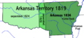
Map of the Arkansas Territory
-
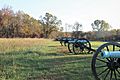
Cannons at Battle of Pea Ridge site
-

A group of African American boys in Little Rock in 1938.
-
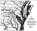
Map of the flood of 1927 in Arkansas
-
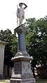
Van Buren Confederate Monument at the Crawford County Courthouse in Van Buren, Arkansas
-
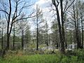
The flooded forests of east Arkansas attract wintering waterfowl.


See also
 In Spanish: Arkansas para niños
