Boundaries between the continents facts for kids
The Earth has seven main landmasses called continents. But where exactly does one continent end and another begin? It's not always as simple as it seems! Geographers often decide these boundaries based on common agreements and features like mountains or rivers.
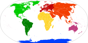
America
North America
South America
Afro-Eurasia
Africa
Eurasia
Europe
Asia
Australia
Antarctica
Most people in English-speaking countries learn about seven continents: Africa, Antarctica, Asia, Australia, Europe, North America, and South America. However, some ways of grouping them might count as few as four, like combining Africa, Europe, and Asia into "Afro-Eurasia," and North and South America into "the Americas."
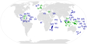
Islands can be tricky! An island is usually linked to a continent if it sits on that continent's underwater shelf (like Singapore or the British Isles). Sometimes, islands are grouped with a continent because of their geology or political connections. For example, many Pacific Islands are grouped with Australia to form Oceania.
There are three main land borders that divide continents:
- Between Africa and Asia: This is at the Isthmus of Suez.
- Between Asia and Europe: This border runs through the Turkish straits, the Caucasus Mountains, and the Ural Mountains and Ural River.
- Between North America and South America: This border is usually found on the Isthmus of Panama, often following the Darién Mountains.
Even though canals like the Suez Canal and Panama Canal make these narrow land connections navigable, the canals themselves aren't usually considered the continental boundaries. The actual boundaries are the very narrow strips of land that naturally connect the continents.
Other boundaries involve how islands and island groups are connected to continents. This includes areas like:
- The Mediterranean Sea (between Africa, Asia, and Europe).
- The Arctic Ocean (between Asia and Europe).
- The North Atlantic Ocean (between Europe and North America).
- The Caribbean Sea (between North and South America).
- The oceans around Antarctica (connecting it to Africa, Australia, and South America).
- The seas between Asia and Australia (like the Ceram Sea and Timor Sea).
- The North Pacific Ocean (between Asia and North America).
Contents
- Africa and Asia: A Narrow Divide
- Africa and Europe: Islands in the Sea
- Antarctica: The Icy Continent
- Asia and Australia: A Complex Border
- Asia and Europe: A Historical Divide
- Asia and North America: Across the Bering Strait
- Europe and North America: The Atlantic Divide
- North America and South America: The Panama Connection
- Oceania and the Americas: Pacific Connections
- See also
Africa and Asia: A Narrow Divide
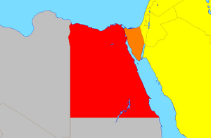
For a long time, people weren't sure where to draw the line between Africa and Asia. Today, the most common boundary is at the Isthmus of Suez. This narrow strip of land connects the Mediterranean Sea and the Gulf of Suez.
This boundary places the Sinai Peninsula in Asia, making Egypt a country that spans two continents. However, most of Egypt's population lives in Africa, so it's usually thought of as an African country. When people talk about the Middle East, Egypt is often grouped with Asian countries, but it's also a member of the African Union.
Several island nations in the Indian Ocean are linked to Africa, such as the Comoros, Madagascar, Mauritius, and Seychelles. The Socotra Archipelago is geologically part of Africa but politically belongs to Yemen, an Asian country.
Africa and Europe: Islands in the Sea
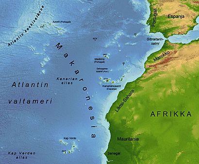
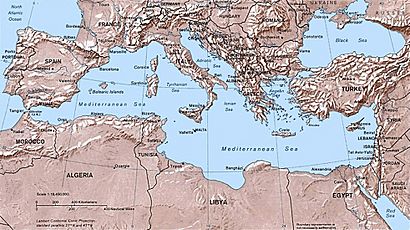
The mainlands of Africa and Europe don't touch, so the boundary is all about which islands belong to which continent.
The Azores, a group of Portuguese islands in the Atlantic, are sometimes grouped with Europe. However, the Canary Islands and Madeira islands, off the coast of Morocco, are much closer to Africa and are usually considered part of it. For example, the Canary Islands are only about 100 km (62 miles) from Africa, but 945 km (587 miles) from Europe.
The Mediterranean island nation of Malta is much closer to Sicily, Italy, than to the African mainland. Geologically, Malta and Sicily are actually on the African Plate, meaning they are technically part of the African continent. But for cultural and political reasons, maps usually show them as part of Europe.
A tiny Spanish island called Alboran Island is also debated. It's located in the Alboran Sea, 50 km (31 miles) north of Morocco and 90 km (56 miles) south of Spain.
European Territories in Africa
There are also some territories that are clearly part of the African continent but are governed by European countries.
- Spain controls the cities of Ceuta and Melilla, which are on the African mainland bordering Morocco. Spain also has small islands called plazas de soberanía near the African coast.
- France governs Mayotte and Réunion, which are islands in the Indian Ocean near Madagascar. France also has some small, uninhabited islands in the Indian Ocean called the Scattered Islands in the Indian Ocean.
These territories can make the lines between continents seem a bit blurry!
Antarctica: The Icy Continent
Antarctica is unique because it has no permanent human population. All land claims south of 60°S latitude are paused by the Antarctic Treaty System, which means no country truly owns any part of it.
Some islands near Antarctica are politically linked to other continents. For example, Australia's Heard Island and McDonald Islands and France's Kerguelen Islands are on the Antarctic continental plate. The United Nations considers Heard Island and McDonald Islands part of Oceania, even though they are very far from Australia and have never been inhabited by people.
The South Georgia and the South Sandwich Islands are closer to Antarctica but are politically linked to the Falkland Islands, which are associated with South America. These islands were uninhabited when Europeans found them. The Falkland Islands have a British population and culture, different from mainland South America.
Asia and Australia: A Complex Border
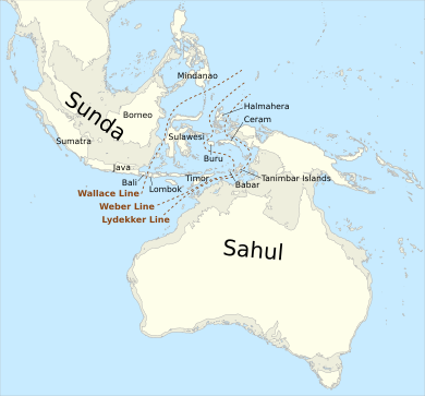
The boundary between Asia and Australia is found in the Malay Archipelago, specifically in a region called Wallacea. This area is known for its unique wildlife, with some animals more like those in Asia and others more like those in Australia.
Two provinces of Indonesia are on the western half of New Guinea, which is geologically part of the Australian continent. The eastern half of New Guinea is the country of Papua New Guinea, which is considered part of Oceania. Indonesia is usually seen as a Southeast Asian country, but because it owns Western New Guinea, it's technically a transcontinental country. Western New Guinea is often considered part of Oceania due to its native Melanesian people and its geological link to Australia.
East Timor, an independent country that used to be part of Indonesia, is classified by the United Nations as part of Southeast Asia.
Sometimes, all of the Malay Archipelago was included in Oceania, but this is rare now because most of it sits on the Asian continental shelf. Many people in the Malay Archipelago are Austronesians, who share family and language ties with the people of Oceania. However, the Austronesians of the Malay Archipelago had more contact with mainland Asia than the isolated people of Oceania.
The Australian territories of Christmas Island and Cocos (Keeling) Islands are near Java, but the United Nations considers them part of Oceania, not Asia. They are on the Australian Plate and have oceanic geology, making them different from both mainland Asia and Australia.
Japan also has some remote islands, like the Bonin Islands and Volcano Islands, which are sometimes considered part of Oceania because of their location and oceanic nature. The most distant of these, Minami-Tori-shima, is closer to Micronesian territories like Guam than to Tokyo.
Australia has a more developed economy than many Pacific Island nations. Because of this, it's sometimes linked to mainland Asia, even though it's geologically different and had no cultural ties to Asia before Europeans arrived. Australia has always been included in definitions of Oceania. Australia, Guam, and the Northern Mariana Islands even compete in the Asian Football Confederation (AFC) for soccer, even though they are geographically part of Oceania. This is mainly because the AFC has more resources than the Oceania Football Confederation.
Taiwan has also been linked to Oceania sometimes, partly because it's an island in the Pacific and its native people are related to those in Oceania. However, Taiwan is very close to China and sits on Asia's continental shelf, so it's usually considered part of Asia. Taiwan used to be in the Oceania Football Confederation for political reasons, but now it's part of the AFC.
Asia and Europe: A Historical Divide
The boundary between Asia and Europe is unique because it often follows mountains and rivers, especially north and east of the Black Sea. These two are seen as separate continents for historical reasons, dating back to ancient Greek geographers.
In a modern sense, Eurasia (Asia and Europe combined) is often seen as one large continent, with Europe sometimes described as a smaller part, or "subcontinent," of Eurasia.
Mainland Boundaries
How the Border Changed Over Time
The idea of dividing the "Old World" into Africa, Asia, and Europe has been around since ancient Greek times (6th century BC).
Early Greek geographers like Anaximander and Hecataeus put the border between Asia and Europe along the Phasis River (modern Rioni River in Georgia). Later, Roman writers like Strabo and Ptolemy moved the border to the Don River.
For centuries, maps followed Ptolemy's idea, with the border going through the Turkish Straits, the Black Sea, the Kerch Strait, the Sea of Azov, and the Don River. But as people explored more, mapmakers started to disagree on where the border went beyond the Don River.
In 1725, Philip Johan von Strahlenberg suggested a new border along the Volga River and the Ural Mountains. By the mid-1800s, there were three main ideas for the border: one along the Don and Volga, another along the Kuma–Manych Depression and Ural River, and a third along the Greater Caucasus watershed.
In Russia and the Soviet Union, the Kuma–Manych Depression border was popular for a while. But later in the 20th century, most geographers in the Soviet Union preferred the border along the Caucasus mountain tops.
Where is the Border Today?
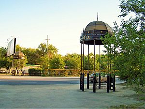
The modern border between Asia and Europe is based on history and culture, so it can still vary. A commonly accepted border follows the Aegean Sea, the Turkish Straits (Dardanelles, Sea of Marmara, Bosporus), the Black Sea, the watershed of the Greater Caucasus mountains, the northwestern part of the Caspian Sea, and then along the Ural River and Ural Mountains to the Kara Sea. This is how most atlases, like National Geographic, show it.
According to this definition, Georgia and Azerbaijan are countries that span two continents, with some northern parts in Europe and the rest in Asia. However, both countries are usually considered European for historical, cultural, and political reasons.
Russia and Turkey are also countries that span both continents. Russia is culturally and politically European, even with its large Asian territory. Kazakhstan is also transcontinental, with parts of its western provinces on both sides of the Ural River. Cities like Istanbul in Turkey, and Magnitogorsk, Orenburg, and Atyrau in Russia and Kazakhstan, are also transcontinental cities.
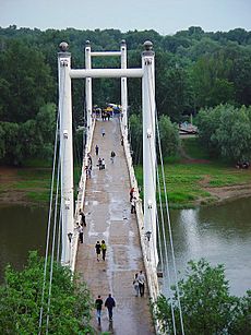
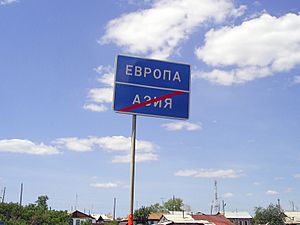
The Ural River is a common boundary, even though it's not a huge mountain range or wide sea. Bridges over the Ural River in cities like Atyrau and Orenburg even have signs marking "Europe" on one side and "Asia" on the other!
The Kuma–Manych Depression is sometimes mentioned as a possible natural boundary, but it's less common now. This definition would place traditionally European areas of Russia, like Stavropol, in Asia, which isn't widely accepted.
The United Nations Statistics Division (UNSD) groups countries for statistical purposes, and their definitions might differ from geographical ones. For example, UNSD puts Georgia and Cyprus in Western Asia, but other UN groups and organizations like the Council of Europe consider them part of Europe. Cyprus is even a member of the European Union.
Islands and the Europe-Asia Border
Cyprus is an island in the Mediterranean Sea. Geologically, it's on the Asian continental shelf, close to Asia Minor. Because of this, it's sometimes grouped with Asia. However, the Republic of Cyprus joined the Council of Europe in 1961 and the EU in 2004, so it's politically considered part of Europe.
Some Greek islands, like the North Aegean islands and the Dodecanese, are very close to the Asian part of Turkey and sit on the Asian continental shelf. So, geographically, they could be seen as part of Asia. But due to their history and culture, they are considered part of Europe.
Russia's Vaygach Island and Novaya Zemlya extend north from the Ural Mountains into the Arctic Ocean. These islands are usually grouped with Europe. The Russian Arctic islands of Franz Josef Land are also associated with Europe.
Asia and North America: Across the Bering Strait
The Bering Strait and Bering Sea separate the landmasses of Asia and North America. This is also where the border between Russia and the United States lies. The Diomede Islands in the Bering Strait are split, with Big Diomede belonging to Russia and Little Diomede to the U.S.
The Aleutian Islands stretch west from Alaska towards Russia. Most of these islands are considered part of North America. However, the westernmost group, the Near Islands, are on Asia's continental shelf and could sometimes be linked to Asia. This would make Alaska a transcontinental state, but this is rare. At their closest points, Alaska and Russia are only about 4 km (2.5 miles) apart!
Europe and North America: The Atlantic Divide
The Atlantic Ocean separates Europe and North America. Some islands are considered part of Europe politically, even if they are far out in the ocean. This includes the British Isles, which are on the European continental shelf.
The Norwegian islands of Jan Mayen and Svalbard in the Arctic Ocean are usually associated with Europe.
South of the Arctic, the boundary for oceanic islands is usually drawn between Greenland and Iceland, and between Bermuda and the Azores. Iceland and the Azores are part of the Mid-Atlantic Ridge and are culturally linked to Europe, even though parts of them are on the North American Plate. It's important to remember that continent definitions are based on geography and culture, not just tectonic plates. Some definitions even place the Europe-America boundary along the Mid-Atlantic Ridge, which would make Iceland a transcontinental country.
Greenland is geographically part of North America. However, politically, it's linked to Europe because it's part of the Kingdom of Denmark. The United Nations considers Greenland part of North America, but Greenland's national soccer team usually plays against European teams.
Some Caribbean islands are directly part of European countries, like Bonaire, Saba, and Sint Eustatius (part of the Netherlands), and Guadeloupe and Martinique (part of France).
North America and South America: The Panama Connection
Mainland Boundary
The border between North America and South America is usually found in the Darién Mountains, which follow the Colombia–Panama border. Most maps show Panama as entirely within North America or Central America.
Islands in the Caribbean
Many Caribbean islands are considered part of North America. However, islands like Aruba, Bonaire, Curaçao, and Trinidad and Tobago are on the continental shelf of South America. On the other hand, Venezuela's Isla Aves and Colombia's San Andrés and Providencia are on the North American shelf.
Oceania and the Americas: Pacific Connections
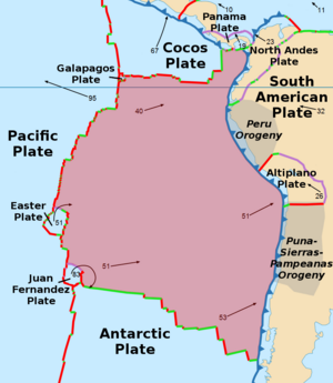
The Galápagos Islands (belonging to Ecuador) and Malpelo Island (belonging to Colombia) are in the southeastern Pacific Ocean. Malpelo is usually linked to South America. The Galápagos Islands, about 1,000 km (620 miles) from Ecuador, are sometimes linked to Oceania because they are far out in the Pacific and have oceanic geology. These islands were never inhabited by native American peoples.
Clipperton Island, a French territory, is on the Pacific Plate about 1,000 km (620 miles) off the coast of Mexico. It's also sometimes associated with Oceania. Its marine life is connected to that of Hawaii and Kiribati's Line Islands.
Easter Island, also known as Rapa Nui, is about 3,500 km (2,175 miles) off the coast of Chile. Culturally, it's part of Polynesia (Oceania) because of its original inhabitants. However, it's politically linked to South America, as Chile took control of it in 1888. Easter Island has tried to connect with other Pacific Island nations.
Similar to Easter Island, Chile's uninhabited Salas y Gómez Island, Desventuradas Islands, and Juan Fernández Islands are also geographically in Oceania but politically linked to South America. Their marine life is very similar to the central Pacific, more so than to nearby South America.
See also
 In Spanish: Límites de los continentes para niños
- List of transcontinental countries
- List of sovereign states and dependent territories by continent
 | Laphonza Butler |
 | Daisy Bates |
 | Elizabeth Piper Ensley |


